Media elements used in this module are protected by a variety of copyright licenses. Please use the "copyright terms" link associated with each item below for more information.
Description:
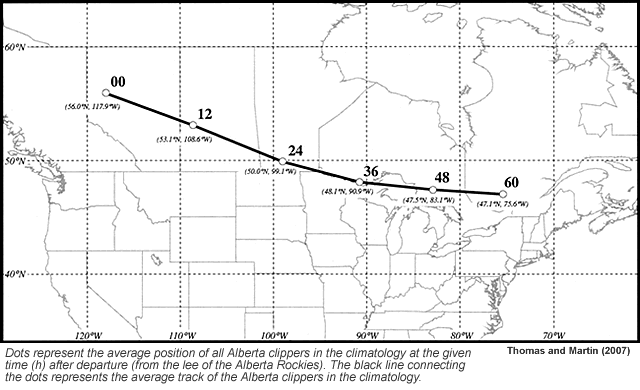
Average of all tracks for Alberta Clippers 1986-2000 in the Thomas and Martin (2007) study.
File Name:
albertaclipper_avg_tracks.gif
Credits:
Thomas and Martin (2007)
Copyright Terms:
COMET Standard Terms
of Use

Description:
Composite fields at various pressure levels for Alberta Clippers in the 1986-2000 study by Thomas and Martin (2007).
File Name:
albertaclipper_composite.gif
Credits:
Thomas and Martin (2007)
Copyright Terms:
COMET Standard Terms
of Use
Description:
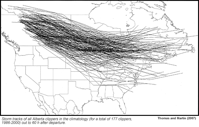
Composite tracks for Alberta Clippers 1986-2000 in the Thomas and Martin (2007) study.
File Name:
albertaclipper_spaghetti.gif
Credits:
Thomas and Martin (2007)
Copyright Terms:
COMET Standard Terms
of Use
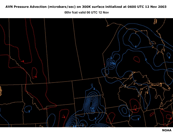
Description:
AVN Pressure Advection (microbars/sec) on 300K surface initialized at 0600 UTC 12 Nov 2003
File Name:
avn_300theta_06z00-18hr_2003_11_11_data1_0001.htm
Credits:
NOAA
Copyright Terms:
COMET Standard Terms
of Use
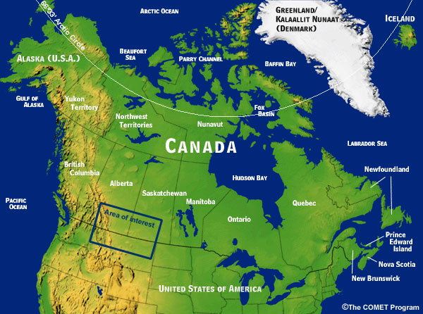
Description:
Map of western Canada and adjoining areas
File Name:
canadabasemap_poli.jpg
Credits:
©The COMET Program
Copyright Terms:
COMET Standard Terms
of Use
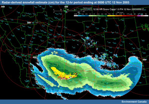
Description:
Radar-derived snowfall (cm) estimate for the 12-hr period ending at 0000 UTC 12 Nov 2003
File Name:
CAPPI_12hr_precip_00z_2003_11_12.gif
Credits:
Environment Canada
Copyright Terms:
COMET Standard Terms
of Use
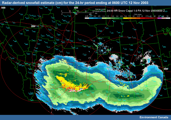
Description:
Radar-derived snowfall (cm) estimate for the 24-hr period ending at 0600 UTC 12 Nov 2003
File Name:
CAPPI_24hr_precip_06z_2003_11_12.gif
Credits:
Environment Canada
Copyright Terms:
COMET Standard Terms
of Use
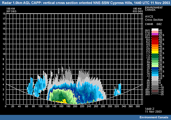
Description:
Vertical cross section of radar reflectivity (dBZ) oriented NNE-SSW and passing through the Cypress Hills region at 1440 UTC 11 Nov 2003
File Name:
CAPPI_xsection_1440_1111.gif
Credits:
Environment Canada
Copyright Terms:
COMET Standard Terms
of Use
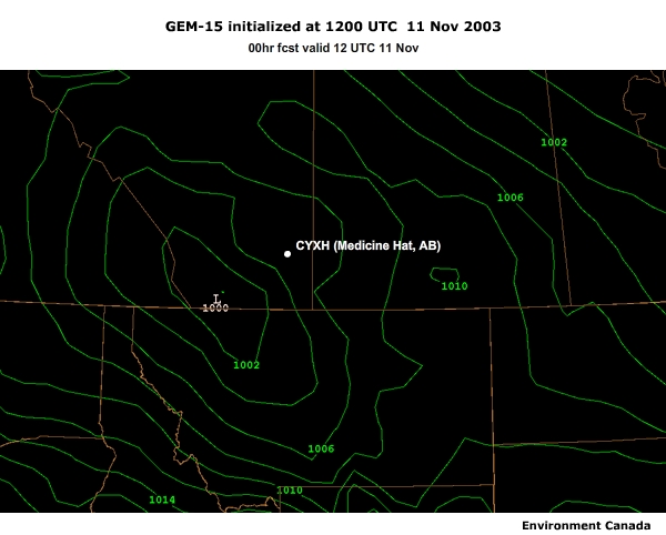
Description:
GEM-15 model forecast of MSLP and 6-hr precipitation totals (mm) for the 12 UTC 11 Nov 2003 run
File Name:
challenge01_mslp_250winds_data1_0001.htm
Credits:
NOAA
Copyright Terms:
COMET Standard Terms
of Use
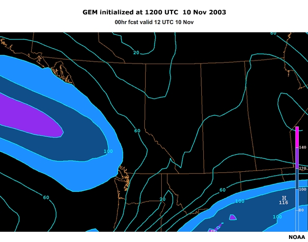
Description:
GEM model forecast of MSLP (mb) and 250mb winds (kts) for the 12 UTC 10 Nov 2003 run
File Name:
challenge01_mslp_250winds_data2_0001.htm
Credits:
NOAA
Copyright Terms:
COMET Standard Terms
of Use
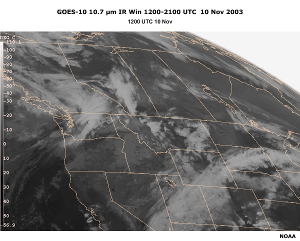
Description:
GOES-10 10.7 µm IR Win 12-21 UTC 10 Nov 2003
File Name:
challenge03_IR4goes10_12-21z10Nov_0001.htm
Credits:
NOAA
Copyright Terms:
COMET Standard Terms
of Use
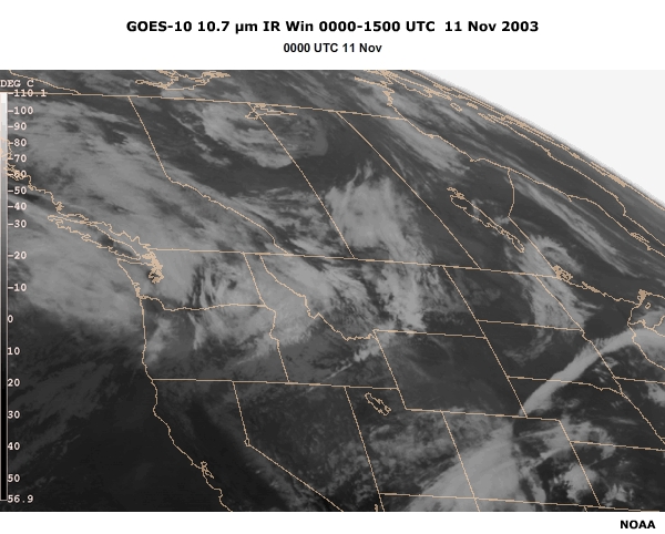
Description:
GOES-10 10.7 µm IR Win 00-15 UTC 11 Nov 2003
File Name:
challenge04_IR4goes10_00-15z11Nov_0001.htm
Credits:
NOAA
Copyright Terms:
COMET Standard Terms
of Use
Description:
GEM model forecast of MSLP (mb) for the 12 UTC 11 Nov 2003 run
File Name:
challenge05_mslp_12z00-48_2003_11_11_0001.htm
Credits:
Environment Canada
Copyright Terms:
COMET Standard Terms
of Use
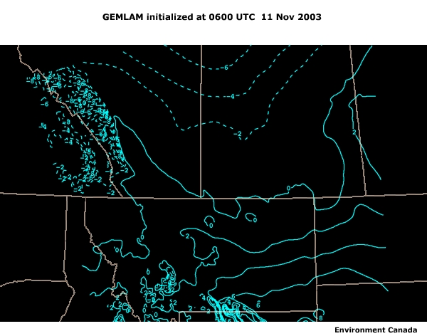
Description:
GEMLAM model forecast of 850 and 700mb temperatures (C) for the 00 and 06 forecasts valid at 06 and 12 UTC 11 Nov 2003
File Name:
challenge07_gemlam_700-850temp_data1_0001.htm
Credits:
Environment Canada
Copyright Terms:
COMET Standard Terms
of Use
Description:
GEM model forecast of MSLP (mb) and 6hr precipitation (mm) for the 12 UTC 11 Nov 2003 run
File Name:
challenge08_mslp_6hrprec_12z00-48_2003_11_11_data2_0001.htm
Credits:
Environment Canada
Copyright Terms:
COMET Standard Terms
of Use
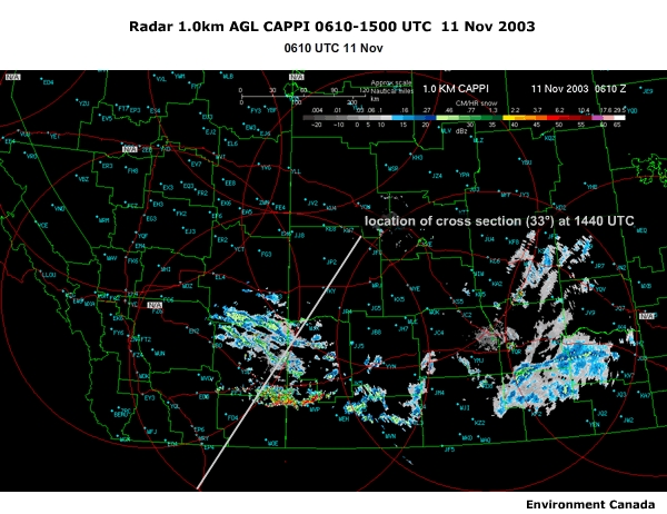
Description:
Prairie radar reflectivity (dBZ) at a 1.0 km CAPPI over the region of interest with cross section at 1440 UTC. Stationary high reflectivity values over the lower center portion of the screen represent the Cypress Hills.
File Name:
challenge09_radar_cappi_06-15z_2003_11_11_data1_0001.htm
Credits:
Environment Canada
Copyright Terms:
COMET Standard Terms
of Use

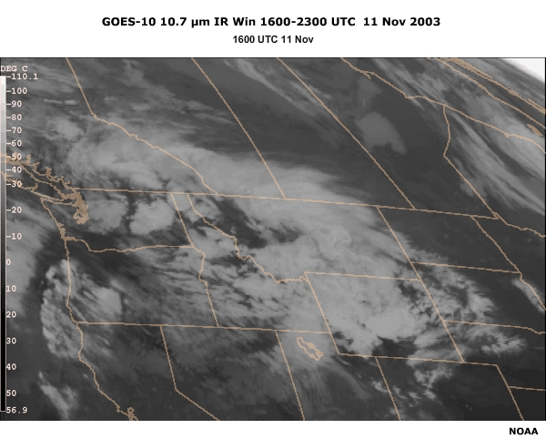
Description:
GOES-10 10.7 µm IR Win 16-23 UTC 11 Nov 2003
File Name:
challenge11_IR4_VISgoes10_16-23z11Nov_data1_0001.htm
Credits:
NOAA
Copyright Terms:
COMET Standard Terms
of Use
Description:
GOES-10 IR4 Win 16-22 UTC 11 Nov 2003
File Name:
challenge11_IR4goes10_16-23z11Nov_data1_0001.htm
Credits:
NOAA
Copyright Terms:
COMET Standard Terms
of Use
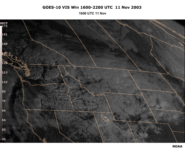
Description:
GOES-10 VIS Win 16-22 UTC 11 Nov 2003
File Name:
challenge11_VISgoes10_16-22z11Nov_data1_0001.htm
Credits:
NOAA
Copyright Terms:
COMET Standard Terms
of Use
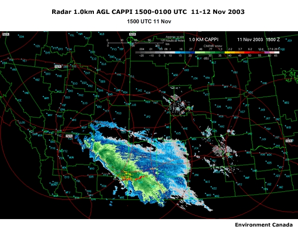
Description:
Prairie radar reflectivity (dBZ) at a 1.0 km CAPPI over the region of interest, 15-01UTC 11-12 Nov 2003. Stationary high reflectivity values over the lower center portion of the screen represent the Cypress Hills.
File Name:
challenge12_radar_cappi_15-01z_2003_11_11-12_data1_0001.htm
Credits:
Environment Canada
Copyright Terms:
COMET Standard Terms
of Use
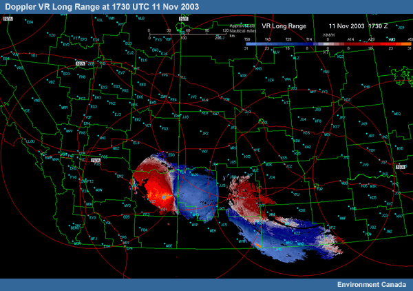
Description:
Doppler velocity (km/hr) CAPPI at 1.0 km, for 1730 UTC 11 Nov 2003 Divide the values in km/hr by approximately 2 to convert the velocities in kt.
File Name:
doppler_comp_vr_1730z_2003_11_11.gif
Credits:
Environment Canada
Copyright Terms:
COMET Standard Terms
of Use
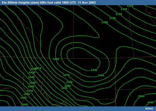
Description:
Eta 850mb Heights (dam) 00hr fcst valid 1800 UTC 11 Nov 2003
File Name:
eta_850height_18z00hr_2003_11_11.gif
Credits:
NOAA
Copyright Terms:
COMET Standard Terms
of Use
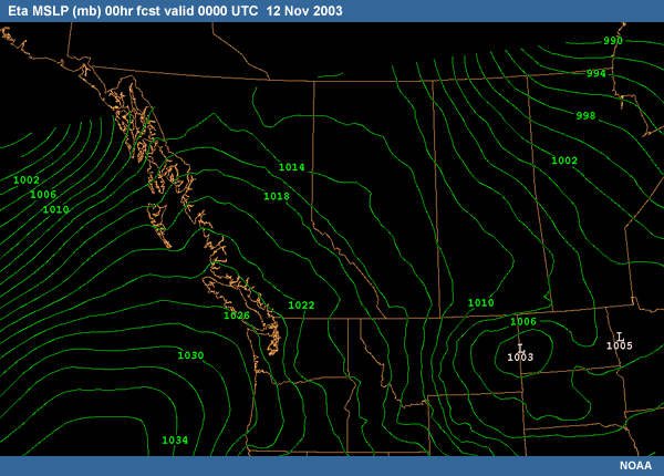
Description:
Eta-analyzed MSLP field (mb), 00 UTC 12 Nov 2003
File Name:
eta_mslp_00z00hr_2003_11_12.gif
Credits:
NOAA
Copyright Terms:
COMET Standard Terms
of Use
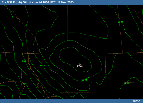
Description:
Eta MSLP (mb) 00hr fcst valid 1800 UTC 11 Nov 2003
File Name:
eta_mslp_18z00hr_2003_11_11.gif
Credits:
NOAA
Copyright Terms:
COMET Standard Terms
of Use
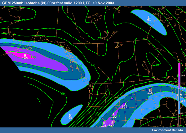
Description:
GEM 250mb Isotachs (kt) 00hr fcst valid 1200 UTC 10 Nov 2003
File Name:
GEM_250mb_isotachs_12z_2003_11_10.gif
Credits:
Environment Canada
Copyright Terms:
COMET Standard Terms
of Use
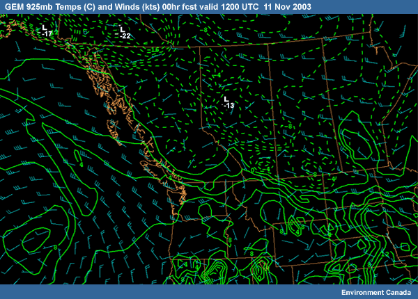
Description:
GEM 925mb Temps (C) and Winds (kts) 00hr fcst valid 1200 UTC 11 Nov 2003
File Name:
GEM_925temp_wind_12z_2003_11_11.gif
Credits:
Environment Canada
Copyright Terms:
COMET Standard Terms
of Use
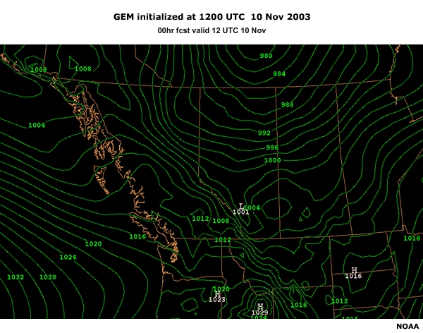
Description:
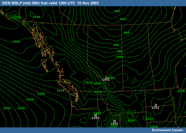
GEM MSLP (mb) 00hr fcst valid 1200 UTC 10 Nov 2003
File Name:
GEM_mslp_00hr12z_2003_11_10.gif
Credits:
Environment Canada
Copyright Terms:
COMET Standard Terms
of Use
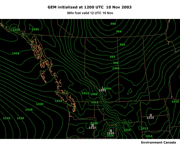
Description:
GEM model forecast of MSLP (mb) for the 48 hours beginning at 1200 UTC 10 Nov.
File Name:
GEM_mslp_12z00-48_2003_11_10_data1_0001.htm
Credits:
Environment Canada
Copyright Terms:
COMET Standard Terms
of Use
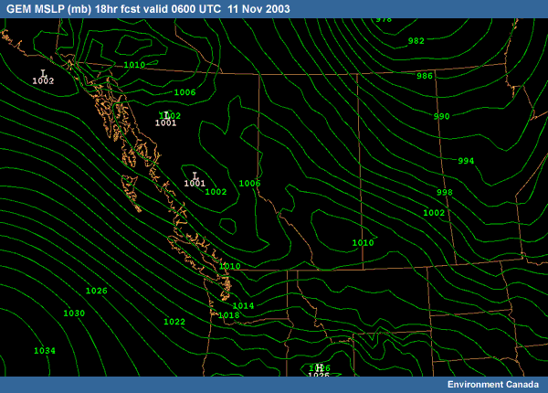
Description:
GEM MSLP (mb) 18hr fcst valid 0600 UTC 11 Nov 2003
File Name:
GEM_mslp_18hr12z_2003_11_10.gif
Credits:
Environment Canada
Copyright Terms:
COMET Standard Terms
of Use
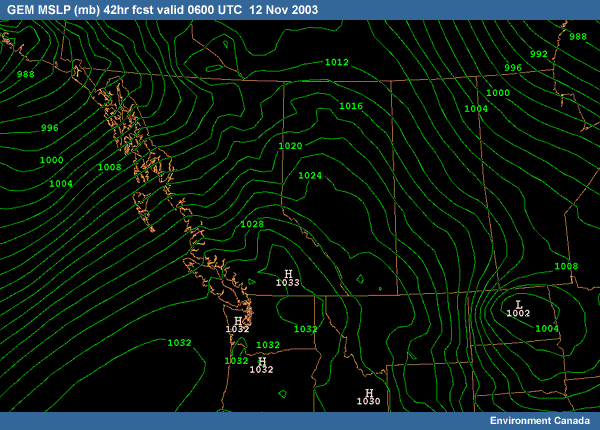
Description:
GEM MSLP (mb) 42hr fcst valid 0600 UTC 12 Nov 2003
File Name:
GEM_mslp_42hr12z_2003_11_10.gif
Credits:
Environment Canada
Copyright Terms:
COMET Standard Terms
of Use

Description:
GEM analyzed surface low pressure center locations at 6-hr intervals from 06 UTC 11 Nov. to 12 UTC 12 Nov.
File Name:
GEM_stormtrack_mslp.gif
Credits:
Environment Canada
Copyright Terms:
COMET Standard Terms
of Use

Description:
GEM-15 6hr Total Precip (mm) 36hr fcst valid 0000 UTC 12 Nov 2003
File Name:
GEM15_6hrprecip_12z36hr_2003_11_10.gif
Credits:
Environment Canada
Copyright Terms:
COMET Standard Terms
of Use
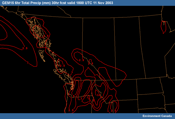
Description:
GEM15 6hr Total Precip (mm) 30hr fcst valid 1800 UTC 11 Nov 2003
File Name:
GEM15_6hrprecip_18z30hr_2003_11_10.gif
Credits:
Environment Canada
Copyright Terms:
COMET Standard Terms
of Use
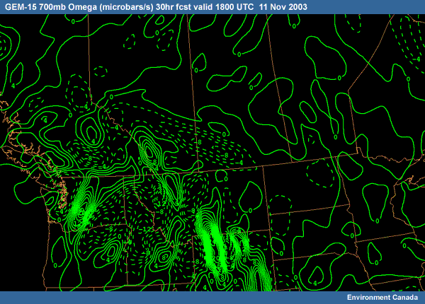
Description:
GEM-15 700mb Omega (microbars/s) 30hr fcst valid 1800 UTC 11 Nov 2003
File Name:
GEM15_700mb_omega_12z30hr_2003_11_10.gif
Credits:
Environment Canada
Copyright Terms:
COMET Standard Terms
of Use
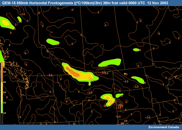
Description:
GEM-15 850mb Horizontal Frontogenesis 36hr fcst valid 0000 UTC 12 Nov 2003
File Name:
GEM15_850mb_frontogen_12z36hr_2003_11_10.gif
Credits:
Environment Canada
Copyright Terms:
COMET Standard Terms
of Use
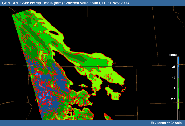
Description:
GEMLAM forecast of 12-hr precipitation accumulation (mm) at 1800 UTC 11 Nov.
File Name:
GEMLAM_12hrprecip_18z12hr_2003_11_11.gif
Credits:
Environment Canada
Copyright Terms:
COMET Standard Terms
of Use
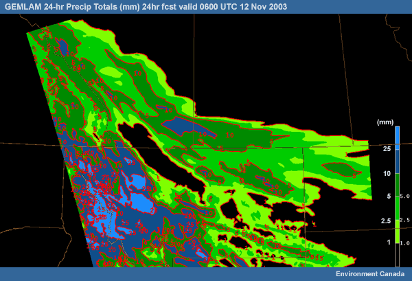
Description:
GEMLAM 24-hr Precip Totals (mm) 24hr fcst valid 0600 UTC 12 Nov 2003
File Name:
GEMLAM_24hrprecip_06z24hr_2003_11_12.gif
Credits:
Environment Canada
Copyright Terms:
COMET Standard Terms
of Use
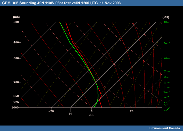
Description:
GEMLAM Sounding 49N 110W 06hr fcst valid 1200 UTC 11 Nov 2003
File Name:
GEMLAM_sounding_12z06hr_2003_11_11.gif
Credits:
Environment Canada
Copyright Terms:
COMET Standard Terms
of Use
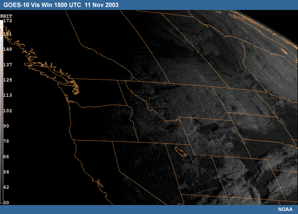
Description:
GOES-10 Vis Win 15 UTC 11 Nov 2003
File Name:
GOES10_vis_15z_2003_11_11.gif
Credits:
NOAA
Copyright Terms:
COMET Standard Terms
of Use
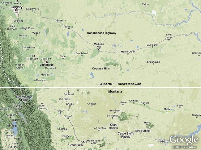
Description:
Terrain map of southern Alberta, southwestern Saskatchewan and northern Montana, courtesy of Google
File Name:
map_alb_sask_mont.jpg
Credits:
©2009 Google, ©2009 Tele Atlas
Copyright Terms:
COMET Standard Terms
of Use
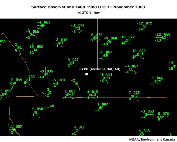
Description:
Surface observations in southern Alberta , Saskatchewan and northern Montana, 15-19 UTC 11 Nov 2003
File Name:
metars_14-19z_2003_11_11_data1_0001.htm
Credits:
NOAA/Environment Canada
Copyright Terms:
COMET Standard Terms
of Use
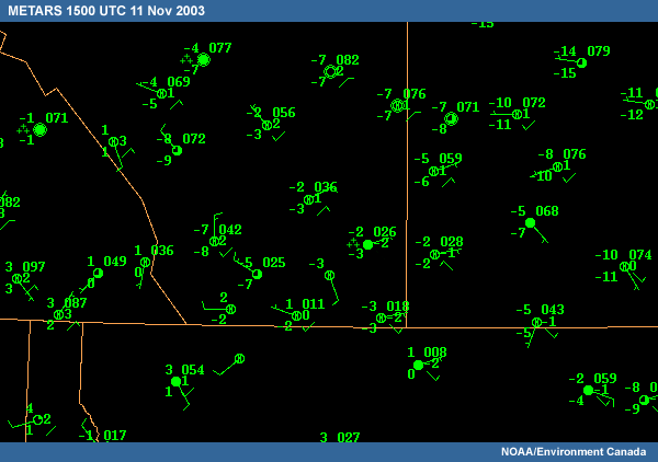
Description:
Surface observations in southern Alberta and Saskatchewan, 15 UTC 11 Nov 2003
File Name:
METARS_15z_2003_11_11.gif
Credits:
NOAA/Environment Canada
Copyright Terms:
COMET Standard Terms
of Use
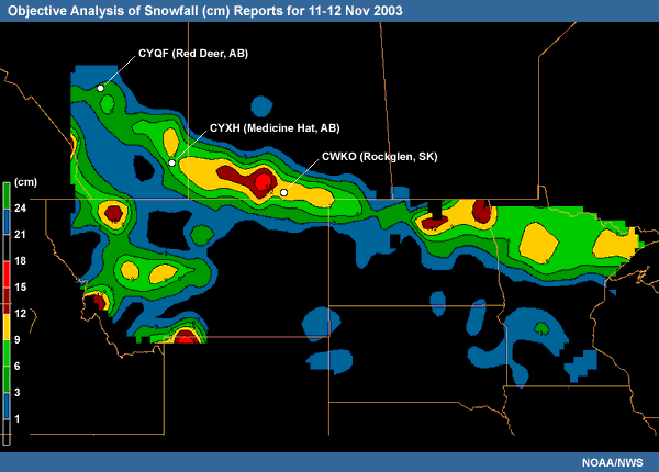
Description:
Objective analysis of snowfall (cm) reports for Nov. 11-12 2003
File Name:
noaa_nws_snowtotalgrid_2003_11_12.gif
Credits:
NOAA/NWS
Copyright Terms:
COMET Standard Terms
of Use
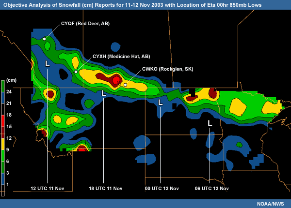
Description:
Objective analysis of snowfall (cm) reports for Nov. 11-12 2003 with Eta 00hr 850 (mb) Low Center Locations at 6-hr intervals from 12-06 UTC 11-12 Nov 2003
File Name:
noaa_snowtotal_850track_2003_11_12.gif
Credits:
NOAA/NWS
Copyright Terms:
COMET Standard Terms
of Use

Description:
Radar 1.0km AGL CAPPI 0610-0100 UTC 11-12 Nov 2003
File Name:
radar_cappi_06-01z_2003_11_11-12_data1_0001.htm
Credits:
Environment Canada
Copyright Terms:
COMET Standard Terms
of Use
Description:
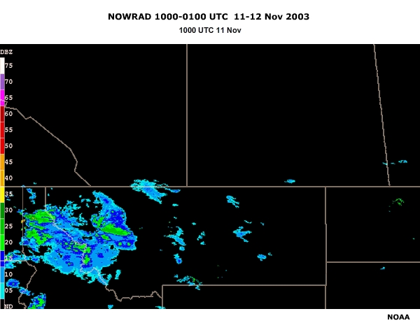
NOWRAD reflectivity (dBZ) 1000-0100 UTC 11-12 November 2003
File Name:
radar_nowrad_10-01z_2003_11_11-12_data1_0001.htm
Credits:
NOAA
Copyright Terms:
COMET Standard Terms
of Use