Media elements used in this module are protected by a variety of copyright licenses. Please use the "copyright terms" link associated with each item below for more information.
Description:
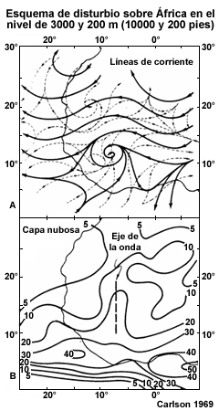
Image description
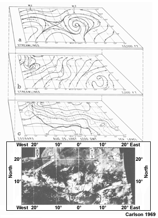
(a) Streamline analysis at 700 hPa; (b) Streamlines at 2000 ft; (c) Surface pressure for 25 August 1967; (b) mosaic of ESSA-5 satellite images at approximately 1500 UTC 25 August 1967
File Name:
african_wave_carlson_1969.gif
Credits:
Carlson 1969
Copyright Terms:
COMET Standard Terms
of Use
Description:
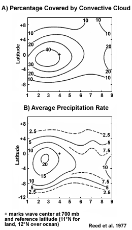
(a) Percentage cover by convective cloud defined as white appearing cloud in SMS-1 infrared images; (b) Average precpitation rate (mm per day)
File Name:
african_wave_clouds_precip.gif
Credits:
Reed et al. 1977
Copyright Terms:
COMET Standard Terms
of Use
Description:
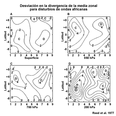
Divergence deviation from zonal means at surface, 850, 700, and 200 hPa. Units are +10 to -6 per second
File Name:
african_wave_divergence.gif
Credits:
Reed et al. 1977
Copyright Terms:
COMET Standard Terms
of Use
Description:
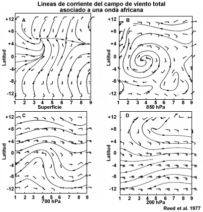
Streamlines and wind barbs at the surface, 850, 700, and 200 hPa. Category separation is approximately 3 degrees longitude. Cross denotes disturbance center at 700 hPa
File Name:
african_wave_horizontal_winds.gif
Credits:
Reed et al. 1977
Copyright Terms:
COMET Standard Terms
of Use
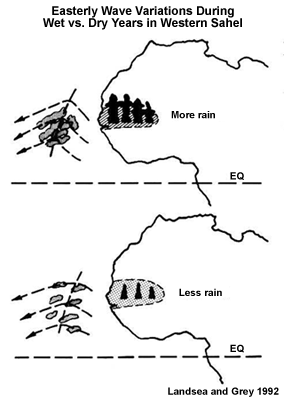
Description:
Idealized portrayal of the easterly wave variations that are suggested to occur during wet (upper panel) versus dry (low panel) western Sahelian years.
File Name:
african_wave_interannual_variability.gif
Credits:
Landsea and Gray 1992
Copyright Terms:
COMET Standard Terms
of Use
Description:
(a) Schematic flow pattern at 10000 ft (solid lines) and 200 ft (dashed lines) for the typical African disturbance; (b) mean percentage cover of cloud with respect to (a). The field represents an average cover for 23 disturbances as measured near 10 degrees W
File Name:
african_wave_schematic.gif
Credits:
Carlson 1969
Copyright Terms:
COMET Standard Terms
of Use
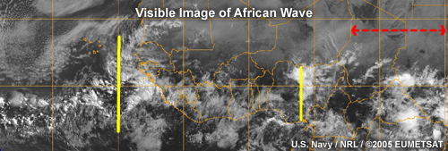
Description:
Visible Image of African Wave
0845 UTC 28 Jun 2005
File Name:
african_wave_vis_20050628_0845.jpg
Credits:
U.S. Navy / NRL/ ©2005 Eumetsat
Copyright Terms:
COMET Standard Terms
of Use
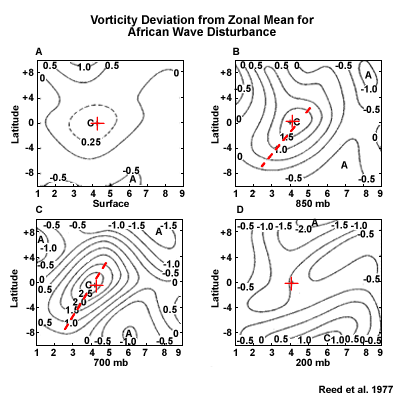
Description:
Vorticity at surface, 850, 700, and 200 hPa. Units are +10 to -5 per second
File Name:
african_wave_vorticity.gif
Credits:
Reed et al. 1977
Copyright Terms:
COMET Standard Terms
of Use
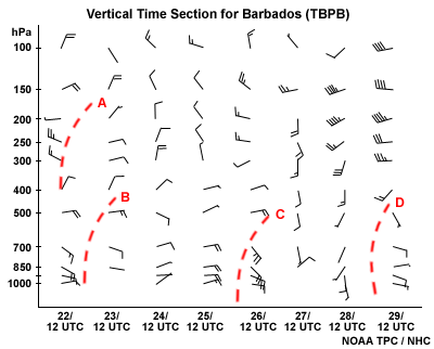
Description:
Vertical Time Section for Barbados (TBPB)
File Name:
bdsxsctn.gif
Credits:
NOAA TPC/NHC
Copyright Terms:
COMET Standard Terms
of Use
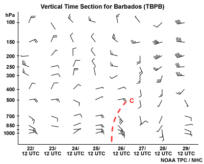
Description:
Vertical Time Section for Barbados (TBPB)
File Name:
bdsxsctn_a.gif
Credits:
NOAA TPC/NHC
Copyright Terms:
COMET Standard Terms
of Use
Description:
Schematic of Frank's Inverted "V" wave model showing cloud bands resembling a nested series of upside-down "V's"
File Name:
frank_sat_invert_v_1_anim.gif
Credits:
NOAA / NESDIS
Copyright Terms:
COMET Standard Terms
of Use

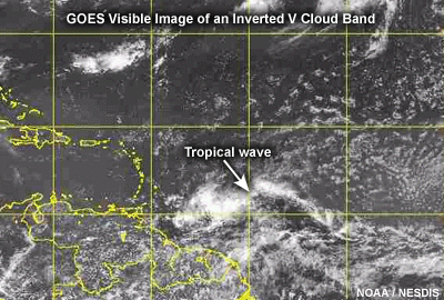
Description:
Satellite image of an "inverted V" wave
File Name:
frank_sat_invert_v_1a.gif
Credits:
NOAA / NESDIS
Copyright Terms:
COMET Standard Terms
of Use

Description:
Satellite image of tropical wave with "inverted V" cloud bands
File Name:
frank_sat_invert_v_1b.gif
Credits:
NOAA / NESDIS
Copyright Terms:
COMET Standard Terms
of Use
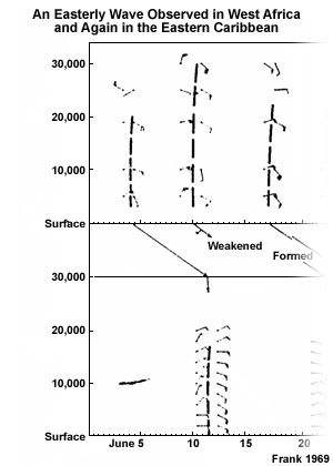
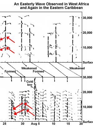
Description:
Time section of soundings taken in West Africa and the eastern Caribbean showing a series of easterly wave passages in each location
File Name:
frank_time_series_1.gif
Credits:
Frank 1969
Copyright Terms:
COMET Standard Terms
of Use
Description:
Time section of soundings taken in West Africa and the eastern Caribbean showing a series of easterly wave passages in each location
File Name:
frank_time_series_2b.gif
Credits:
Frank 1969
Copyright Terms:
COMET Standard Terms
of Use
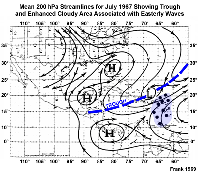
Description:
Mean 200 hPa streamlines for July 1967 showing trough and enhanced cloudy area associated with easterly waves
File Name:
franks_model_caribbeantrough.gif
Credits:
Frank 1969
Copyright Terms:
COMET Standard Terms
of Use
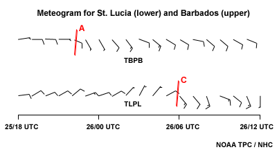
Description:
Answer for Quiz Question 8
Red lines mark passage of a tropical wave across St. Lucia (lower) and Barbados (upper)
File Name:
mgram_a.gif
Credits:
NOAA TPC/NHC
Copyright Terms:
COMET Standard Terms
of Use
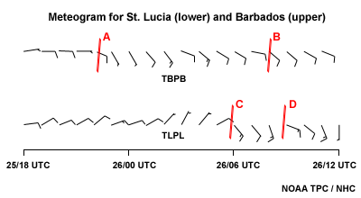
Description:
Image for Quiz Question 8
Meteograms for St. Lucia (lower) and Barbados (upper)
File Name:
mgram_r.gif
Credits:
NOAA TPC/NHC
Copyright Terms:
COMET Standard Terms
of Use
Description:
Model output showing centers of cyclonic vorticity used to track waves over the ocean
File Name:
model_tracking_1.gif
Credits:
NOAA
Copyright Terms:
COMET Standard Terms
of Use
Description:
Scatterometer-derived winds from QuikSCAT microwave sensor. Black barbs indicate possible rain contamination.
File Name:
quik_scat_tracking.gif
Credits:
NASA / NOAA/NESDIS/ORA
Copyright Terms:
COMET Standard Terms
of Use

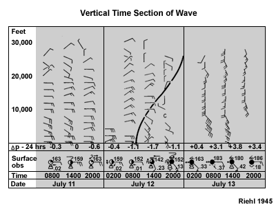
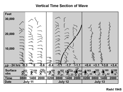
Description:
Riehl’s Vertical Time Section Across a Wave
File Name:
riehl_vert_time_xsect.gif
Credits:
Riehl 1945
Copyright Terms:
COMET Standard Terms
of Use
Description:
Riehl’s Vertical Time Section Across a Wave
File Name:
riehl_vert_time_xsect.gif
Credits:
Riehl 1945
Copyright Terms:
COMET Standard Terms
of Use
Description:
Vertical Cross-section through a Tropical Wave
File Name:
riehl_vert_time_xsect_1.gif
Credits:
adapted Riehl 1948
Copyright Terms:
COMET Standard Terms
of Use
Description:
Riehl's Model: Vertical Cross-section
File Name:
riehl_vert_time_xsect_2.gif
Credits:
Riehl 1945
Copyright Terms:
COMET Standard Terms
of Use
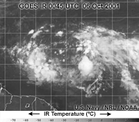
Description:
Satellite infrared image of two tropical waves over the Atlantic
File Name:
sat_tracking_1.gif
Credits:
U.S. Navy / NRL / NOAA
Copyright Terms:
COMET Standard Terms
of Use
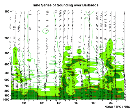
Description:
Time series of soundings taken at Grantley Adams Airport, Barbados showing passage of tropical waves. Light and dark green shading shows relative humidity greater than or equal to 50% and 75% respectively.
File Name:
time_series_winds_barbados.gif
Credits:
NOAA/TPC/NHC
Copyright Terms:
COMET Standard Terms
of Use
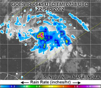
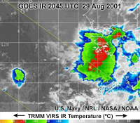
Description:
Satellite image from NRL Tropical Cyclone Website: TRMM TMI and GOES_IR image of tropical wave
File Name:
trop_wave_1_tmi_goes.jpg
Credits:
U.S. Navy / NRL / NASA / NOAA
Copyright Terms:
COMET Standard Terms
of Use
Description:
Satellite image from NRL Tropical Cyclone Website: Grey-scale GOES_IR image of tropical wave
File Name:
trop_wave_2_goes.jpg
Credits:
U.S. Navy / NRL / NOAA
Copyright Terms:
COMET Standard Terms
of Use
Description:
Satellite image from NRL Tropical Cyclone Website: Enhanced GOES_IR image of tropical wave
File Name:
trop_wave_3_goes_enhanced_ir.jpg
Credits:
U.S. Navy / NRL / NOAA
Copyright Terms:
COMET Standard Terms
of Use
Description:
Satellite image animation of tropical waves and tropical cyclones over tropical north Atlantic
File Name:
trop_wave_animation_01.htm
Credits:
US Navy/ NRL/ NOAA/ Copyright symbol 2005 Eumetsat
Copyright Terms:
COMET Standard Terms
of Use
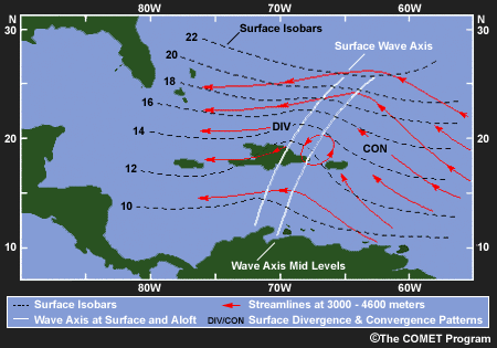
Description:
COMET Graphic: Schematic of Tropical Wave
File Name:
tropical_wave_comet_schematic.gif
Credits:
©The COMET Program
Copyright Terms:
COMET Standard Terms
of Use
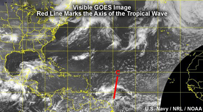
Description:
Solution to Quiz Question 10
Satellite image of tropical wave. Red line marks the axis of the tropical wave
File Name:
vis_0116_a.jpg
Credits:
U.S. Navy / NRL / NOAA
Copyright Terms:
COMET Standard Terms
of Use
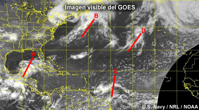
Description:
Image for Question 10
Satellite image of the Caribbean and western Atlantic
File Name:
vis_0116_r.jpg
Credits:
U.S. Navy / NRL / NOAA
Copyright Terms:
COMET Standard Terms
of Use
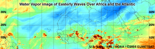
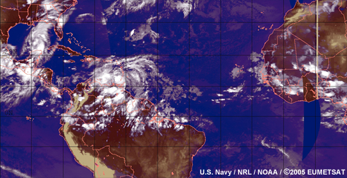
Description:
Water Vapor image of easterly waves over Africa and the Atlantic
File Name:
waves_20050708_1515.jpg
Credits:
U.S. Navy / NRL/ NOAA/ ©2005 Eumetsat
Copyright Terms:
COMET Standard Terms
of Use