Media elements used in this module are protected by a variety of copyright licenses. Please use the "copyright terms" link associated with each item below for more information.
Description:
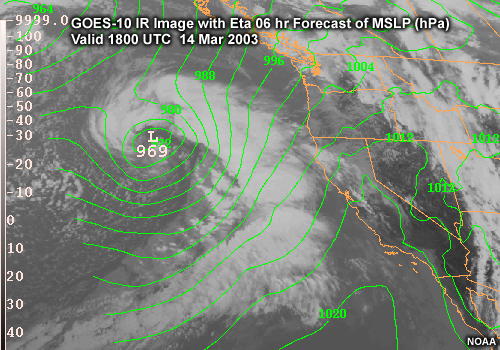
Loop of GOES-10 IR Image with Eta forecast MSLP 1800 UTC 14 Mar 2003 to 1500 UTC 15 Mar 2003, along the U.S. West Coast
File Name:
15mar_ir_mslp_01.htm
Credits:
NOAA
Copyright Terms:
COMET Standard Terms
of Use
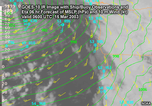
Description:
GOES-10 IR Image with Ship / Buoy Observations and Eta Forecast of MSLP (hPa) and 10 m Wind (kt)
0600 UTC 15 Mar 2003 to 1800 UTC 15 Mar 2003
along the U.S. West Coast
File Name:
15mar_irobs_mslpwind_post_01.htm
Credits:
NOAA
Copyright Terms:
COMET Standard Terms
of Use
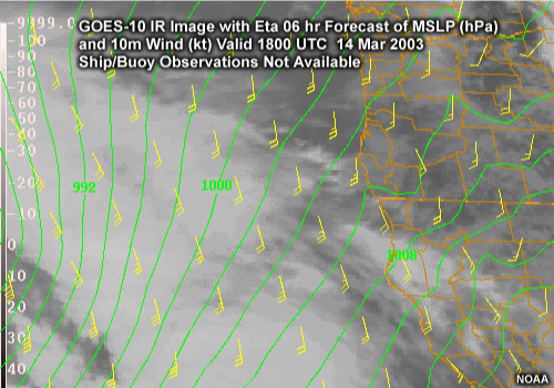
Description:
GOES-10 IR Image with Ship / Buoy Observations and Eta 24 hr Forecast of MSLP (hPa) and 10 m Wind (kt) Valid 1200 UTC 15 Mar 2003 along the U.S. West Coast
File Name:
15mar_irobs_mslpwind_pre_01.htm
Credits:
NOAA
Copyright Terms:
COMET Standard Terms
of Use
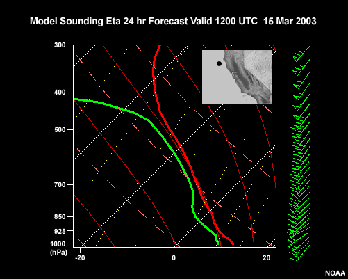
Description:
Postfrontal model Sounding for a location near Cape Mendocino, CA. Eta 24 hr Forecast Valid 1200 UTC 15 Mar 2003
File Name:
15mar_sounding.gif
Credits:
NOAA
Copyright Terms:
COMET Standard Terms
of Use
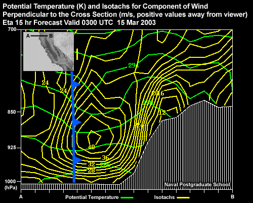
Description:
Potential Temperature (K) and Isotachs for Component of Wind Perpendicular to the Cross Section (kt, positive values away from viewer). Eta 15 hr Forecast Valid 0300 UTC 15 Oct 2003 Cross Section located across the coast of Northern California.
File Name:
15mar_xs_normwindtheta._1.gif
Credits:
NOAA
Copyright Terms:
COMET Standard Terms
of Use
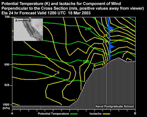
Description:
Potential Temperature (K) and Isotachs for Component of Wind Perpendicular to the Cross Section (kt, positive values away from viewer). Eta 24 hr Forecast Valid 1200 UTC 15 Oct 2003 Cross Section located across the coast of Northern California.
File Name:
15mar_xs_normwindtheta._2.gif
Credits:
NOAA
Copyright Terms:
COMET Standard Terms
of Use
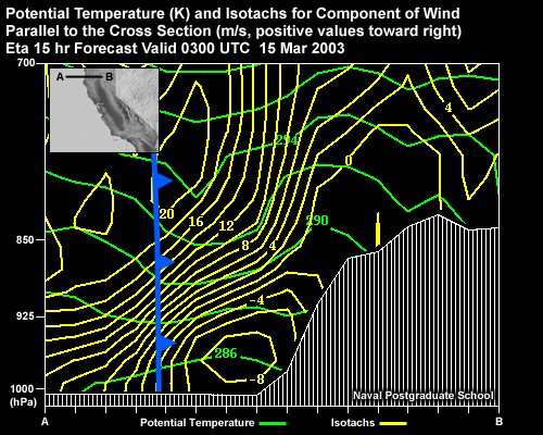
Description:
Potential Temperature (K) and Isotachs for Component of Wind Parallel to the Cross Section (kt, positive values toward right). Eta 15 hr Forecast Valid 0300 UTC 15 Oct 2003 Cross Section located across the coast of Northern California.
File Name:
15mar_xs_tangwindtheta._1.gif
Credits:
NOAA
Copyright Terms:
COMET Standard Terms
of Use
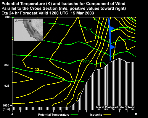
Description:
Potential Temperature (K) and Isotachs for Component of Wind Parallel to the Cross Section (kt, positive values toward right). Eta 24 hr Forecast Valid 1200 UTC 15 Oct 2003 Cross Section located across the coast of Northern California.
File Name:
15mar_xs_tangwindtheta._2.gif
Credits:
NOAA
Copyright Terms:
COMET Standard Terms
of Use
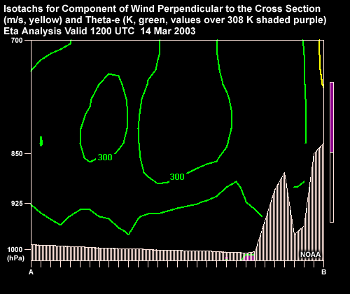
Description:
Loop of Vertical Cross Sections of Isotachs for Component of Wind Perpendicular to the Cross Section (m/s, yellow) and Theta-e (K, green, values over 308 K shaded purple).
File Name:
15mar_xs_thetae_isotachs_01.htm
Credits:
NOAA
Copyright Terms:
COMET Standard Terms
of Use
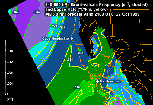
Description:
840-950 hPa Brunt Vaisala Frequency (s, shaded) and Lapse Rate (C/km, yellow). MM5 9 hr Forecast Valid 2100 UTC 27 Oct 1999.
File Name:
26oct_bvlapse.jpg
Credits:
Naval Postgraduate School
Copyright Terms:
COMET Standard Terms
of Use
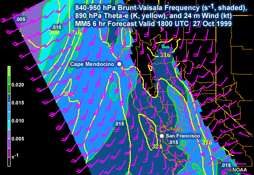
Description:
840-950 hPa Brunt Vaisala Frequency (s, shaded), 890 hPa Theta-e (K, yellow), and 24m Wind (kt). MM5 6 hr Forecast Valid 1800 UTC 27 Oct 1999.
File Name:
26oct_bvthetaewind_1.jpg
Credits:
NOAA
Copyright Terms:
COMET Standard Terms
of Use
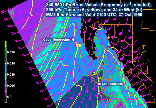
Description:
840-950 hPa Brunt Vaisala Frequency (s, shaded), 890 hPa Theta-e (K, yellow), and 24m Wind (kt). MM5 9 hr Forecast Valid 2100 UTC 27 Oct 1999.
File Name:
26oct_bvthetaewind_2.jpg
Credits:
Naval Postgraduate School
Copyright Terms:
COMET Standard Terms
of Use
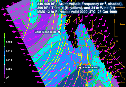
Description:
840-950 hPa Brunt Vaisala Frequency (s, shaded), 890 hPa Theta-e (K, yellow), and 24m Wind (kt). MM5 9 hr Forecast Valid 2100 UTC 27 Oct 1999.
File Name:
26oct_bvthetaewind_3.jpg
Credits:
Naval Postgraduate School
Copyright Terms:
COMET Standard Terms
of Use
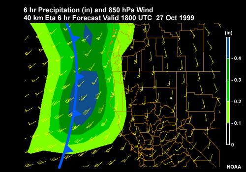
Description:
6 hr Precipitation (in) and Wind (kt) Eta 6 hr Forecast Valid 1800 UTC 27 Oct 1999 along the U.S. West Coast
File Name:
26oct_eta_precipwind_2.jpg
Credits:
NOAA
Copyright Terms:
COMET Standard Terms
of Use
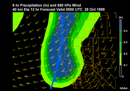
Description:
6 hr Precipitation (in) and Wind (kt) Eta 12 hr Forecast Valid 0000 UTC 28 Oct 1999 along the U.S. West Coast
File Name:
26oct_eta_precipwind_3.jpg
Credits:
NOAA
Copyright Terms:
COMET Standard Terms
of Use
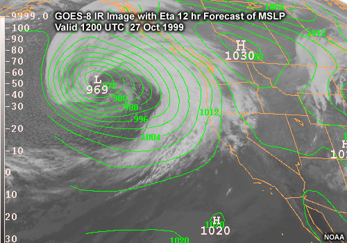
Description:
GOES-8 IR Image with Eta 12 hr Forecast of MSLP valid 1200 UTC 27 Oct 1999 along the U.S. West Coast
File Name:
26oct_ir_mslp_1.jpg
Credits:
NOAA
Copyright Terms:
COMET Standard Terms
of Use
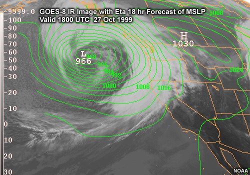
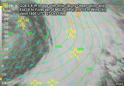
Description:
GOES-8 IR Image with Eta 18 hr Forecast of MSLP valid 1800 UTC 27 Oct 1999 along the U.S. West Coast
File Name:
26oct_ir_mslp_2.jpg
Credits:
NOAA
Copyright Terms:
COMET Standard Terms
of Use
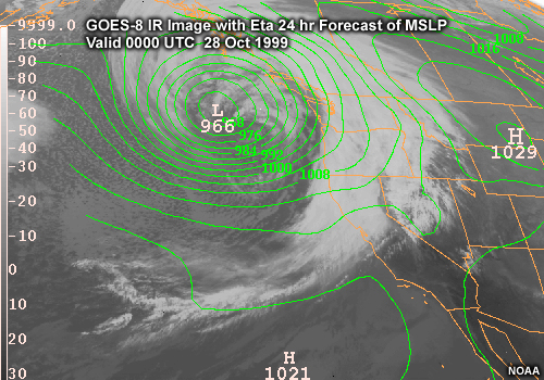
Description:
GOES-8 IR Image with Eta 24 hr Forecast of MSLP valid 0000 UTC 28 Oct 1999 along the U.S. West Coast
File Name:
26oct_ir_mslp_3.jpg
Credits:
NOAA
Copyright Terms:
COMET Standard Terms
of Use
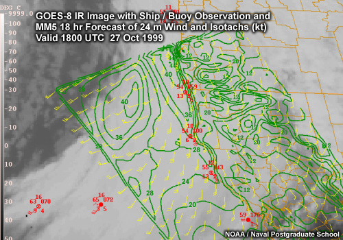
Description:
GOES-8 IR Image with Ship/Buoy Observations and MM5 18 hr Forecast of Wind and Isotachs (kt) Valid 1800 UTC 27 Oct 1999
File Name:
26oct_ir_obs_mm5wind.jpg
Credits:
NOAA / Naval Postgraduate School
Copyright Terms:
COMET Standard Terms
of Use
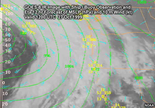
Description:
GOES-8 IR Image with Ship / Buoy Observations and Eta 12 hr Forecast of MSLP (hPa) and Wind (kt) Valid 1200 UTC 27 Oct 1999 along the U.S. West Coast
File Name:
26oct_ir_obs_mslpwind_zoom_1.jpg
Credits:
NOAA
Copyright Terms:
COMET Standard Terms
of Use
Description:
GOES-8 IR Image with Ship / Buoy Observations and Eta 18 hr Forecast of MSLP (hPa) and Wind (kt) Valid 1800 UTC 27 Oct 1999 along the U.S. West Coast
File Name:
26oct_ir_obs_mslpwind_zoom_2.jpg
Credits:
NOAA
Copyright Terms:
COMET Standard Terms
of Use
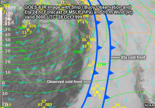
Description:
GOES-8 IR Image with Ship / Buoy Observations and Eta 24 hr Forecast of MSLP (hPa) and Wind (kt) Valid 0000 UTC 28 Oct 1999 along the U.S. West Coast
File Name:
26oct_ir_obs_mslpwind_zoom_3.jpg
Credits:
NOAA
Copyright Terms:
COMET Standard Terms
of Use
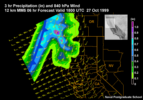
Description:
3 hr Precipitation (in) and Wind (kt) MM5 6 hr Forecast Valid 1800 UTC 27 Oct 1999 along the U.S. West Coast
File Name:
26oct_mm5_precipwind_1.jpg
Credits:
Naval Postgraduate School
Copyright Terms:
COMET Standard Terms
of Use
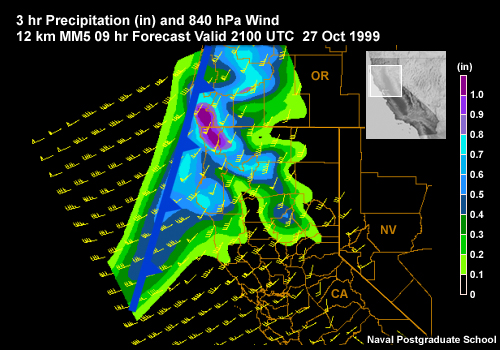
Description:
3 hr Precipitation (in) and Wind (kt) MM5 9 hr Forecast Valid 2100 UTC 27 Oct 1999 along the U.S. West Coast
File Name:
26oct_mm5_precipwind_2.jpg
Credits:
Naval Postgraduate School
Copyright Terms:
COMET Standard Terms
of Use
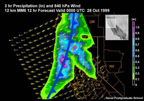
Description:
3 hr Precipitation (in) and Wind (kt) MM5 12 hr Forecast Valid 0000 UTC 28 Oct 1999 along the U.S. West Coast
File Name:
26oct_mm5_precipwind_3.jpg
Credits:
Naval Postgraduate School
Copyright Terms:
COMET Standard Terms
of Use
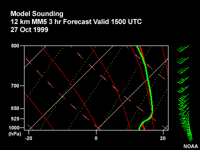
Description:
Loop of 12-km MM5 model soundings, 1500 UTC 27 Oct 1999 to 0300 UTC 28 Oct 1999 for a location off Cape Mendocino, CA.
File Name:
26oct_mm5sounding_01.htm
Credits:
Naval Postgraduate School
Copyright Terms:
COMET Standard Terms
of Use
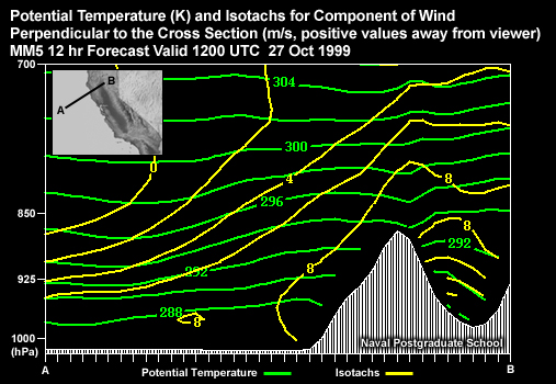
Description:
Potential Temperature (K) and Isotachs for Component of Wind Perpendicular to the Cross Section (kt, positive values away from viewer). MM5 12 hr Forecast Valid 1200 UTC 27 Oct 1999 Cross Section located across the coast of Northern California.
File Name:
26oct_xs_normwindtheta_1.jpg
Credits:
Naval Postgraduate School
Copyright Terms:
COMET Standard Terms
of Use
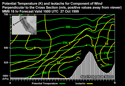
Description:
Potential Temperature (K) and Isotachs for Component of Wind Perpendicular to the Cross Section (kt, positive values away from viewer). MM5 15 hr Forecast Valid 1500 UTC 27 Oct 1999 Cross Section located across the coast of Northern California.
File Name:
26oct_xs_normwindtheta_2.jpg
Credits:
Naval Postgraduate School
Copyright Terms:
COMET Standard Terms
of Use
Description:
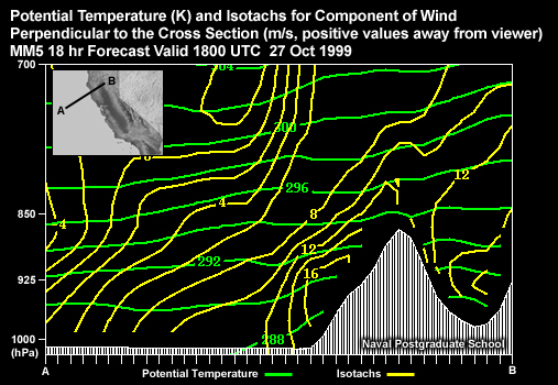
Potential Temperature (K) and Isotachs for Component of Wind Perpendicular to the Cross Section (kt, positive values away from viewer). MM5 18 hr Forecast Valid 1800 UTC 27 Oct 1999 Cross Section located across the coast of Northern California.
File Name:
26oct_xs_normwindtheta_3.jpg
Credits:
Naval Postgraduate School
Copyright Terms:
COMET Standard Terms
of Use
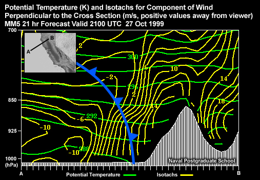
Description:
Potential Temperature (K) and Isotachs for Component of Wind Perpendicular to the Cross Section (kt, positive values away from viewer). MM5 21 hr Forecast Valid 2100 UTC 27 Oct 1999 Cross Section located across the coast of Northern California.
File Name:
26oct_xs_normwindtheta_4.jpg
Credits:
Naval Postgraduate School
Copyright Terms:
COMET Standard Terms
of Use
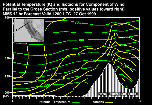
Description:
Potential Temperature (K) and Isotachs for Component of Wind Parallel to the Cross Section (kt, positive values toward right). MM5 12 hr Forecast Valid 1200 UTC 27 Oct 1999 Cross Section located across the coast of Northern California.
File Name:
26oct_xs_tangwindtheta_1.jpg
Credits:
Naval Postgraduate School
Copyright Terms:
COMET Standard Terms
of Use
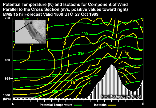
Description:
Potential Temperature (K) and Isotachs for Component of Wind Parallel to the Cross Section (kt, positive values toward right). MM5 15 hr Forecast Valid 1500 UTC 27 Oct 1999 Cross Section located across the coast of Northern California.
File Name:
26oct_xs_tangwindtheta_2.jpg
Credits:
Naval Postgraduate School
Copyright Terms:
COMET Standard Terms
of Use
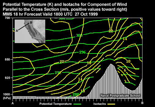
Description:
Potential Temperature (K) and Isotachs for Component of Wind Parallel to the Cross Section (kt, positive values toward right). MM5 18 hr Forecast Valid 1800 UTC 27 Oct 1999 Cross Section located across the coast of Northern California.
File Name:
26oct_xs_tangwindtheta_3.jpg
Credits:
Naval Postgraduate School
Copyright Terms:
COMET Standard Terms
of Use
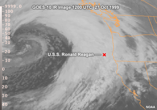
Description:
GOES 10 IR image 1200UTC 27 Oct 1999 over the U.S. West Coast showing an approaching cyclone and scenario location of the USS Ronald Reagan
File Name:
27oct_ir.jpg
Credits:
NOAA / The COMET Program
Copyright Terms:
COMET Standard Terms
of Use
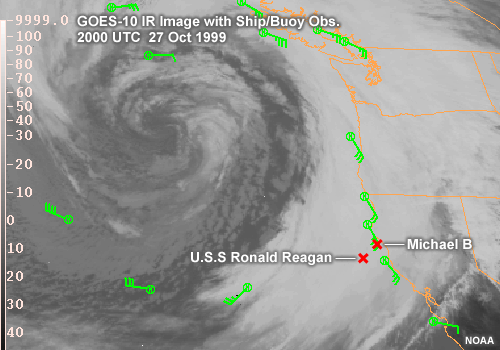
Description:
GOES-10 IR Image with Ship/Buoy Obs.
2000 UTC 27 Oct 1999,
2200 UTC 27 Oct 1999, and
2300 UTC 27 Oct 1999
File Name:
27oct_irobs_01.htm
Credits:
NOAA
Copyright Terms:
COMET Standard Terms
of Use
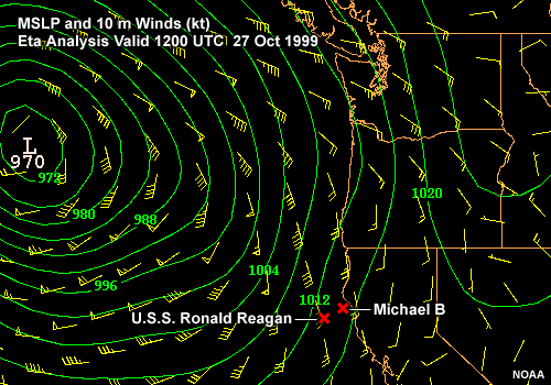
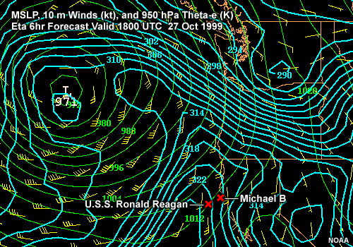
Description:
MSLP and 10m Winds (kt).
Eta Forecast 1200 UTC 27 Oct 1999 to 0600 UTC 28 Oct 1999
File Name:
27oct_mslpwind_01.htm
Credits:
NOAA
Copyright Terms:
COMET Standard Terms
of Use
Description:
MSLP, 10m Winds (kt), and 950 hPa Theta-e (K).
Eta Forecast 1800 UTC 27 Oct 1999 to 0600 UTC 28 Oct 1999
File Name:
27oct_mslpwindthetae_01.htm
Credits:
NOAA
Copyright Terms:
COMET Standard Terms
of Use
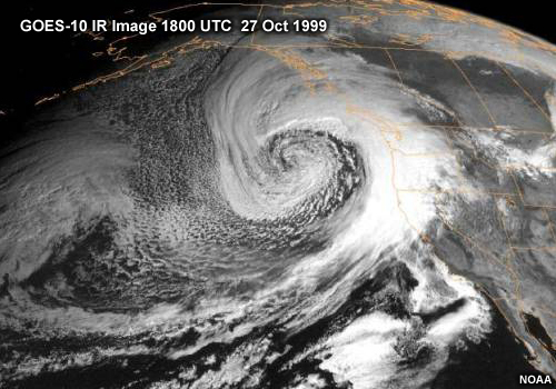
Description:
GOES-10 VIS Image of the U.S. West Coast 1800 UTC 27 Oct 1999
File Name:
27oct_vis.jpg
Credits:
NOAA
Copyright Terms:
COMET Standard Terms
of Use
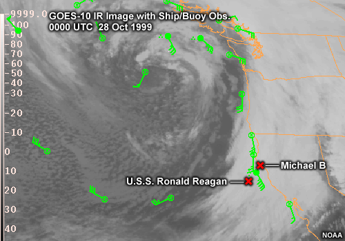
Description:
GOES-10 IR Image with Ship/Buoy Obs.
0000 UTC 28 Oct 1999
File Name:
28oct_irobs.gif
Credits:
NOAA
Copyright Terms:
COMET Standard Terms
of Use
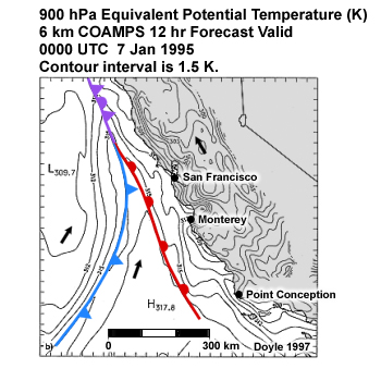
Description:
900-mb equivalent potential temperature (K) along the California coast. 6 km COAMPS 12 hr Forecast Valid 0000 UTC 7 Jan 1995. Contour interval is 1.5 K.
File Name:
7jan95_900thetae.jpg
Credits:
Doyle 1997
Copyright Terms:
COMET Standard Terms
of Use
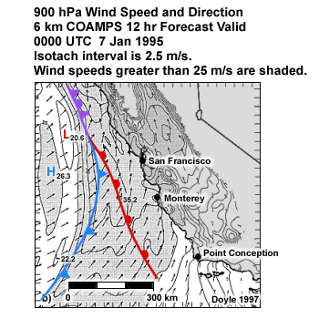
Description:
Plot of 900 hPa wind and windspeed.
File Name:
7jan95_900wind.jpg
Credits:
Doyle 1997
Copyright Terms:
COMET Standard Terms
of Use
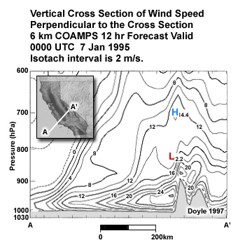
Description:
Vertical cross section of wind speed perpendicular to the cross-section across the CA coast 6 km COAMPS 12 hr Forecast Valid 0000 UTC 7 Jan 1995. Isotach interval is 2 m/s.
File Name:
7jan95_900windxs.jpg
Credits:
Doyle 1997
Copyright Terms:
COMET Standard Terms
of Use
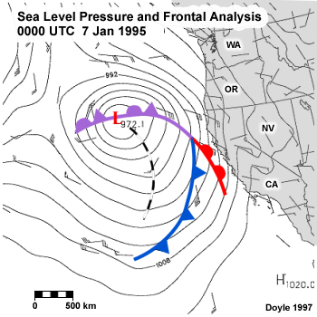
Description:
Sea level pressure and frontal analyses for 0000 UTC 7 January 1995 along the U.S. West Coast. The isobars are plotted every 4 mb. The tick mark interval around the border is 45 km.
File Name:
7jan95_slp.jpg
Credits:
Doyle 1997
Copyright Terms:
COMET Standard Terms
of Use
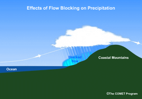
Description:
2-D conceptual animation showing the effect of flow blocking on precip distribution across a ridge
File Name:
blocking_precip.mp4
Credits:
©The COMET Program
Copyright Terms:
COMET Standard Terms
of Use
Description:
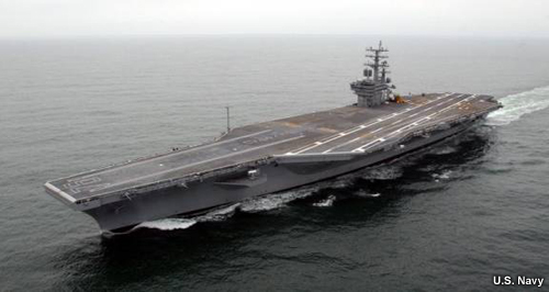
Photo of aircraft carrier Ronald Reagan (CVN76)
File Name:
cvn76.jpg
Credits:
U.S. Navy
Copyright Terms:
COMET Standard Terms
of Use
Description:
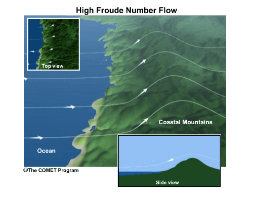
Conceptual animation depicting slowing and deflection of flow by as it crosses terrain in a stable atmosphere.
File Name:
high_froude.mp4
Credits:
©The COMET Program
Copyright Terms:
COMET Standard Terms
of Use
Description:
conceptual animation of landfalling front
File Name:
landfall.mp4
Credits:
©The COMET Program
Copyright Terms:
COMET Standard Terms
of Use
Description:
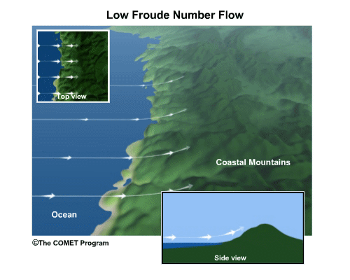
Conceptual animation depicting blocking and turning of flow by terrain in a stable atmosphere.
File Name:
low_froude.mp4
Credits:
©The COMET Program
Copyright Terms:
COMET Standard Terms
of Use
Description:
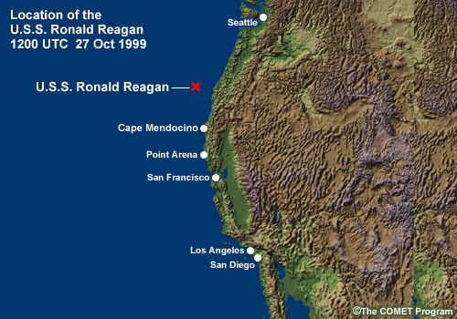
Shaded relief map of U.S. West Coast with location of U.S.S Ronald Reagan for module sceanrio.
File Name:
scenariomap1.jpg
Credits:
©The COMET Program
Copyright Terms:
COMET Standard Terms
of Use
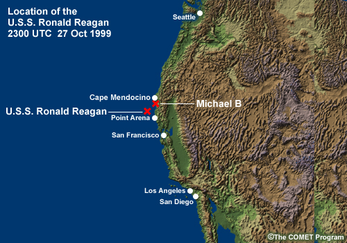
Description:
Shaded relief map of U.S. West Coast with location of U.S.S Ronald Reagan for module sceanrio at 2300 UTC 27 Oct 1999
File Name:
scenariomap2.jpg
Credits:
©The COMET Program
Copyright Terms:
COMET Standard Terms
of Use
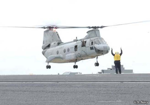
Description:
Sea Knight helicopter landing on the deck of an aircraft carrier
File Name:
seaknight.jpg
Credits:
U.S. Navy
Copyright Terms:
COMET Standard Terms
of Use

Description:
animation of schematic cross section highlighting the modification of the primary and secondary cold fronts and their attendant precipitation features by the blocked flow at times to, to + ?t, and to + 2?t (where ?t 3 h).
File Name:
splitfront_xs_01.jpg
Credits:
Neiman et al 2004
Copyright Terms:
COMET Standard Terms
of Use
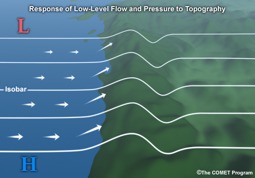
Description:
2-D conceptual figure showing the effect of flow blocking on isobars and coast-parallel flow
File Name:
wind_topo.jpg
Credits:
©The COMET Program
Copyright Terms:
COMET Standard Terms
of Use
Description:
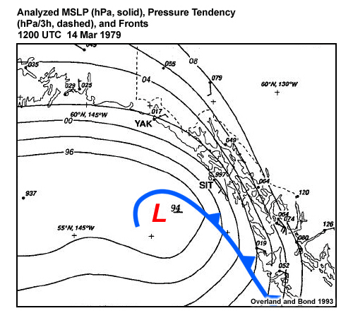
Analyzed MSLP (hPa, solid), Pressure Tendency (hPa/3h, dashed), and Fronts for the Yakutat Wind Storm 14 March 1979.
File Name:
yakutat_mslp_01.htm
Credits:
Overland and Bond 1993
Copyright Terms:
COMET Standard Terms
of Use
Description:
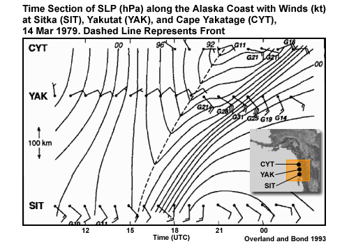
Time section of SLP (hPa) along the Alaska coast with winds (kt) at Sitka (SIT), Yakutat (YAK), and Cape Yakatage (CYT), 14 Mar 1979. Dashed line represents front.
File Name:
yakutata_slpwind.jpg
Credits:
Overland and Bond 1993
Copyright Terms:
COMET Standard Terms
of Use