Media elements used in this module are protected by a variety of copyright licenses. Please use the "copyright terms" link associated with each item below for more information.
Description:
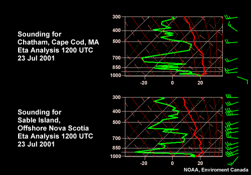
Soundings at Chatham, MA (Cape Cod) and Sable Island, NS (about 300 km offshore) 1200 UTC 23 Jul 2001
File Name:
12z23jul_soundings.gif
Credits:
NOAA, Environment Canada
Copyright Terms:
COMET Standard Terms
of Use
Description:
2 panel graphics of soundings from Chatham Ma and Sable Island
File Name:
12z23jul_soundings.gif
Credits:
NOAA/NCEP
Copyright Terms:
COMET Standard Terms
of Use
Description:
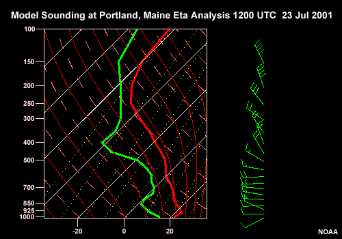
Model Sounding at Portalnd, Maine Eta Analysis 1200 UTC 23 Jul 2001
File Name:
2312pwms.gif
Credits:
NOAA
Copyright Terms:
COMET Standard Terms
of Use
Description:
Portland maine sounding for 23 Jul 2001 1200Z
File Name:
2312pwms.gif
Credits:
NOAA
Copyright Terms:
COMET Standard Terms
of Use
Description:
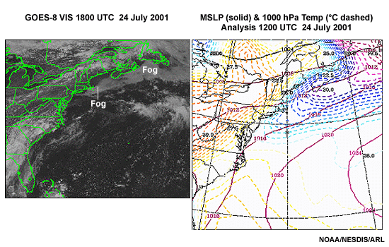
2-panel graphic with Vis imagery on left and corresponding Eta temp field on right
File Name:
24julfog.gif
Credits:
NOAA/NESDIS/ARL
Copyright Terms:
COMET Standard Terms
of Use
Description:
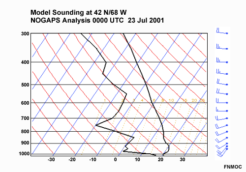
Model Sounding at 42 N/68 W (over Georges Bank, NW Atlantic Ocean) NOGAPS Analysis 0000 UTC 23 Jul 2001
File Name:
4268skew23jul00.gif
Credits:
FNMOC
Copyright Terms:
COMET Standard Terms
of Use
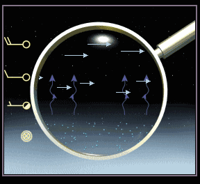
Description:
Conceptual diagram showing fog top maintenance processes: radiative cooling, droplet settling, and turbulent mixing.
File Name:
4bpix2.gif
Credits:
© The COMET Program
Copyright Terms:
COMET Standard Terms
of Use
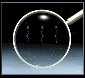
Description:
Conceptual diagram showing fogtop radiative cooling and droplet growth.
File Name:
4cpix1.gif
Credits:
© The COMET Program
Copyright Terms:
COMET Standard Terms
of Use
Description:
Conceptual diagram showing a low cloud layer just above a surface fog layer. Radiative cooling from the top of the cloud layer is greater than from the top of the fog layer.
File Name:
4fpix1.gif
Credits:
© The COMET Program
Copyright Terms:
COMET Standard Terms
of Use
Description:
Schematic showing growth of an overlying cloud layer above a surface fog layer during the daytime. As the cloud layer grows, less solar radiation reaches the surface, low-level weak convective mixing ceases and the fog layer deepens.
File Name:
4fpix1.gif
Credits:
© The COMET Program
Copyright Terms:
COMET Standard Terms
of Use
Description:
4 panel graphic of sample vetical model products useful in fog forecasting
File Name:
4panelvert_01.gif
Credits:
NCEP
Copyright Terms:
COMET Standard Terms
of Use
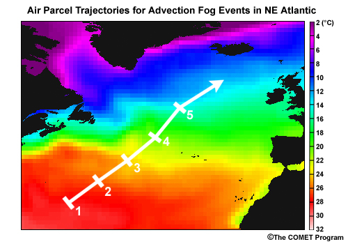
Description:
Northeast Atlantic SST with trajectory overlaid
File Name:
acfog_traj.jpg
Credits:
NASA / JPL / NOAA
Copyright Terms:
COMET Standard Terms
of Use
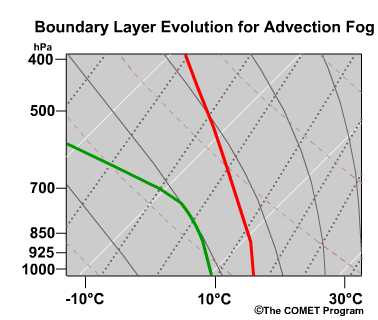
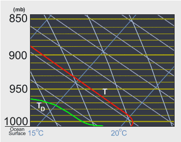
Description:
conceptual evolution of skew-t for an advection fog case
File Name:
adfog_skewt1.jpg
Credits:
©The COMET Program
Copyright Terms:
COMET Standard Terms
of Use
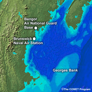
Description:
shaded relief map of New England and offshore areas showing the following: Bangor Air National Guard Base New Brunswick Naval Air Station Georges Bank - see attached map for location
File Name:
areamap1.jpg
Credits:
©The COMET Program
Copyright Terms:
COMET Standard Terms
of Use
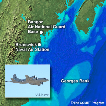
Description:
shaded relief map of New England and offshore areas showing the following: Bangor Air National Guard Base New Brunswick Naval Air Station P-3 Orion aircraft
File Name:
areamap1_p3.jpg
Credits:
U.S. Navy / The COMET Program
Copyright Terms:
COMET Standard Terms
of Use
Description:
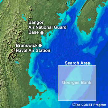
shaded relief map of New England and offshore areas showing the following: Bangor Air National Guard Base New Brunswick Naval Air Station P-3 Orion aircraft Search Area (for Scenario)
File Name:
areamap2.jpg
Credits:
U.S. Navy / The COMET Program
Copyright Terms:
COMET Standard Terms
of Use
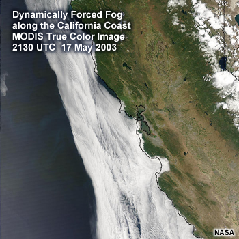
Description:
Dynamically-forced Fog Along the California Coast MODIS True Color Image 2130 UTC 23 May 2003
File Name:
ca_dynfog.jpg
Credits:
NASA
Copyright Terms:
COMET Standard Terms
of Use
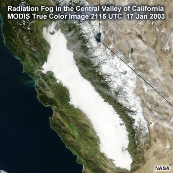
Description:
Radiation Fog in the Central Valley of California MODIS True Color Image 2115 UTC 17 Jan 2003
File Name:
ca_radfog.jpg
Credits:
NASA
Copyright Terms:
COMET Standard Terms
of Use
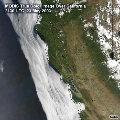
Description:
MODIS sat image over coastal california
File Name:
californiafog_1km.gif
Credits:
NASA
Copyright Terms:
COMET Standard Terms
of Use
Description:
map of california coast with air parcel trajectories
File Name:
californiamap.gif
Credits:
©The COMET Program
Copyright Terms:
COMET Standard Terms
of Use
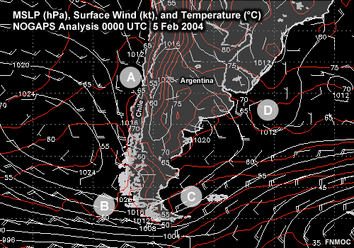
Description:
MSLP, surface wind (kt), and temperature ( C) over southern South America. NOGAPS Analysis 0000 UTC 5 Feb 2004
File Name:
chile_windtemp.gif
Credits:
FNMOC
Copyright Terms:
COMET Standard Terms
of Use
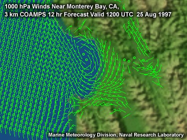
Description:
flash animation of coamps model1000 mb winds over coastal California
File Name:
coa1000wind0001.htm
Credits:
Marine Meteorology Division, Naval Research Laboratory
Copyright Terms:
COMET Standard Terms
of Use
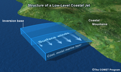
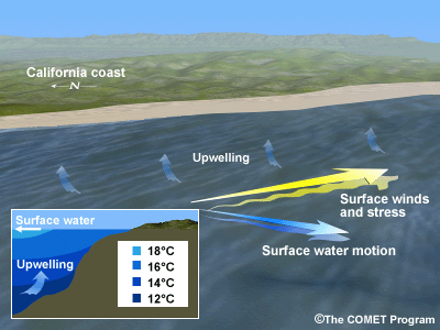
Description:
conceptual schematic of the structure of a coastal jet
File Name:
coastaljet_schematic.jpg
Credits:
©The COMET Program
Copyright Terms:
COMET Standard Terms
of Use
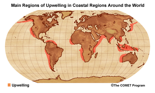
Description:
Upwelling regions around the world
File Name:
coastup2.gif
Credits:
©The COMET Program
Copyright Terms:
COMET Standard Terms
of Use
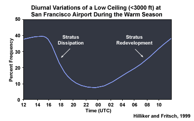
Description:
Diurnal variation of a low ceiling (<3000 ft) at SFO during the warm season
File Name:
daily.gif
Credits:
Clark and Wilson, 1996
Copyright Terms:
COMET Standard Terms
of Use
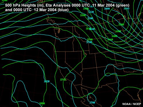
Description:
Eta 500 mb height changes
File Name:
dff500mb01.gif
Credits:
NOAA/NCEP
Copyright Terms:
COMET Standard Terms
of Use
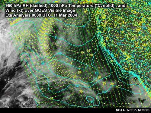
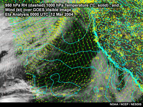
Description:
eta 212 950 Rh, 1000 mb temps and winds with vis image overlaid
File Name:
dffav01.gif
Credits:
NOAA/NCEP/NESDIS
Copyright Terms:
COMET Standard Terms
of Use
Description:
eta 212 950 Rh, 1000 mb temps and winds with vis image overlaid
File Name:
dffav03.gif
Credits:
NOAA/NCEP/NESDIS
Copyright Terms:
COMET Standard Terms
of Use
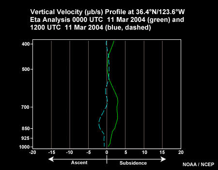
Description:
Eta Omega vertical cross sections
File Name:
dffetaomg01.gif
Credits:
NOAA/NCEP
Copyright Terms:
COMET Standard Terms
of Use
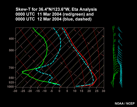
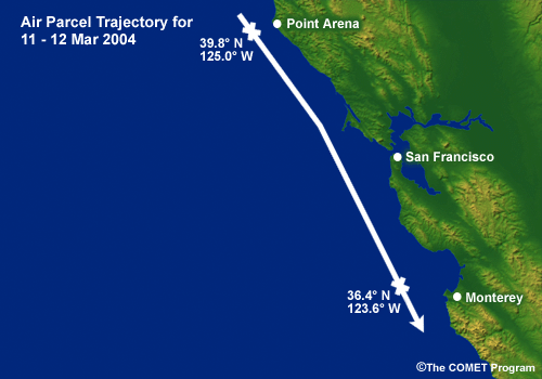
Description:
eta 212 sounding for 0000 UTC 11 and 12 Mar 2003
File Name:
dffetasnd01.gif
Credits:
NOAA/NCEP
Copyright Terms:
COMET Standard Terms
of Use
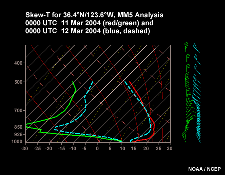
Description:
MM5 sounding for 0000 UTC 11 and 12 Mar 2003
File Name:
dffmm5snd01.gif
Credits:
NOAA/NCEP
Copyright Terms:
COMET Standard Terms
of Use
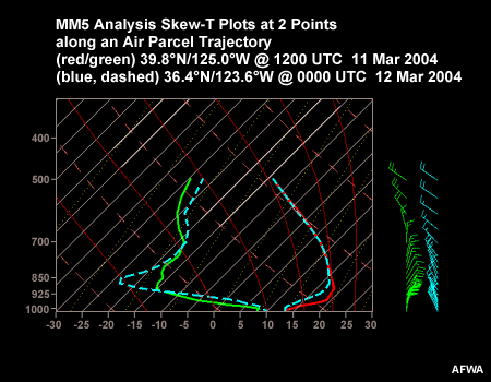
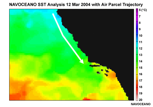
Description:
MM5 sounding for 0000 UTC 12 Mar 2004 and 1200UTC 11Mar 2004 for two different locations
File Name:
dffmm5traj01.gif
Credits:
AFWA
Copyright Terms:
COMET Standard Terms
of Use
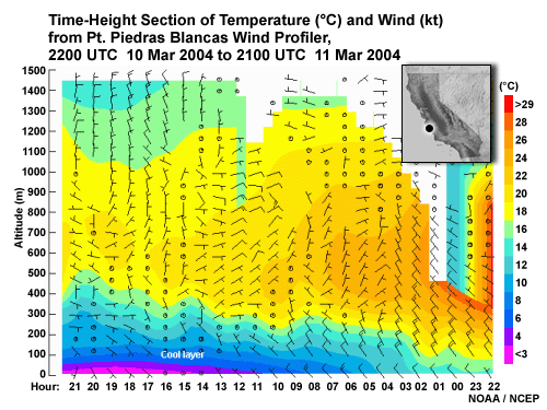
Description:
profiler cross section from Piedras blancas profiler
File Name:
dffppb915.gif
Credits:
NOAA/NCEP
Copyright Terms:
COMET Standard Terms
of Use
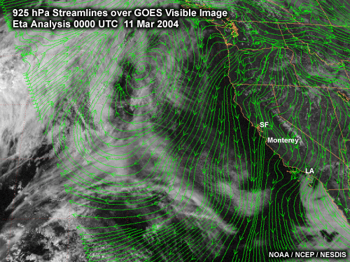
Description:
Eta 925mb winds with visible sat image overlaid
File Name:
dffvis925mb01.gif
Credits:
NOAA/NCEP/NESDIS
Copyright Terms:
COMET Standard Terms
of Use
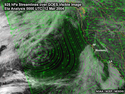
Description:
Eta 925mb winds with visible sat image overlaid
File Name:
dffvis925mb03.gif
Credits:
NOAA/NCEP/NESDIS
Copyright Terms:
COMET Standard Terms
of Use
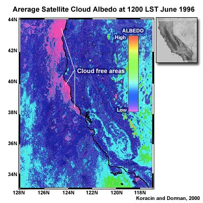
Description:
Average satellite cloud albedo image to go with model simualtions and measurements of coastal divergence and convergence over coastal california
File Name:
divconimage.jpg
Credits:
Koracin and Dorman 2000
Copyright Terms:
COMET Standard Terms
of Use
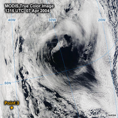
Description:
4km visible modis image over east atlantic for 07april 2004 1315UTC
File Name:
eatlcmodis071315.gif
Credits:
NASA
Copyright Terms:
COMET Standard Terms
of Use
Description:
from west coast fog
File Name:
ekman2.gif
Credits:
©The COMET Program
Copyright Terms:
COMET Standard Terms
of Use
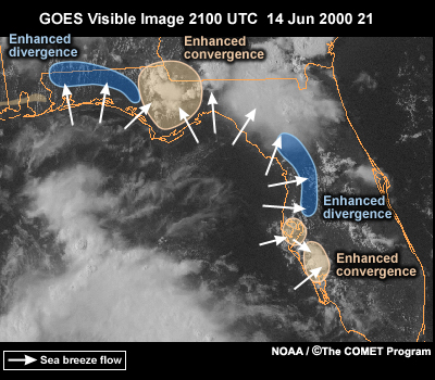
Description:
GOES 8 vis image over florida showing convergent/ divergent regions
File Name:
floridacst.jpg
Credits:
NOAA/NGDC/The COMET Program
Copyright Terms:
COMET Standard Terms
of Use
Description:
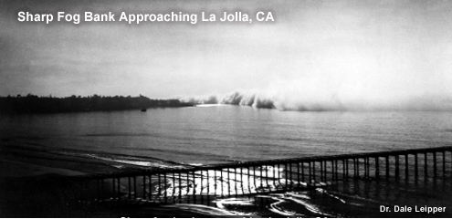
Photo of sea fogbank offshore
File Name:
fogbank.jpg
Credits:
Dr. Dale Leipper
Copyright Terms:
COMET Standard Terms
of Use
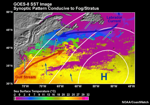
Description:
GOES-8 SST image with area of scenario search area.
File Name:
goessst.gif
Credits:
NOAA / Coast Watch
Copyright Terms:
COMET Standard Terms
of Use
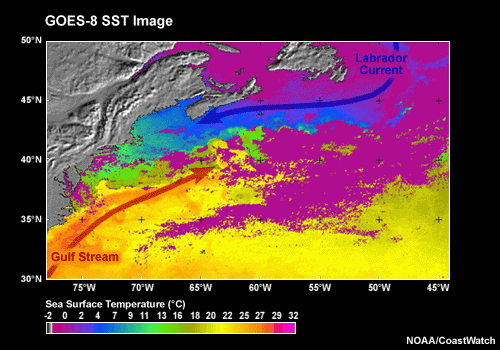
Description:
SST patterns, Labrador and Gulf stream currents
File Name:
goessst.gif
Credits:
NOAA/CoastWatch
Copyright Terms:
COMET Standard Terms
of Use
Description:
File Name:
hazeform.gif
Credits:
© The COMET Program
Copyright Terms:
COMET Standard Terms
of Use
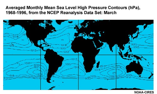
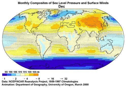
Description:
animation of global MSL patterns for March, June, September and December
File Name:
hipres0001.htm
Credits:
NOAA-CIRES
Copyright Terms:
COMET Standard Terms
of Use
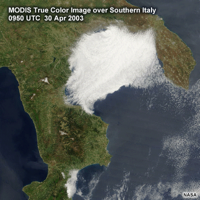
Description:
MODIS true color image over southern Italy 0950 UTC 30 Apr 2003
File Name:
italyfog.gif
Credits:
NASA
Copyright Terms:
COMET Standard Terms
of Use
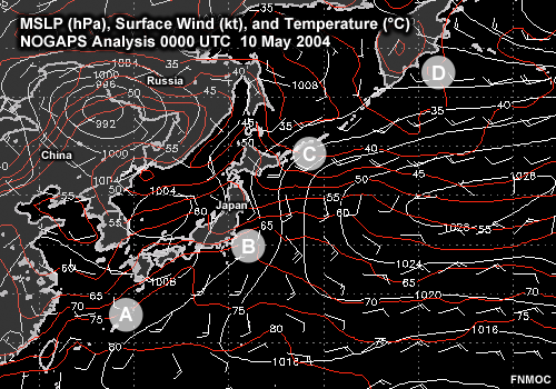
Description:
MSLP (hPa), surface wind (kt), and temperature ( C) over the western Pacific and eastern Asia. NOGAPS Analysis 0000 UTC 10 May 2004
File Name:
japan_windtemp.gif
Credits:
FNMOC
Copyright Terms:
COMET Standard Terms
of Use
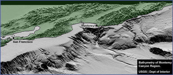
Description:
Shaded oblique bathymetry of central California coast from San Francisco to Big Sur
File Name:
mb_bath.gif
Credits:
USGS
Copyright Terms:
COMET Standard Terms
of Use
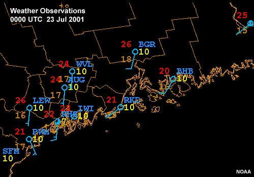
Description:
Weather observations along the coast of Maine 0000 UTC to 1000 UTC 23 Jul 2001
File Name:
metars23jul010001.htm
Credits:
NOAA
Copyright Terms:
COMET Standard Terms
of Use
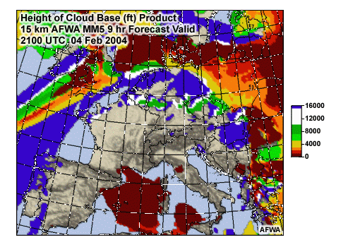
Description:
MM5 cloud product over the Mediterranean
File Name:
mm5cloudprod.gif
Credits:
AFWA
Copyright Terms:
COMET Standard Terms
of Use
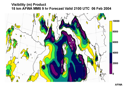
Description:
MM5 visibility product over the Mediterranean
File Name:
mm5visprod.gif
Credits:
AFWA
Copyright Terms:
COMET Standard Terms
of Use
Description:
File Name:
moisten.gif
Credits:
© The COMET Program
Copyright Terms:
COMET Standard Terms
of Use
Description:
conceptual animation of skew-t evolution for advection fog development
File Name:
moisten.gif
Credits:
©The COMET Program
Copyright Terms:
COMET Standard Terms
of Use
Description:
flash animation of the annual global winds and pressure changes
File Name:
mslpwinds0001.htm
Credits:
NCEP/NCAR and University of Oregon
Copyright Terms:
COMET Standard Terms
of Use
Description:
NOGAPS MSL and wind analyses
File Name:
nogaps_msl_01.gif
Credits:
FNMOC
Copyright Terms:
COMET Standard Terms
of Use
Description:
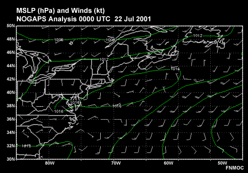
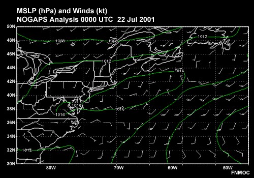
MSLP (hPa) and Winds (kt) over the Eastern U.S. and offshore over the NW Atlantic Ocean NOGAPS Analyses: 0000 UTC 22 Jul 2001 1200 UTC 22 Jul 2001 0000 UTC 23 Jul 2001 1200 UTC 23 Jul 2001
File Name:
nogaps_msl0001.htm
Credits:
FNMOC
Copyright Terms:
COMET Standard Terms
of Use
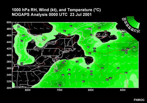
Description:
1000 hPa RH, Wind (kt), and Temperature ( C) over the Atalntic Ocean adjacent to the Northeast U.S. NOGAPS Analysis 0000 UTC 23 Jul 2001
File Name:
nogaps1000temprhwind.gif
Credits:
FNMOC
Copyright Terms:
COMET Standard Terms
of Use
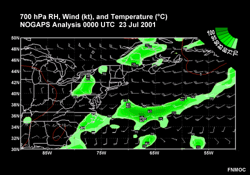
Description:
700 hPa RH, Wind (kt), and Temperature ( C) over the Atalntic Ocean adjacent to the Northeast U.S. NOGAPS Analysis 0000 UTC 23 Jul 2001
File Name:
nogaps700temprhwind.gif
Credits:
FNMOC
Copyright Terms:
COMET Standard Terms
of Use
Description:
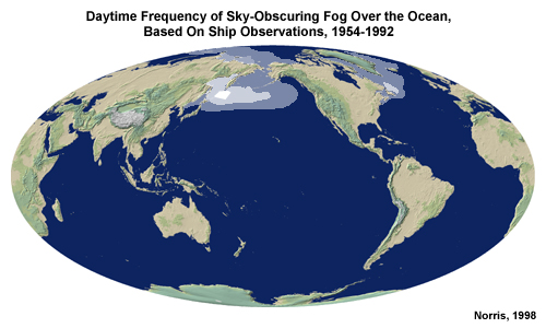
Climatological Jun-Jul-Aug (top) and Dec-Jan-Feb (bottom) daytime frequency of sky-obscuring fog over the ocean based on ship observations from 1954-1992.
File Name:
ocean_fog_1.jpg
Credits:
Norris, 1998
Copyright Terms:
COMET Standard Terms
of Use
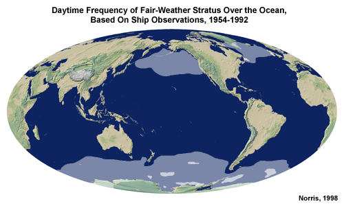
Description:
Daytime frequency of fair-weather stratus over the ocean, based on ship observations, 1954-1992. Jun-Jul-Aug and Dec-Jan-Feb
File Name:
ocean_stratus_dec-feb.jpg
Credits:
Norris, 1998
Copyright Terms:
COMET Standard Terms
of Use
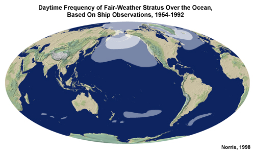
Description:
Daytime frequency of fair-weather stratus over the ocean, based on ship observations, 1954-1992. Jun-Jul-Aug and Dec-Jan-Feb
File Name:
ocean_stratus_jun-aug.jpg
Credits:
Norris, 1998
Copyright Terms:
COMET Standard Terms
of Use
Description:
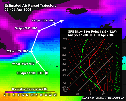
Skew-t for point 1 along trajectory along with trajectory map
File Name:
pt1skewt.gif
Credits:
NASA / JPL / NOAA
Copyright Terms:
COMET Standard Terms
of Use
Description:
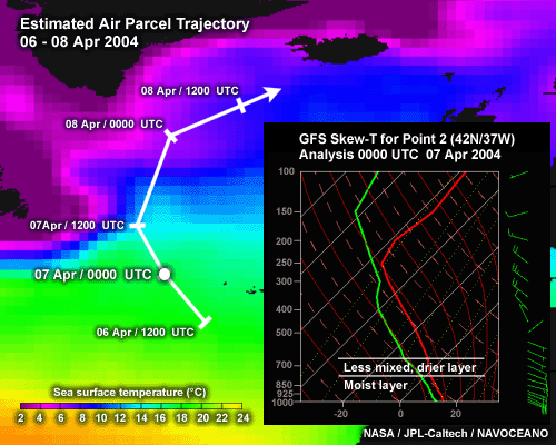
Skew-t for point 2 along trajectory along with trajectory map
File Name:
pt2skewt.gif
Credits:
NASA / JPL / NOAA
Copyright Terms:
COMET Standard Terms
of Use
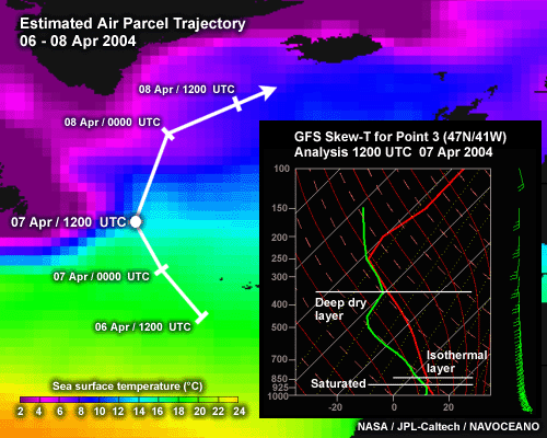
Description:
Skew-t for point 3 along trajectory along with trajectory map
File Name:
pt3skewt.gif
Credits:
NASA / JPL / NOAA
Copyright Terms:
COMET Standard Terms
of Use
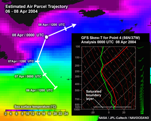
Description:
Skew-t for point 4 along trajectory along with trajectory map
File Name:
pt4skewt.gif
Credits:
NASA / JPL / NOAA
Copyright Terms:
COMET Standard Terms
of Use
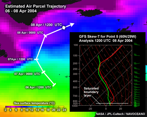
Description:
Skew-t for point 5 along trajectory along with trajectory map
File Name:
pt5skewt.gif
Credits:
NASA / JPL / NOAA
Copyright Terms:
COMET Standard Terms
of Use
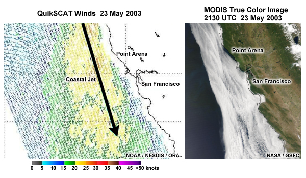
Description:
2 panel graphic of quikscat and modis images over california coast showing fog event
File Name:
quikscat_modis.jpg
Credits:
NASA/Goddard
Copyright Terms:
COMET Standard Terms
of Use
Description:
flash animation of seabreeze affect on fog over california coast from GOEs-10 vis imagery
File Name:
seabreeze13p30001.htm
Credits:
NOAA
Copyright Terms:
COMET Standard Terms
of Use
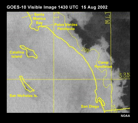
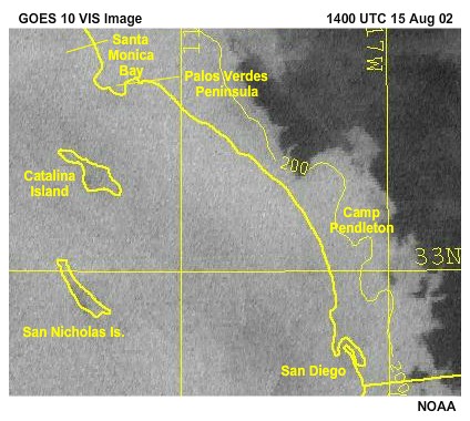
Description:
GOES 10 vis image of fog over california coast
File Name:
seabreezefog.jpg
Credits:
NOAA
Copyright Terms:
COMET Standard Terms
of Use
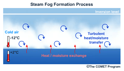
Description:
conceptual animation of steam fog development
File Name:
seasmoke.mp4
Credits:
©The COMET Program
Copyright Terms:
COMET Standard Terms
of Use
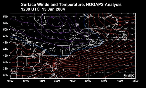
Description:
NOGAPS surface winds and temperature for 12 15 jan 2004 and 00 and 12 UTC 16 jan 2004
File Name:
sfcwindtemp0001.htm
Credits:
FNMOC
Copyright Terms:
COMET Standard Terms
of Use
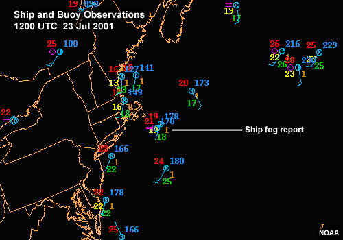
Description:
Weather observations from ships and buoys offshore of the northeastern U.S. 1200 UTC 23 Jul 2001
File Name:
shipbuoy12z23jul01.gif
Credits:
NOAA
Copyright Terms:
COMET Standard Terms
of Use
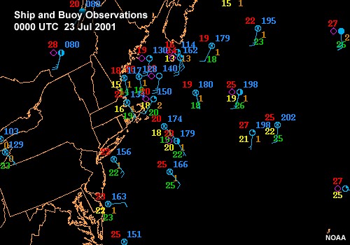
Description:
Weather observations from ships and buoys offshore of the northeastern U.S. 0000 UTC to 1000 UTC 23 Jul 2001
File Name:
shipbuoy23jul010001.htm
Credits:
NOAA
Copyright Terms:
COMET Standard Terms
of Use
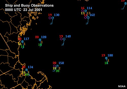
Description:
Weather observations from ships and buoys offshore of the northeastern U.S. in the Gulf of Maine 0000 UTC to 1000 UTC 23 Jul 2001
File Name:
shipbuoylocal23jul010001.htm
Credits:
NOAA
Copyright Terms:
COMET Standard Terms
of Use
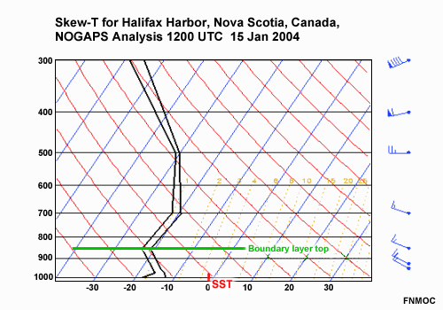
Description:
NOGAPS Skewt profile over Halifax harbor for 1200 UTC 15 january 2004
File Name:
skewt_15jan12_swns.gif
Credits:
FNMOC
Copyright Terms:
COMET Standard Terms
of Use
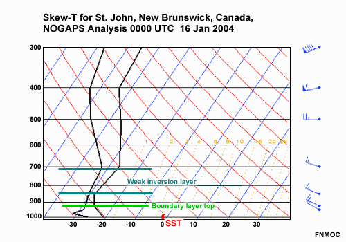
Description:
NOGAPS Skew-t for St. John New brunswick
File Name:
skewt_16jan00_stjohn.gif
Credits:
FNMOC
Copyright Terms:
COMET Standard Terms
of Use
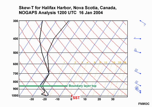
Description:
NOGAPS Skew-t for Halifax harbor
File Name:
skewt_16jan12.gif
Credits:
FNMOC
Copyright Terms:
COMET Standard Terms
of Use
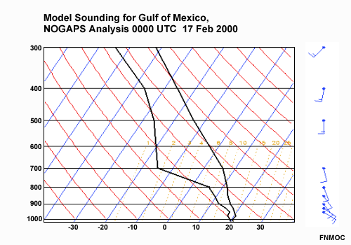
Description:
NOGAPS skew-t example over the Gulf of Mexico
File Name:
skewtpt6_1700.gif
Credits:
FNMOC
Copyright Terms:
COMET Standard Terms
of Use
Description:
animation of MSLP and temperature grids from Eta model
File Name:
slptmp0001.htm
Credits:
NOAA/NCEP
Copyright Terms:
COMET Standard Terms
of Use
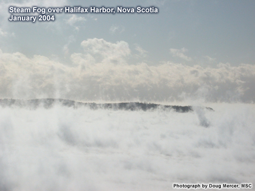
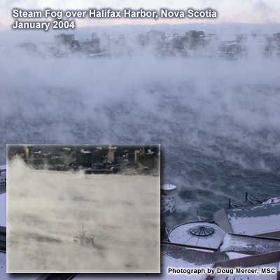
Description:
photo of steam fog in halifax harbor
File Name:
smoke6.jpg
Credits:
MSC
Copyright Terms:
COMET Standard Terms
of Use
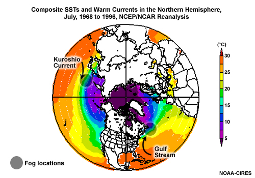
Description:
July SST patterns and warm ocean currents over the northern Hemisphere
File Name:
sst_current.jpg
Credits:
NOAA-CIRES
Copyright Terms:
COMET Standard Terms
of Use
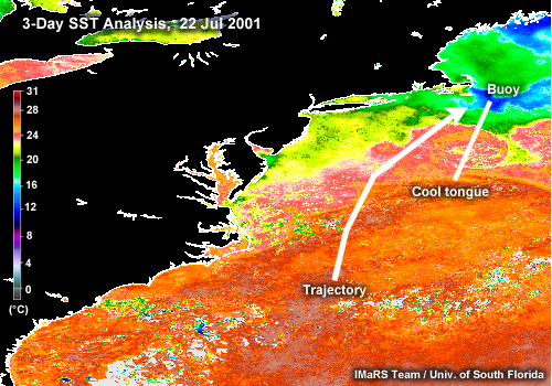
Description:
SST 3 day analysis composite for July 22 2001
File Name:
sst22jul.jpg
Credits:
Univ. of Southern Florida
Copyright Terms:
COMET Standard Terms
of Use
Description:
sst map off california with air trajectory overlaid
File Name:
sstmar2004.gif
Credits:
NASA / JPL-Caltech / NAVOCEANO
Copyright Terms:
COMET Standard Terms
of Use
Description:
SST pattern and currents over nw atlantic
File Name:
sstwxptn.gif
Credits:
NOAA/CoastWatch
Copyright Terms:
COMET Standard Terms
of Use
Description:
2 panel graphic of photos of steam fog over halifax harbor
File Name:
steam_panel.jpg
Credits:
Meteorological Services Canada
Copyright Terms:
COMET Standard Terms
of Use
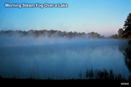
Description:
photo of steam fog over a lake
File Name:
steamfog_lake.gif
Credits:
NOAA
Copyright Terms:
COMET Standard Terms
of Use
Description:
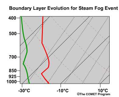
animation showing conceptual evolution of bondary layer on a skew-t for a steam fog case
File Name:
steamfog_skewt1.jpg
Credits:
©The COMET Program
Copyright Terms:
COMET Standard Terms
of Use
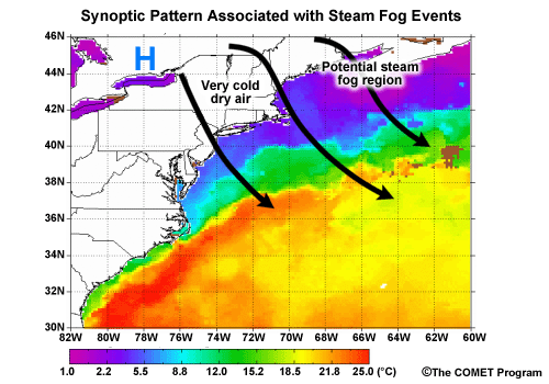
Description:
Synoptic conditions associated with steam fog over NW Atlantic
File Name:
steamfog_synoptics.gif
Credits:
©The COMET Program
Copyright Terms:
COMET Standard Terms
of Use
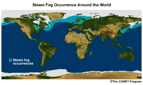
Description:
Global steam fog regions
File Name:
steamfoglocations.gif
Credits:
©The COMET Program
Copyright Terms:
COMET Standard Terms
of Use
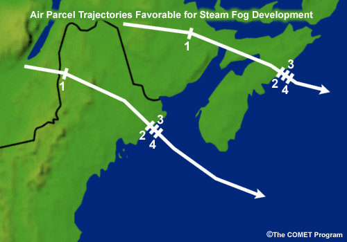
Description:
Chart showing air parcel trajectories favorable for steam fog development
File Name:
stmfog_traj.gif
Credits:
©The COMET Program
Copyright Terms:
COMET Standard Terms
of Use
Description:
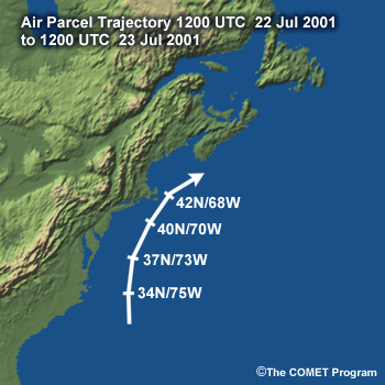
Airparcel trajectory for 12 UTC 22 Jul 2001 along the eastern seaboard of the US from near Cape Hatteras to Nova Scotia
File Name:
trajectorymap.jpg
Credits:
©The COMET Program
Copyright Terms:
COMET Standard Terms
of Use
Description:
air parcel trajectory map for NW atlantic case
File Name:
trajectorymap.jpg
Credits:
©The COMET Program
Copyright Terms:
COMET Standard Terms
of Use
Description:
skew t series along the air parcel trajectory
File Name:
trajskewts_01.gif
Credits:
FNMOC DET Asheville
Copyright Terms:
COMET Standard Terms
of Use
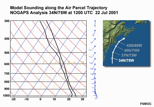
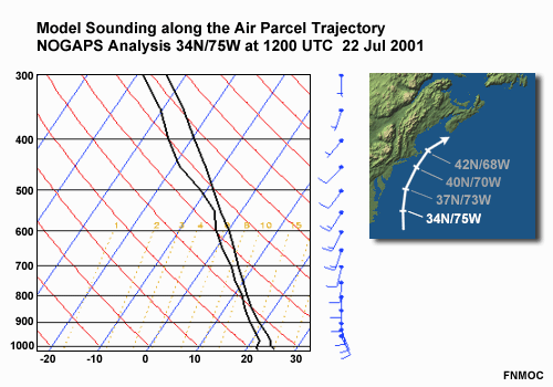
Description:
model soundings along an air parcel trajectory along the eastern seaboard of the US. NOGAPS Analyses: 34N/75W at 1200 UTC 22 Jul 2001 37N/73W at 0000 UTC 23 Jul 2001 40N/70W at 1200 UTC 23 Jul 2001 42N/68W at 1200 UTC 23 Jul 2001
File Name:
trajskewts0001.htm
Credits:
FNMOC
Copyright Terms:
COMET Standard Terms
of Use
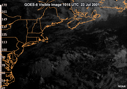
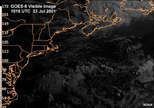
Description:
GOES-8 Visible Image over the Atlantic Ocean east of the Northeast U.S. 1015 UTC 23 Jul 2001
File Name:
vis02.gif
Credits:
NOAA
Copyright Terms:
COMET Standard Terms
of Use
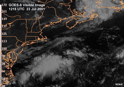
Description:
GOES-8 Visible Images over the Atlantic Ocean east of the Northeast U.S. 1015 UTC to 1215 UTC 23 Jul 2001
File Name:
vis02_040001.htm
Credits:
NOAA
Copyright Terms:
COMET Standard Terms
of Use
Description:
GOES-8 Visible Images over the Atlantic Ocean east of the Northeast U.S. 1215 UTC to 1415 UTC 23 Jul 2001
File Name:
vis04_060001.htm
Credits:
NOAA
Copyright Terms:
COMET Standard Terms
of Use
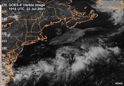
Description:
GOES-8 Visible Images over the Atlantic Ocean east of the Northeast U.S. 1915 UTC 23 Jul 2001
File Name:
vis10.gif
Credits:
NOAA
Copyright Terms:
COMET Standard Terms
of Use
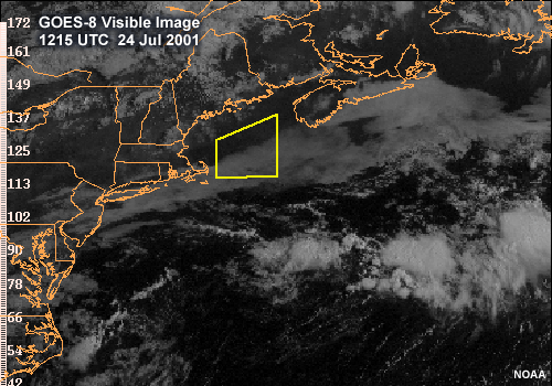
Description:
GOES-8 Visible Images over the Atlantic Ocean east of the Northeast U.S. 1215 UTC 24 Jul 2001
File Name:
vis18.gif
Credits:
NOAA
Copyright Terms:
COMET Standard Terms
of Use
Description:
2 panel visibile imagery over northwest atlantic
File Name:
viszoom1200.gif
Credits:
NOAA/NESDIS
Copyright Terms:
COMET Standard Terms
of Use
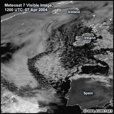
Description:
Visible fog image over NE Atlantic with labels
File Name:
viszoom1200.gif
Credits:
© 2004, EUMETSAT
Copyright Terms:
COMET Standard Terms
of Use
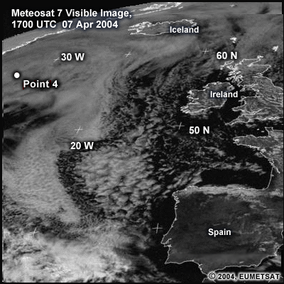
Description:
Meteosat 7 visible image for 1700 UTC 07Apr 2004 over east atlantic
File Name:
viszoom1700.gif
Credits:
© 2004, EUMETSAT
Copyright Terms:
COMET Standard Terms
of Use
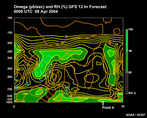
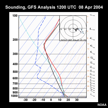
Description:
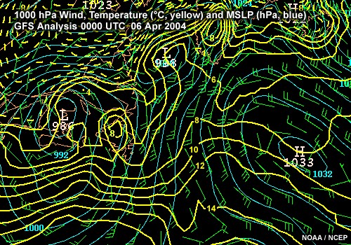
00HR AVN omega (ub/sec) and RH(%). Valid: 0000 UTC 08 Apr 2004
File Name:
vvrhxs01.gif
Credits:
NOAA/NCEP
Copyright Terms:
COMET Standard Terms
of Use
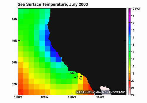
Description:
Sea Surface Temperature along the U.S. West Coast July 2003
File Name:
wc_sst_jul2003.png
Credits:
NASA / JPL / NOAA
Copyright Terms:
COMET Standard Terms
of Use
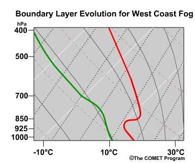
Description:
conceptual evolution of skew-t for a west coast fog case
File Name:
wcfog_skewt1.jpg
Credits:
©The COMET Program
Copyright Terms:
COMET Standard Terms
of Use
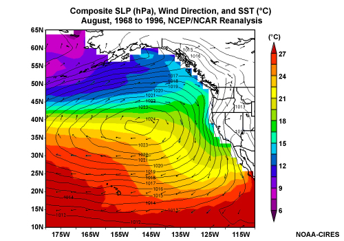
Description:
Composite SLP, Winds, and SSTs over the northeast Pacific Ocean for the month of August, 1968 to 1996, from the NCEP/NCAR Reanalysis
File Name:
wcfog_synoptic.jpg
Credits:
NOAA-CIRES
Copyright Terms:
COMET Standard Terms
of Use
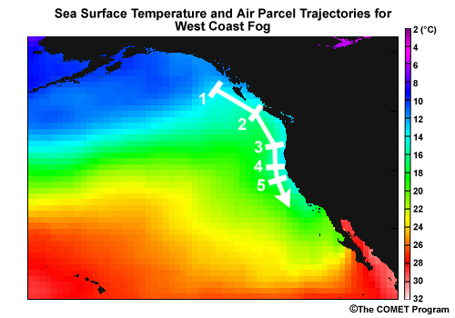
Description:
West coast fog trajectories
File Name:
wcfog_traj.jpg
Credits:
NASA / JPL / NOAA
Copyright Terms:
COMET Standard Terms
of Use
Description:
West coast l fog trajectories
File Name:
wcfog_traj.jpg
Credits:
©The COMET Program
Copyright Terms:
COMET Standard Terms
of Use
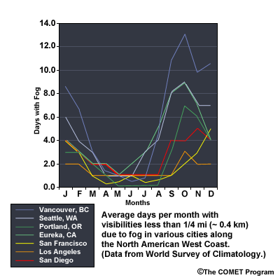
Description:
West coast l fog frequency graph
File Name:
wcfogavg.gif
Credits:
©The COMET Program
Copyright Terms:
COMET Standard Terms
of Use
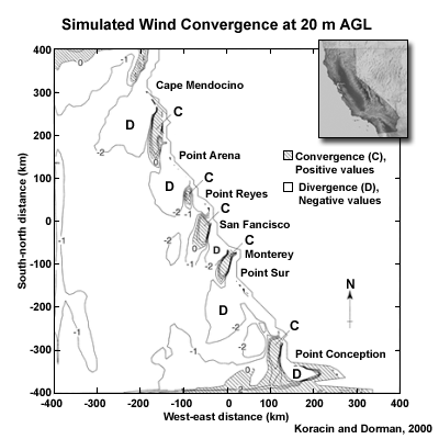
Description:
model simulations and measurements of coastal divergence and convergence over coastal california
File Name:
windiv_a.gif
Credits:
Koracin and Dorman 2000
Copyright Terms:
COMET Standard Terms
of Use
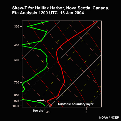
Description:
Eta Skew-t for Halifax harbor
File Name:
yhz1612.gif
Credits:
NOAA/NCEP
Copyright Terms:
COMET Standard Terms
of Use