Media elements used in this module are protected by a variety of copyright licenses. Please use the "copyright terms" link associated with each item below for more information.

Description:
MODIS image of sea surface temperature over the Arabian Sea showing cold temperatures along the coast of Oman due to upwelling. 25 May 2003
File Name:
arabian_sst.gif
Credits:
NASA
Copyright Terms:
COMET Standard Terms
of Use
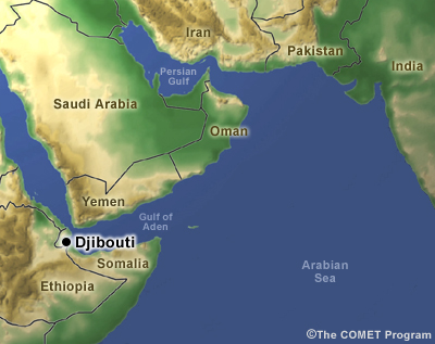
Description:
shaded relief map of Arabian sea with locations used in script
File Name:
arabiansea.jpg
Credits:
©The COMET Program
Copyright Terms:
COMET Standard Terms
of Use
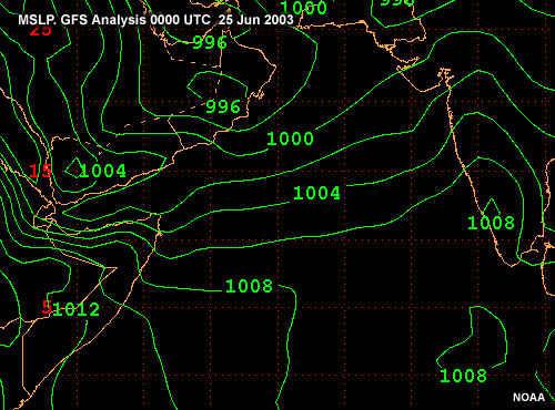
Description:
MSLP forecast over the Arabian Sea. GFS forecast 0000 UTC 25 Jun 2003 to 0000 UTC 27 Jun 2003
File Name:
arabsea_mslp_01.gif
Credits:
NOAA
Copyright Terms:
COMET Standard Terms
of Use
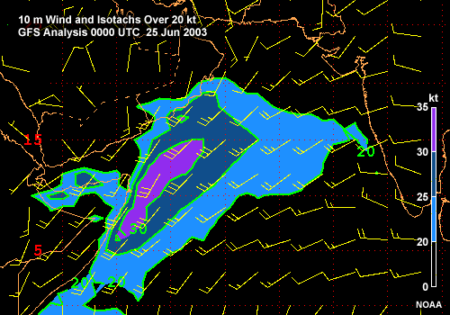
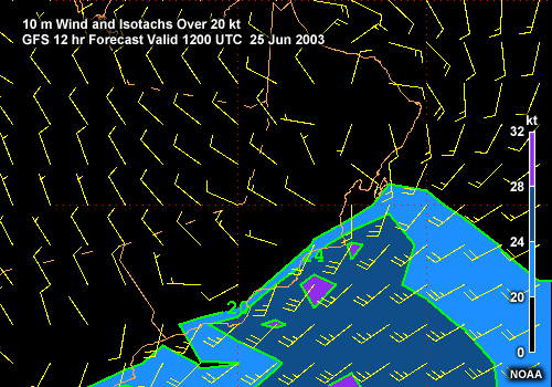
Description:
Wind and Isotachs over 20 kt over the Arabian Sea. GFS forecast 0000 UTC 25 Jun 2003 to 0000 UTC 27 Jun 2003
File Name:
arabsea_wind_01.gif
Credits:
NOAA
Copyright Terms:
COMET Standard Terms
of Use
Description:
3-d oblique view of the California coast that emphasizes the coastal mountains, with heating over the central valley and winds that slow slightly near the surface
File Name:
ca.jpg
Credits:
©The COMET Program
Copyright Terms:
COMET Standard Terms
of Use
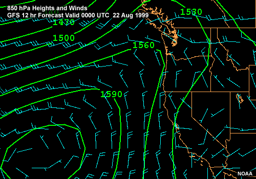
Description:
850 hPa heights and winds over California and adjacent Pacific Ocean. Eta 12-hr forecast valid 00 UTC 22 Aug 1999
File Name:
ca_850.gif
Credits:
NOAA
Copyright Terms:
COMET Standard Terms
of Use

Description:
MSLP over CA and adjacent ocean. MM5 12-hr forecast valid 0000 UTC 22 Aug 99
File Name:
ca_mm5_mslp_05.gif
Credits:
Naval Postgraduate School
Copyright Terms:
COMET Standard Terms
of Use
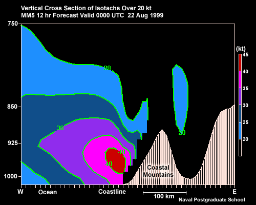
Description:
Vertical cross section of isotachs over 20 kt across the California coast during a coastal jet event. MM5 12-hr forecast valid 00 UTC 22 Aug 99
File Name:
ca_mm5_xs_isotachs.gif
Credits:
Naval Postgraduate School
Copyright Terms:
COMET Standard Terms
of Use
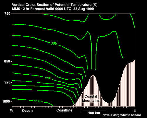
Description:
Vertical cross section of potential temperature across the California coast during a coastal jet event. MM5 12-hr forecast valid 00 UTC 22 Aug 99
File Name:
ca_mm5_xs_theta.gif
Credits:
Naval Postgraduate School
Copyright Terms:
COMET Standard Terms
of Use
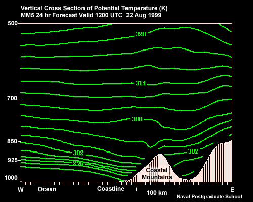
Description:
Vertical cross section of potential temperature across the California coast during a coastal jet event. MM5 24-hr forecast valid 12 UTC 22 Aug 99
File Name:
ca_mm5_xs2_theta.gif
Credits:
Naval Postgraduate School
Copyright Terms:
COMET Standard Terms
of Use
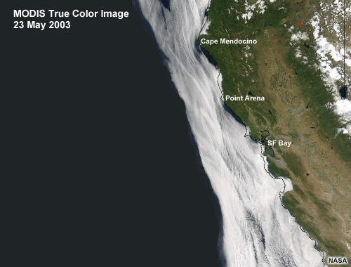
Description:
MODIS True Color Image along the California Coast, 23 May 2003
File Name:
ca_modis.gif
Credits:
NASA
Copyright Terms:
COMET Standard Terms
of Use
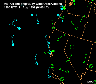
Description:
METAR and Ship/Buoy Wind Observations along the west coast of the U.S. showing persistent strong along-shore winds in the offshore area. 1200 UTC 21 Aug 1999 to 1200 UTC 22 Aug 1999
File Name:
ca_obs_01.gif
Credits:
NOAA
Copyright Terms:
COMET Standard Terms
of Use

Description:
Quikscat satellite-derived winds along California coast, 23 May 2003
File Name:
ca_qscat.gif
Credits:
NASA
Copyright Terms:
COMET Standard Terms
of Use
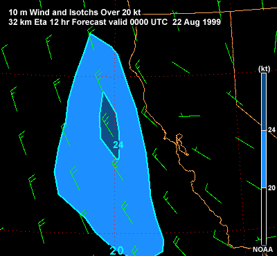
Description:
10-m Wind and Isotachs over 20 kt along the California Coast 32-km Eta 12-hr forecast valid 0000 UTC 22 Aug 1999
File Name:
ca_wind_isotachs_eta.gif
Credits:
NOAA
Copyright Terms:
COMET Standard Terms
of Use
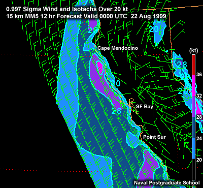
Description:
0.997-sigma Wind and Isotachs over 20 kt along the California Coast 15-km MM5 12-hr forecast valid 0000 UTC 22 Aug 1999
File Name:
ca_wind_isotachs_mm5.gif
Credits:
Naval Postgraduate School
Copyright Terms:
COMET Standard Terms
of Use
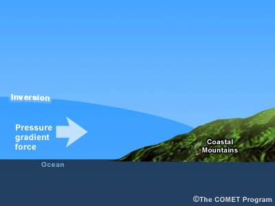
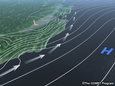
Description:
conceptual cross section showing ocean, coastal mountains, marineboundary layer capped by strong inversion, and coastward-directed pressure gradient force
File Name:
channel_xs.gif
Credits:
©The COMET Program
Copyright Terms:
COMET Standard Terms
of Use
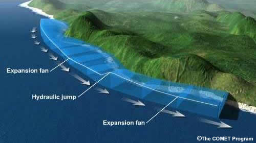
Description:
Animation of flow down a coastline showing expansion fan and hydraulic jump
File Name:
channelflow.jpg
Credits:
©The COMET Program
Copyright Terms:
COMET Standard Terms
of Use
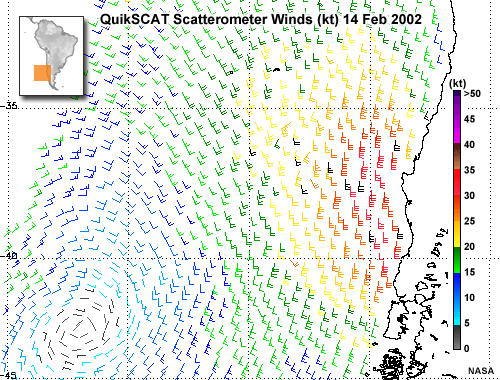
Description:
Quikscat satellite-derived winds off Chile, 14-Feb-2002
File Name:
chile_qscat.gif
Credits:
NASA
Copyright Terms:
COMET Standard Terms
of Use
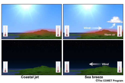
Description:
side-by-side comparison of seabreeze versus coastal jet
File Name:
coastajet_seabreeze.gif
Credits:
©The COMET Program
Copyright Terms:
COMET Standard Terms
of Use
Description:
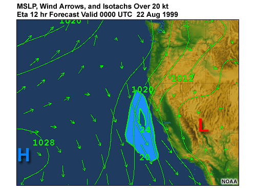
Wind arrows, isotachs over 20 kt, and MSLP for Eastern Pacific and US West Coast. Eta 12 hr Forecast Valid 0000 UTC 22 Aug 1999
File Name:
coastaljet.gif
Credits:
NOAA
Copyright Terms:
COMET Standard Terms
of Use
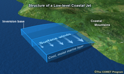
Description:
Schematic image of the coastal jet
File Name:
coastaljet_schematic.jpg
Credits:
©The COMET Program
Copyright Terms:
COMET Standard Terms
of Use
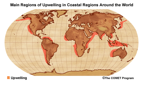
Description:
Main regions of upwelling in coastal regions around the world
File Name:
coastup2.png
Credits:
©The COMET Program
Copyright Terms:
COMET Standard Terms
of Use
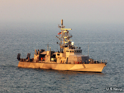
Description:
photo of a Cyclone-class Coastal Patrol boat
File Name:
cyclone.jpg
Credits:
U.S. Navy
Copyright Terms:
COMET Standard Terms
of Use
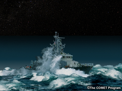
Description:
Photograph of wave striking a Cyclone-class Patrol Boat
File Name:
cyclone_wave.jpg
Credits:
©The COMET Program
Copyright Terms:
COMET Standard Terms
of Use
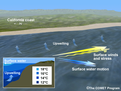
Description:
Schematic showing the relationship between surface wind, surface water movement, and upwelling
File Name:
ekman2.gif
Credits:
©The COMET Program
Copyright Terms:
COMET Standard Terms
of Use
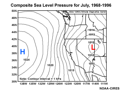
Description:
Composite sea level pressure for the month of July over the western US and Eastern Pacific, 1968-1996
File Name:
july_slp.gif
Credits:
NOAA-CIRES-CDC
Copyright Terms:
COMET Standard Terms
of Use
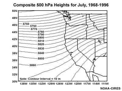
Description:
Composite 500-mb heights for the month of July over the western US and Eastern Pacific, 1968-1996
File Name:
july500ht.gif
Credits:
NOAA-CIRES-CDC
Copyright Terms:
COMET Standard Terms
of Use
Description:
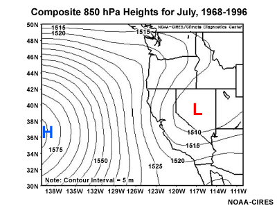
Composite 850-mb heights for the month of July over the western US and Eastern Pacific, 1968-1996
File Name:
july850ht.gif
Credits:
NOAA-CIRES-CDC
Copyright Terms:
COMET Standard Terms
of Use
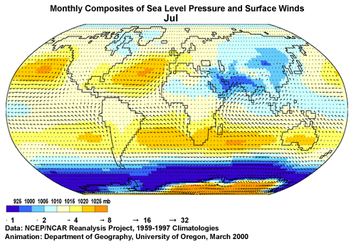
Description:
looping monthly composites of MSLP and surfacec wind.
File Name:
mslpwinds1_08.gif
Credits:
University of Oregon
Copyright Terms:
COMET Standard Terms
of Use

Description:
World map showing major cold ocean currents
File Name:
ocean_currents.gif
Credits:
©The COMET Program
Copyright Terms:
COMET Standard Terms
of Use
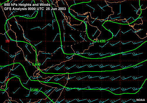
Description:
850 hPa heights and winds over the NW Arabian Sea. GFS analysis 0000 UTC 25 Jun 2003
File Name:
oman_850.gif
Credits:
NOAA
Copyright Terms:
COMET Standard Terms
of Use
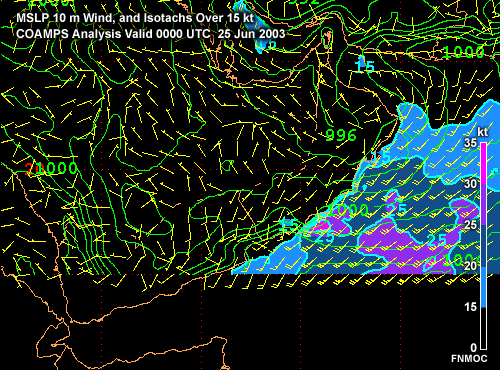
Description:
MSLP, 10m wind barbs, and isotachs (greater than 15 kt) over the Western Arabian Sea. COAMPS forecast 0000 UTC 25 Jun 2003 to 00 UTC 26 Jun 2003
File Name:
oman_coa_mslp_wind_1.gif
Credits:
FNMOC
Copyright Terms:
COMET Standard Terms
of Use
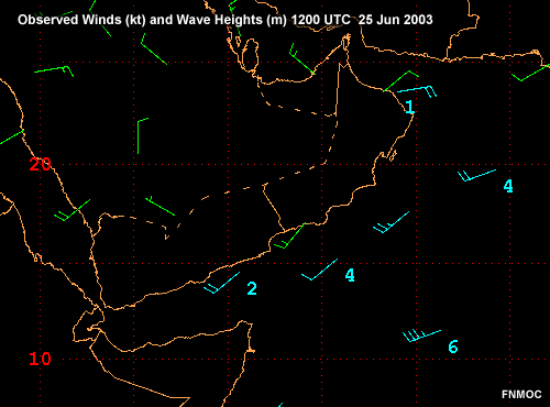
Description:
Observed winds (kt) and wave heights (m) over the Western Arabian Sea. 1200 UTC 25 Jun 2003
File Name:
oman_obs.gif
Credits:
FNMOC
Copyright Terms:
COMET Standard Terms
of Use
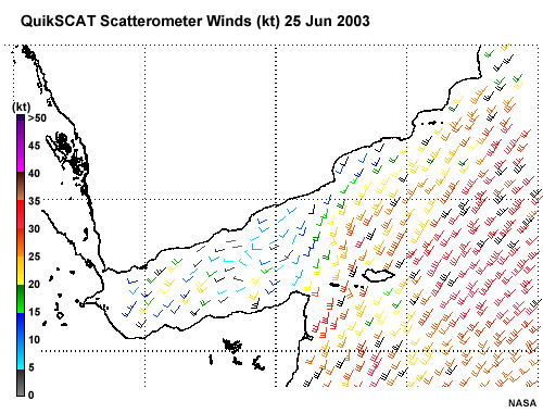
Description:
Quikscat scatterometer winds over the Western Arabian Sea, 25 Jun 2003 showing a maximum along the Oman coast
File Name:
oman_qscat.gif
Credits:
NASA
Copyright Terms:
COMET Standard Terms
of Use
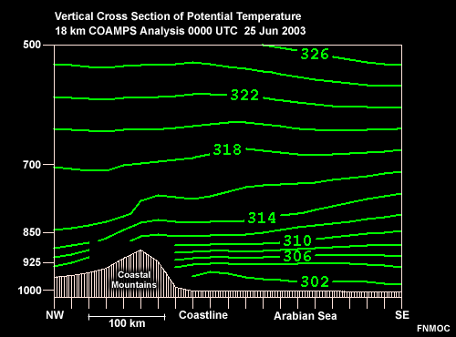
Description:
Vertical cross section of potential temperature across the Oman coast. 18-km COAMPS forecast 0000 UTC 25 Jun 2003 to 0000 UTC 26 Jun 2003
File Name:
oman_theta_01.gif
Credits:
FNMOC
Copyright Terms:
COMET Standard Terms
of Use
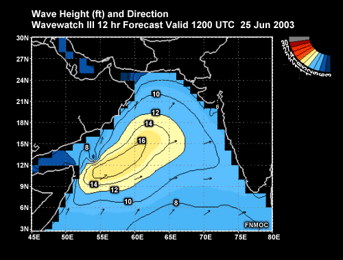
Description:
Wave height (ft) and Direction for the Arabian Sea showing high waves under the Somali Jet. Wavewatch III Analysis 1200 UTC 25-Jun-2003
File Name:
oman_wave.gif
Credits:
FNMOC
Copyright Terms:
COMET Standard Terms
of Use

Description:
10-m Wind and Isotachs over 20 kt along the Oman Coast 18-km COAMPS Analysis 1200 UTC 25 Jun 2003
File Name:
oman_wind_coamps.gif
Credits:
FNMOC
Copyright Terms:
COMET Standard Terms
of Use
Description:
10-m Wind and Isotachs over 20 kt along the Oman Coast GFS 12-hr Forecast Valid 1200 UTC 25 Jun 2003
File Name:
oman_wind_gfs.gif
Credits:
NOAA
Copyright Terms:
COMET Standard Terms
of Use
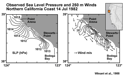
Description:
Sea Level Pressure (hPa) and Winds (m/s), CA coast, near Point Arena, showing correlation of high wind with low SLP
File Name:
ptarena_wind.gif
Credits:
Winant et al., 1988
Copyright Terms:
COMET Standard Terms
of Use
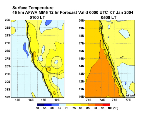
Description:
Plots of Surface Temperature along 2 different coastlines: southwest Africa and India 45-km AFWA MM5 forecasts valid 0000 UTC 21-Feb-2004 to 0000 UTC 22-Feb-2004
File Name:
surf_temp_01.jpg
Credits:
AFWA
Copyright Terms:
COMET Standard Terms
of Use
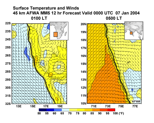
Description:
Plots of Surface Temperature and Wind along 2 different coastlines: southwest Africa and India 45-km AFWA MM5 forecasts valid 0000 UTC 21-Feb-2004 to 0000 UTC 22-Feb-2004
File Name:
surf_temp_wind_1.jpg
Credits:
AFWA
Copyright Terms:
COMET Standard Terms
of Use
Description:
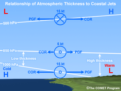
Schematic diagram of relationship between atmospheric thickness and wind, with respect to the coastal jet.
File Name:
thickness_wind.gif
Credits:
©The COMET Program
Copyright Terms:
COMET Standard Terms
of Use