Introduction

Jetstreams are intense, narrow quasi-horizontal currents of wind associated with strong vertical shear and found at or near the tropopause. A jetstream is defined by the following attributes:
- intense: at least 30 m/s for upper troposphere, at least 15 m/s for lower troposphere
- narrow: one-half to one of magnitude less in width than in length
- strong vertical wind shear: at least 5 - 10 m/s per km, one-half to one order of magnitude greater than the synoptic scale shear
A jet streak is a wind speed maximum embedded within a jet stream, like the one seen below.

Jetstreams, as well as jet streaks, are important in synoptic and mesoscale meteorology because of their implications for upper-level divergence, and thus cyclone and precipitation development.
Upper-level divergence is proportional to both the wavelength of troughs and ridges (aka the degree of curvature) as well as to wind shear.
Divergence is maximized for an upper-level wave with the following characteristics:
- large amplitude
- short wavelength
- strong wind speed and wind shear (which are a function of the horizontal thermal gradient at lower levels - the greater this baroclinicity, the greater the upper level divergence)
To understand upper-level divergence we can analyze processes in terms of the expanded ageostrophic wind equation:

Term A is the isallobaric wind, Term B is the inertial-advective wind, and Term C is the inertial-convective wind. Here we will focus mainly on the inertial-advective wind in Term B, but for a full explanation of all terms you can view the entire module on jet streak circulations at https://www.meted.ucar.edu/training_module.php?id=166#.VgWULctVhBc
The inertial-convective wind in term B has the following characteristics:
- strongest where there are changes in wind speed or direction downstream
- “points” upstream in cyclonically curved flow and downstream in anticyclonically curved flow
- “points” to the left of the flow (in NH, as are all examples herein) if speed increases downstream, and to the right if speeds decrease downstream.
Thus, on an upper-level plan view the ageostrophic vectors would look something like this for a general trough/ridge system:

We can immediately see that the ageostrophic wind has the greatest magnitude in the base of the trough, where the jet is strong and curvature is strongest.
We can also notice that the vectors point upstream within the cyclonically curved area and downstream within the anticyclonically curved areas. This creates convergence of ageostrophic motion to the west of the trough axis and divergence east of it. This is simply a reflection of supergeostrophic vs subgeostrophic flow from gradient wind theory.
The next component to consider is rapid changes in speed - jet streaks.

In this straight jet streak, we can see that the ageostrophic vectors point to the left of the flow where speeds increase downstream (in the “entrance” region of the jet streak, or where the jet streak begins in a flow-relative sense). The vectors point to the right of the flow in the exit region, where speed decreases downstream. Thus, we have divergence in the right entrance and left exit regions of the jet streak, and convergence in the left entrance and right exit regions.
Some good further discussion of the inertial-advective wind can be found in chapter 2 of Lackmann's Midlatitude Synoptic Meteorology or chapter 6 of Martin's Mid-latitude Atmospheric Dynamics.
The upper level divergence and convergence due to curvature and jet streaks mentioned here aid with ascent and descent, respectively.

Above is a conceptual model of the thermally direct and indirect circulations induced by the upper-level convergence and divergence in the streak region. In the entrance region, divergence on the right side induces ascent of warm air south of the jet, and this air moves northward where convergence forces it to descend below the left entrance region (see cross section A to A'). In the exit region, a circulation develops in the opposite sense, both in direction and in terms of thermal structure - the cool air from the north side of the jet is ascending.
This is the most basic conceptual model to illustrate jet streak circulations. In reality, jet streaks rarely occur in a uniform, zonal manner as above, and the vertical portions of the transverse circulations are much more gently sloping.
Here's a more realistic view of jet streak circulations, in which flow is induced along sloped isentropic surfaces (ignoring diabatic heating) toward the divergent regions.

Here we can see that each side of the jet streak can induce strong southerly flow at low levels. Additionally, a northerly low-level jet of sorts can be induced in the left entrance region. This can make the entrance region a favored area of heavy snow development in winter months.
Overall, the strength of these circulations will depend upon the shape and position of the jet streak within the overall curvature of the jetstream - in many cases, the effects of curvature dominate the streak circulations, as is the case with the rarely observed “jet streak in the base of the trough”. We'll now analyze some examples.
Pre-Lab Activities: Identifying and Interpreting Ageostrophic Circulation
Question 1 of 4
Given the theory for ageostrophic wind patterns associated with upper-level flow curvature, sketch in some white arrows to show the direction of ageostrophic flow within the jetstream on the 300 mb map of isotachs and heights below. Then, outline any areas of convergence in red and divergence in blue. Compare your map to the solution provided by clicking “done”.


| Tool: | Tool Size: | Color: |
|---|---|---|
Much like the conceptual model of ageostrophic flow due to curvature earlier, we can see convergence of the wind barbs (yellow) on the west side of the trough and divergence on the east side. The ageostrophic wind flows upstream within the cyclonic curvature and downstream within the anticyclonic curvature - if we look carefully at the height contours, the blue area of divergence is centered upon the inflection point where the flow shifts from cyclonic to anticyclonic; the same can be said about the red area of convergence, though the inflection is not as noticeable.
Question 2 of 4
Where are the fastest ageostrophic winds located in the previous map?
The correct answer is c.
Ageostrophic barbs of 100 knots exist in the base of the trough - much higher than on either side of the trough axis. The base is where curvature is strongest and wind speeds are strong.
This example fits the conceptual model of ageostrophic flow and curvature fairly well, and also highlighted the relative magnitude of ageostrophic flow due to curvature versus ageostrophic flow due to jet streaks - you'll notice the wind barbs along the streak on the western side of the trough did not indicate much in the way of transverse circulation around the streak.
Let's take a look at a few examples of noticeable transverse circulations around jet streaks.
Here we can see a much more zonal jet streak where the ageostrophic vectors flow to the north across the entrance region and to the south/southeast across the exit region, similar to the jet streak conceptual model.

This effect is evident regularly in straight jetstreaks in plan view, but can be partially obscured when the streak is nestled within a moderately or strongly curved trough or ridge. Cross-sections can help us capture the transverse circulation placement and magnitude.
Typically, cross sections of isotachs and ageostrophic flow will resemble something like the conceptual entrance and exit regions below.


Question 3 of 4
Examine the cross section of isotachs, potential temperature and ageostrophic circulation vectors below. Which location within a jet streak does it represent?

The correct answer is a.
Based on the conceptual model and inertial-advective wind theory above, we know this cross section was taken from the entrance region, since warm air on the right (south) is rising into a thermally direct circulation and then subsiding on the left (north) side.
Ageostrophic vectors across a moderately strong to strong exit region will look similar, except the direction of circulation is reversed and it is thermally indirect.
The plan view image below shows the location at which an exit-region cross section was created. Use it to help you answer the question below.
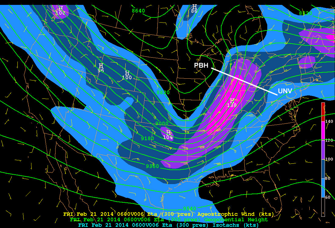
Question 4 of 4
This is the exit region cross section of isotachs from the location above. Use the white pen to draw in a couple handfuls of arrows that illustrate what the ageostrophic circulation would look like. Click done to see the solution image and discussion.


| Tool: | Tool Size: | Color: |
|---|---|---|
Here we can see shallow southeasterly ageostrophic flow near the surface ascending into a thermally direct circulation within the exit region of this broad and deep jet streak. This fits the conceptual model, though because of this jet's broadness and depth, the circulation is not as organized as the entrance region example we saw earlier.
Additionally, If we go back and take a look at the plan view ageostrophic wind barbs, we can see that there is some degree of ageostrophic flow not just upstream in the cyclonically curved area as we'd expect, but also a component to the left of the wind in the entrance region and to the right of the wind in the exit region - a combination of curvature and the streak activity.
Next Steps: Lab Activity
Now that we've done a few examples, we can proceed to the laboratory activity in which we'll investigate a few cases containing cross sections through jet streaks. In this manner we'll be able to see common themes and variations that depend on curvature and streak strength.
There are 3 cases below, along with a question set to answer for each. The imagery is zipped and will download upon clicking the link.
Each case imagery folder contains four cross-sections through a jet streak and one plan view map showing cross-section locations (labeled with the station identifiers endpoints). All cross-sections contain these identifiers in the filename. All imagery is from NOAA.
Consult your instructor to determine which cases you will be examining.
Questions for Each Case
- Looking at the plan view of heights, isotachs and ageostrophic vectors at 300 mb, where is convergence of ageostrophic vectors located? Divergence? You can use states or other geographic features/landmarks to describe the position.
- Are the cross sections from the entrance region of the jet streak consistent with the conceptual model of ageostrophic flow in that area? Briefly describe the circulation you see in terms of strength and direction.
- How does the ageostrophic circulation change from the first cross-section to the second within the entrance region? Explain in terms of direction and/or magnitude of ageostrophic flow.
- Are the cross sections from the exit region of the jet streak consistent with the conceptual model of ageostrophic flow in that area? Briefly describe the circulation you see in terms of strength and direction.
- How does the ageostrophic circulation change from the first cross-section to the second within the exit region? Explain in terms of direction and/or magnitude of ageostrophic flow.
References
Lackmann, Gary. 2011: Midlatitude Synoptic Meteorology. Boston: American Meteorological Society.
Martin, Jonathan E. 2006: Mid-Latitude Atmospheric Dynamics, A First Course. West Sussex: Wiley.