Los elementos multimedia empleados en este módulo están protegidos por diversas licencias de propiedad intelectual (copyright). Para obtener más nformación al respecto, utilice el enlaceTérminos de derechos de autor asociado a cada elemento a continuación.
Haga clic en una imagen para verla a tamaño real en una ventana o pestaña aparte de su navegador.

Descripción:
Sciamachy NO2 Data for 06-May-2005
Nombre de archivo:
69b_SCIAMACHY_Profile_Data_NO2.jpg
Créditos:
Institute of Environmental Physics, University of Bremen/NCU
Términos de derechos de autor:
Términos de uso estándar de COMET
|
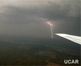
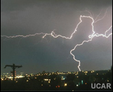
Descripción:
Lightning during a DC3 airborne mission
Nombre de archivo:
9_apps_aviation.jpg
Créditos:
UCAR
Términos de derechos de autor:
Términos de uso estándar de COMET
|
Descripción:
Interface graphic for accessing information about how the GLM will benefit atmospheric chemistry
Nombre de archivo:
9_apps_chem.jpg
Créditos:
Wikimedia Commons Ben Mils and Jynto
Términos de derechos de autor:
Términos de uso estándar de COMET
|
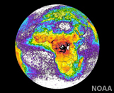
Descripción:
Interface graphic for accessing information about how the GLM will benefit climate studies
Nombre de archivo:
9_apps_climate.jpg
Créditos:
NOAA
Términos de derechos de autor:
Términos de uso estándar de COMET
|
Descripción:
Interface graphic for accessing information about how the GLM will benefit early warnings of thunderstorms.
Nombre de archivo:
9_apps_convection.jpg
Créditos:
UCAR
Términos de derechos de autor:
Términos de uso estándar de COMET
|
Descripción:
Interface graphic for accessing information about how the GLM will benefit early warnings of ground strike hazards
Nombre de archivo:
9_apps_earlyStrike.jpg
Créditos:
UCAR
Términos de derechos de autor:
Términos de uso estándar de COMET
|
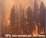
Descripción:
Interface graphic for accessing information about how the GLM will benefit fire detection and monitoring
Nombre de archivo:
9_apps_fires.jpg
Créditos:
NPS Photo by Jeff Henry
Términos de derechos de autor:
Términos de uso estándar de COMET
|
Descripción:
Interface graphic for accessing information about how the GLM will benefit NWP
Nombre de archivo:
9_apps_nwp.jpg
Créditos:
NOAA
Términos de derechos de autor:
Términos de uso estándar de COMET
|
Descripción:
Interface graphic for accessing information about how the GLM will benefit QPE
Nombre de archivo:
9_apps_qpe.jpg
Créditos:
NOAA
Términos de derechos de autor:
Términos de uso estándar de COMET
|

Descripción:
Interface graphic for accessing information about how the GLM will benefit tropical cyclone monitoring
Nombre de archivo:
9_apps_tc.jpg
Créditos:
NOAA
Términos de derechos de autor:
Términos de uso estándar de COMET
|
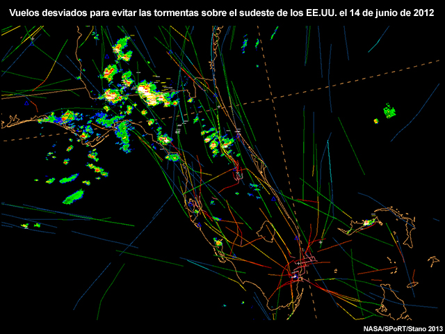
Descripción:
A plot of aircraft tracks over the Southeast U.S. showing the use of lightning detection data in aviation routing for June 14, 2012.
Nombre de archivo:
air_traffic_routing_between_storms.jpg
Créditos:
NOAA/NASA/SPoRT/Stano 2013
Términos de derechos de autor:
Términos de uso estándar de COMET
|
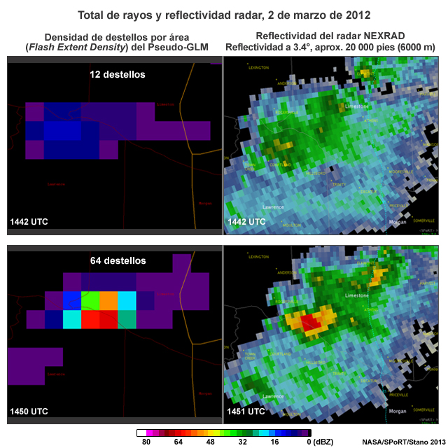
Descripción:
Total lightning (3.4 degree reflectivity, approx. 20 kft) from the Pseudo-GLM flash extent density vs. NEXRAD radar reflectivity, 02 March 2012
Nombre de archivo:
AL_EF2_tornado_02mar12_FED_4panel.jpg
Créditos:
NASA/SPoRT/Stano 2013
Términos de derechos de autor:
Términos de uso estándar de COMET
|
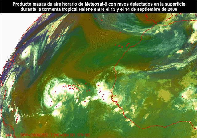
Ver/guardar archivo .mp4
Descripción:
Hourly animation of the Meteosat-9 SEVIRI airmass RGB product and surface based lightning during tropical storm Helene from 13 to 14 September, 2006.
Nombre de archivo:
atl_hurr_lightning_ani.mp4
Créditos:
CIRA/NOAA/© EUMETSAT 2006
Términos de derechos de autor:
Términos de uso estándar de COMET
|
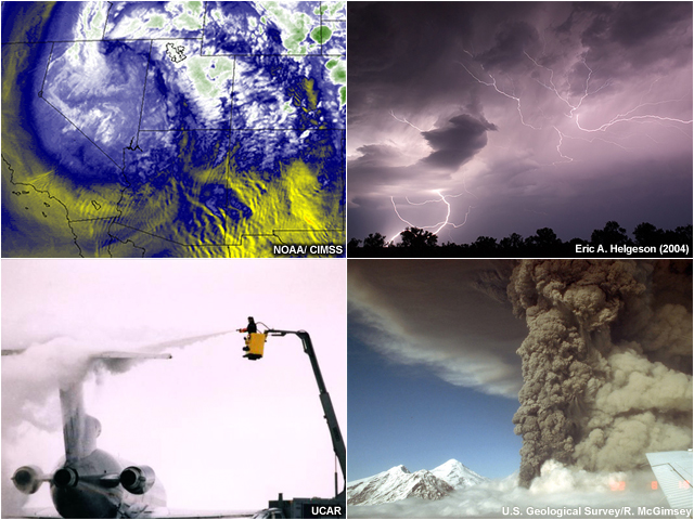
Descripción:
Four panel graphic showing examples of aviation hazards including lightning, turbulence, icing, and volcanic ash.
Nombre de archivo:
aviation_hazards_4panel.jpg
Créditos:
see instructions above
Términos de derechos de autor:
Términos de uso estándar de COMET
|

Descripción:
Example of a lightning jump for a supercell thunderstorm in south-central Tennessee as observed by Univ. of Huntsville Alabama's ARMOR radar on April 10, 2009.
Nombre de archivo:
carey_ltg_jump_10apr09.jpg
Créditos:
Schultz et al. 2015
Términos de derechos de autor:
Términos de uso estándar de COMET
|
|
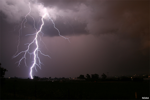
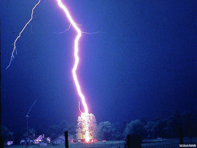
Descripción:
Photo of cloud-to-ground lightning
Nombre de archivo:
cloud_to_ground_lightning.jpg
Créditos:
NOAA
Términos de derechos de autor:
Términos de uso estándar de COMET
|
Ver/guardar archivo .mp4
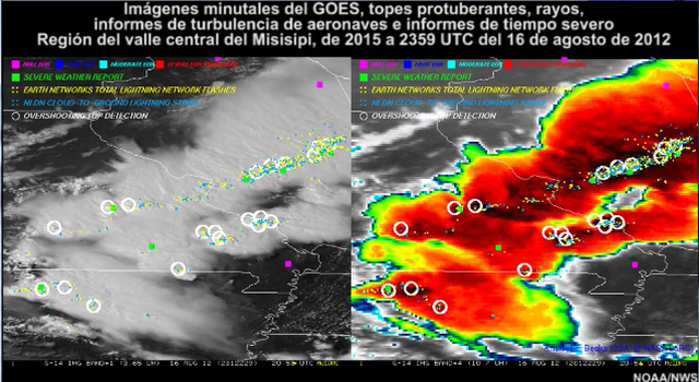
Descripción:
Combined 1-min GOES imagery, overshooting top detections, lightning, aircraft turbulence reports, and severe weather reports from 2015 to 2359 UTC on 16 Aug 2012 over the central Mississippi Valley region.
Nombre de archivo:
combined_storm_obs.mp4
Créditos:
NOAA/NWS
Términos de derechos de autor:
Términos de uso estándar de COMET
|
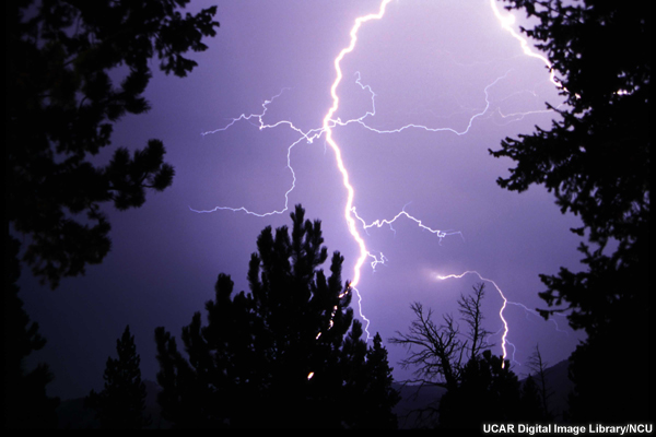
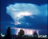
Descripción:
Photo of lightning at night amongst trees.
Nombre de archivo:
DI00325.jpg
Créditos:
UCAR Digital Image Library/NCU
Términos de derechos de autor:
Términos de uso estándar de COMET
|
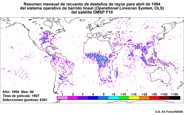
Descripción:
DMSP F10 OLS global monthly lightning total flash count summary for April 1994.
Nombre de archivo:
dmsp_ols_lightning_summary_1994.jpg
Créditos:
U.S. Air Force/NASA
Términos de derechos de autor:
Términos de uso estándar de COMET
|
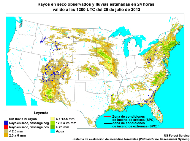
Descripción:
Map of the CONUS showing observed dry lightning and estimated rainfall valid at 12 UTC on July 29, 2012.
Nombre de archivo:
dry_ltng_us_20jul2012.jpg
Créditos:
U.S. Forest Service, Wildland Fire Assessment System
Términos de derechos de autor:
Términos de uso estándar de COMET
|
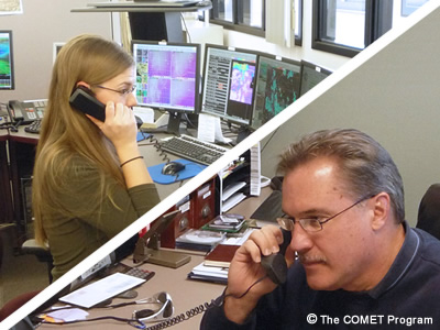
Descripción:
Split screen with photos of an emergency manager talking on the telephone to a forecaster
Nombre de archivo:
em_communication.jpg
Créditos:
©The COMET Program
Términos de derechos de autor:
Términos de uso estándar de COMET
|
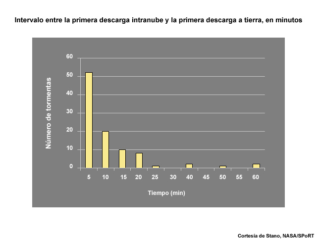
Descripción:
Plot showing the delay in minutes from the first intra-cloud lightning flash to first cloud-to-ground strike.
Nombre de archivo:
first_ic_to_first_cg_flash_time_delay.jpg
Créditos:
Courtesy of Stano, NASA/SPoRT
Términos de derechos de autor:
Términos de uso estándar de COMET
|
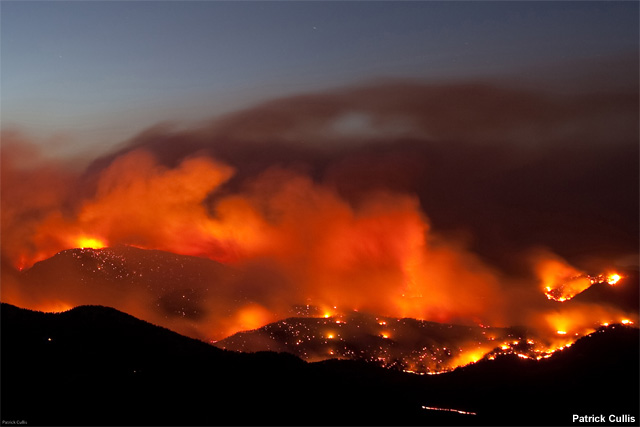
Descripción:
Photograph of the Fourmile fire in Boulder, Colorado foothills, 6 Sep 2010
Nombre de archivo:
fourmile_fire.jpg
Créditos:
Patrick Cullis
Términos de derechos de autor:
Términos de uso estándar de COMET
|
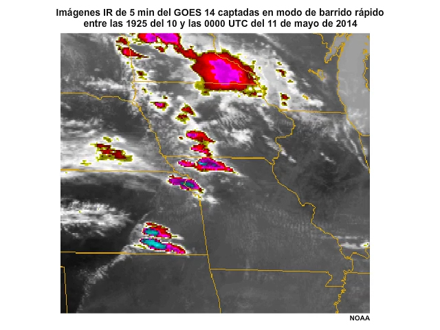
Ver/guardar archivo .mp4
Descripción:
Animation of 5-minute GOES-14 infrared rapid scan imagery showing rapid development of deep convection across the Midwest on the afternoon of 10 May, 2014.
Nombre de archivo:
g14_ir4_5min_10may2014_ani.mp4
Créditos:
NOAA
Términos de derechos de autor:
Términos de uso estándar de COMET
|
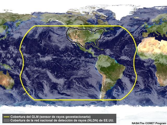
Descripción:
Geostationary Lightning Mapper coverage overlaid on the full-Earth globe.
Nombre de archivo:
glm_coverage.jpg
Créditos:
NASA / Goodman et al. 2013 / The COMET Program
Términos de derechos de autor:
Términos de uso estándar de COMET
|

Descripción:
Geostationary Lightning Mapper overage from a GOES-East satellite position at 75 degrees west longitude
Nombre de archivo:
glm_coverage_goes_east.jpg
Créditos:
NASA / Goodman et al. 2013 / The COMET Program
Términos de derechos de autor:
Términos de uso estándar de COMET
|

Descripción:
Geostationary Lightning Mapper overage from a GOES-West position at 137 degrees west longitude
Nombre de archivo:
glm_coverage_goes_west.jpg
Créditos:
NASA / Goodman et al. 2013 / The COMET Program
Términos de derechos de autor:
Términos de uso estándar de COMET
|

Descripción:
Geostationary Lightning Mapper combined coverage from GOES-West and GOES-East satellite locations
Nombre de archivo:
glm_coverage_goes_west_east_combined.jpg
Créditos:
NASA / Goodman et al. 2013 / The COMET Program
Términos de derechos de autor:
Términos de uso estándar de COMET
|
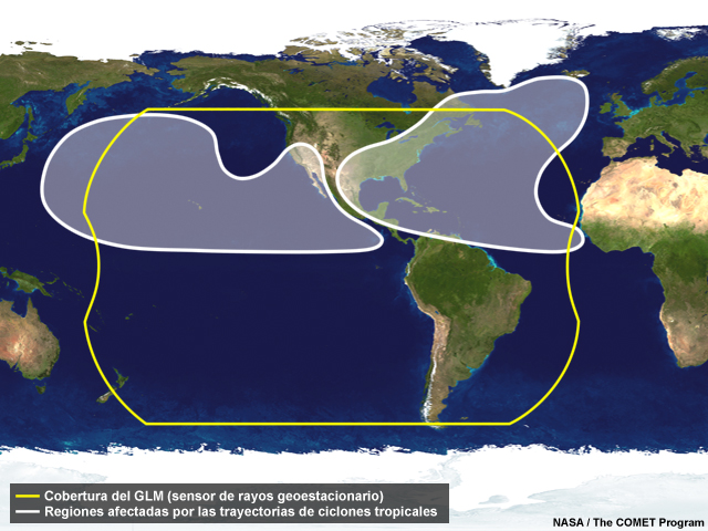
Descripción:
GOES view of Geostationary Lightning Mapper (GLM) coverage and hurricane impact areas.
Nombre de archivo:
GLM_coverage_hurricane_impact.jpg
Créditos:
NASA/NOAA/The COMET Program
Términos de derechos de autor:
Términos de uso estándar de COMET
|

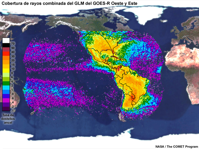
Descripción:
Geostationary Lightning Mapper (GLM) coverage map overlaid on Western Hemisphere. Within GLM coverage, the annual lightning climatology is shown.
Nombre de archivo:
GLM_Coverage_Lightning_Climo_v2.jpg
Créditos:
NASA/Goodman et al. 2013
Términos de derechos de autor:
Términos de uso estándar de COMET
|
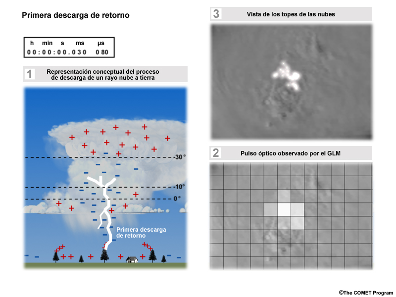
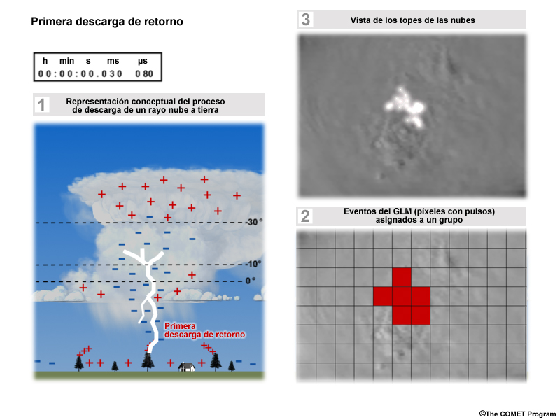
Descripción:
3-panel representation of a cloud-to-ground lightning strike, optical pulses from above the cloud top generated by that strike, and a simulated GLM detection of the cloud top optical pulses at 8-km resolution.
Nombre de archivo:
glm_grid1.jpg
Créditos:
©The COMET Program
Términos de derechos de autor:
Términos de uso estándar de COMET
|
Descripción:
3-panel representation of a cloud-to-ground lightning strike, optical pulses from above the cloud top generated by that strike, and a simulated GLM detection of the cloud top optical pulses at 8-km resolution.
Nombre de archivo:
glm_grid2.jpg
Créditos:
©The COMET Program
Términos de derechos de autor:
Términos de uso estándar de COMET
|
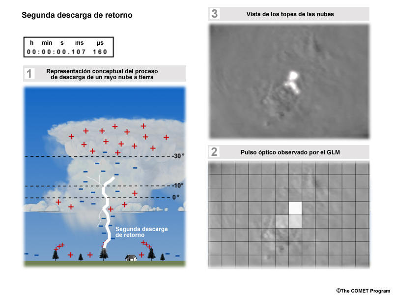
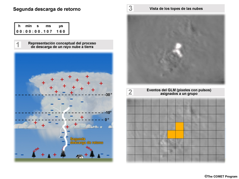
Descripción:
3-panel representation of a cloud-to-ground lightning strike, optical pulses from above the cloud top generated by that strike, and a simulated GLM detection of the cloud top optical pulses at 8-km resolution showing pulses aggregated into one group.
Nombre de archivo:
glm_grid3.jpg
Créditos:
©The COMET Program
Términos de derechos de autor:
Términos de uso estándar de COMET
|
Descripción:
3-panel representation of a cloud-to-ground lightning strike, optical pulses from above the cloud top generated by that strike, and a simulated GLM detection of the cloud top optical pulses at 8-km resolution showing pulses aggregated into one group.
Nombre de archivo:
glm_grid4.jpg
Créditos:
©The COMET Program
Términos de derechos de autor:
Términos de uso estándar de COMET
|
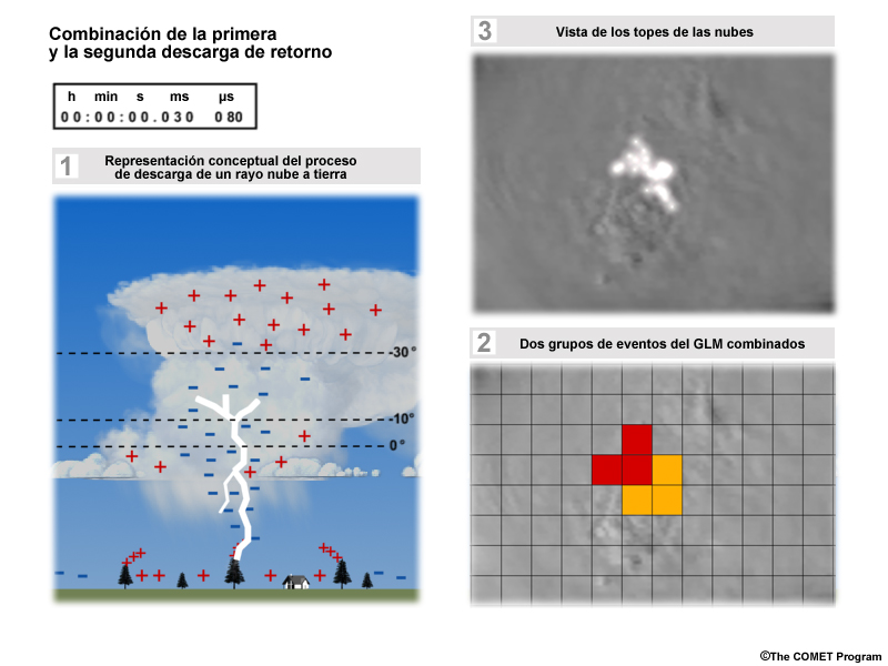
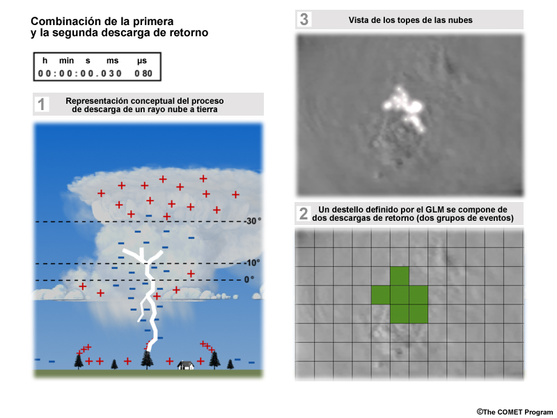
Descripción:
3-panel representation of a cloud-to-ground lightning strike, optical pulses from above the cloud top generated by that strike, and a simulated GLM detection of the cloud top optical pulses at 8-km resolution showing two pulse (event) groups from two return strokes (during one lightning strike) assigned to one group.
Nombre de archivo:
glm_grid5.jpg
Créditos:
©The COMET Program
Términos de derechos de autor:
Términos de uso estándar de COMET
|
Descripción:
3-panel representation of a cloud-to-ground lightning strike, optical pulses from above the cloud top generated by that strike, and a simulated GLM detection of the cloud top optical pulses at 8-km resolution showing two pulse (event) groups from two return strokes (during one lightning strike) assigned to one group.
Nombre de archivo:
glm_grid6.jpg
Créditos:
©The COMET Program
Términos de derechos de autor:
Términos de uso estándar de COMET
|
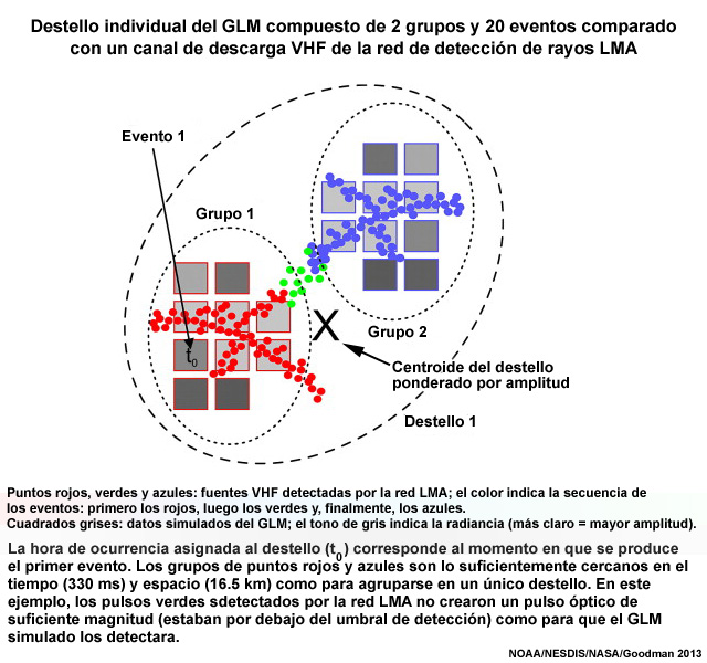
Descripción:
Illustration of a single GLM flash composed of 2 groups and 20 events relative to a LMA VHF lightning channel
Nombre de archivo:
GLM_single_flash_depiction_Goodman_2013.jpg
Créditos:
NOAA/NESDIS/NASA/Goodman et al. 2013
Términos de derechos de autor:
Términos de uso estándar de COMET
|
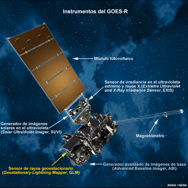
Descripción:
Picture of GOES-R and its instruments in space
Nombre de archivo:
goes_r_instruments.jpg
Créditos:
NOAA/NASA
Términos de derechos de autor:
Términos de uso estándar de COMET
|
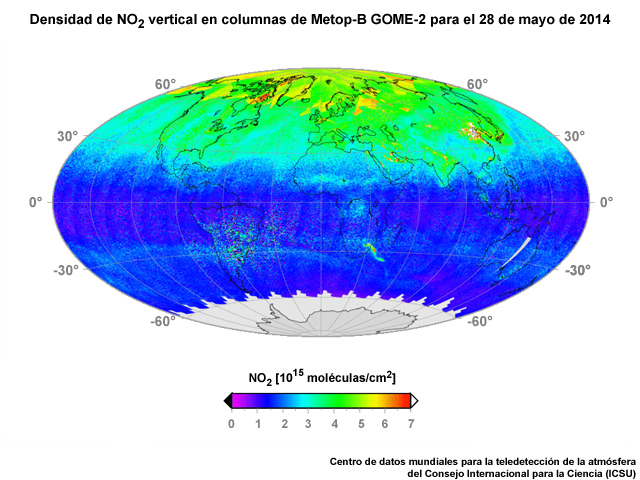
Descripción:
Total amount of nitrogen dioxide (NO2) in the global troposphere for one month of data from the GOME-2 instrument on Metop-B polar-orbiting satellite for April 2014.
Nombre de archivo:
gome2_no2trop_29may2014.jpg
Créditos:
The ICSU World Data Center for Remote Sensing of the Atmosphere
Términos de derechos de autor:
Términos de uso estándar de COMET
|

Descripción:
NWS AWIPS multi-panel display showing various lightning data sources including LMA, ENTLN and NLDN during August 2015.
Nombre de archivo:
ground_ltg_networks_aug2015.jpg
Créditos:
NOAA/NWS
Términos de derechos de autor:
Términos de uso estándar de COMET
|
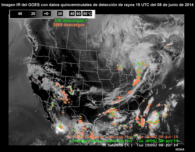
Descripción:
AWIPS II display of a GOES IR image with overlay of 15-min lightning data for 19 UTC on July 8, 2014.
Nombre de archivo:
ir_15min_ltg_19utc_08jul2014.jpg
Créditos:
NOAA
Términos de derechos de autor:
Términos de uso estándar de COMET
|
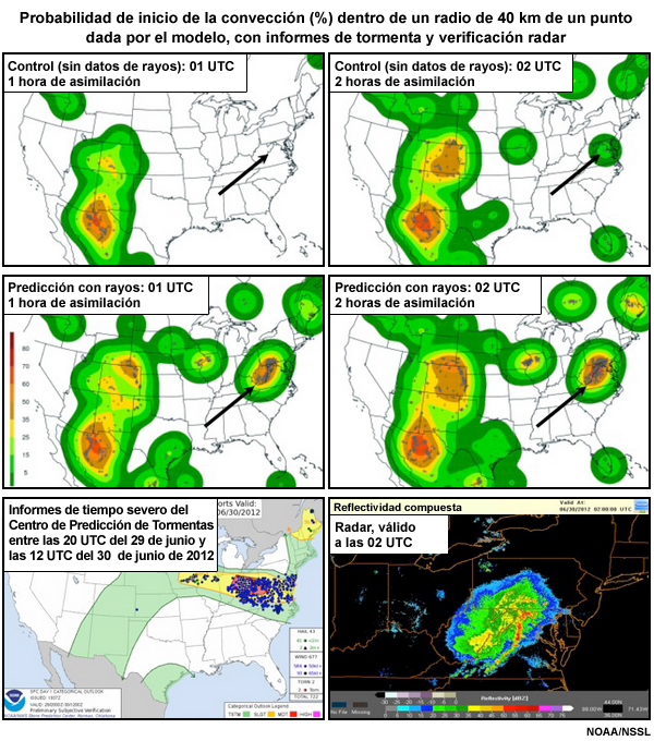
Descripción:
Plots showing model convective initiation probability (%) with 25 mi of a point with storm reports and radar verification.
Nombre de archivo:
lgtng_assim_exp_GLMmod.jpg
Créditos:
NOAA/NSSL
Términos de derechos de autor:
Términos de uso estándar de COMET
|
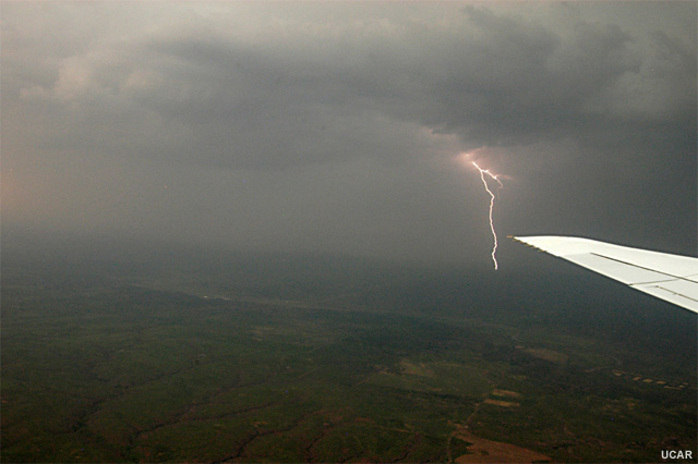
Descripción:
Lightning during a DC3 airborne mission
Nombre de archivo:
lightning_airplane.jpg
Créditos:
UCAR
Términos de derechos de autor:
Términos de uso estándar de COMET
|
|
|
|
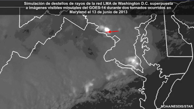
Ver/guardar archivo .mp4
Descripción:
Animation showing simulated GLM lightning flashes from ground-based Washington, D.C. LMA (Lightning Mapping Array) data over GOES-14 1-minute imagery during two tornadoes in Maryland on 13 June 2013.
Nombre de archivo:
LightningTornado_short_ani_13jun2013.mp4
Créditos:
NOAA/NESDIS/STAR
Términos de derechos de autor:
Términos de uso estándar de COMET
|
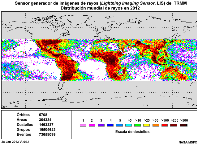
Descripción:
World map showing the distribution of cloud-top lightning detections by the TRMM Lightning Imaging Sensor (LIS) in 2012.
Nombre de archivo:
lis_mission_world_2012.jpg
Créditos:
NASA/MSFC
Términos de derechos de autor:
Términos de uso estándar de COMET
|

Descripción:
Annual average number of lightning flashes per square km from merged LIS and OTD gridded datasets from April 1995 to February 2003.
Nombre de archivo:
LIS_OTD_HRFC_AnnualFlashRate.jpg
Créditos:
NASA TRMM Team
Términos de derechos de autor:
Términos de uso estándar de COMET
|

Descripción:
Florida thunderstorms viewed by the NASA TRMM satellite instruments: the Lightning Imaging Sensor (LIS, left) and the TRMM Microwave Imager (TMI, right). The LIS shows dense clusters of lightning activity where the TMI shows high values of brightness temperature.
Nombre de archivo:
LIS_TMI_Thunderstorms_Lightning_20140421.jpg
Créditos:
NASA/MSFC/Driscoll
Términos de derechos de autor:
Términos de uso estándar de COMET
|
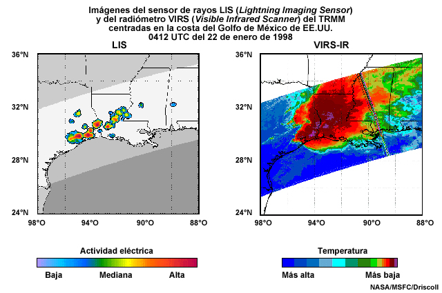
Descripción:
Comparison between the Lightning Imaging Sensor and VIRS-IR imager along the U.S. Gulf Coast region and a heavy rain event in Houston, Texas at 04:12 UTC on January 22, 1998.
Nombre de archivo:
LIS_VIRS_comparison_22jan1998.jpg
Créditos:
NASA/MSFC/Driscoll
Términos de derechos de autor:
Términos de uso estándar de COMET
|
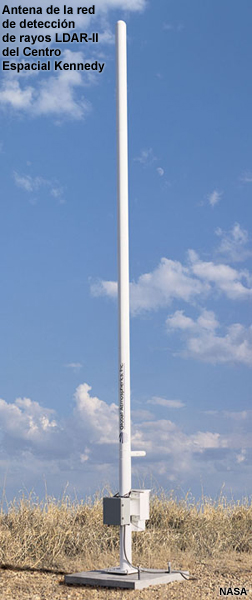
Descripción:
Photo of antenna from the Kennedy Space Center's LDAR-II lightning detection network.
Nombre de archivo:
lma_crop.jpg
Créditos:
NASA
Términos de derechos de autor:
Términos de uso estándar de COMET
|

Descripción:
A three-panel graphic showing the evolution of an average thunderstorm cloud-to-ground lightning strike with one panel showing a conceptual model, a second panel showing lightning as observed by both UHF and VHF radio detection systems, and a third panel showing optical pulses from above the cloud top.
Nombre de archivo:
ltg_ani.jpg
Créditos:
©The COMET Program
Términos de derechos de autor:
Términos de uso estándar de COMET
|
Ver/guardar archivo .mp4
Descripción:
A three-panel animation showing the evolution of an average thunderstorm cloud-to-ground lightning strike with one panel showing a conceptual model, a second panel showing lightning as observed by both UHF and VHF radio detection systems, and a third panel showing optical pulses from above the cloud top.
Nombre de archivo:
ltg_ani.mp4
Créditos:
©The COMET Program
Términos de derechos de autor:
Términos de uso estándar de COMET
|
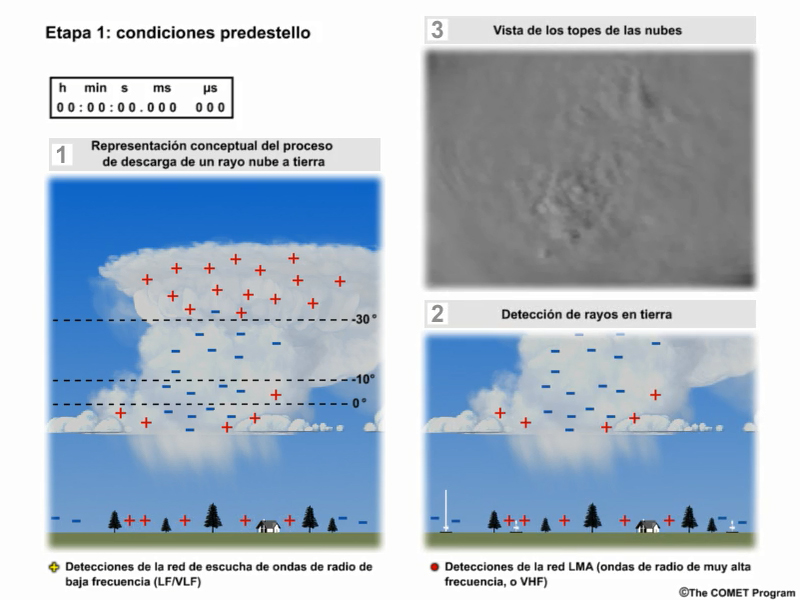
Descripción:
A three-panel display showing an average thunderstorm and ground-based detection systems.
Nombre de archivo:
ltg_ani_1.jpg
Créditos:
©The COMET Program
Términos de derechos de autor:
Términos de uso estándar de COMET
|
|
Ver/guardar archivo .mp4
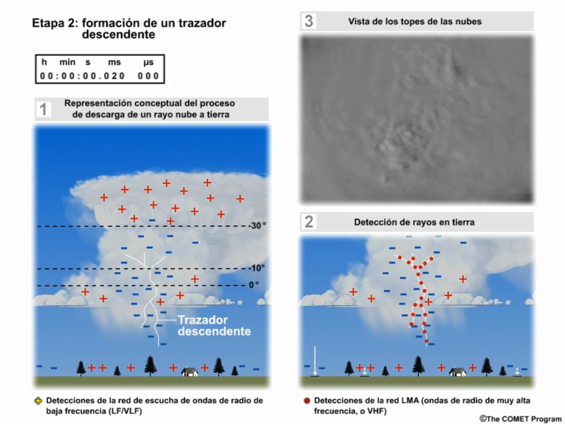
Descripción:
A three-panel animation showing the evolution of an average thunderstorm cloud-to-ground lightning strike and ground-based detection system observations during the formation of the stepped leader.
Nombre de archivo:
ltg_ani_2.mp4
Créditos:
©The COMET Program
Términos de derechos de autor:
Términos de uso estándar de COMET
|

Descripción:
A three-panel animation showing the evolution of an average thunderstorm cloud-to-ground lightning strike and ground-based detection system observations during the formation of the stepped leader.
Nombre de archivo:
ltg_ani_2.jpg
Créditos:
©The COMET Program
Términos de derechos de autor:
Términos de uso estándar de COMET
|
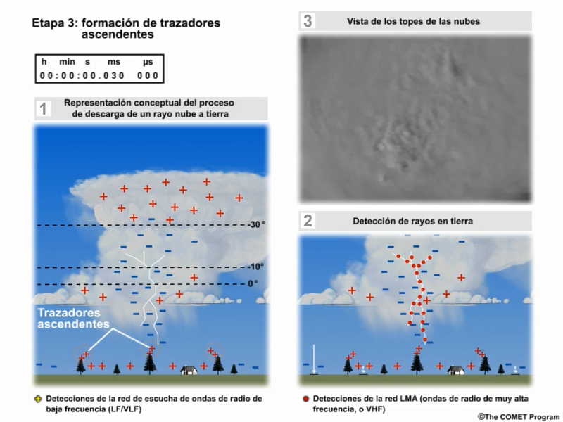
Ver/guardar archivo .mp4
Descripción:
A three-panel animation showing the evolution of an average thunderstorm cloud-to-ground lightning strike and ground-based detection system observations during the formation of the upward streamers.
Nombre de archivo:
ltg_ani_3.mp4
Créditos:
©The COMET Program
Términos de derechos de autor:
Términos de uso estándar de COMET
|

Descripción:
A three-panel animation showing the evolution of an average thunderstorm cloud-to-ground lightning strike and ground-based detection system observations during the formation of the upward streamers.
Nombre de archivo:
ltg_ani_3.jpg
Créditos:
©The COMET Program
Términos de derechos de autor:
Términos de uso estándar de COMET
|
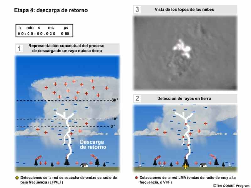
Descripción:
A three-panel animation showing the evolution of an average thunderstorm cloud-to-ground lightning strike and ground-based detection system observations during the formation of the first return stroke.
Nombre de archivo:
ltg_ani_4.jpg
Créditos:
©The COMET Program
Términos de derechos de autor:
Términos de uso estándar de COMET
|

Ver/guardar archivo .mp4
Descripción:
A three-panel animation showing the evolution of an average thunderstorm cloud-to-ground lightning strike and ground-based detection system observations during the formation of the first return stroke.
Nombre de archivo:
ltg_ani_4.mp4
Créditos:
©The COMET Program
Términos de derechos de autor:
Términos de uso estándar de COMET
|

Ver/guardar archivo .mp4
Descripción:
A three-panel animation showing the evolution of an average thunderstorm cloud-to-ground lightning strike and ground-based detection system observations during the formation of the first dart leader.
Nombre de archivo:
ltg_ani_5.mp4
Créditos:
©The COMET Program
Términos de derechos de autor:
Términos de uso estándar de COMET
|

Descripción:
A three-panel animation showing the evolution of an average thunderstorm cloud-to-ground lightning strike and ground-based detection system observations during the formation of the first dart leader.
Nombre de archivo:
ltg_ani_5.jpg
Créditos:
©The COMET Program
Términos de derechos de autor:
Términos de uso estándar de COMET
|

Ver/guardar archivo .mp4
Descripción:
A three-panel animation showing the evolution of an average thunderstorm cloud-to-ground lightning strike and ground-based detection system observations during the formation of a second return stroke.
Nombre de archivo:
ltg_ani_6.mp4
Créditos:
©The COMET Program
Términos de derechos de autor:
Términos de uso estándar de COMET
|
Descripción:
A three-panel animation showing the evolution of an average thunderstorm cloud-to-ground lightning strike and ground-based detection system observations during the formation of a second return stroke.
Nombre de archivo:
ltg_ani_6.jpg
Créditos:
©The COMET Program
Términos de derechos de autor:
Términos de uso estándar de COMET
|

Ver/guardar archivo .mp4
Descripción:
A three-panel animation showing the evolution of an average thunderstorm cloud-to-ground lightning strike and ground-based detection system observations during the formation of successive dart leaders and return stroke, four in all.
Nombre de archivo:
ltg_ani_7.mp4
Créditos:
©The COMET Program
Términos de derechos de autor:
Términos de uso estándar de COMET
|

Descripción:
A three-panel animation showing the evolution of an average thunderstorm cloud-to-ground lightning strike and ground-based detection system observations during the formation of successive dart leaders and return stroke, four in all.
Nombre de archivo:
ltg_ani_7.jpg
Créditos:
©The COMET Program
Términos de derechos de autor:
Términos de uso estándar de COMET
|
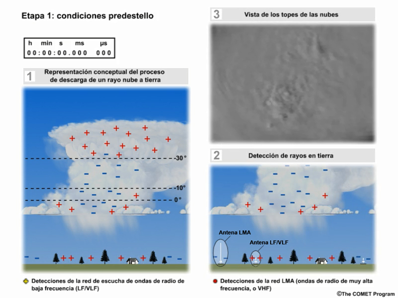
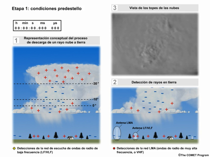
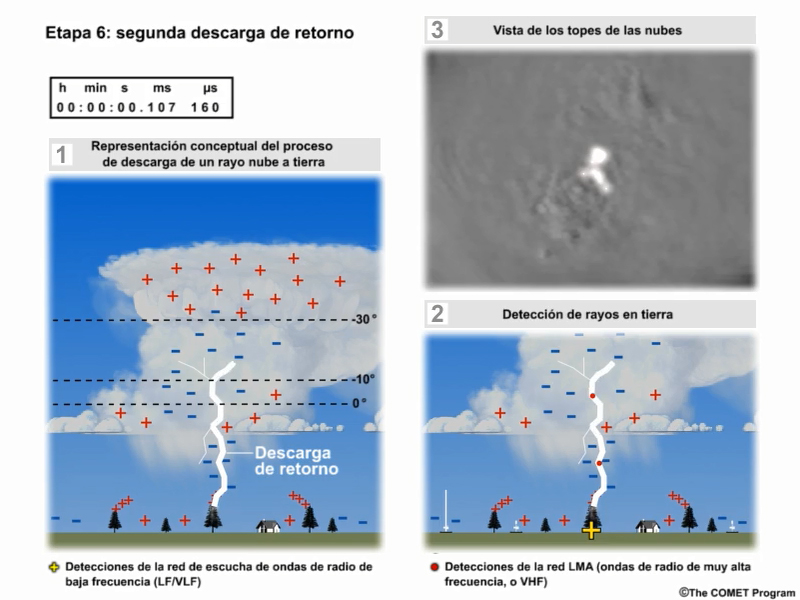
Descripción:
The first frame in a three-panel animation showing the evolution of an average thunderstorm cloud-to-ground lightning strike with one panel showing a conceptual model, a second panel showing lightning as observed by both VHF and LF/VLF radio detection systems, and a third panel showing optical pulses from above the cloud top.
Nombre de archivo:
ltg_ani_still.jpg
Créditos:
©The COMET Program / NOAA
Términos de derechos de autor:
Términos de uso estándar de COMET
|
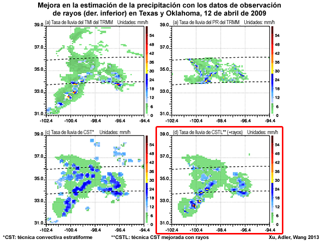
Descripción:
Instantaneous rainfall estimates (10-km resolution) improved with lightning observations for a young thunderstorm complex over Oklahoma and Texas on April 12, 2009.
Nombre de archivo:
ltg_enhanced_qpe.jpg
Créditos:
Xu, Adler, Wang 2013
Términos de derechos de autor:
Términos de uso estándar de COMET
|
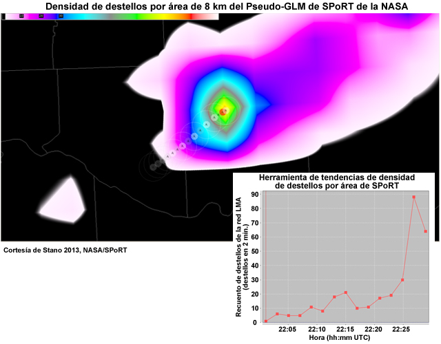
Descripción:
Two plots, one showing NASA SPoRT's Pseudo-GLM Flash Extent Density product and the other showing flash extent density trend for an intensifying thunderstorm cell.
Nombre de archivo:
ltg_ext_dens_and_trend_tool.jpg
Créditos:
Courtesy of Stano 2013, NASA/SPoRT (applies to both plots)
Términos de derechos de autor:
Términos de uso estándar de COMET
|
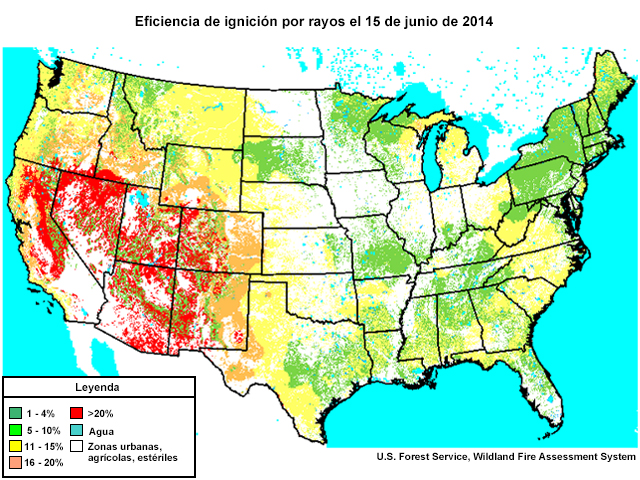
Descripción:
Map of the CONUS showing lightning ignition efficiency for 15 Jun 2014.
Nombre de archivo:
ltg_ign_efficiency_us_15jun2014.jpg
Créditos:
U.S. Forest Service, Wildland Fire Assessment System
Términos de derechos de autor:
Términos de uso estándar de COMET
|
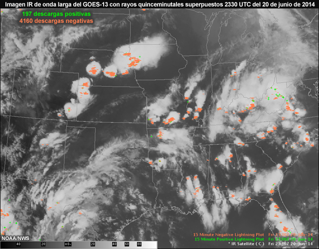
Descripción:
NWS AWIPS display of GOES-13 IR ch.4 image with 15-minute lightning data overlay showing thunderstorms across the central and eastern U.S. on June 20, 2014.
Nombre de archivo:
ltg_ir4_2330utc_20jun14.jpg
Créditos:
NOAA/NWS
Términos de derechos de autor:
Términos de uso estándar de COMET
|
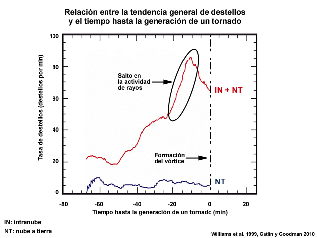
Descripción:
Plot showing the generalized flash rate trend vs. tornado time
Nombre de archivo:
ltg_jump_annotated.jpg
Créditos:
Williams et al. 1999, Gatlin & Goodman 2010
Términos de derechos de autor:
Términos de uso estándar de COMET
|
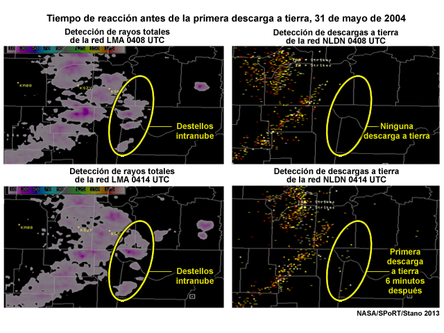
Descripción:
Comparison between LMA total lightning product and NLDN cloud-to-ground lightning flash product showing a 6 minute lead time when using the total lightning product before the first cloud-to-ground stike on May 31, 2004.
Nombre de archivo:
ltg_leadtime_may2004.jpg
Créditos:
NASA/SPoRT/Stano 2013
Términos de derechos de autor:
Términos de uso estándar de COMET
|
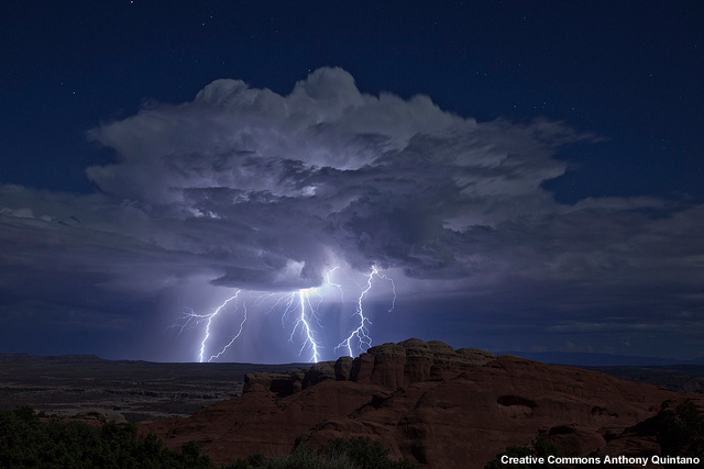
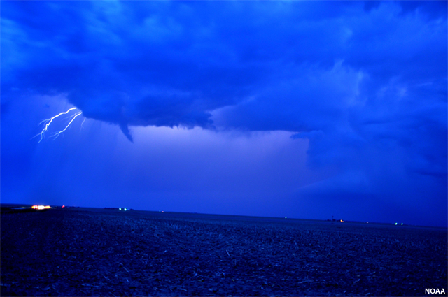
Descripción:
Photo of lightning near Moab, Utah.
Nombre de archivo:
ltg_moab_utah_sep2013.jpg
Créditos:
Creative Commons Anthony Quintano
Términos de derechos de autor:
Términos de uso estándar de COMET
|

Descripción:
Plot based on NASA research showing the average increase in tropospheric ozone gas (O3) 24 hours after lightning storms.
Nombre de archivo:
ltg_nox_ozone.jpg
Créditos:
Lesley Ott, NASA
Términos de derechos de autor:
Términos de uso estándar de COMET
|
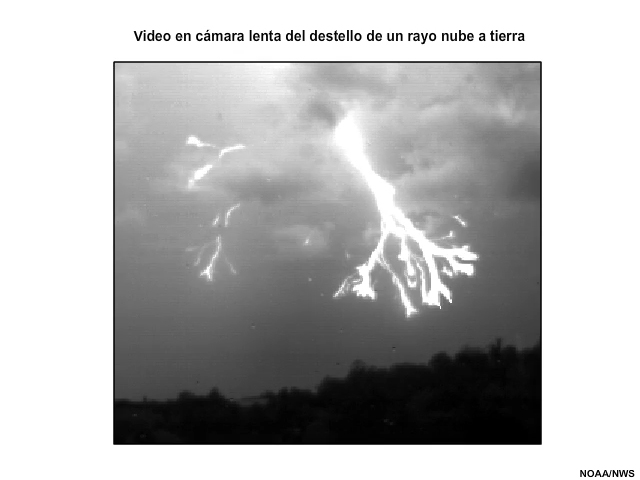
Ver/guardar archivo .mp4
Descripción:
High speed video (shown in slow motion) showing the life cycle of a cloud-to-ground lightning flash with a single return stroke filmed at 4000 frames per second.
Nombre de archivo:
ltg_stepped_leader_return_stroke.mp4
Créditos:
NOAA/NWS
Términos de derechos de autor:
Términos de uso estándar de COMET
|
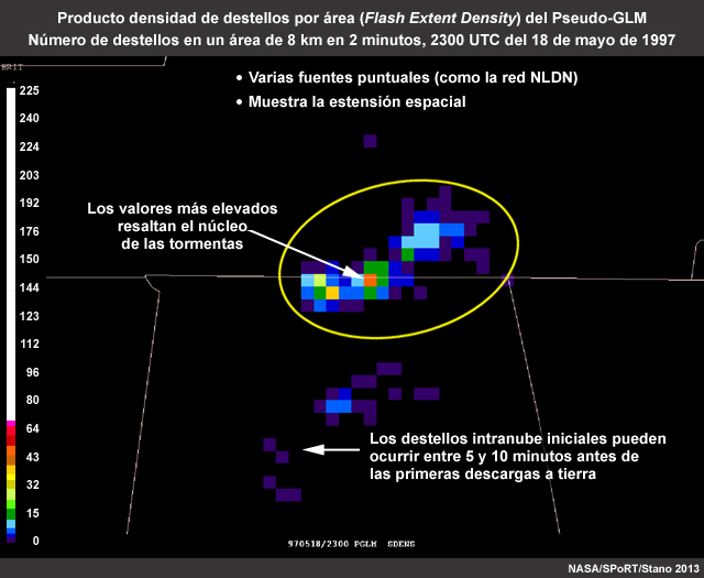
Descripción:
GLM flash extent density product showing the number of flashes for 8 km over 2 minutes on 18 May 1997
Nombre de archivo:
NALMA_flash_ext_dens_18may1997.jpg
Créditos:
NASA/SPoRT/Stano 2013
Términos de derechos de autor:
Términos de uso estándar de COMET
|
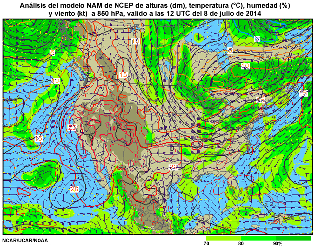
Descripción:
NCEP NAM model analysis of 850 hPa heights, temperature, humidity and winds for 12 UTC on July 08, 2014.
Nombre de archivo:
nam_850hpa_anal_12utc_08jul2014.jpg
Créditos:
NCAR/UCAR/NOAA
Términos de derechos de autor:
Términos de uso estándar de COMET
|
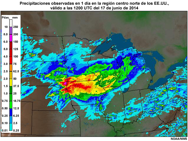
Descripción:
1-Day observed precipitation (radar, rain gauge, satellite) covering the North Central U.S., valid 12 UTC on 17 June, 2014.
Nombre de archivo:
nc_rfc_24hr_precip_17jun2014.jpg
Créditos:
NOAA/NWS
Términos de derechos de autor:
Términos de uso estándar de COMET
|
Descripción:
United States National Lightning Detection Network coverage on the globe with satellite image of thunderstorms and other clouds.
Nombre de archivo:
NLDN_Coverage_Thunderstorms.jpg
Créditos:
NASA / The COMET Program
Términos de derechos de autor:
Términos de uso estándar de COMET
|
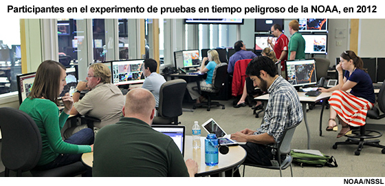
Descripción:
Photo of participants taken 10 May 2012 during NOAA's HWT (Hazardous Weather Testbed) 2012 Spring Experiment.
Nombre de archivo:
NOAA_NWS_10may2012.jpg
Créditos:
NOAA/NSSL
Términos de derechos de autor:
Términos de uso estándar de COMET
|
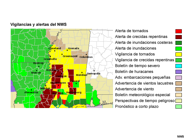
Descripción:
Watches and warnings covering the Jackson, Mississippi National Weather Service warning area during the landfall of Hurricane Gustav along the Louisiana coast on Septempber 1, 2008.
Nombre de archivo:
NWS_WFO_Watches_Warnings_Gustav.jpg
Créditos:
NOAA/NWS
Términos de derechos de autor:
Términos de uso estándar de COMET
|
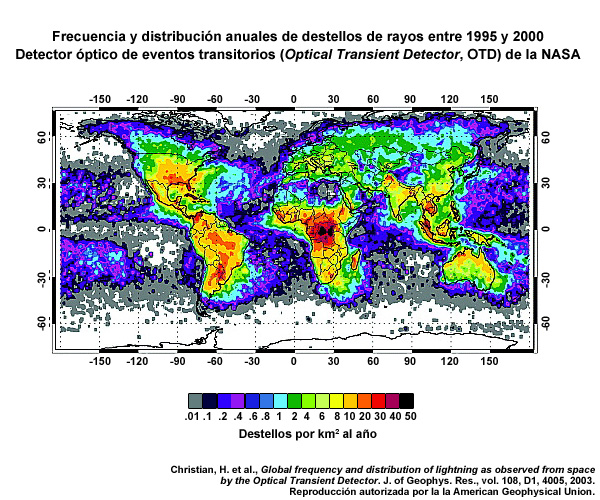
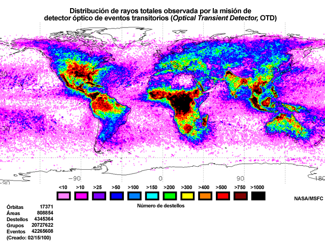
Descripción:
The annualized distribution of total lightning activity as seen by NASA's OTD (Optical Transient Detector) on board the Orbview-1 (formerly MicroLab-1) polar-orbiting microsatellite from 4 May 1995 to 21 March 2000.
Nombre de archivo:
otd_annual_ltg_flash_per_km_per_year_Christian_2003.jpg
Créditos:
Christian, H. et al. 2003
Términos de derechos de autor:
Términos de uso estándar de COMET
|
Ver/guardar archivo .mp4
Descripción:
Animation showing average annual lightning flash rate around the world made from the Orbview-1 OTD (Optical Transient Detector, 1995-2000) and TRMM LIS (Lightning Imaging Sensor, 1998-2005). Color variations show the average annual number of flashes per square km.
Nombre de archivo:
otd_lis_11yr_annual_flash_rate_spinning_Earth.mp4
Créditos:
NASA/MSFC
Términos de derechos de autor:
Términos de uso estándar de COMET
|
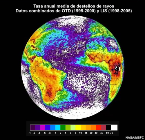
Descripción:
Annual global lightning flash rate density (number of flashes per square km per year) based on Microlab-1 OTD and TRMM LIS flashes observed and satellite viewing time from April 1995 to December 2002.
Nombre de archivo:
otd_lis_global_lightning_map.jpg
Créditos:
NASA/GSFC
Términos de derechos de autor:
Términos de uso estándar de COMET
|
Ver/guardar archivo .mp4
Descripción:
Annual global lightning flash rate density (number of flashes per square km per year) based on Microlab-1 OTD and TRMM LIS flashes observed and satellite viewing time from April 1995 to December 2002.
Nombre de archivo:
otd_lis_global_ltg_diurnal_cycle_ani.mp4
Créditos:
NASA/MSFC
Términos de derechos de autor:
Términos de uso estándar de COMET
|
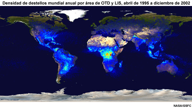
Descripción:
World map showing OTD (Optical Transient Detector) global lightning observations from April 12, 1995 to Decenber 31, 1999.
Nombre de archivo:
otd_mission_world.jpg
Créditos:
NASA/MSFC
Términos de derechos de autor:
Términos de uso estándar de COMET
|
|
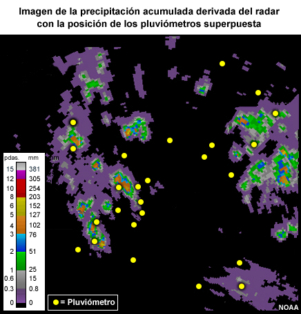
Descripción:
gauge locations on a radar rainfall image
Nombre de archivo:
radarrain_withgauge.jpg
Créditos:
NOAA
Términos de derechos de autor:
Términos de uso estándar de COMET
|
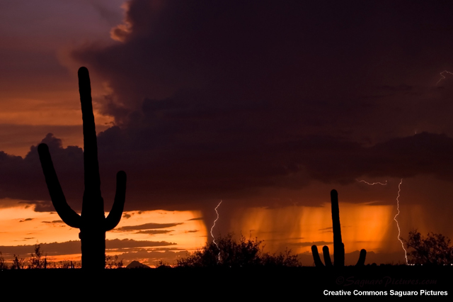
Descripción:
Backlighting at sunset causes dramatic views of this thunderstorm's rain-free base and updraft (at left), precipitation in the form of virga shafts (center and right), and lightning. In the desert southwest and western United States, lightning can be a substantial ignition threat.
Nombre de archivo:
rainshaft_lightning_sunset.jpg
Créditos:
Creative Commons Saguaro Pictures
Términos de derechos de autor:
Creative Commons Atribución-No comercial-Compartir igual 2.0 Genérica
|
|
|
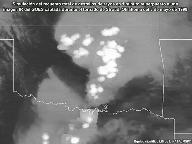
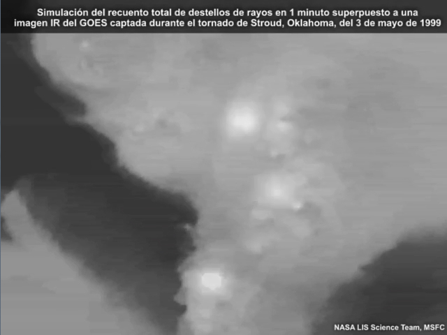
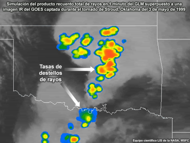
Descripción:
Simulated 1-Minute Total Lightning Flash Count over GOES IR Image During Stroud, OK Tornado on 3 May 1999
Nombre de archivo:
Simulated_GLM_Stroud_Tornado_flash_count_1.jpg
Créditos:
NASA LIS Science Team, MSFC
Términos de derechos de autor:
Términos de uso estándar de COMET
|
Descripción:
Simulated GLM 1-minute total lightning flash count product over GOES IR Image during Stroud, OK tornado on 3 May 1999
Nombre de archivo:
Simulated_GLM_Stroud_Tornado_flash_count_2.jpg
Créditos:
NASA LIS Science Team, MSFC
Términos de derechos de autor:
Términos de uso estándar de COMET
|
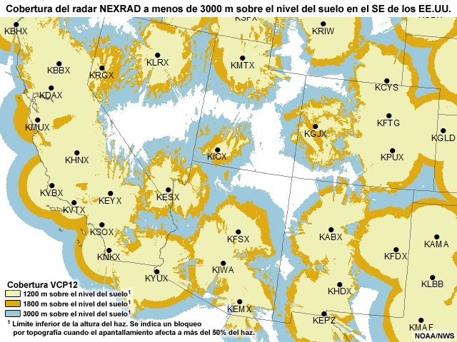
Descripción:
NEXRAD WSR-88D radar coverage over the southwestern United States as of 2011.
Nombre de archivo:
swus_nexrad_coverage2011.jpg
Créditos:
NOAA/NWS
Términos de derechos de autor:
Términos de uso estándar de COMET
|
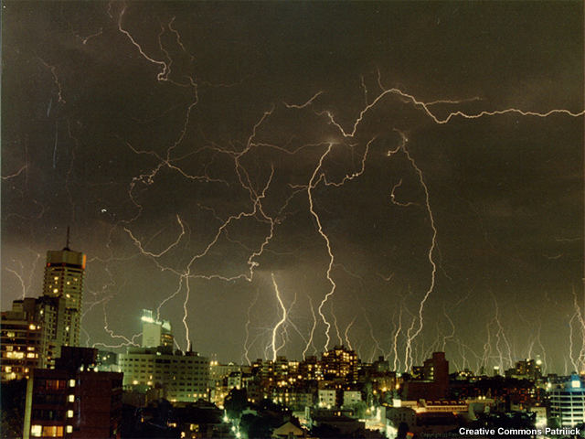
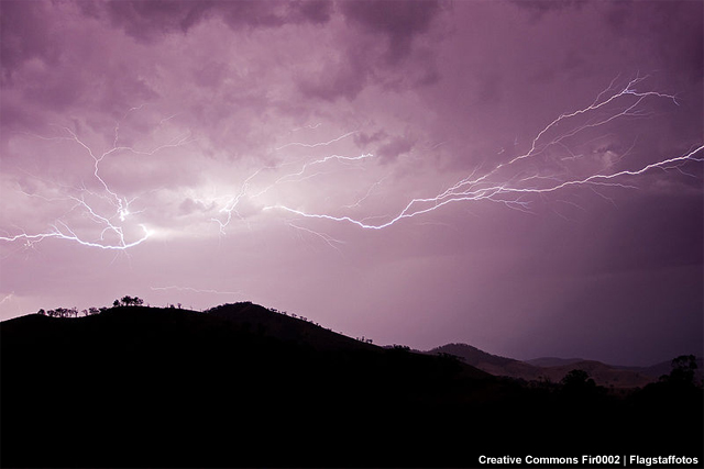
Descripción:
Photo of a severe storm with lightning in Sydney in 1991
Nombre de archivo:
thunderstorm_in_sydney.jpg
Créditos:
Creative Commons Patriiick
Términos de derechos de autor:
|
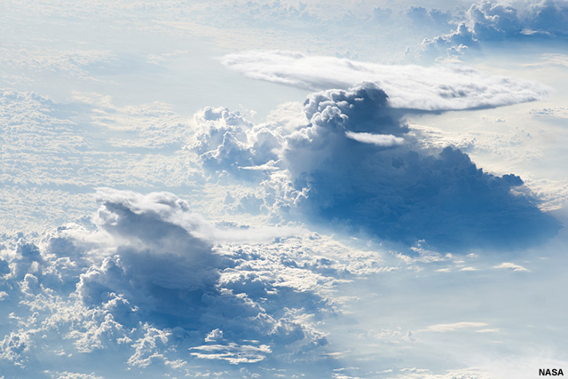
Descripción:
Photo of thunderstorms taken from the International Space Station.
Nombre de archivo:
thunderstorms_ISS022.jpg
Créditos:
NASA
Términos de derechos de autor:
Términos de uso estándar de COMET
|
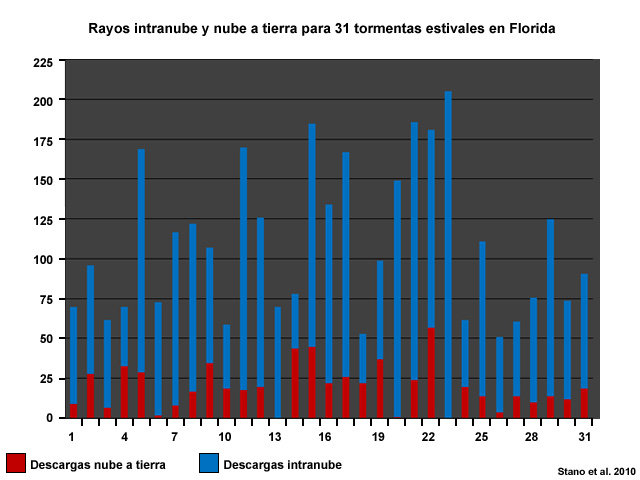
Descripción:
Total lightning activity for 31 Florida summertime thunderstorms from (May to September) 2000 to 2005.
Nombre de archivo:
total_lightning_FL_storms.jpg
Créditos:
Stano et al. 2010
Términos de derechos de autor:
Términos de uso estándar de COMET
|
Descripción:
TRMM infrared observations of a storm complex over the south central U.S. at 0629 UTC on May 14, 2005 showing TRMM PR (Precipitation Radar) satellite-derived reflectivity and lightning strikes over a TRMM VIRS infrared image.
Nombre de archivo:
TRMM_LIS_14may2005.jpg
Créditos:
NASA TRMM
Términos de derechos de autor:
Términos de uso estándar de COMET
|
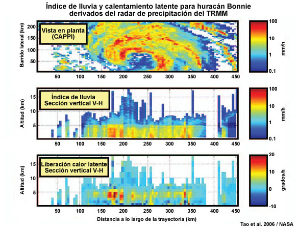
Descripción:
Plan view of near-surface rain rates for Hurricane Bonnie (22 Aug 1998); (middle) vertical cross section of rain-rate profiles along center of satellite track; (bottom) vertical cross section of latent heat profiles
Nombre de archivo:
trmmpr_latent_heat_GLMmod.jpg
Créditos:
Tao et al. 2006 /NASA
Términos de derechos de autor:
Términos de uso estándar de COMET
|
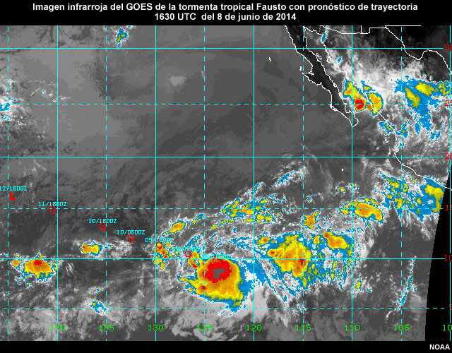
Descripción:
GOES-West IR image of tropical storm Fausto over the eastern Pacific ocean at 1630 UTC on July 8, 2014.
Nombre de archivo:
ts_fausto_goesir_08jul2014.jpg
Créditos:
NOAA
Términos de derechos de autor:
Términos de uso estándar de COMET
|
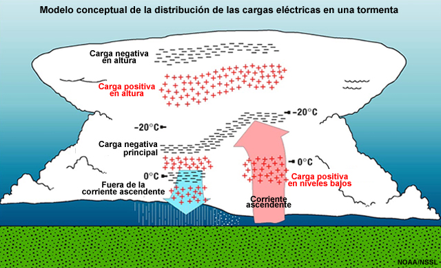
Descripción:
Conceptual model showing the electrical charge distribution inside deep convection (thunderstorms), developed by NSSL and university scientists.
Nombre de archivo:
tstm_lightning_structure.jpg
Créditos:
NOAA/NSSL
Términos de derechos de autor:
Términos de uso estándar de COMET
|
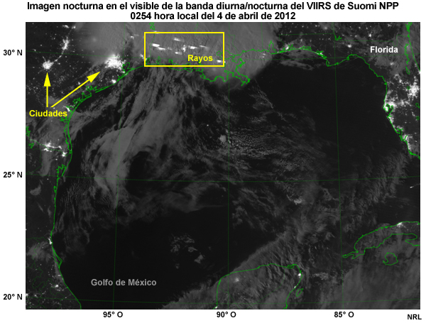
Descripción:
Suomi NPP VIIRS DNB Nighttime Visible image showing city lights, lightning, and gas flares in and around the Gulf of Mexico, 0254 Local Time on April 4, 2012.
Nombre de archivo:
viirs_dnb_lightning_GLMmod.jpg
Créditos:
NRL
Términos de derechos de autor:
Términos de uso estándar de COMET
|
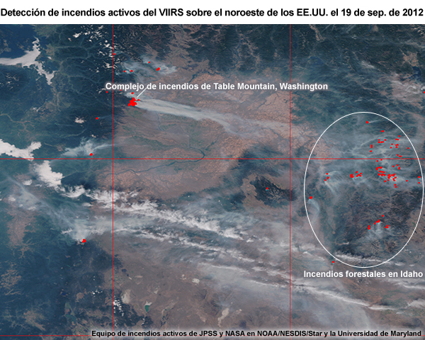
Descripción:
VIIRS active fire detection image showing the Table Mountain complex fires in Washington on 19 Sep 2012
Nombre de archivo:
viirs_fireprod_pacnw_19sep12.jpg
Créditos:
JPSS and NASA Active Fire team at NOAA/NESDIS/Star and the University of Maryland
Términos de derechos de autor:
Términos de uso estándar de COMET
|
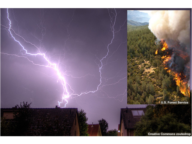
Descripción:
Two photos with one showing a wildfire (left) and the other lightning in a residential area (right).
Nombre de archivo:
wildfire_ltg_homes.jpg
Créditos:
(for left fire photo) U.S. Forest Service (for right lightning photo) Creative Commons zoutedrop
Términos de derechos de autor:
Creative Commons Atribución 2.0 Genérica
|