Media elements used in this module are protected by a variety of copyright licenses. Please use the "copyright terms" link associated with each item below for more information.
Description:
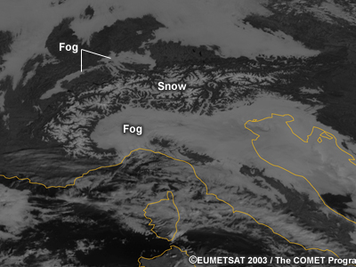
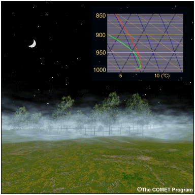
A visible satellite image of valley fog persistence. There is fog in many locations around an elevated terrain. The fog has dissipated in smaller valleys but persisted in several of the larger valleys.
File Name:
2003_11_20_1130_ch12_sat.jpg
Credits:
©EUMETSAT 2003/The COMET Program
Copyright Terms:
COMET Standard Terms
of Use
Description:
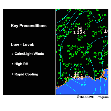
The key low-level ingredients required to generate a radiation fog are:
moisture, rapid cooling, and calm or light winds. The image also displays a geographical area near a coast and under a high pressure system.
File Name:
2bpix1.jpg
Credits:
©The COMET Program
Copyright Terms:
COMET Standard Terms
of Use
Description:
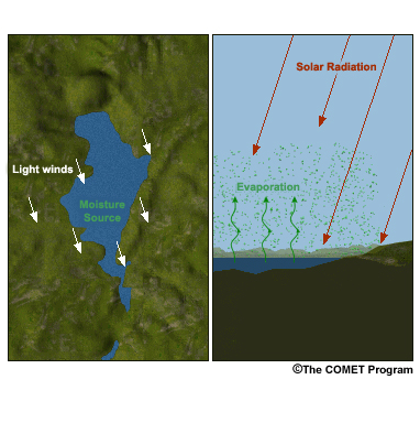
The key low-level ingredients required to generate a radiation fog are:
moisture, rapid cooling, and calm or light winds. The image displays a geographical area near a lake with light winds.
File Name:
2bpix2.jpg
Credits:
©The COMET Program
Copyright Terms:
COMET Standard Terms
of Use
Description:
Depiction of the earth-emitted radiation as it travels through the atmosphere. Less than 10% of the radiation can escape overcast skies (left)while clear skies allow 20-30% to escape the atmosphere (right).
File Name:
2cpix1.mp4
Credits:
©The COMET Program
Copyright Terms:
COMET Standard Terms
of Use
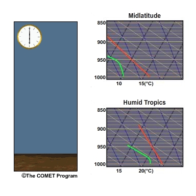
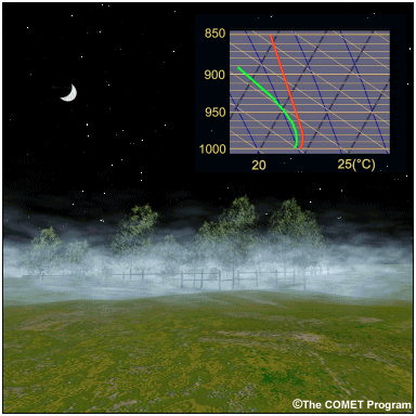
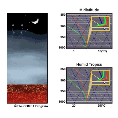
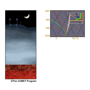
Description:
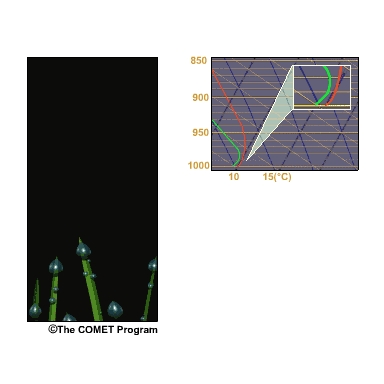
The near-surface layer cools as energy escapes the atmosphere, creating a shallow inversion near the surface. The image shows the inversion formation through a skew-T diagram and animation of radiation emitted over time.
File Name:
2cpix2.mp4
Credits:
©The COMET Program
Copyright Terms:
COMET Standard Terms
of Use

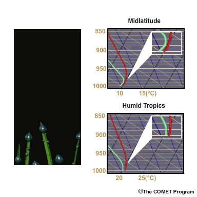
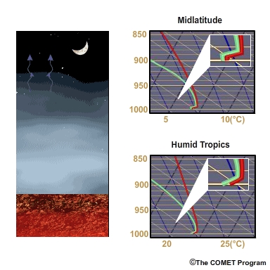
Description:
The near-surface layer cools as energy escapes the atmosphere, creating a shallow inversion near the surface. The image shows the inversion formation through a skew-T diagram and animation of radiation emitted over time. The inset map shows examples for the midlatitudes and for the humid tropics.
File Name:
2cpix2_carib.mp4
Credits:
©The COMET Program
Copyright Terms:
COMET Standard Terms
of Use
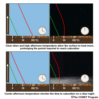
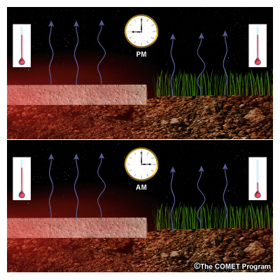
Description:
This image is divided into two parts. The top part shows how clear skies and high afternoon temperatures allow the surface to heat more, prolonging the period require to reach saturation. The bottom part show how cool afternoon temperatures shorten the time to saturation on a clear night.
File Name:
2cpix3.jpg
Credits:
©The COMET Program
Copyright Terms:
COMET Standard Terms
of Use
Description:
Cooling at the surface causes dew to form as long as moisture continues to be transported downward by weak turbulent diffusion.
File Name:
2dpix1.mp4
Credits:
©The COMET Program
Copyright Terms:
COMET Standard Terms
of Use
Description:
Cooling at the surface causes dew to form as long as moisture continues to be transported downward by weak turbulent diffusion.
File Name:
2dpix1_carib.mp4
Credits:
©The COMET Program
Copyright Terms:
COMET Standard Terms
of Use
Description:
As the surface-based layer stabilizes, weak turbulent diffusion ceases and droplets begin to form in the air above the surface.
File Name:
2dpix2.mp4
Credits:
©The COMET Program
Copyright Terms:
COMET Standard Terms
of Use
Description:
As the surface-based layer stabilizes, weak turbulent diffusion ceases and droplets begin to form in the air above the surface.
File Name:
2dpix2_carib.mp4
Credits:
©The COMET Program
Copyright Terms:
COMET Standard Terms
of Use
Description:
Highly conductive surfaces, such as pavement, cool more slowly after nightfall because heat conducted upward from below the surface offsets radiative cooling at the surface.
File Name:
2epix1.jpg
Credits:
©The COMET Program
Copyright Terms:
COMET Standard Terms
of Use
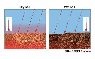
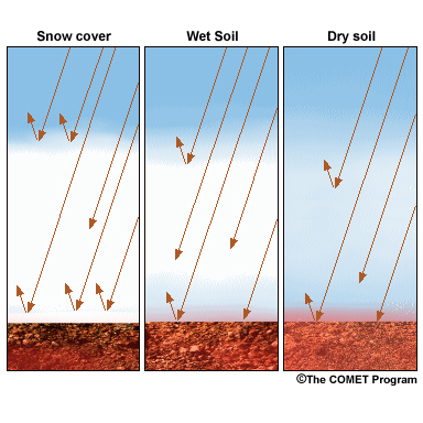
Description:
Heating difference between moist and dry ground. Wet soil does not heat up as much as dry soil during the daytime because it conducts heat more readily, and a significant portion of solar energy absorbed by wet soil contributes to evaporation.
File Name:
2epix2.jpg
Credits:
©The COMET Program
Copyright Terms:
COMET Standard Terms
of Use
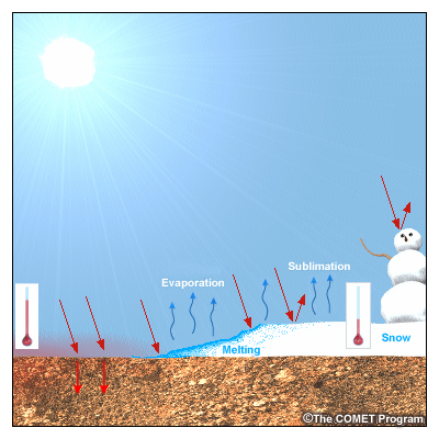
Description:
Surface snow cover is often associated with radiation fog. Snow absorbs much less solar radiation than other surfaces, and a portion of the energy that is absorbed is used for melting and/or sublimation.
File Name:
2epix3.jpg
Credits:
©The COMET Program
Copyright Terms:
COMET Standard Terms
of Use
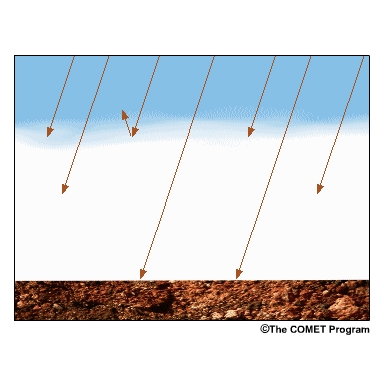
Description:
Snow cover also insulates the ground at night, limiting the upward flux of heat from beneath the snow.
File Name:
2epix4.jpg
Credits:
©The COMET Program
Copyright Terms:
COMET Standard Terms
of Use
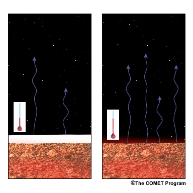
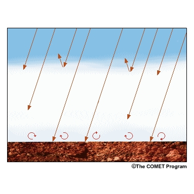
Description:
Nighttime radiative cooling occurs more quickly over snow cover than soil or vegetative surfaces
File Name:
2epix5.jpg
Credits:
©The COMET Program
Copyright Terms:
COMET Standard Terms
of Use
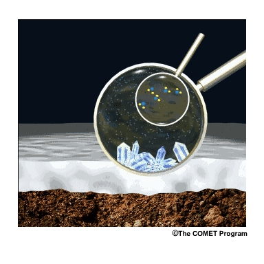
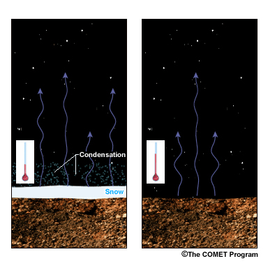
Description:
The presence of snow cover can also inhibit fog formation in situations where low-level moisture is shallow. Since water vapour pressure is lower around ice crystals than water droplets, rapid cooling can cause frost to grow at the expense of fog droplets and deplete the boundary layer of the excess moisture it needs to form fog.
File Name:
2epix6.mp4
Credits:
©The COMET Program
Copyright Terms:
COMET Standard Terms
of Use
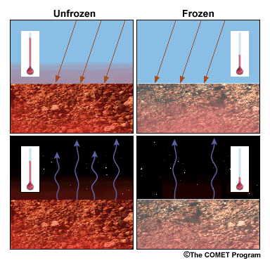
Description:
A frozen surface warms less than an unfrozen surface during the day. This occurs because the temperature of frozen ground cannot rise above the melting point until ice at the surface is thawed. In contrast, the temperature of unfrozen ground will start to rise immediately with daytime heating.
File Name:
2epix7.jpg
Credits:
©The COMET Program
Copyright Terms:
COMET Standard Terms
of Use
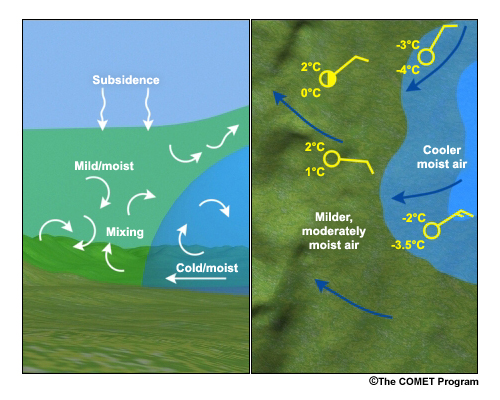
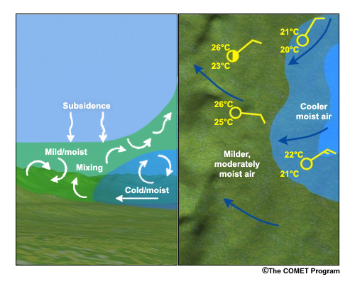
Description:
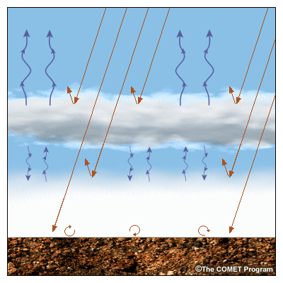
In this graphic, the left-hand side is a cross-section through the area, and the right-hand side is a plan view. The cooler air mass advecting in and replacing the milder and relatively drier air. As it advects in, the cooling of the surface and the upslope flow also force the air up the terrain feature. And finally, the large-scale subsidence aloft is conducive to the formation of fog and stratus in the region.
File Name:
2pnlavfg.jpg
Credits:
©The COMET Program
Copyright Terms:
COMET Standard Terms
of Use
Description:
In this graphic, the left-hand side is a cross-section through the area, and the right-hand side is a plan view. The cooler air mass advecting in and replacing the milder and relatively drier air. As it advects in, the cooling of the surface and the upslope flow also force the air up the terrain feature. And finally, the large-scale subsidence aloft is conducive to the formation of fog and stratus in the region. The inset map shows examples for the midlatitudes and for the humid tropics.
File Name:
2pnlavfg_carib.jpg
Credits:
©The COMET Program
Copyright Terms:
COMET Standard Terms
of Use
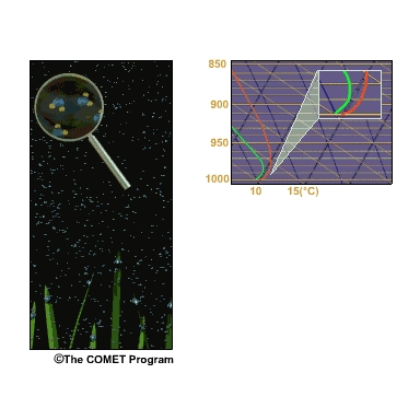
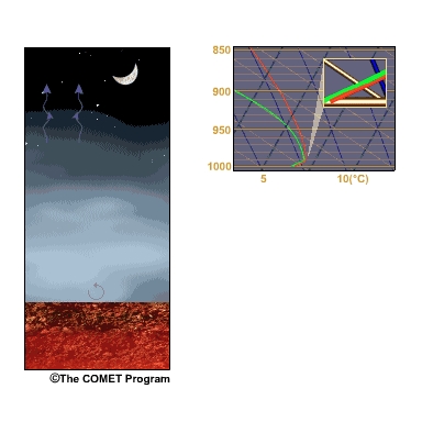
Description:
Radiative cooling progresses to the point that the air just above the ground becomes supersaturated and fog droplets form by condensation.
File Name:
3bpix1.jpg
Credits:
©The COMET Program
Copyright Terms:
COMET Standard Terms
of Use
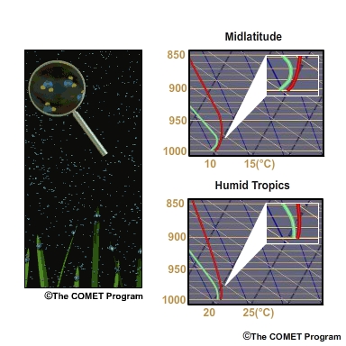
Description:
Radiative cooling progresses to the point that the air just above the ground becomes supersaturated and fog droplets form by condensation. The inset map shows examples for the midlatitudes and for the humid tropics.
File Name:
3bpix1_carib.jpg
Credits:
©The COMET Program
Copyright Terms:
COMET Standard Terms
of Use
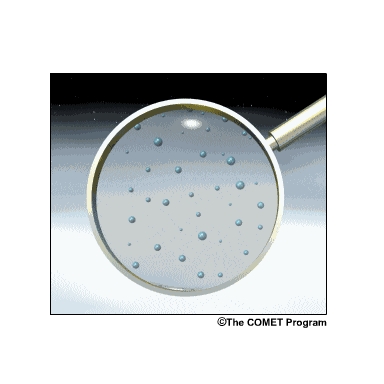
Description:
In some cases near the ocean or in polluted environments, droplet formation occurs prior to supersaturation since some hygroscopic nuclei, such as sea-salt particles, are active at saturation values below 100%.
File Name:
3bpix2.jpg
Credits:
©The COMET Program
Copyright Terms:
COMET Standard Terms
of Use
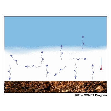
Description:
During the initial stage of fog formation, cooling continues at and near the surface until the fog depth reaches several meters, deep enough to begin to absorb and re-emit radiation originating from the earth
File Name:
3cpix1.mp4
Credits:
©The COMET Program
Copyright Terms:
COMET Standard Terms
of Use

Description:
Depending on the surface composition, the ground may continue to conduct heat to the surface. When it becomes warmer than the air just above it, weak low-level convective currents activate, causing the base of the near-surface inversion to rise.
File Name:
3cpix2.mp4
Credits:
©The COMET Program
Copyright Terms:
COMET Standard Terms
of Use
Description:
Depending on the surface composition, the ground may continue to conduct heat to the surface. When it becomes warmer than the air just above it, weak low-level convective currents activate, causing the base of the near-surface inversion to rise. The inset map shows examples for the midlatitudes and for the humid tropics.
File Name:
3cpix2_carib.mp4
Credits:
©The COMET Program
Copyright Terms:
COMET Standard Terms
of Use

Description:
Depending on the surface composition, the ground may continue to conduct heat to the surface. When it becomes warmer than the air just above it, weak low-level convective currents activate, causing the base of the near-surface inversion to rise. The inset map shows examples for the midlatitudes and for the humid tropics.
File Name:
3cpix2_carib.jpg
Credits:
©The COMET Program
Copyright Terms:
COMET Standard Terms
of Use
Description:
As the fog deepens, less and less radiation is able to escape from the surface and lower portion of the fog layer. The fog blankets the lower levels, restricting radiative heat loss
File Name:
3cpix3.mp4
Credits:
©The COMET Program
Copyright Terms:
COMET Standard Terms
of Use
Description:
As the fog deepens, less and less radiation is able to escape from the surface and lower portion of the fog layer. The fog blankets the lower levels, restricting radiative heat loss. The inset map shows examples for the midlatitudes and for the humid tropics.
File Name:
3cpix3_carib.mp4
Credits:
©The COMET Program
Copyright Terms:
COMET Standard Terms
of Use
Description:
Since upward heat flux from the ground reduces local RH at the surface, nocturnal radiation fog formation is delayed over highly conductive surfaces, such as pavement, and hastened over surfaces with low thermal conductivity, such as snow cover.
File Name:
3cpix4.mp4
Credits:
©The COMET Program
Copyright Terms:
COMET Standard Terms
of Use
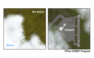
Description:
A two panel image. The Left panel show how fog forms over snow cover while little if any fog forms over dry ground. The right panel displays fog over the grassy areas near an airport while no fog is present over the airport's paved surfaces.
File Name:
3dpix1.jpg
Credits:
©The COMET Program
Copyright Terms:
COMET Standard Terms
of Use
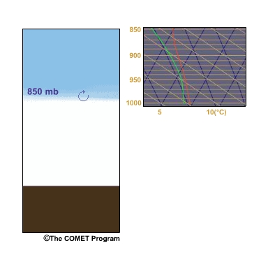
Description:
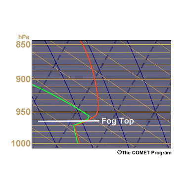
A skew-T diagram showing the top of the temperature inversion located 50 meters below the fog top. The inversion top is at 960 hPa.
File Name:
4bpix1.jpg
Credits:
©The COMET Program
Copyright Terms:
COMET Standard Terms
of Use
Description:
Since winds generally increase with height, a radiation fog layer typically deepens during its growth phase until it reaches a height where the winds are strong enough and induce enough fog-top mixing to halt the growth.
File Name:
4bpix2.mp4
Credits:
©The COMET Program
Copyright Terms:
COMET Standard Terms
of Use
Description:
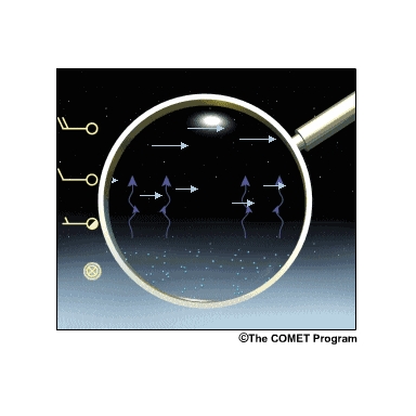
Conceptual diagram showing fogtop radiative cooling and droplet growth. The radiative heat loss is maximized when the layer immediately above the fog is relatively dry, the winds are weak, and there are no cloud layers aloft
File Name:
4cpix1.mp4
Credits:
©The COMET Program
Copyright Terms:
COMET Standard Terms
of Use
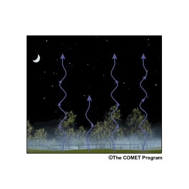
Description:
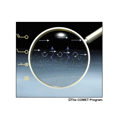
Entrainment of dry air via turbulent mixing at the fog top evaporates droplets. This process is enhanced by the presence of vertical wind speed shear at and above the top of the fog layer.
File Name:
4dpix1.mp4
Credits:
©The COMET Program
Copyright Terms:
COMET Standard Terms
of Use
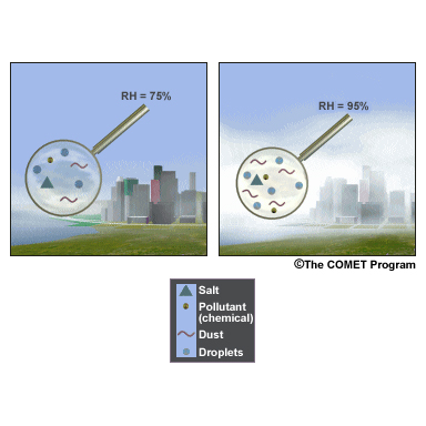
Description:
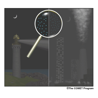
An illustration showing a coastal area and an urban area. Both contain a high concentration of condensation nuclei in the atmosphere that can enhance fog density. Multiple nuclei types, such as sea salt in combination with pollutant, can create the densest fogs.
File Name:
4epix1.jpg
Credits:
©The COMET Program
Copyright Terms:
COMET Standard Terms
of Use
Description:
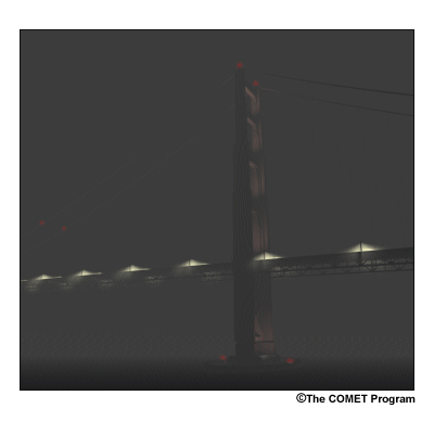
The most active condensation nuclei, such as sea-salt, are hygroscopic, or 'water-loving'. Air pollutants can also act as condensation nuclei. In this image dense fog forms around a bridge over coastal waters.
File Name:
4epix2.jpg
Credits:
©The COMET Program
Copyright Terms:
COMET Standard Terms
of Use
Description:
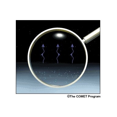
Conceptual diagram showing a low cloud layer just above a surface fog layer. Radiative cooling from the top of the cloud layer is greater than from the top of the fog layer.
File Name:
4fpix1.mp4
Credits:
©The COMET Program
Copyright Terms:
COMET Standard Terms
of Use
Description:
The lower the level of an overlying cloud layer, the more it can reduce radiative cooling and condensate production at fog top.
File Name:
4fpix2.jpg
Credits:
©The COMET Program
Copyright Terms:
COMET Standard Terms
of Use
Description:
Snow cover reduces the thermal conductivity of the surface, restricting the upward heat flux from the ground during this phase. This image shows the denser fog over snow-covered ground when compared with fog over dry soil.
File Name:
4gpix1.jpg
Credits:
©The COMET Program
Copyright Terms:
COMET Standard Terms
of Use
Description:
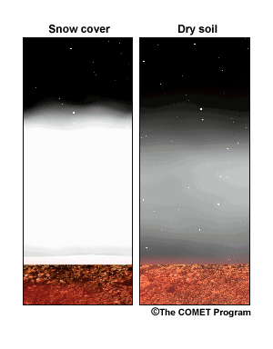
Snow cover also reflects more solar radiation than other surface types, which slows diurnal warming after sunrise. This image shows that dry soil absorbs more radiation than snow-covered ground and wet soil. Wet soil absorbs more radiation than snow-covered ground too.
File Name:
4gpix2.jpg
Credits:
©The COMET Program
Copyright Terms:
COMET Standard Terms
of Use

Description:
Events where fog takes longer than a day to dissipate occur in the more geographically protected areas, such as mountain valleys. The season also influences the length of this phase through such factors as sun angle, average wind speed, snow cover, ground moisture, and vegetation.
File Name:
5bpix1.mp4
Credits:
©The COMET Program
Copyright Terms:
COMET Standard Terms
of Use
Description:
During the daytime, radiation from the sun is absorbed by the ground, even when there is an intervening layer of fog. As the ground warms, it heats a thin skin of air in contact with the surface through conduction.
File Name:
5cpix1.mp4
Credits:
©The COMET Program
Copyright Terms:
COMET Standard Terms
of Use
Description:
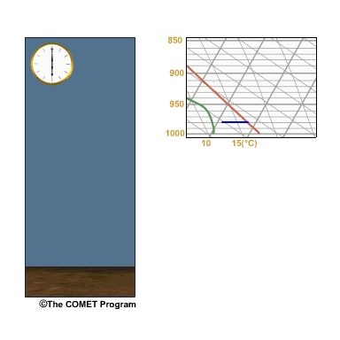
The relative humidity begins to decrease, slowing the formation of fog droplets and eventually evaporating existing droplets. As the fog thins, the warming process accelerates, allowing more solar radiation to reach the ground.
File Name:
5cpix2.mp4
Credits:
©The COMET Program
Copyright Terms:
COMET Standard Terms
of Use
Description:
Air warms as it absorbs the heat energy, causing its temperature to rise and relative humidity to fall.
File Name:
5dpix1.mp4
Credits:
©The COMET Program
Copyright Terms:
COMET Standard Terms
of Use
Description:
Fog droplets vary in size, with smaller droplets settling more slowly than larger ones.
File Name:
5epix1.mp4
Credits:
©The COMET Program
Copyright Terms:
COMET Standard Terms
of Use
Description:
A fog layer's capping inversion is often accompanied by a layer of significant vertical wind shear. Turbulent mixing of warmer and drier air into the top of the fog layer can reduce relative humidity in that layer and lower the inversion.
File Name:
5fpix1.mp4
Credits:
©The COMET Program
Copyright Terms:
COMET Standard Terms
of Use
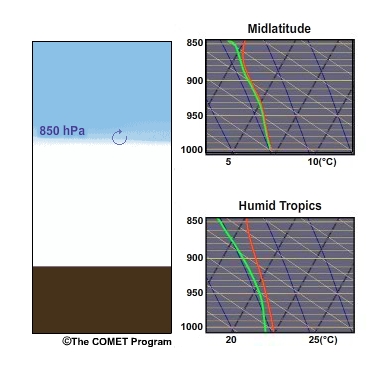
Description:
A fog layer's capping inversion is often accompanied by a layer of significant vertical wind shear. Turbulent mixing of warmer and drier air into the top of the fog layer can reduce relative humidity in that layer and lower the inversion. The inset map shows examples for the midlatitudes and for the humid tropics.
File Name:
5fpix1_carib.mp4
Credits:
©The COMET Program
Copyright Terms:
COMET Standard Terms
of Use
Description:
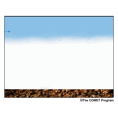
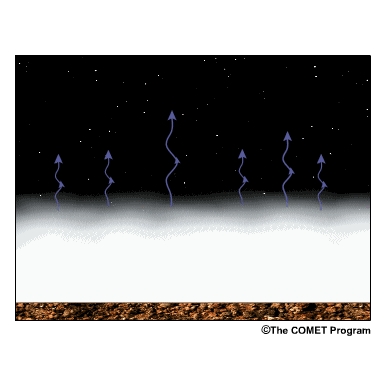
Introduction of moderate to strong low-level winds can cause fog to dissipate both at the fog top and near the surface. At the fog top, winds entrain warmer, drier air from aloft into the fog.
File Name:
5gpix1.mp4
Credits:
©The COMET Program
Copyright Terms:
COMET Standard Terms
of Use
Description:
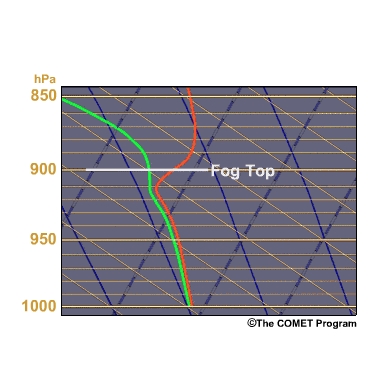
A skew-T diagram shows how cold advection above the fog layer can also dissipate fog by weakening the fog-top inversion, which enhances mixing processes. The cold air shrink the fog top from 900 hPa to 980 hPa.
File Name:
5gpix2.mp4
Credits:
©The COMET Program
Copyright Terms:
COMET Standard Terms
of Use
Description:
When a broken or overcast layer of mid-level or a thick layer of upper-level clouds is introduced, fog-top cooling decreases because less radiation is able to escape the atmosphere.
File Name:
5hpix1.mp4
Credits:
©The COMET Program
Copyright Terms:
COMET Standard Terms
of Use
Description:
Conceptual graphic of the evolution of a radiation fog inversion
File Name:
6.3.mp4
Credits:
©The COMET Program
Copyright Terms:
COMET Standard Terms
of Use
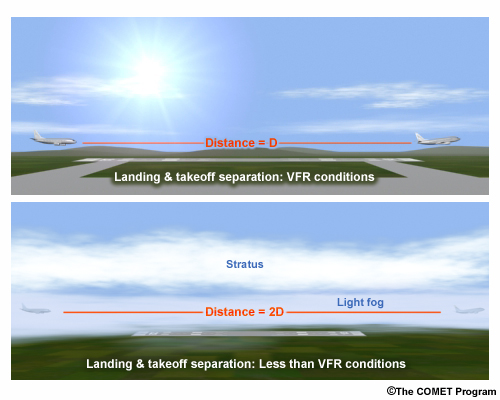
Description:
Graphic showing landing and takoff separation in less than VFR conditions
File Name:
aprchoff.jpg
Credits:
©The COMET Program
Copyright Terms:
COMET Standard Terms
of Use
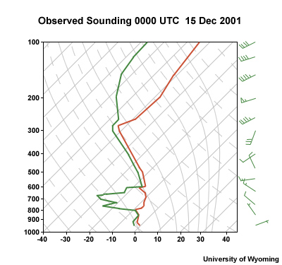
Description:
File Name:
apx121501_00.jpg
Credits:
University of Wyoming
Copyright Terms:
COMET Standard Terms
of Use
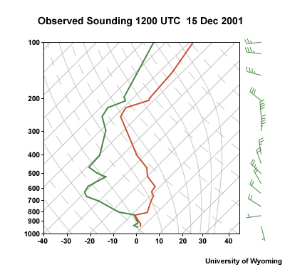
Description:
File Name:
apx121501_12.jpg
Credits:
University of Wyoming
Copyright Terms:
COMET Standard Terms
of Use
Description:
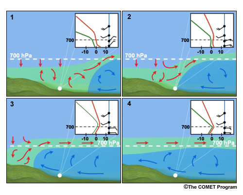
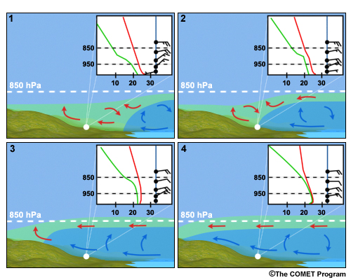
Evolution of a sounding for advection fog. The graphic is divided in four panels. We see that in the change of the temperature profile in the skew-T diagram between the first panel and the second panel. As that cold air continues to move into the area (3), the vertical structure of the atmosphere continues to modify; and we see the inversion set up in the boundary layer. There are still relatively strong winds in the boundary layer. In the last panel (4), the winds have decreased, and there?s a saturated region with an inversion that is trapping that moisture in the boundary layer.
File Name:
avfogseq.jpg
Credits:
©The COMET Program
Copyright Terms:
COMET Standard Terms
of Use
Description:
Evolution of a sounding for advection fog in the humid, tropical easterlies. The prevailing trade winds bring air from the ocean. The land is cooled by radiation over night. The graphic is divided in four panels. We see the change of the temperature profile in the skew-T diagram between the first panel and the second panel. As that moist air continues to move into the area (3), the vertical structure of the atmosphere continues to modify; and we see the inversion set up in the boundary layer. In the last panel (4), there is a saturated region with an inversion that is trapping that moisture in the boundary layer.
File Name:
avfogseq_carib.jpg
Credits:
Copyright Terms:
COMET Standard Terms
of Use
Description:
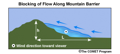
The vertical structure is depicted in the cross section, which shows the blocked region to be a wedge of air near the mountains, capped by a sloping layer of higher static stability (the blue line). The air is forced up and over the blocked region. The air within the blocked region simply flows along the barrier toward lower pressure.
File Name:
blkxsect.jpg
Credits:
©The COMET Program
Copyright Terms:
COMET Standard Terms
of Use
Description:
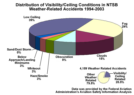
Distribution of Visibility/Ceiling Conditions in NTSB Weather-Related Accidents
File Name:
categories_CIG_specific.gif
Credits:
Data was provided by the Federal Aviation Administration's Aviation Safety Information Analysis and
Copyright Terms:
COMET Standard Terms
of Use
Description:
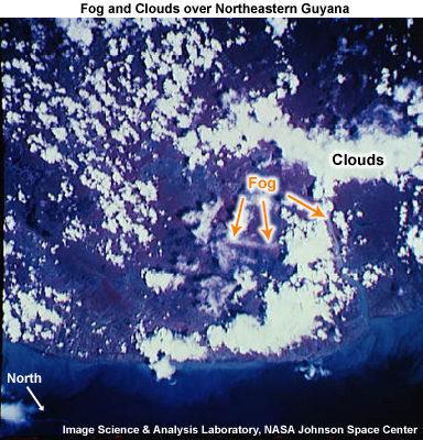
Photograph of fog and clouds over the Demerara River and capital city of Georgetown, Guyana (taken from the Space Station).
File Name:
demerara_guyana_nasa_STS069_737_54_carib.jpg
Credits:
Image courtesy of the Image Science & Analysis Laboratory, NASA Johnson Space Center
Copyright Terms:
COMET Standard Terms
of Use
Description:
Animation showing impact of ceilings and visibility TAFs
File Name:
DLAC_intro_5.mp4
Credits:
©The COMET Program
Copyright Terms:
COMET Standard Terms
of Use
Description:
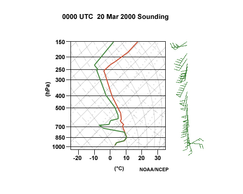
A skew-T sounding suggesting the presence of strong and veering winds with height in a fog event.
File Name:
dvn2000.jpg
Credits:
NOAA/NCEP
Copyright Terms:
COMET Standard Terms
of Use
Description:
A skew-T sounding suggesting the presence of strong and veering winds with height in a fog event.
File Name:
dvn2000.jpg
Credits:
NOAA/NCEP
Copyright Terms:
COMET Standard Terms
of Use
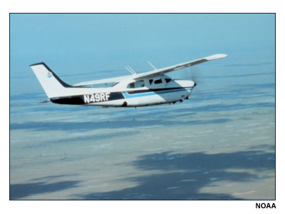
Description:
Photo of small airplane over flat terrain with cloud shadows below.
File Name:
fly00378.jpg
Credits:
NOAA
Copyright Terms:
COMET Standard Terms
of Use
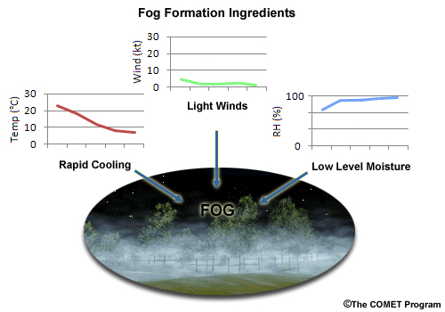
Description:
Fog formation ingredients: rapid cooling, light winds, low level moisture.
File Name:
fog_ingredients.jpg
Credits:
©The COMET Program
Copyright Terms:
COMET Standard Terms
of Use
Description:
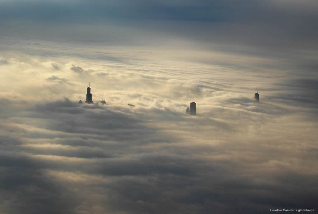
A thick layer of low clouds covers the Chicago skyline in this view from a plane. The tops of four skyscrapers are visible through the clouds. Three other buildings are barely discerned.
File Name:
low_clouds_chicago.jpg
Credits:
Creative Commons glennharper
Copyright Terms:
Creative
Commons Attribution 2.0 Generic
Description:
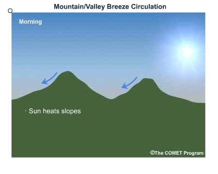
Mountain and valley breezes are components of a local wind pattern that routinely develops along mountain slopes. During the day the valley breeze blows upslope; at night it switches to downslope.
File Name:
mtnvly_0001.htm
Credits:
©The COMET Program
Copyright Terms:
COMET Standard Terms
of Use
Description:
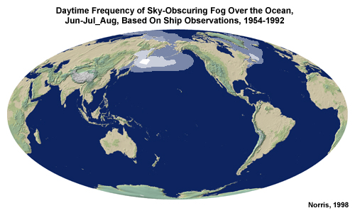
Daytime frequency of sky-obscuring fog over the ocean for June, July, and August based on ship observations from 1954 to 1992. The major areas are in the northern Pacific and Atlantic.
File Name:
ocean_fog_1.jpg
Credits:
Norris, 1998
Copyright Terms:
COMET Standard Terms
of Use
Description:
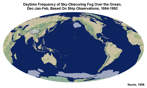
Daytime frequency of sky-obscuring fog over the ocean for December, January, and February based on ship observations from 1954 to 1992. The major areas are in the northwest Pacific Ocean and areas surrounding Antarctica.
File Name:
ocean_fog_2.jpg
Credits:
Norris, 1998
Copyright Terms:
COMET Standard Terms
of Use

Description:
Conceptual animation of post-cold frontal events
File Name:
postcold_0001.htm
Credits:
©The COMET Program
Copyright Terms:
COMET Standard Terms
of Use
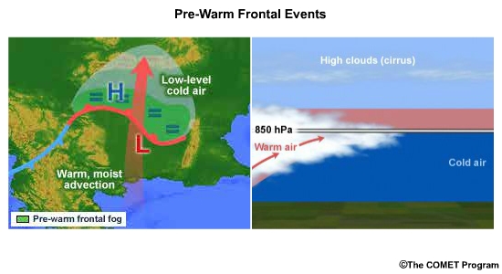
Description:
Conceptual animation of pre-warm frontal events
File Name:
prewarm_0001.htm
Credits:
©The COMET Program
Copyright Terms:
COMET Standard Terms
of Use
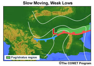
Description:
Conceptual graphic of slow moving, non-intensifying lows or open waves
File Name:
prewarm1.jpg
Credits:
©The COMET Program
Copyright Terms:
COMET Standard Terms
of Use
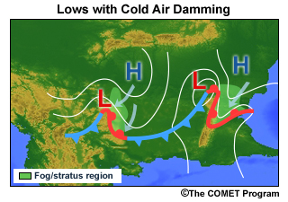
Description:
Conceptual graphic of lows with cold air damming
File Name:
prewarm2.jpg
Credits:
©The COMET Program
Copyright Terms:
COMET Standard Terms
of Use
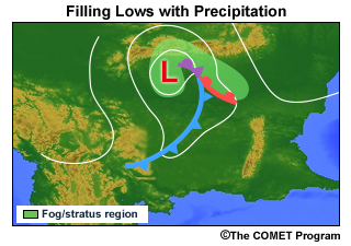
Description:
Conceptual graphic of filling lows that are still producing rainfall.
File Name:
prewarm3.jpg
Credits:
©The COMET Program
Copyright Terms:
COMET Standard Terms
of Use
Description:
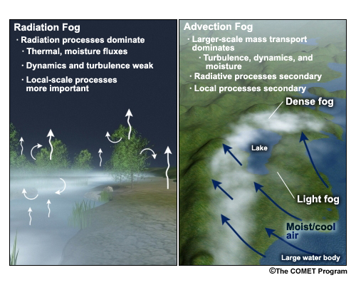
Conceptual graphic of the processes involved in advection and radiation fog. For radiation fog: radiation processes like thermal and moisture fluxes dominate. Dynamics and turbulence are weak. Local-scale processes are more important. For advection fog: Large-scale mass transport dominates turbulence, dynamics, and moisture. Radiative and local processes are secondary.
File Name:
radavfog.jpg
Credits:
©The COMET Program
Copyright Terms:
COMET Standard Terms
of Use
Description:
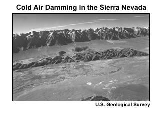
Cold air damming in the Sierra Nevada in the US.
File Name:
sierranv.jpg
Credits:
U.S. Geologic Survey
Copyright Terms:
COMET Standard Terms
of Use
Description:
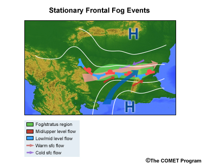
Conceptual graphic of stationary frontal fog events
File Name:
statnary.jpg
Credits:
©The COMET Program
Copyright Terms:
COMET Standard Terms
of Use
Description:
A Skew-T sounding valid: 12 UTC December, 2002.
File Name:
top12skw.jpg
Credits:
NOAA/NCEP
Copyright Terms:
COMET Standard Terms
of Use
Description:
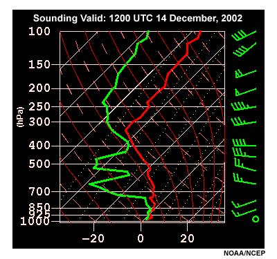
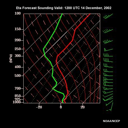
Eta Forecast Sounding Valid: 1200 UTC 14 December through 0000 UTC 15 December, 2002
File Name:
topskew_0001.htm
Credits:
NOAA/NCEP
Copyright Terms:
COMET Standard Terms
of Use
Description:
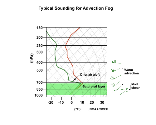
Typical sounding for advection fog
File Name:
typafgsn.jpg
Credits:
NOAA/NCEP
Copyright Terms:
COMET Standard Terms
of Use
Description:
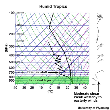
Example sounding for advection fog in regions of prevailing humid tropical easterlies
File Name:
typafgsn_carib.jpg
Credits:
NOAA/NCEP
Copyright Terms:
COMET Standard Terms
of Use
Description:
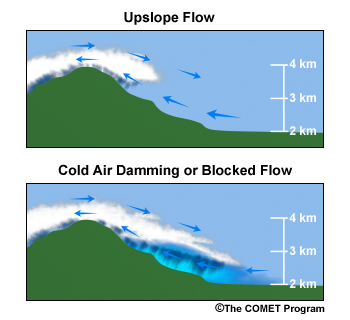
Purely upslope flow without blocking (shown in the top panel) results when there is sufficient flow for the air to make it over the terrain barrier and down the leeward side. In these cases, the air may not be as stratified as in blocked cases, and the upslope flow will be stronger. However, the mechanical uplift provided by the mountain barrier can still cause lower ceilings, fog, and precipitation. Much of the impact on ceilings and visibility is found near the crest of the terrain barrier.
File Name:
upslocad.jpg
Credits:
©The COMET Program
Copyright Terms:
COMET Standard Terms
of Use