Produced by The COMET® Program
Introduction
Stability/instability
Inversions
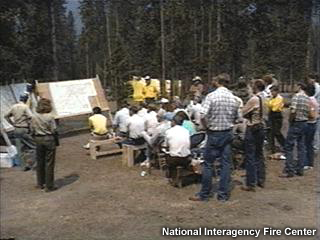
Operations
Knowing your Customer
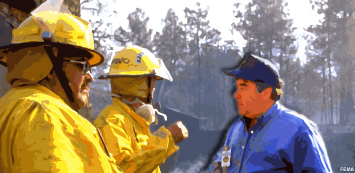
Click the arrow above to play the audio.
Click all the appropriate questions to ask the fire boss and click Done.
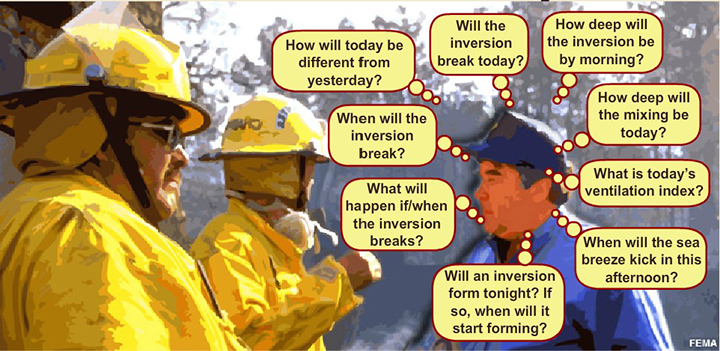
The correct answers are b, e, f, g, i, j, l, m, n
Inappropriate question to ask:
| Question | Reason |
|---|---|
| What is the fire danger rating for this area today? | No, the fire boss will likely be well aware of such ratings and will not look to the fire weather forecaster for such information. |
| Will low-level easterly flow prevent the inversion from mixing out today? | No, although this is an example of information that is very helpful to provide to the fire boss, you must include your interpretation of how these conditions will affect fire weather parameters. |
| Will jet streak-related vertical circulations increase baroclinicity in our area today? | No. A fire boss is unlikely to ask such a technical meteorological question. It is your job to interpret atmospheric mechanics and the potential impact on fire weather parameters so that the fire boss can make good operational decisions. |
| What is the Haines Index? | No, most fire bosses are more interested in timing and consequence information, not specific numerical values. Your job is one of providing interpretive information about atmospheric conditions and expected changes. |
| How dry is the 500-700 hPa air expected to advect into our area today? | No. Although you must be aware of how dry the mid-level air is, the fire boss is more interested in your interpretation of how this change will affect overall atmospheric conditions. |
| What are the 10- and 100-hr fuel moistures in our area today? | No, the fire boss will likely be well aware of such values and will not look to the fire weather forecaster for such information. |
Haines Index
Introduction
What is HI?
Calculation
Consistency
Interpretation
Haines Game
Welcome
Welcome to the Haines Game!
This 3-part game will help you become more familiar with the Haines Index. You'll learn how to calculate it and how to put HI values into context within a variety of atmospheric profiles. You'll learn how to distinguish, at a glance, low-Haines from high-Haines soundings and how to separate the "wheat from the chaff" - that is to distinguish bonafide extreme Haines signatures from similar, but much weaker signatures. Finally, you'll start to become "Haines Literate" as you analyze soundings for clues to support development of large convective plumes and erratic fire behavior.
Continue onto the next page to begin.
Then, click through the rest of the game segments in order.
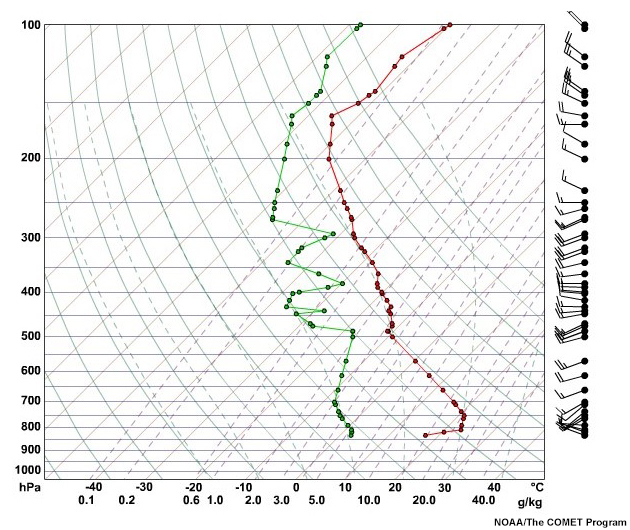
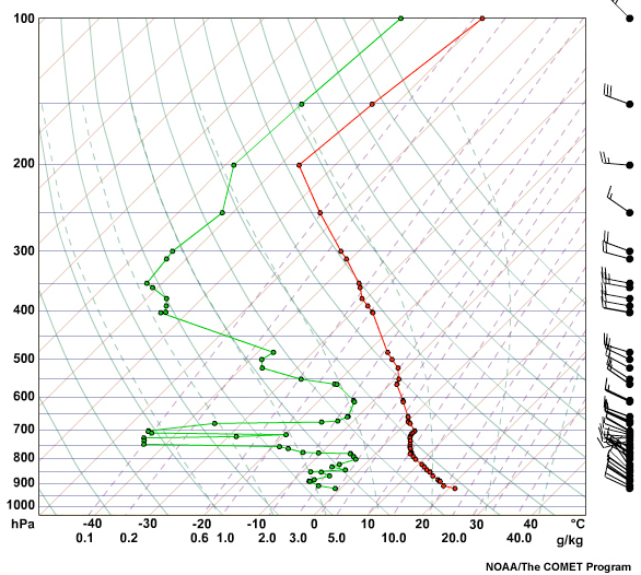
Hand Calculation
Question 1 of 3
700 hPa Temperature: 9C
850 hPa Temperature: 19.4C
850 hPa Dewpoint: -0.6C
Boise Elevation is 2730 ft.
How to Calculate HI
What are the Haines values A and B for this sounding?
(Choose the best answer from the dropdown box, then click
Done.)
Since the elevation at Boise is 832 m or 2730 ft, the Haines
Index should be
calculated for the values in the 1000-3000 ft, or mid-level
elevation range.
For this range, pressure level 1 (p1) is 850 hPa, while pressure
level 2
(p2) is 700 hPa. In this example, Tp1 = 19.4 C, Tp2 = 9 C, and
Tdp1 = -0.6
C.
Stability Term (A)
A = Tp1 -Tp2
= 19.4 - 9
= 10.4
A 10.4 C temperature difference is assigned the Haines Index of
3.
Moisture Term (B)
B = Tp1 - Tdp1
= 19.4 - -0.6
= 20
A 20 C T - Td difference is assigned a Haines Index of 3.
Haines Index
HI = A + B
= 3 + 3
= 6
In this example, both the stability term and the moisture term
had maximum
values of 3, although the stability term was borderline at 10.4
C (10 C is
the threshold between 2 and 3 for mid-level elevations). This
combination of
instability and very dry conditions at 850 hPa suggests a high
potential for
rapid fire growth.
Note, however, that although Boise is a mid-level site, it is
often used for
high-level calculations because of the higher elevations in much
of the
surrounding terrain.
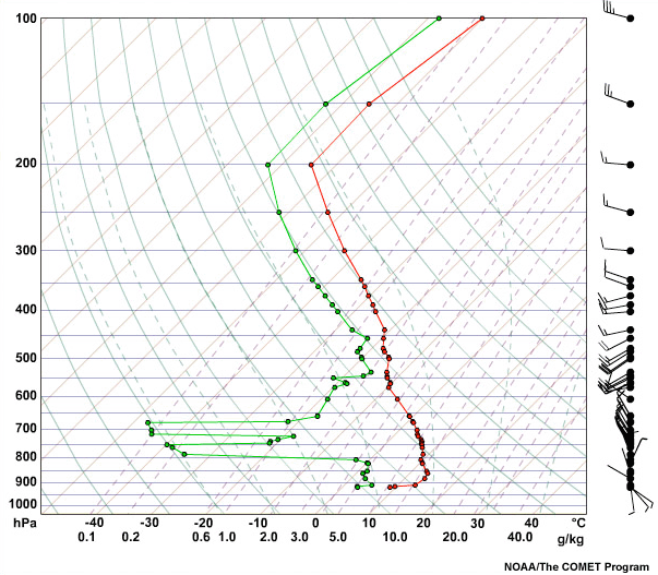
Question 2 of 3
500 hPa Temperature: -16C
700 hPa Temperature: -3C
700 hPa Dewpoint: -7C
Great Falls Elevation is 3711 ft.
How to Calculate HI
What are the Haines values A and B for this sounding?
(Choose the best answer from the dropdown box, then click
Done.)
Since the elevation at Great Falls is 1131 m or 3711 ft, the
Haines Index should be calculated for values in the 3000+ ft, or
high elevation range. For this range, pressure level 1 (p1) is
700 hPa, while pressure level 2 (p2) is 500 hPa. In this
example, Tp1 = -3 C, Tp2 = -16 C, and Tdp1 = -7 C.
Stability Term (A)
A = Tp1 -Tp2
= -3 - -16
= 13
A 13 C temperature difference is assigned the Haines Index of
1.
Moisture Term (B)
B = Tp1 - Tdp1
= -3 - -7
= 20
A 4 C T - Td difference is assigned a Haines Index of 1.
Haines Index
HI = A + B
= 1 + 1
= 2
Both the stability and the moisture terms are low on this
example, resulting in a Haines Index of 2, which corresponds to
very low potential for rapid fire growth.
Question 3 of 3
500 hPa Temperature: -9.3C
700 hPa Temperature: 16.2C
700 hPa Dewpoint: -7.8C
Riverton Elevation is 5587 ft.
How to Calculate HI
What are the Haines values A and B for this sounding?
(Choose the best answer from the dropdown box, then click
Done.)
Since the elevation at Riverton is 1703 m or 5587 ft, the
Haines Index should be calculated for values in the 3000+ ft, or
high elevation range. For this range, pressure level 1 (p1) is
700 hPa, while pressure level 2 (p2) is 500 hPa. In this
example, Tp1 = 16.2 C, Tp2 = -9.3 C, and Tdp1 = -7.8 C.
Stability Term (A)
A = Tp1 -Tp2
= 16.2 - -9.3
= 25.5
A 25.5 C temperature difference is assigned the Haines Index of
3.
Moisture Term (B)
B = T700 hPa - Td700 hPa
= 16.2 - -7.8
= 24
A 24 C T - Td difference is assigned a Haines Index of 3.
Haines Index
HI = A + B
= 3 + 3
= 6
This sounding generates a Haines Index of 6, which corresponds
to high potential for rapid fire growth. The 700-500 hPa layer
is nearly dry-adiabatic, and the 700 hPa level is extremely dry.
This mid-level air could cause a rapid increase in fire behavior
if it mixes to the surface.
Congratulations, you have completed the "Hand Calculation"
section of the Haines Game.
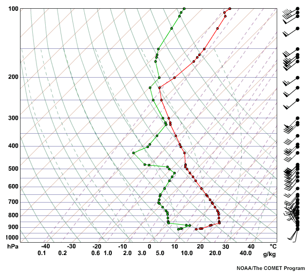
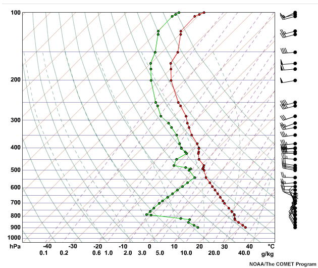
2-4-6
For this part of the Haines Game you're going to try your hand at distinguishing soundings that have 2, 4, and 6 Haines Indices.
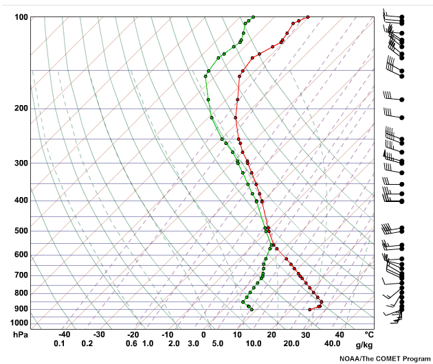
Question 1 of 3
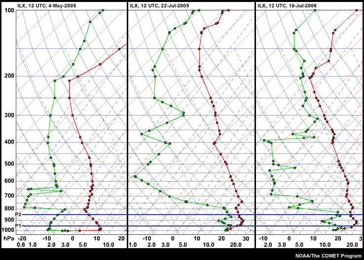
The three soundings above are from Lincoln, IL (ILX) with an elevation
of 178 m or 584 ft. The low elevation Haines Indices are 2, 4, and 6.
Which is which?
(Choose the best answer from the dropdown box, then click
Done.)
The ILX sounding from 22-Jul-2005 (center) has a very low Haines
Index of 2 because of the influence of the inversion extending
from the surface to 900 hPa on term A. The very moist conditions
at 850 hPa combine with the stability term to yield a Haines
Index of 2.
The sounding from 4-May-2005 (left) shows dry air and a nearly
dry adiabatic lapse rate above a strong, but shallow surface
inversion. The resulting Haines Index is 6 indicating high
potential for rapid fire growth.
The sounding from 10-Jul-2006 (right) shows a Haines Index of 4,
which corresponds to low potential for rapid fire growth. This
sounding looks similar to that of 22-Jul-2005, with the main
difference being less stable air between 950 and 850 hPa. The
air at 850 hPa is also drier than in the 22-Jul-2005 sounding.
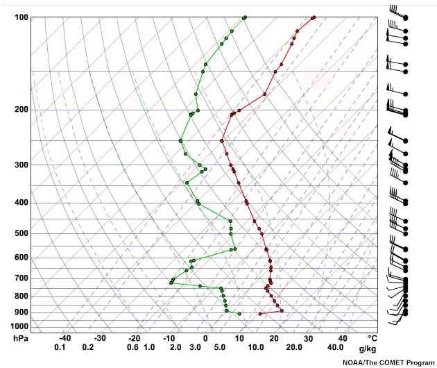
Question 2 of 3
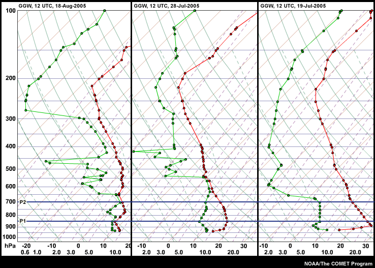
The three soundings above are from Glasgow, MT (GGW) with an elevation
of 693 m or 2274 ft. The low elevation Haines Indices are 2, 4, and 6.
Which is which?
(Choose the best answer from the dropdown box, then click
Done.)
The 19-Jul-2005 sounding (right) has a Haines Index of 6 because of both the steep lapse rate (term A) and the dry air at 850 hPa (term B). In contrast the conditions on 28-Jul-2005 (center) are more stable and less dry, resulting in HI of 4, with even more stable and moist conditions seen in the 18-Aug-2005 sounding (left) and resulting in HI of 2.
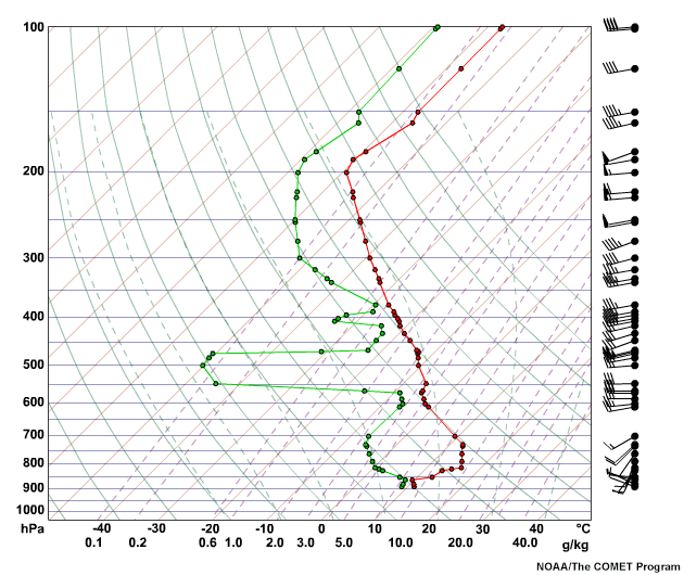
Question 3 of 3
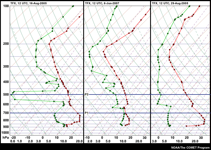
The three soundings above are from Great Falls, MT (TFX) with an
elevation
of 1131 m or 3711 ft. The low elevation Haines Indices are 2, 4, and 6.
Which is which?
(Choose the best answer from the dropdown box, then click
Done.)
The 16-Aug-2005 sounding (left) shows somewhat more stable
conditions between 600 and 500 hPa, and less dry conditions at
700 hPa. Both resulted in a HI of 4.
The 6-Jun-2007 sounding (center) shows substantially moister
conditions at 700 hPa and an elevated stable layer, which
resulted in a very low HI of 2.
The 29-Aug-2005 sounding (right) has the HI of 6 because of dry
conditions at 700 hPa and the relatively unstable lapse rate.
Congratulations, you have completed the "2-4-6" section of the
Haines Game.
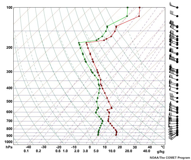
Five and Sixes
For this part of the Haines Game you're going to sharpen your skills as you learn to pick out a strong "6" from two moderate "5" soundings.
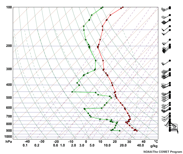
Question 1 of 3
Examine the soundings from Riverton, Wyoming (elevation 1703 m or 5587
ft). One of the three soundings above has a Haines Index of 6, while the
other two soundings have Haines Indices of 5. Which one is the six?
(Choose the best answer from the dropdown box, then click
Done.)
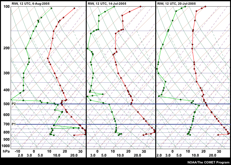
The 14-Jul-2005 sounding (center) is the six in this group. This sounding stands out from the others because it has both very dry conditions at 700 hPa and a nearly dry adiabatic lapse rate from 700 to 500 hPa. In contrast, both the 6-Aug-2005 sounding (left) and the 20-Jul-2005 (right) are not as dry at 700 hPa.
Question 2 of 3
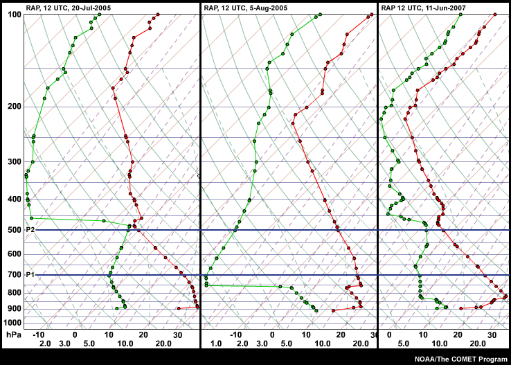
Examine the soundings from Rapid City, SD (elevation 966 m or 3169
ft). One of the three soundings above has a Haines Index of 6, while the
other two soundings have Haines Indices of 5. Which one is the six?
(Choose the best answer from the dropdown box, then click
Done.)
The 20-Jul-2005 sounding (left) is the six in this group. This
sounding stands out from the others because it has very dry
conditions at 700 hPa and its nearly dry adiabatic lapse rate
between 700 and 500 hPa.
The sounding from 5-Aug-2005 (center) has very dry air, but has
a less unstable lapse rate, while the 11-Jun-2007 sounding
(right) is not as dry at 700 hPa.
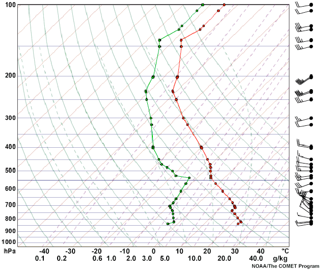
Question 3 of 3
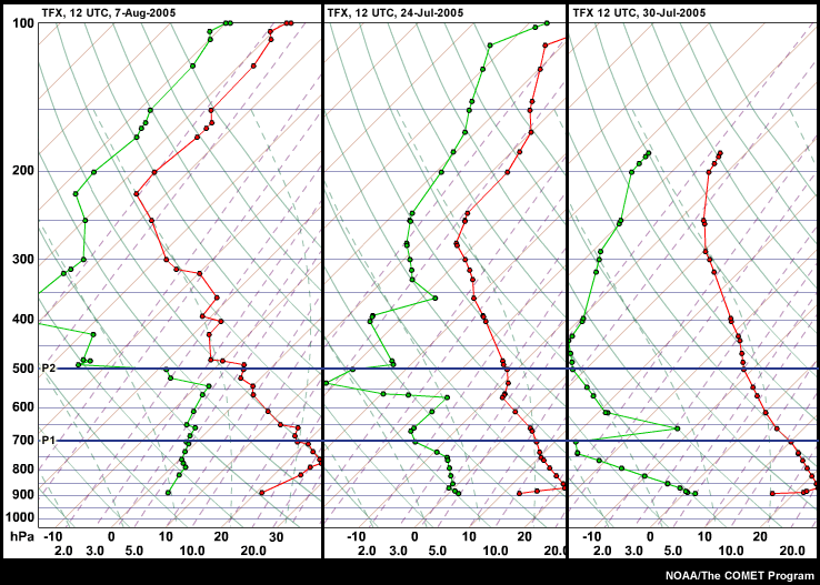
One of the three soundings from Great Falls, MT (elevation 1131 m or
3711
ft) above has a Haines Index of 6, while the
other two soundings have Haines Indices of 5. Which one is the six?
(Choose the best answer from the dropdown box, then click
Done.)
At first glance, all of the soundings have a similar pattern
with a surface based inversion and drier air above. However, the
7-Aug-2005 sounding (left) is more moist at 700 hPa, and the
24-Jul-2005 sounding (center) has an elevated stable layer near
550 hPa. These conditions resulted in HI values of 5 on both
these days.
In contrast, the 30-Jul-2005 sounding (right) has very dry
conditions at 700 hPa and a lapse rate high enough to support a
Haines Index of 6.
Congratulations, you have completed the "Fives & Six" section of
the Haines Game.
Haines Literacy
Congratulation on surviving the Haines Game to this point. Now comes the challenging part, reading Haines Index signatures in sounding data. To complete this level, you must answer all eight questions. Good Luck!
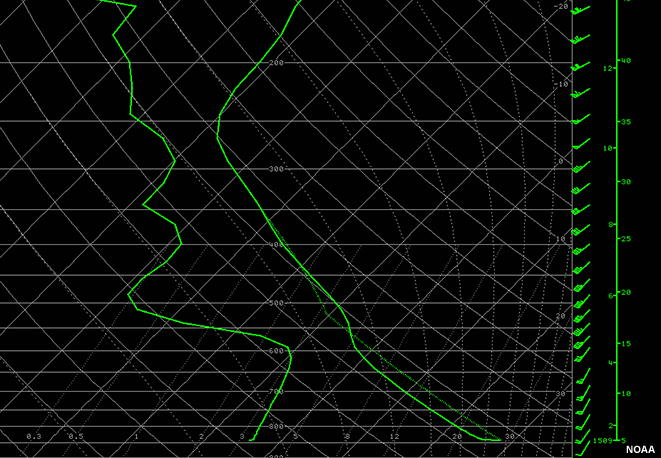
Question 1 of 8
The sounding shown from Spokane, WA (OTX), elevation of 728 m or 2388 ft,
has a Haines Index of 6. What features of this sounding should stand out
to you?
(Choose all that apply, then click Done.)
The correct answers are a, c and f.
The mid-elevation Haines Index is used for Spokane, WA. The Haines Index of 6 on this day resulted both from very dry air at 850 hPa and the nearly dry adiabatic lapse rate between 850 and 700 hPa. The inversion above 700 hPa is not of concern for a mid-level Haines site but may indicate the maximum level a plume could reach.
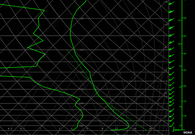
Question 2 of 8
The sounding shown from Rapid City, SD, elevation of 1029 m or 3375
ft,
has a Haines Index of 4. Why?
(Choose the best answer, then click Done.)
The correct answer is a) The low to mid-level lapse rates are steep, but there is too much moisture aloft to support development of large convective plumes.
Because the elevation of Rapid City, SD is 1029 m or 3356 ft, the high elevation Haines Index is used. In this example, the atmosphere is nearly dry adiabatic from above the surface inversion to 550 hPa. However, the mid-levels of the atmosphere are sufficiently moist to limit the Haines Index to a value of 4. Getting used to approximating dewpoint depressions to B term values is a valuable skill. The air at 700 hPa in this sounding is roughly at 45% relative humidity and would not be supportive of extreme fire behavior.
Question 3 of 8
The sounding shown from Rapid City, SD, elevation of 1029 m or 3375
ft,
has a Haines Index of 4. Why?
(Choose the best answer, then click Done.)
The correct answer is b) 700 hPa air is sufficiently dry, but 700-500 hPa lapse rates are not steep enough to support convection.
Because the elevation of Rapid City, SD is 1029 m or 3356 ft, the high elevation Haines Index is used. In this example, the atmosphere is very dry at 700 hPa. However, the absolutely stable lapse rate between 750 and 600 hPa limits the Haines Index to a value of 4.
Question 4 of 8
The sounding shown from Great Falls, MT, elevation of 1131 m or 3710
ft,
has a Haines Index of 4. Why?
(Choose the best answer, then click Done.)
The correct answer is c) Both the moisture term and the stability term are in the moderate range.
Because the elevation of Great Falls, MT is 1131 m or 3710 ft,
the high elevation Haines Index is used.
On this day, the stable air, which extended from 850 to 725 hPa
limited the value of the stability term. Also, the air at 700
hPa was not dry enough to yield a very high moisture term.
Consequently, the Haines Index was limited to 4 on this day.
It is important, when analyzing soundings, to consider the
elevation of the fire as opposed to the upper air site
elevation. In this example, the low level strong and moist
inversion would have prevented extreme fire activity at lower
elevations. But, a fire at a 6000-ft elevation likely would have
been active and possibly subjected to the upper airmass mixing
down.
Question 5 of 8
The sounding shown from Rapid City, SD, elevation of 1029 m or 3375
ft, at 00 UTC
has a Haines Index of 6. Despite this value, seasoned fire weather
forecasters do not expect formation of large convective plumes in the
fire zone. Why not?
(Choose the best answer, then click Done.)
The correct answer is d) The strong surface easterlies indicate a surface layer, which is very strongly capped at 00 UTC, and likely to resist mix-out for as long as that shallow surface layer continues its influx.
Because the elevation of Rapid City, SD is 1029 m or 3356 ft,
the high elevation Haines Index is used.
Note that this sounding was taken at 00 UTC, and therefore
represents the afternoon atmosphere in which all expected mixing
has taken place. In this sounding, the atmosphere is represented
as having a strongly decoupled surface layer as depicted by the
elevated inversion near 780-730 hPa, and the distinct difference
in wind direction below and above the inversion. Thus, the
Haines Index will not mix to the ground in this scenario and
rapid fire growth is not expected.
Question 6 of 8
The 00 UTC sounding shown from Rapid City, SD, elevation of 1029 m or
3375
ft, has a Haines Index of 5. How representative is that value, 5, of the
atmospheric profile indicated by the sounding?
(Choose the best answer, then click Done.)
The correct answer is b) A Haines Index of five could be misleading for people who do not examine the sounding because the 700 hPa T - Td difference is much greater that that for all levels above 600 hPa.
Because the elevation of Rapid City, SD is 1029 m or 3356 ft,
the high elevation Haines Index is used.
Although the 700 hPa level is sufficiently dry to support a
moisture term of 3, the air above steadily becomes more moist up
to 550 hPa and remains relatively moist above that level. This
example shows how calculating the moisture term at one level may
not best represent the state of the atmosphere.
There is even drier air beneath the sampling layer of 700 hPa,
which pushes the sounding to nearly a 6. Given such a sounding,
the forecaster should be sure to discuss expected changes as the
day progresses and deeper mixing occurs. The briefing statement
for fire bosses should include something like the following:
"Dramatically drier air will impact the fire when the inversion
breaks in the early afternoon. But the airmass aloft moistens
with height so conditions are expected to moderate later in the
afternoon."
Question 7 of 8
The sounding shown from Tampa Bay, FL, elevation of 15 m or
49
ft, has a Haines Index of 3. How representative is that value, 3, of the
atmospheric profile indicated by the sounding?
(Choose the best answer, then click Done.)
The correct answer is b) A Haines Index of three could be misleading for people who do not examine the sounding because the subsidence inversion is above the layer in which the Haines Index was calculated, and therefore the HI of 3 does not take into account the very dry air just above the 850 hPa level.
Because the elevation of Tampa Bay, FL is 15 m or 49 ft,
the low elevation Haines Index is used. However, this sounding
shows that the low-elevation HI does not represent the Tampa Bay
atmosphere in this case. The low-elevation HI does not reach
above the relatively deep mixed layer into the dry mid-level air
above it. Therefore the HI value, 3, could be misleading if
accepted without analysis of the sounding.
This sounding illustrates the importance of remembering that
applicable Haines levels vary by location. At first glance, this
sounding resembles one with a Haines 4 profile, due to dry air
aloft. But such an impression is misleading because of the
surface elevation is so much lower in Florida.
Question 8 of 8
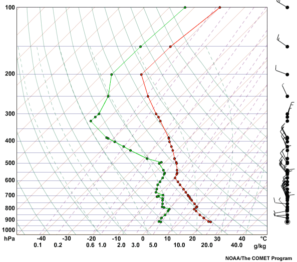
The sounding shown has a Haines Index of 6. Despite this value, seasoned
fire weather forecasters do not expect the formation of convective
plumes in the fire zone. Why not?
(Choose all that apply, then click Done.)
The correct answers are a, b and d.
This sounding illustrates the important point that the Haines Index does not represent all locations as well as those used to develop the index. The graphic of Haines Index climatology indicates that greater than 30% of 00 UTC soundings have HI=6 in June over northwestern New Mexico. Often the mixed layer extends into the layer used to calculate HI, which causes an artificially high stability term. It is important to understand how well the Haines Index represents conditions in your forecast area so that you can bet represent the HI to you customers.
Congratulations!
You answered all the questions, Well done!
Smoke Management
Overview
Significance
Ventilation Index
Heights & Winds
NWS
Interactive Weather Safety Planner
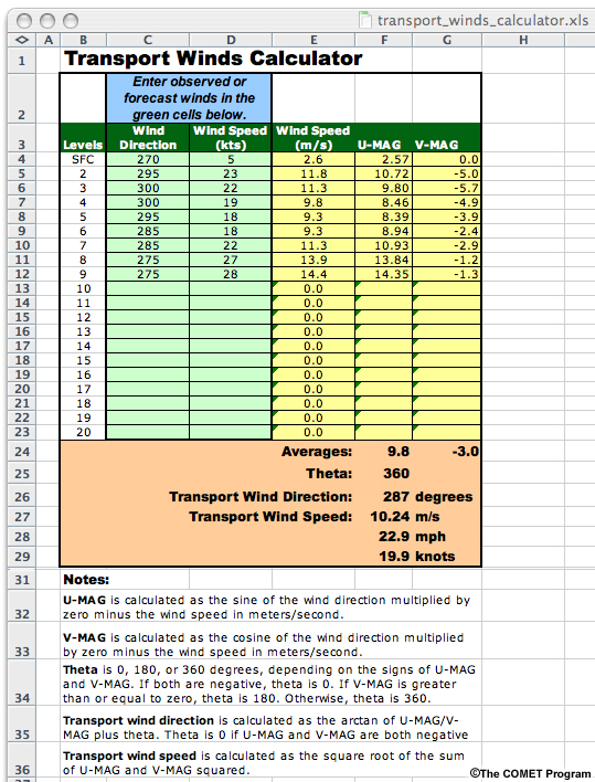
Click here to open the transport winds
calculator (Microsoft Excel Format).
Try using the transport winds calculator tool to estimate transport winds for the
following data set.
What are the estimated transport winds for this data set?
(Choose the best answer.)
The correct answer is d) 23 mph @ 287 degrees
Your transport winds calculator should look like the one
shown here.
Scenario 1
Day 1
Situation
Smoke Management Scenario 1
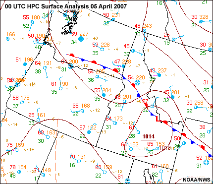
This scenario is based on actual events that occurred April 5-7, 2007, near Idaho City, ID.
Day 1: 5-April-2007
A well-coordinated prescribed burn was planned by local district fire managers. The forecaster believed that high pressure building aloft would be accompanied by a thermally-induced surface pressure "trough". As a result, locally-enhanced convective heating would generate enough instability and surface convergence over the steep terrain to produce lift and sufficient smoke ventilation.
For several days leading up to the burn, the forecast products continued to depict this scenario. Ventilation index values were forecast above 500 or in the "good" category, which was the low threshold documented in the forest's burn plan or "prescription". The fire managers had their seasonal employees trained and in place to ignite and monitor the operation. Also, hired support aircraft were at the ready.
View the data products, then click the Spot Forecast tab to continue.
Data

Spot Forecast
This is the final spot forecast issued by the local WFO on the day the burn was scheduled.
Review this forecast then click the Decision tab to continue.
...WARMING TREND INTO THE WEEKEND...
.DISCUSSION...
HIGH PRESSURE WILL BUILD OVER THE REGION THROUGH SATURDAY. THIS WILL BRING
WARMING TEMPERATURES TO ALL AREAS. WINDS OVER THE REGION ARE EXPECTED TO
REMAIN LIGHT. AS THE RIDGE BUILDS INTO THE AREA
TEMPERATURES ALOFT ARE ALSO GOING TO WARM WHICH MAY INHIBIT MIXING
HEIGHTS TODAY. MIXING HEIGHTS FOR FRIDAY ARE EXPECTED TO IMPROVE WHICH
WOULD HELP TAP INTO A LITTLE STRONGER WINDS...THUS BETTER
VENTILATION.
.TODAY...
SKY/WEATHER.........SUNNY.
MAX TEMPERATURE.....60 TO 65.
MIN HUMIDITY........25 TO 30 PERCENT.
WIND - EYE LEVEL....LIGHT UPSLOPE 2 TO 4 MPH THIS MORNING BECOMING UP
DRAINAGE 4 TO 6 MPH THIS AFTERNOON.
MIXING HEIGHT......5000 FT AGL.
TRANSPORT WIND.....NORTHWEST 5 TO 10 MPH.
VENTLIATION INDEX...400 FAIR.
NOAA
Decision
Judging from what you've seen, what do you think the fire boss for this
prescribed burn decided to do?
(Choose the best answer then click Done.)
The correct answer is b) Postponed the prescribed burn to the following day.
Fire Boss Decision: Postponed the prescribed burn to the following day. The ventilation index of 400 given in the spot forecast was below prescription. Because of this and the discussion indicating better conditions the following day, the burn boss decided to postpone the burn until the next day, Friday April 6th.
Click the Result tab to see what happened.
Result
What happened on April 5th?
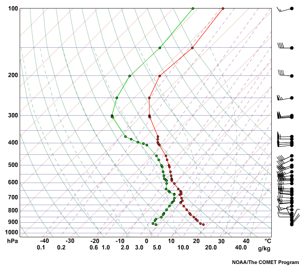
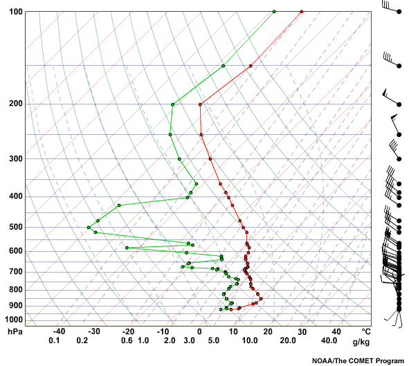
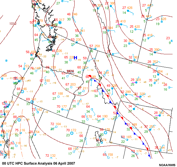
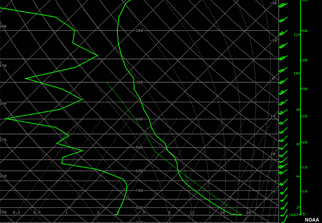
Examine the KBOI sounding from 6-Apr-07, 00 UTC. Note the dry adiabatic conditions
beneath a weak isothermal layer/cap near 10,000 feet. This cap is well above the
prescribed burn site elevations of 5200 to 6500 feet. Based on this profile, the
mixing height appears to be around 800 hPa, which is still above the elevation of
the burn site (5200 ft). Transport winds were northwest at 5 kts.
The data reveals that the spot weather forecast was a bit too optimistic with respect to ventilation index parameters, so it was a good call to postpone the burn until the following afternoon.
Continue onto the next page to explore Day 2.
Day 2
Situation
Day 2: 6-Apr-2007
After canceling the prescribed burn operation on April 5th, the fire boss
hoped there would be no further delays. Already, a considerable amount of
expense had been incurred bringing crews in, scheduling air support, and
waiting for the weather to cooperate.
Click the Data tab to continue.
Data
Spot Forecast
Recall from the spot forecast issued on the 5th that Friday the 6th was expected to have "better" ventilation due to higher mixing heights. Here is an updated spot weather forecast that was issued the morning of the 6th.
Review this forecast then click the Decision tab to continue.
...WARM AND DRY WITH LIGHT WINDS...
.DISCUSSION...
HIGH PRESSURE AT THE SURFACE AND ALOFT WILL ALLOW AIRMASS TO REMAIN DRY AND
STABLE. ONLY A FEW CLOUDS ARE EXPECTED WITH LIGHT UPSLOPE WINDS. INVERSION WILL BEGIN TO BREAK BY IGNITION TIME OF
1200 NOON ALLOWING MIXING UP TO 4000 FEET AGL. LATE AFTERNOON MIXING
WILL BE FURTHER ENHANCED WITH TEMPERATURES WARMING INTO THE LOWER
70S.
.REST OF TODAY...
SKY/WEATHER.........SUNNY.
MAX TEMPERATURE.....60 TO 65.
MIN HUMIDITY........22 TO 26 PERCENT.
WIND - EYE LEVEL....UPSLOPE WEST 3 TO 5 MPH.
MIXING HEIGHT......3500 TO 4000 FT AGL.
TRANSPORT WIND.....SOUTHWEST AROUND 5 MPH.
VENTLIATION INDEX...200 FAIR.
NOAA
Decision
Judging from what you've seen, what do you think the fire boss for this
prescribed burn decided to do?
(Choose the best answer then click Done.)
The correct answer is a) Went ahead with the prescribed burn on April 6th.
Fire Boss Decision: Went ahead with the prescribed burn on April 6th. This spot forecast indicated a "fair" ventilation index with a value of only 200. Although this was below burn plan thresholds, the forecast discussion specified that mixing would improve during the afternoon. This caused some confusion among the burn team, but after calling the forecaster and discussing the situation, the burn boss gained enough confidence to proceed with the project.
Click the Result tab to see what happened.
Result
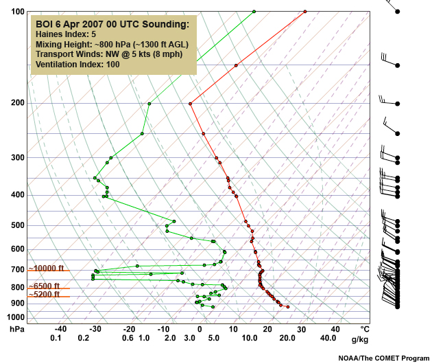
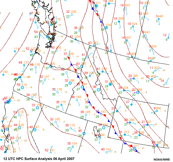
What happened on April 6th?
The afternoon upper air sounding above from KBOI on the 6th (00 UTC 7 April)
indicates that building high pressure aloft caused the isothermal layer or "cap" to
lower as a subsidence inversion. This stable layer aloft acted like a lid to close
off the Northerly wind flow above it and trap smoke below it. Feedback from the burn
boss indicated that winds on the fire were favorable in terms of ventilation and
mixing. This is consistent with observations from a nearby RAWS station with gusts
of 15 kts that afternoon. However, the densely populated valley below the burn site
had calm winds.
The prescribed burn accomplished the objectives in the burn plan, but the smoke drained into the canyons and settled right into the densely populated city which triggered an air stagnation advisory by the state regulatory agency. This resulted in stiff fines for the fire managers and negative press for the fire weather forecasters.
This case reinforces the need for fire managers and fire weather meteorologists to examine the big picture and remember that smoke from the fire is not limited to the burn area. Although the spot forecast issued on the 5th was right on the money in terms of identifying when the conditions would be within prescription constraints, smoke impacted an urban center removed from the prescribed area.
In this case, the spot forecasts did not take drainage flows into account, resulting in negative impacts for both the fire manager and the forecast office.
You have finished this scenario.
Continue onto the next page to explore Scenario 2.
Scenario 2
Situation 1
Smoke Management Scenario 2
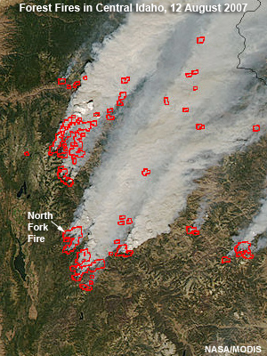
This scenario is based on actual events that occurred on August 12, 2007 on the
North Fork wildfire near Cascade, ID. At the time, numerous wildfires were burning
throughout the forested areas of central Idaho.
Morning: 12-Aug-2007
A wildfire is burning in a timbered forest near Cascade, ID. You are the IMET on the
fire, and the air attack/air operations chief is under pressure to supply fire hoses
via helicopter to firefighters who are protecting about a dozen historic mountain
cabins. Helicopters can fly any time after 0900 hours local time (1500 UTC),
depending on weather conditions.
Situation 2
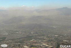
Strong nighttime radiation inversions have formed over the past 2 days and trapped dense smoke in the valleys and canyons. Yesterday, the inversion didn't lift until 1430 local time (2030 UTC).
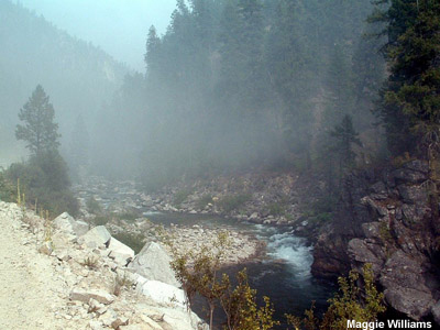
Johnson Creek near Yellowpine, ID 2030 UTC / 230 pm 11 Aug 2007.
Smokey skies hindered air operations.
Situation 3
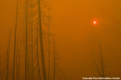
Helicopters can't fly under the current conditions. If the smoke persists, aviation assets may be reassigned to another incident. As an alternative, pack trains of mules could be arranged through a local outfitter to deliver the equipment and supplies to the firefighters. However, this option could introduce more risk of injury to personnel on the ground.
Fire aviation managers are getting anxious for a window of time for their aircraft to fly. Not only do the firefighters need equipment, but the Boise National Forest pays a hefty price to keep the aircraft and the pilot in "stanby mode".
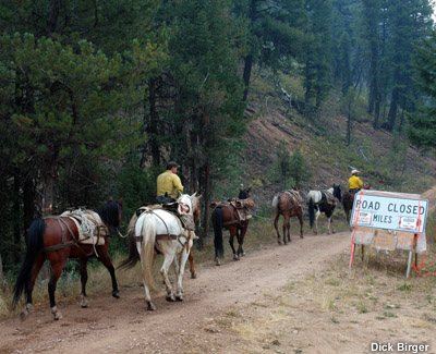
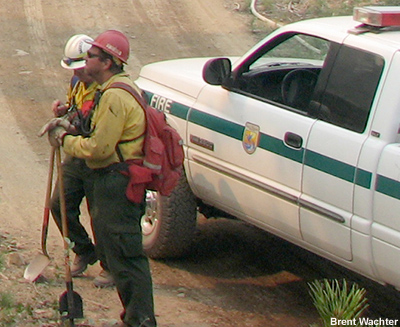
Mule pack train with emergency firefighting equipment, Payette National Forest
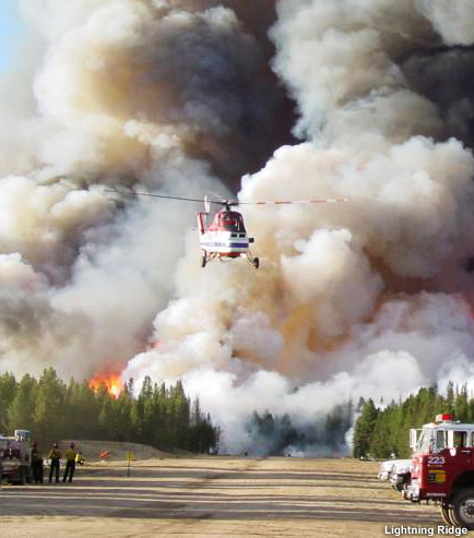
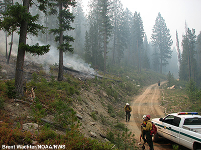
Burnout operations at Landmark, ID
Click the Data tab to continue.
Data 1
Synoptic Setup
For the last 2 days high pressure aloft has intensified over Colorado while a strong
trough moved toward the Pacific Northwest Coast. A thermally induced surface
pressure trough led to a weak pressure gradient and light winds, stregthening the
nighttime radition inversion.
A strong upper level jet streak is forecast to cross through the area from the Southwest with stronger winds forecast near ridgetop (6600 to 7000 ft or near 800 hPa).
Data 2
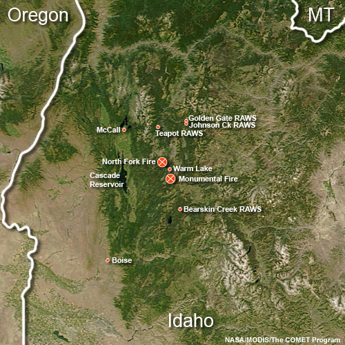
Observed Sounding, Boise, ID
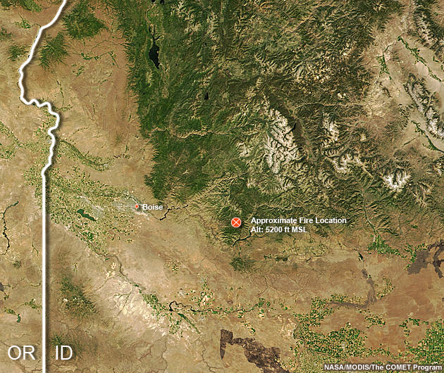
The sounding from Boise is 70 miles southwest of the fire. In the fire area, valleys
are near 5200 ft in elevation or near 850 hPa. Midslope is between 5800 and 6200 ft
or about 825 hPa. Ridgetop level in the area from 6600 to 7000 ft ot about 800 hPa.
From the 1200 UTC BOI sounding, winds of 20 kts were observed between 850 to 800 hPa.
Data 3
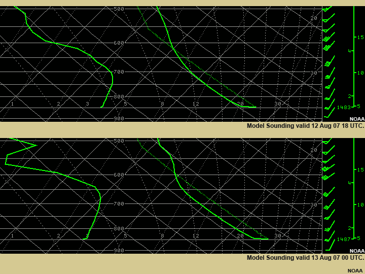
Model Soundings
Model soundings indicate that winds between 600-700 hPa will increase to 35 to 40
kts over the next 6 hours. These winds could mix down and accelerate through
elevated passes and channel through major river drainages. Keep in mind that even
though ridges are 6600 to 7000 ft (or about 800 hPa), many of the peaks extend to
9000 ft or more.
If winds do increase, this situation will provide enough mixing to scour out the smoky inversion, allowing better visibility for the helicopter pilots to fly. On the other hand, if winds exceed 35 kts, the aircraft will remain grounded for safety reasons, costing thousands of dollars of lost flight time. You need to determine whether winds will be sufficient to mix out the smoke, and whether they will remain within criteria for safe aircraft operations.

Data 4
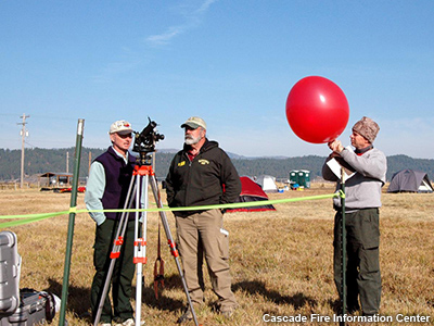
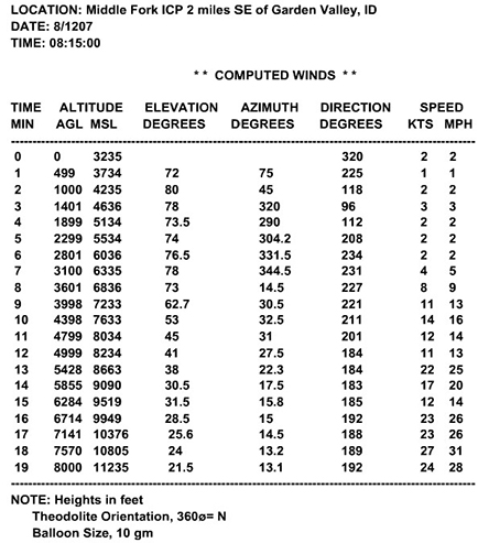
Local PIBAL
Conditions were too smoky to release a sounding at the fire. An experienced IMET
assigned to a nearby fire was able to track a PIBEL at 0815 local time (1415 UTC)
with the following results. Notice that the winds increased above 10 kts near
ridgetop (6600 to 7000 ft), and 13 minutes into the flight, winds were over 20 kts.
If these conditions are truly representative of you fire location, then the
inversion should begin lifting within a few hours and the smoke should clear.
Click the Smoke Management tab to continue.
Smoke Management 1
What are the forecast mixing heights at 18 UTC and 00
UTC?
Type a value in each box.
The mixing height at 18 UTC is forecast to be 10,000 ft or approximately 620 hPa, and increase to ~13,000 ft or near 600 hPa at 00 UTC (1800 LT).
Smoke Management 2

At 0000 UTC, the transport winds are near 210
degrees at 26 kts the resulting ventilation index is 13,000 ft x 26
kts = 33,800. The index is then calculated by dividing this value by
100, which gives a ventilation index of 338 which corresponds to a
category of excellent. Winds near the top of the mixed layer are
above the 35 kt level that could ground aircraft, however the
transport winds are expected to remain below 35 kts, and helicopters
should be able to fly.
Adjective ratings for ventilation index used in this area are:
< 200 Poor
200 < 500 Fair
500 < 700 Good
700 + Excellent
Result 1
Spot Forecast
This was the spot forecast issued on that day.
The forecast called for winds to increase, but remain below the criteria to ground helicopters. The forecast strong winds and deep mixed layer resulted in a ventilation forecast to be excellent.
...RED FLAG WARNING IN EFFECT FROM NOON MDT TODAY THROUGH THIS EVENING FOR GUSTY WINDS...
.DISCUSSION...
AFTER THE INVERSION BREAKS AROUND
NOON... LOW LEVELS IN THE ATMOSPHERE WILL BECOME VERY DRY. THE
BIGGEST THREAT WILL BE GUSTY WINDS TO 30
MPH WITH A JET STREAK THAT WILL MIX DOWN TO RIDGE LEVEL. IN
ADDITION...HUMIDITIES WILL BOTTOM OUT IN THE SINGLE DIGITS. COOLER WEATHER
WITH HIGHER HUMIDITIES WILL COME IN NEXT WEEKEND AS AN UPPER TROUGH OFF THE
NW COAST COMES CLOSER.
.TODAY...
SKY/WEATHER.........SMOKEY THIS MORNING UNTIL
INVERSION BREAKUP AROUND 1130. BECOMING SUNNY.
MAX TEMPERATURE.....88 TO 93.
MIN HUMIDITY........6 TO 10 PERCENT.
WIND - EYE LEVEL....SOUTHWEST 8 TO 10 MPH WITH
GUSTS TO 30 MPH IN THE AFTERNOON.
HAINES INDEX.........6 HIGH.
MIXING HEIGHT......14500 FT AGL.
TRANSPORT WIND.....
SOUTHWEST AROUND 25 MPH
.
VENTLIATION INDEX...725 EXCELLENT.
NOAA
Result 2
What Happened?
Weather observations from Johnson Creek Fire RAWS station (at an elevation of 4925
ft in a tight drainage South of Yellowpine, Idaho) revealed a significant hourly
change in weather conditions, indicative of the inversion break-up that occurred
between 1100 to 1200 local time (1700 and 1800 UTC). During this hour, wind gust
strengthened from 8 to 21 kts. Relative humidity fell from 32% to 12% while
temperature increased 12°F in one hour.
Field observers reported that fire behavior associated with this rapid weather change intensified exponentially within a span of about 10 minutes. Single-tree torching transitioned to group torching only briefly before entire stands of timber were consumed.
Field observers and satellite pictures indicated a distinct band of Altocumulus Castellanus (ACCAS) after 1200 Local (1800 UTC) coincident with the time that the model was forecasting enhanced vertical motion associated with a weak short wave trough. This instability allowed the inversion to break up. Satellite imagery shows the smoke in the valleys mixes out as the inversion breaks, resulting in improved visibility.
Johnson Creek RAWS NOAA
| Local Time | Temp | RH% | Wind | Gust |
|---|---|---|---|---|
| 1100 | 71 | 32 | 0.0 | 3.0 |
| 1200 | 83 | 12 | 3.0 | 8.0 |
| 1300 | 83 | 9 | 6.0 | 21.0 |
Result 3
Operations
Wind speeds remained below 30 kts, allowing fire managers to meet their objectives
safely and bring the needed equipment to the fire fighting crews.
This scenario illustrated a situation where stronger winds were needed to mix smoke out of the valley before air operations could begin. However, had winds increased too much, air resources would have been grounded due to high winds.
As a forecaster, you need to be aware of how the weather affects your customers and their criteria for safe operations.
Contributors
COMET Sponsors
The COMET® Program is sponsored by NOAA National Weather Service (NWS), with additional funding by:
- Air Force Weather Agency (AFWA)
- Australian Bureau of Meteorology (BoM)
- Meteorological Service of Canada (MSC)
- National Environmental Education Foundation (NEEF)
- National Polar-orbiting Operational Environmental Satellite System (NPOESS)
- NOAA National Environmental Satellite, Data and Information Service (NESDIS)
- Naval Meteorology and Oceanography Command (NMOC)
Principal Science Advisor
- Dan Borsum — NWS
- Coleen Decker — NWS
Project Lead
- Dr. Elizabeth Mulvihill Page — UCAR/COMET
Instructional Design
- Dwight Owens — Alphapure Design Studio
Computer Graphics/Interface Design
- Steve Deyo — UCAR/COMET
- Brannan McGill — UCAR/COMET
Multimedia Authoring
- Dan Riter — UCAR/COMET
Audio Editing/Production
- Seth Lamos — UCAR/COMET
Audio Narration
- Hildy Kane — UCAR/COMET
COMET HTML Integration Team 2020
- Tim Alberta — Project Manager
- Dolores Kiessling — Project Lead
- Steve Deyo — Graphic Artist
- Gary Pacheco — Lead Web Developer
- Justin Richling — Associate Scientist
- David Russi — Translations
- Gretchen Throop Williams — Web Developer
- Tyler Winstead — Web Developer
COMET Staff, Spring 2008
Director
- Dr. Timothy Spangler
Deputy Director
- Dr. Joe Lamos
Administration
- Lorrie Alberta
- Michelle Harrison
- Hildy Kane
Graphics/Media Production
- Steve Deyo
- Seth Lamos
- Brannan McGill
Hardware/Software Support and Programming
- Tim Alberta (IT Manager)
- James Hamm
- Ken Kim
- Mark Mulholland
- Carl Whitehurst
- Malte Winkler
Instructional Design
- Patrick Parrish (Production Manager)
- Dr. Alan Bol
- Lon Goldstein
- Dr. Vickie Johnson
- Bruce Muller
- Dwight Owens (Alphapure Design Studio)
- Marianne Weingroff
Meteorologists
- Dr. Greg Byrd (Project Cluster Manager)
- Wendy Schreiber-Abshire, Senior Project Manager
- Dr. William Bua
- Patrick Dills
- Dr. Stephen Jascourt
- Matthew Kelsch
- Dolores Kiessling
- Dr. Arlene Laing
- Dr. Elizabeth Mulvihill Page
- Warren Rodie
- Amy Stevermer
- Dr. Doug Wesley
Science Writer
- Jennifer Frazer
Spanish Translations
- David Russi
NOAA/National Weather Service — Forecast Decision Training Branch
- Anthony Mostek (Branch Chief)
- Dr. Richard Koehler (Hydrology Training Lead)
- Brian Motta (IFPS Training)
- Dr. Robert Rozumalski (SOO Science and Training Resource [SOO/STRC] Coordinator)
- Ross Van Til (Meteorologist)
- Shannon White (AWIPS Training)
Meteorological Service of Canada Visiting Meteorologists
- Phil Chadwick
- James Cummine