Gulf of Mexico — Climatology
Table of Contents
Jet Streams
Jet Streams Polar Jet
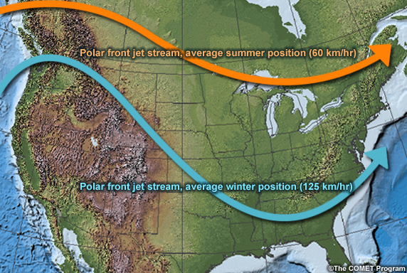
The Polar Jet affects the Gulf of Mexico mainly during winter when it normally reaches its southernmost position. Incursions of the polar jet into the Gulf are most common when the jet pattern is meridional, which allows cold, polar air to move equatorward into the Gulf. Storms moving along the jet are the source of clouds and precipitation in the Gulf, particularly when there is confluence of the polar and subtropical jet streams.
Jet Streams Subtropical Jet
The subtropical jet migrates from the tropical and subtropical latitudes during winter, when it is strongest and nearly continuous, to the midlatitudes during summer, when it is weakest and intermittent.
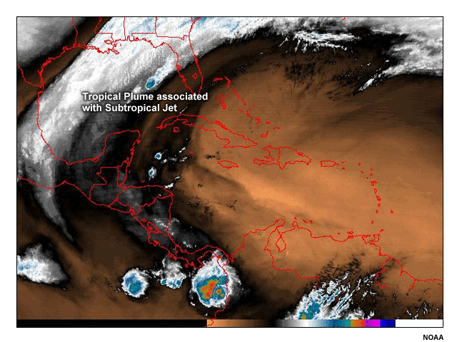
It is usually noticeable as a plume of tropical moisture in satellite water vapor imagery. Confluence with the polar jet over the U.S. Gulf Coast and Mexico enhances cyclogenesis.
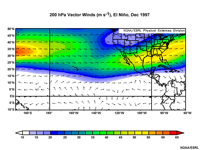
The subtropical jet has its strongest impact on the Gulf of Mexico during El Ni�o winters when the tropical eastern Pacific Ocean is anomalously warm. A persistent and stronger than normal subtropical jet brings cooler and wetter conditions to the Gulf.
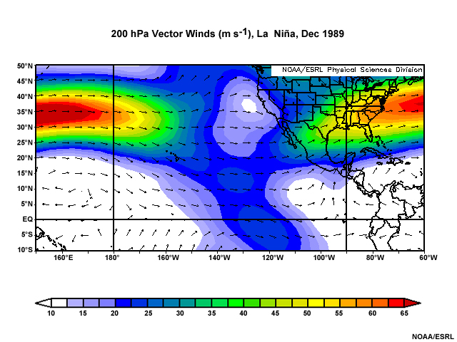
During cold ENSO phase or La Ni�a winters, it is drier than normal, as the subtropical Pacific Jet splits and the branch that flows over the Gulf of Mexico is weaker.
Synoptic Patterns
Synoptic Patterns Bermuda-Azores High
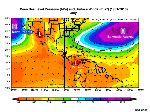
A ridge that extends from the Bermuda-Azores High is the dominant large-scale feature over the Gulf of Mexico during summer when summer southeasterly winds replace the winter northeasterlies. The strength and position of the ridge influence where hurricanes will make landfall along the Gulf Coast and Mexico.
During La Niña summers, a high-pressure center forms over the Gulf and the mean flow becomes northerly and northwesterly over Florida and the eastern Gulf. Instead of moist, maritime air, the eastern Gulf has drier continental air, which raises the potential for wildfires over Florida and other southeastern states, as occurred during the record-breaking outbreaks of May-June 1998 and 2001.
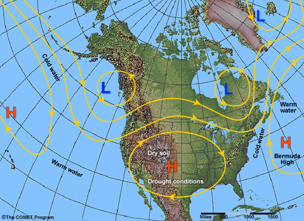
Synoptic Patterns North American High
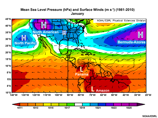
The North American High, a shallow area of high pressure, is the prevailing circulation over the northern Gulf during winter. Northerly to easterly winds flow around a broad, weak ridge that extends from the continental high to the western Gulf. The high moves south during cold outbreaks and brings strong northerly winds (northers) into the Gulf of Mexico. These cold outbreaks usually happen in the wake of a strong cold front and where upper-level convergence strengthens the surface high pressure. The high retreats north during spring and summer as the surface warms and the ridge from Bermuda-Azores High shifts westward. High pressure is reestablished during autumn and gets stronger as surface temperatures fall further during winter.
Synoptic Patterns North American Monsoon
The North American Monsoon (NAM) is centered on the Sonora or Mexican Low, the thermal low that forms over southwestern U.S. and northwestern Mexico and sometimes extends to the highlands of the Sierra Madre Occidental. Unlike the Asian monsoon, the NAM is not a true monsoon because there is no corresponding winter equivalent.
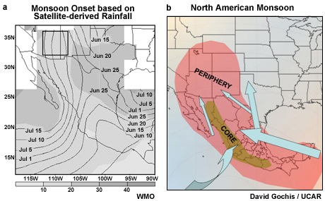
The westernmost Gulf of Mexico is the only part of our area that is affected by the NAM. The Sonora Low is most prevalent from mid-June until mid-September. It is rarely present before late May or after early October.
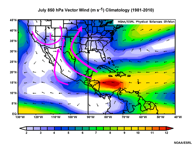
Air flows from the Gulf into the thermal low, mostly between 850 and 700 hPa. The lowest pressure is usually reached in June with a slight rise thereafter, as surface heating decreases with afternoon clouds and precipitation. The low has maximum vertical extent in July and early August when the cyclonic circulation reaches the 700-hPa level. Above that level is anticyclonic flow.
A broad high at 500 hPa extends from the tropical Atlantic westward across the Gulf and Caribbean Sea from late spring to early autumn. During June, the 500 hPa high moves over northern Mexico and the southwest U.S., which allows the thermal low to expand upwards. By mid-July, winds are light and variable over the southern U.S., Mexico, and the Gulf of Mexico, and mid-level westerlies are all north of 40N. The 500 hPa high and westerlies start shifting southward in August. After that the low at 700 hPa starts to breakdown but persists from the surface to 850 hPa through August and early September. The breakdown of the surface and 850 hPa low occurs in mid-to-late September.
Extratropical Cyclones
Extratropical Cyclones Polar Front
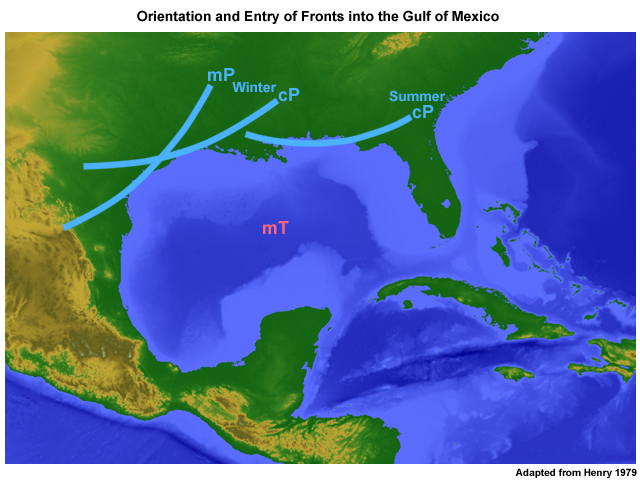
The polar front migrates from far north in Canada during summer to the Gulf Coast and Florida during winter. During winter (the dry season), fronts (and dissipating fronts) are important sources of precipitation and severe weather in the Gulf of Mexico.
Fronts enter the Gulf from the north (continental Polar or continental Arctic origin) or from the west (north Pacific, maritime Polar origin). Most of the fronts from the west are associated with cyclones moving from the Pacific across the Rockies and Sierras or cyclones that form in the lee of those mountains. While a front may enter the Gulf any month of the year, they are more frequent during winter. On average the passage of cold fronts and associated cold air outbreaks occur about 4-7 times per month during the cool season (November to February) and 0-2 times per month during the warm season.
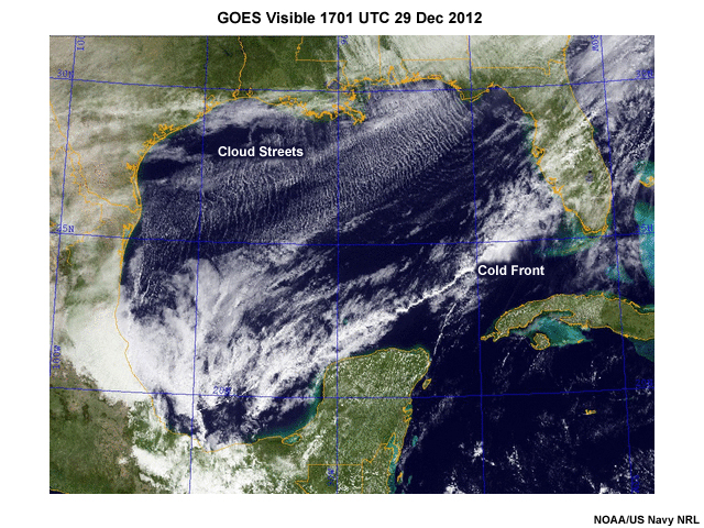
Cold air outbreaks over the Gulf of Mexico during winter result in widespread cloud streets in the boundary layer. These shallow clouds form as cold air flows over relatively warm water, which adds an influx of moisture and leads to condensation. In the image, the cloud streets occupy nearly the entire northern Gulf, while the cold front is evident as a band of bright clouds extending from south Florida to the southwestern Gulf. About 60% of winter fronts move south and east from the Gulf into the Caribbean. On rare occasions, fronts shift back into the Gulf, even becoming warm fronts. Fronts also push south across Mexico into the Pacific in the vicinity of the Gulf of Tehuantepec, bringing strong northerly winds.
Extratropical Cyclones Midlatitude Cyclones
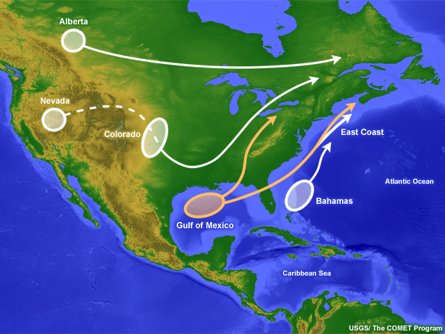
Cyclones generally form in the western or eastern Gulf. Then, they move either along the Gulf Coast and northeast along the Atlantic Coast (east of the Appalachians), or from the Gulf Coast inland, along the Mississippi and Ohio River Valleys (west of the Appalachians).
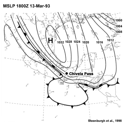
Western Gulf lows usually form from remnant fronts of cyclones whose centers are farther north. The surface charts show an example of a low that formed along a front over the western Gulf of Mexico.
The corresponding satellite infrared images show the transformation of the frontal band into the typical comma-shaped cloud pattern of a midlatitude cyclone. Notice the circulation around the low pressure center in the northern Gulf coast.
Gulf lows are usually more intense than lows that form inland because of:
- Strong thermal contrast between the warm ocean and cold land, which enhances baroclinic instability
- Latent heat release during condensation of large amounts of warm moist air from the Gulf of Mexico and the Gulf Stream, which helps to intensify the cyclone
- Sensible heat release from the warm Gulf surface
- The presence of jet streaks, which helps to create regions of upper-level divergence in a region of confluence between the polar jet and the subtropical jet
Gulf cyclones are especially dangerous because they transport copious moisture into the midlatitudes, which can lead to heavy snowfall across the eastern states.
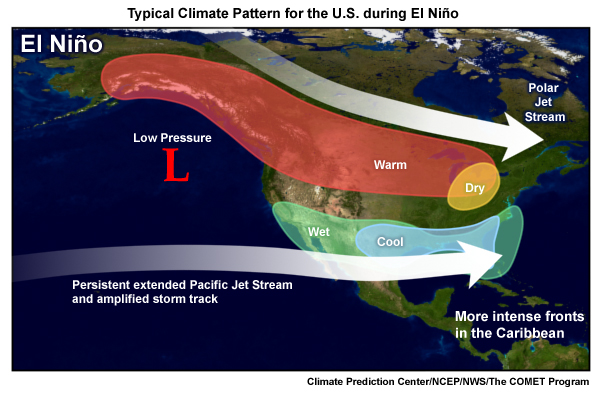
The number of midlatitude cyclones in the Gulf of Mexico increases during El Ni�o winters because of the persistence of the subtropical jet and the presence of mean cyclonic circulation at the upper levels over the Gulf. The opposite occurs with La Niña when the jet stream is anomalously weaker and fewer cyclones occur in the Gulf.
Extratropical Cyclones Tehuantepec Gap Winds
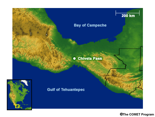
The Chivela Pass in the Isthmus of Tehuantepec in southern Mexico acts as a conduit for air to flow between the Gulf of Mexico and the Pacific Ocean. When strong northerly winds move south in the wake of cold fronts and polar surges over the Gulf of Mexico, they are channeled through the Chivela Pass. The air accelerates through the pass and emerges as gale-force or storm force winds in the Gulf of Tehuantepec on the Pacific coast, with gusts exceeding 50 m s-1 (100 kt) in extreme cases. The rapid movement of surface waters by these gap winds, known as “Tehuantepecers,” causes higher significant wave heights, an increase in the surface currents, strong coastal upwelling, and cooling of the SSTs over the Gulf of Tehuantepec.
Extratropical Cyclones » Tehuantepec Gap WindsSynoptic Conditions
One of the typical synoptic conditions for strong Tehuantepec gaps winds is a midlatitude cyclone with a cold front that extends into the southern Gulf. For example, on 28-30 December 2012, as a Gulf cyclone moved east, its associated cold front extended southwestward across the Gulf. Winds shifted from weak southerly and southeasterly winds on 28 December to strong northerly winds on 29 December, as high pressure expanded south along the western Gulf coast (east of the Sierra Madres) and the pressure gradient increased between the Gulf and the Pacific.
Extratropical Cyclones » Tehuantepec Gap WindsGap Winds and Significant Wave Height
As the northerly winds strengthened and accelerated through the Chivela Pass, they caused gales on the Pacific coast. On 30-31 December, wind speeds in the Gulf of Tehuantepec reached 25 m s-1 (50 kt) and significant wave heights exceeded 4.3 m (14 ft as shown on the 4th and 5th images). At the same time, in the southern Gulf of Mexico, significant wave height increased to over 2.4 m (8 ft) in the southern Gulf.
Extratropical Cyclones » Tehuantepec Gap WindsGap Winds and Sea Surface Temperature
The animations illustrate the cooling of SSTs in the Gulf of Tehuantepec as the winds shift from weak easterlies to accelerating northerlies between 29 and 30 December 2012. The surface cools as deeper water is upwelled to replace the surface water pushed away from the coast by the strong winds. Therefore, the coolest SSTs occur after the peak offshore winds.
Extratropical Cyclones » Tehuantepec Gap WindsGap Winds and Surface Currents
The animations illustrate the shift in surface current speed and direction in Gulf of Tehuantepec for the period 29 -31 December 2012. The peak offshore currents on 30 December coincide with the peak northerly winds.
Extratropical Cyclones » Tehuantepec Gap WindsRemote Sensing of Tehuantepec Events
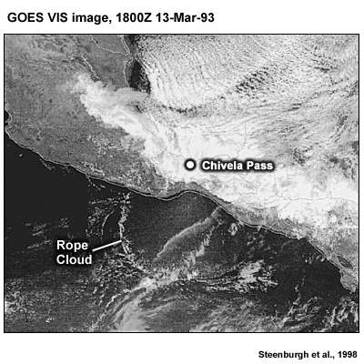
In addition to monitoring surface station observations and SSTs, Tehuantepec events can be identified using high-resolution visible satellite imagery. Notice the north-south oriented cloud streets over the Gulf of Mexico, due to cold northerly air flow over warm water. In the Gulf of Tehuantepec, rope clouds sometimes form along the spreading outflow boundary of the gap winds.
Microwave sensors on polar orbiting satellites detect the strong winds produced in the wake of the cold front and acceleration through the Chivela Pass.
Extratropical Cyclones » Tehuantepec Gap WindsClimatology
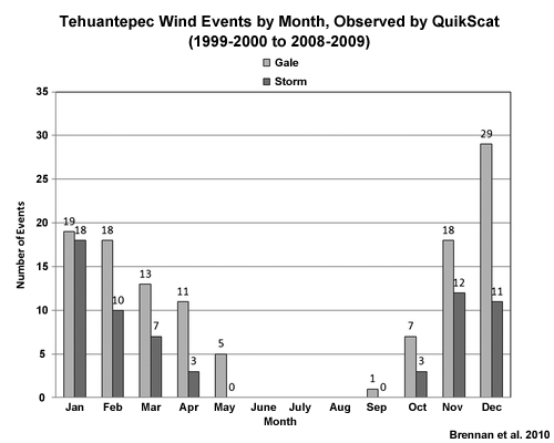
According to observations by the QuikScat satellite from the cool season of 1999-2000 to the cool season of 2008-2009, an average of about 12 gale-force and 6 storm-force events occurred during October to May. Most gale-force events occurred during December, while most storm-force winds occurred in January. The 2006-2007 cold season, which recorded the highest number of storm-force events, occurred during a weak El Niño. This finding is consistent with observations of more midlatitude cyclones, cold surges, and associated northerly winds due to a more prominent jet entrance region over the Gulf of Mexico.
Tropical Cyclones
Tropical Cyclones Seasonal Activity in the Gulf of Mexico
At the beginning of hurricane season, there is little or no tropical cyclone genesis in the Gulf of Mexico. Formation in this area tends to remain fairly low until about mid-June. Although there appears to be a lull in the middle of July, the number of tropical cyclones originating in the Gulf is relatively high and constant through the end of August and increases through most of September. Around the end of October, formation in the Gulf dies down dramatically, with none observed (at least through 2009) in this area after November 11.
Tropical Cyclones Intra-seasonal Variability
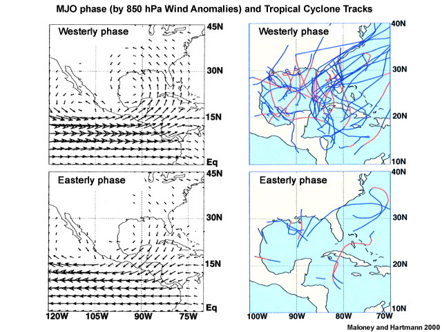
Intraseasonal tropical cyclone activity in the Gulf of Mexico is tied to phases of the MJO. More tropical cyclones occur during the convective phase of the MJO when anomalous westerly winds at 850 hPa bring moisture from the tropical Pacific into the Gulf and low-level cyclonic circulation is enhanced in the Gulf. In contrast, tropical cyclone activity is greatly diminished during the suppressed phase of the MJO when 850 hPa winds are easterly and high pressure prevails in the low troposphere.
Tropical Cyclones Interannual Variability
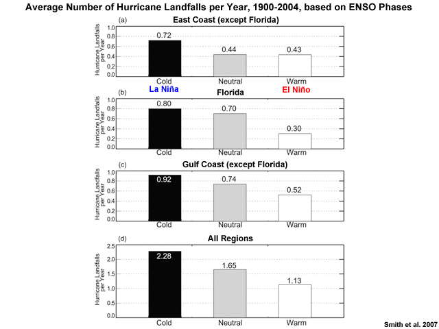
For the North Atlantic as a whole, it is well known that El Niño phases lead to reduced hurricane activity and La Niña phases lead to increased activity. However, for Florida and the rest of the U.S. Gulf Coast little change is observed for landfalls between La Niña and neutral years.
Questions
Questions Question 1
The number of tropical cyclones originating in the Gulf of Mexico peaks in: (Choose the best answer.)
The correct answer is c.
However, the last half of August and early October are also active genesis periods.
Questions Question 2
Use the selection box to choose the answer that best completes the statement.
Questions Question 3
Use the selection boxes to choose the answers that best completes the statement.
Questions Question 4
Choose the true statements about fronts in the Gulf of Mexico: (Choose all that apply.)
The correct answer are c, d, and e.
Fronts enter the Gulf from both the north and the west and can occur in any month although most occur during winter. Fronts in the Gulf form between maritime Tropical air masses and continental Polar or Arctic air masses as well as maritime Polar air masses. More than 60% of fronts move from the Gulf of Mexico into the Caribbean.
Questions Question 5
Use the selection box to choose the answer that best completes the statement.
Northerly winds are accelerated by flow through the Chivela Pass of the Isthmus of Tehuantepec.
Questions Question 6
Use the selection box to choose the answer that best completes the statement.
Questions Question 7
Use the selection boxes to choose the answers that best completes the statement.