| TIME 1 05 min. after EQ |
TIME 2 35 min. after EQ |
TIME 3 1 hr 05 min. after EQ |
TIME 4 ~ 3 hrs. after EQ |
TIME 5 ~ 48 hrs. after EQ |
NTWC/PTWC Message to WFOs:
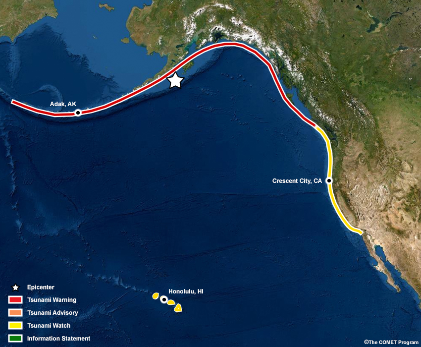
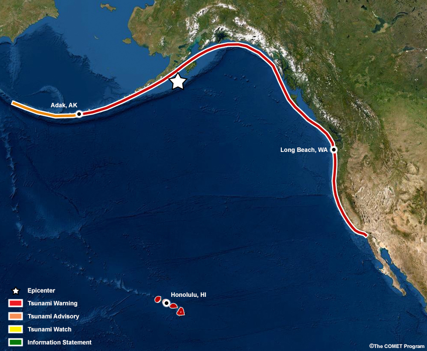
At 0830 am AKDT, an earthquake occurred offshore of the Alaska Peninsula, 100 miles southeast of Chignik, Alaska. A tsunami may have been generated and the TWCs issue an initial message within 5 minutes. In this case, a Tsunami Warning has been issued for the Alaska and Canada coastlines, with initial earthquake information and calls to action for getting people to safety. If a tsunami has been generated, the threat will be imminent and people in locations close to the source have no time to wait. For locations farther from the earthquake source, there is more time to respond as the TWCs evaluate the earthquake and potential tsunami threats and impacts. A Tsunami Watch has been issued for the U.S. West Coast and Hawaii.
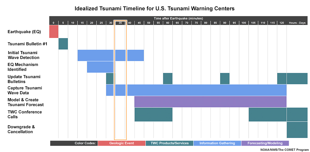
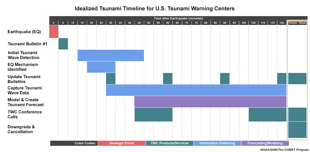
Timeline
Click on the graphic to see larger view.

Active Alerts
NTWC
    ...TEST Public Tsunami Message Number 1 ...TEST
    NWS National Tsunami Warning Center Palmer AK
    0835 AM AKDT Thu May 13 2022

    ...A TSUNAMI WARNING IS NOW IN EFFECT...


    ...A TSUNAMI WATCH IS NOW IN EFFECT...


    Tsunami Warning in Effect for;

     * BRITISH COLUMBIA, The north coast and Haida Gwaii and the
       central coast and northeast Vancouver Island

     * SOUTHEAST ALASKA, The inner and outer coast from The
       BC/Alaska Border to Cape Fairweather, Alaska (80 miles SE
       of Yakutat)

     * SOUTH ALASKA AND THE ALASKA PENINSULA, Pacific coasts from
       Cape Fairweather, Alaska (80 miles SE of Yakutat) to Unimak
       Pass, Alaska (80 miles NE of Unalaska)

     * ALEUTIAN ISLANDS, Unimak Pass, Alaska (80 miles NE of
       Unalaska) to Attu, Alaska including the Pribilof Islands


    Tsunami Watch in Effect for;

     * CALIFORNIA, The coast from The Cal./Mexico Border to The
       Oregon/Cal. Border including San Francisco Bay

     * OREGON, The coast from The Oregon/Cal. Border to The
       Oregon/Wash. Border including the Columbia River estuary
       coast

     * WASHINGTON, Outer coast from the Oregon/Washington border
       to Slip Point, Columbia River estuary coast, and the Juan
       de Fuca Strait coast

     * BRITISH COLUMBIA, The outer west coast of Vancouver Island
       and the Juan de Fuca strait coast

    TEST...TEST...TEST...TEST...TEST...TEST...TEST...TEST...TEST...TEST

    PRELIMINARY EARTHQUAKE PARAMETERS
    ---------------------------------

     * The following parameters are based on a rapid preliminary
       assessment of the earthquake and changes may occur.

     * Magnitude      8.2
     * Origin Time    0830 AKDT May 13 2022
                      0930  PDT May 13 2022
                      1630  UTC May 13 2022
     * Coordinates    55.2 North 156.7 West
     * Depth          11 miles
     * Location       100 miles SE of Chignik, Alaska
                      485 miles SW of Anchorage, Alaska

    TEST...TEST...TEST...TEST...TEST...TEST...TEST...TEST...TEST...TEST

    FORECASTS OF TSUNAMI ACTIVITY
    -----------------------------
     * Tsunami activity is forecasted to start at the following
       locations at the specified times.

                     FORECAST
                     START
    SITE             OF TSUNAMI
    ----             ----------

     * Alaska
    Sand Point       0930 AKDT May 13
    Kodiak           1000 AKDT May 13
    Unalaska         1005 AKDT May 13
    Elfin Cove       1025 AKDT May 13
    Seward           1025 AKDT May 13
    Cold Bay         1025 AKDT May 13
    Adak             1030 AKDT May 13
    Sitka            1035 AKDT May 13
    Yakutat          1035 AKDT May 13
    Valdez           1045 AKDT May 13
    Cordova          1055 AKDT May 13
    Shemya           1110 AKDT May 13
    Homer            1120 AKDT May 13
    Saint Paul       1125 AKDT May 13
    Craig            1135 AKDT May 13

     * British Columbia
    Langara          1145  PDT May 13
    Tofino           1310  PDT May 13

     * Washington
    La Push          1320  PDT May 13
    Neah Bay         1325  PDT May 13
    Long Beach       1330  PDT May 13
    Westport         1335  PDT May 13
    Moclips          1335  PDT May 13
    Port Angeles     1400  PDT May 13
    Port Townsend    1430  PDT May 13

     * Oregon
    Port Orford      1330  PDT May 13
    Charleston       1335  PDT May 13
    Newport          1340  PDT May 13
    Brookings        1340  PDT May 13
    Seaside          1340  PDT May 13

     * California
    Fort Bragg       1345  PDT May 13
    Crescent City    1345  PDT May 13
    Monterey         1415  PDT May 13
    San Francisco    1435  PDT May 13
    Port San Luis    1440  PDT May 13
    Santa Barbara    1455  PDT May 13
    Los Angeles Harb 1510  PDT May 13
    Newport Beach    1515  PDT May 13
    Oceanside        1520  PDT May 13
    La Jolla         1520  PDT May 13


    OBSERVATIONS OF TSUNAMI ACTIVITY
    --------------------------------
     * No tsunami observations are available to report.

    TEST...TEST...TEST...TEST...TEST...TEST...TEST...TEST...TEST...TEST

    RECOMMENDED ACTIONS
    -------------------
    Actions to protect human life and property will
    vary within tsunami warning areas.

    If you are in a tsunami warning area;

     * Evacuate inland or to higher ground above and beyond
       designated tsunami hazard zones or move to an upper floor
       of a multi-story building depending on your situation.

     * Move out of the water, off the beach, and away from
       harbors, marinas, breakwaters, bays and inlets.

     * Be alert to and follow instructions from your local
       emergency officials because they may have more detailed or
       specific information for your location.

     * If you feel a strong earthquake or extended ground rolling
       take immediate protective actions such as moving inland
       and/or uphill preferably by foot.

     * Boat operators,
         * Where time and conditions permit, move your boat out to
           sea to a depth of at least 180 feet.

         * If at sea avoid entering shallow water, harbors,
           marinas, bays, and inlets to avoid floating and
           submerged debris and strong currents.

     * Do not go to the shore to observe the tsunami.

     * Do not return to the coast until local emergency officials
       indicate it is safe to do so.

    If you are in a tsunami watch area;

     * Prepare to take action and stay alert for further
       information.


    IMPACTS
    -------
    Impacts will vary at different locations in the warning
    areas.

    If you are in a tsunami warning area;

     * A tsunami with damaging waves and powerful currents is
       possible.

     * Repeated coastal flooding is possible as waves arrive
       onshore, move inland, and drain back into the ocean.

     * Strong and unusual waves, currents and inland flooding
       can drown or injure people and weaken or destroy structures
       on land and in water.

     * Water filled with floating or submerged debris that can
       injure or kill people and weaken or destroy buildings and
       bridges is possible.

     * Strong and unusual currents and waves in harbors,
       marinas, bays, and inlets may be especially
       destructive.

     * Some impacts may continue for many hours to days after
       arrival of the first wave.

     * The first wave may not be the largest so later waves may
       be larger.

     * Each wave may last 5 to 45 minutes as a wave encroaches
       and recedes.

     * Coasts facing all directions are threatened because the
       waves can wrap around islands and headlands and into bays.

     * Strong shaking or rolling of the ground indicates an
       earthquake has occurred and a tsunami may be imminent.

     * A rapidly receding or receded shoreline, unusual waves and
       sounds, and strong currents are signs of a tsunami.

     * The tsunami may appear as water moving rapidly out to sea,
       a gentle rising tide like flood with no breaking wave,
       as a series of breaking waves, or a frothy wall of water.


    ADDITIONAL INFORMATION AND NEXT UPDATE
    --------------------------------------
     * Refer to the internet site tsunami.gov for more information.

     * Pacific coastal residents outside California, Oregon,
       Washington, British Columbia and Alaska should refer to the
       Pacific Tsunami Warning Center messages at tsunami.gov.

     * This message will be updated within 30 minutes.

    TEST...TEST...TEST...TEST...TEST...TEST...TEST...TEST...TEST...TEST
PTWC
    TEST... TSUNAMI MESSAGE NUMBER   1 ...TEST
    NWS PACIFIC TSUNAMI WARNING CENTER HONOLULU HI
    635 AM HST FRI MAY 13 2022

    TO - EMERGENCY MANAGEMENT IN THE STATE OF HAWAII

    SUBJECT - TSUNAMI WATCH

    A TSUNAMI WATCH IS ISSUED FOR THE STATE OF HAWAII EFFECTIVE AT
    0635 AM HST.

    TEST...TEST...TEST...TEST...TEST...TEST...TEST...TEST...TEST...TEST

    AN EARTHQUAKE HAS OCCURRED WITH THESE PRELIMINARY PARAMETERS

       ORIGIN TIME - 0635 AM HST 13 MAY 2022
       COORDINATES - 55.2 NORTH  156.7 WEST
       LOCATION    - SOUTH OF ALASKA
       MAGNITUDE   - 8.2  MOMENT

    TEST...TEST...TEST...TEST...TEST...TEST...TEST...TEST...TEST...TEST

    EVALUATION

     BASED ON ALL AVAILABLE DATA A TSUNAMI MAY HAVE BEEN GENERATED BY
     THIS EARTHQUAKE THAT COULD BE DESTRUCTIVE ON COASTAL AREAS EVEN
     FAR FROM THE EPICENTER. AN INVESTIGATION IS UNDERWAY TO DETERMINE
     IF THERE IS A TSUNAMI THREAT TO HAWAII.

     IF TSUNAMI WAVES IMPACT HAWAII THE ESTIMATED EARLIEST ARRIVAL OF
     THE FIRST TSUNAMI WAVE IS

                         1114 AM HST FRI 13 MAY 2022

    FURTHER MESSAGES WILL BE ISSUED HOURLY OR SOONER AS CONDITIONS
    WARRANT UNTIL THE THREAT TO HAWAII HAS PASSED.

    TEST...TEST...TEST...TEST...TEST...TEST...TEST...TEST...TEST...TEST
Question 1.1
A public official with responsibilities for Adak, Alaska and the surrounding areas feels the ground shake and knows that immediate evacuations of coastal areas might be necessary. She calls your office (WFO-Anchorage) to find out more information about the earthquake and potential tsunami threat. How will you respond? (Choose the best answer.)
Please continue to the next question
Next Question →Question 1.2
An emergency manager in Crescent City, California received news of the large earthquake that just occurred offshore the Alaska Peninsula. He calls your office (WFO-Eureka) to ask if a tsunami has been generated and if so, when will it impact his coastline. How will you respond? (Choose the best answer.)
Please continue to the next question
Next Question →Question 1.3
You are at the forecast desk in Honolulu, Hawaii and saw the initial message about the earthquake offshore of the Alaska Peninsula. Past Alaska earthquake events have had significant impacts for Hawaii. The Coast Guard unit in Honolulu calls in asking for initial information about a potential tsunami event. What can you tell them at this time? (Choose the best answer.)
The correct answers are highlighted in green.
You should only relay the tsunami forecast information available directly from the official TWC products. Although it may be tempting, do not try to do your own tsunami forecasting nor assume alert implications at any point during the event - leave the tsunami analysis to the TWCs. Encourage decision-makers to report any impacts to your WFO and to the state Emergency Operations Center (EOC), as this information helps the TWCs confirm that a tsunami event is occurring and the level of impact.
Emphasize to decision-makers near the earthquake source that actions need to be immediate, even if a tsunami threat has not been confirmed. For decision-makers farther away, you can convey information about the earthquake and potential for a tsunami, and that there will be additional preliminary information available soon.
Continue to Next Time Step| TIME 1 05 min. after EQ |
TIME 2 35 min. after EQ |
TIME 3 1 hr 05 min. after EQ |
TIME 4 ~ 3 hrs. after EQ |
TIME 5 ~ 48 hrs. after EQ |
NTWC/PTWC Message to WFOs:
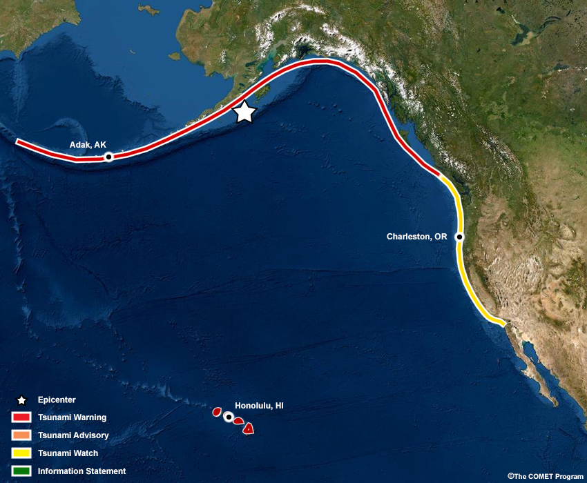
Deep ocean sensor observations indicate that a tsunami is occurring. The Tsunami Warning continues for the Alaska and Canada coastline, and a Tsunami Watch continues for the U.S. West Coast. Meanwhile, Hawaii has been upgraded to a Tsunami Warning. The magnitude of the earthquake has been upgraded from M8.2 to M8.6.
Timeline
Click on the graphic to see larger view.
Active Alerts
NTWC
    ...TEST Public Tsunami Message Number 2 ...TEST
    NWS National Tsunami Warning Center Palmer AK
    0905 AM AKDT Thu May 13 2022

    UPDATES
    -------
     * A tsunami has been confirmed and some impacts are expected
     * Revised magnitude


    ...THE TSUNAMI WARNING REMAINS IN EFFECT...


    ...THE TSUNAMI WATCH REMAINS IN EFFECT...


    Tsunami Warning in Effect for;

     * BRITISH COLUMBIA, The north coast and Haida Gwaii and the
       central coast and northeast Vancouver Island

     * SOUTHEAST ALASKA, The inner and outer coast from The
       BC/Alaska Border to Cape Fairweather, Alaska (80 miles SE
       of Yakutat)

     * SOUTH ALASKA AND THE ALASKA PENINSULA, Pacific coasts from
       Cape Fairweather, Alaska (80 miles SE of Yakutat) to Unimak
       Pass, Alaska (80 miles NE of Unalaska)

     * ALEUTIAN ISLANDS, Unimak Pass, Alaska (80 miles NE of
       Unalaska) to Attu, Alaska including the Pribilof Islands


    Tsunami Watch in Effect for;

     * CALIFORNIA, The coast from The Cal./Mexico Border to The
       Oregon/Cal. Border including San Francisco Bay

     * OREGON, The coast from The Oregon/Cal. Border to The
       Oregon/Wash. Border including the Columbia River estuary
       coast

     * WASHINGTON, Outer coast from the Oregon/Washington border
       to Slip Point, Columbia River estuary coast, and the Juan
       de Fuca Strait coast

     * BRITISH COLUMBIA, The outer west coast of Vancouver Island
       and the Juan de Fuca strait coast

    TEST...TEST...TEST...TEST...TEST...TEST...TEST...TEST...TEST...TEST

    PRELIMINARY EARTHQUAKE PARAMETERS - UPDATED
    -------------------------------------------

     * The following parameters are based on a rapid preliminary
       assessment of the earthquake and changes may occur.

     * Magnitude      8.6
     * Origin Time    0830 AKDT May 13 2022
                      0930  PDT May 13 2022
                      1630  UTC May 13 2022
     * Coordinates    55.2 North 156.7 West
     * Depth          11 miles
     * Location       100 miles SE of Chignik, Alaska
                      485 miles SW of Anchorage, Alaska

    TEST...TEST...TEST...TEST...TEST...TEST...TEST...TEST...TEST...TEST

    FORECASTS OF TSUNAMI ACTIVITY
    -----------------------------
     * Tsunami activity is forecasted to start at the following
       locations at the specified times.

                     FORECAST
                     START
    SITE             OF TSUNAMI
    ----             ----------

     * Alaska
    Sand Point       0925 AKDT May 13
    Kodiak           0955 AKDT May 13
    Unalaska         1000 AKDT May 13
    Elfin Cove       1020 AKDT May 13
    Seward           1020 AKDT May 13
    Cold Bay         1020 AKDT May 13
    Adak             1025 AKDT May 13
    Sitka            1030 AKDT May 13
    Yakutat          1030 AKDT May 13
    Valdez           1040 AKDT May 13
    Cordova          1050 AKDT May 13
    Shemya           1105 AKDT May 13
    Homer            1115 AKDT May 13
    Saint Paul       1120 AKDT May 13
    Craig            1130 AKDT May 13

     * British Columbia
    Langara          1140  PDT May 13
    Tofino           1305  PDT May 13

     * Washington
    La Push          1315  PDT May 13
    Neah Bay         1320  PDT May 13
    Long Beach       1325  PDT May 13
    Moclips          1330  PDT May 13
    Westport         1330  PDT May 13
    Port Angeles     1355  PDT May 13
    Port Townsend    1425  PDT May 13

     * Oregon
    Port Orford      1325  PDT May 13
    Charleston       1330  PDT May 13
    Seaside          1335  PDT May 13
    Newport          1335  PDT May 13
    Brookings        1335  PDT May 13

     * California
    Crescent City    1340  PDT May 13
    Fort Bragg       1345  PDT May 13
    Monterey         1410  PDT May 13
    San Francisco    1435  PDT May 13
    Port San Luis    1435  PDT May 13
    Santa Barbara    1450  PDT May 13
    Los Angeles Harb 1505  PDT May 13
    Newport Beach    1515  PDT May 13
    Oceanside        1520  PDT May 13
    La Jolla         1520  PDT May 13


    OBSERVATIONS OF TSUNAMI ACTIVITY
    --------------------------------
     * No tsunami observations are available to report.

    TEST...TEST...TEST...TEST...TEST...TEST...TEST...TEST...TEST...TEST

    RECOMMENDED ACTIONS
    -------------------
    Actions to protect human life and property will
    vary within tsunami warning areas.

    If you are in a tsunami warning area;

     * Evacuate inland or to higher ground above and beyond
       designated tsunami hazard zones or move to an upper floor
       of a multi-story building depending on your situation.

     * Move out of the water, off the beach, and away from
       harbors, marinas, breakwaters, bays and inlets.

     * Be alert to and follow instructions from your local
       emergency officials because they may have more detailed or
       specific information for your location.

     * If you feel a strong earthquake or extended ground rolling
       take immediate protective actions such as moving inland
       and/or uphill preferably by foot.

     * Boat operators,
         * Where time and conditions permit, move your boat out to
           sea to a depth of at least 180 feet.

         * If at sea avoid entering shallow water, harbors,
           marinas, bays, and inlets to avoid floating and
           submerged debris and strong currents.

     * Do not go to the shore to observe the tsunami.

     * Do not return to the coast until local emergency officials
       indicate it is safe to do so.

    If you are in a tsunami watch area;

     * Prepare to take action and stay alert for further
       information.


    IMPACTS
    -------
    Impacts will vary at different locations in the warning
    areas.

    If you are in a tsunami warning area;

     * A tsunami with damaging waves and powerful currents is
       possible.

     * Repeated coastal flooding is possible as waves arrive
       onshore, move inland, and drain back into the ocean.

     * Strong and unusual waves, currents and inland flooding
       can drown or injure people and weaken or destroy structures
       on land and in water.

     * Water filled with floating or submerged debris that can
       injure or kill people and weaken or destroy buildings and
       bridges is possible.

     * Strong and unusual currents and waves in harbors,
       marinas, bays, and inlets may be especially
       destructive.

     * Some impacts may continue for many hours to days after
       arrival of the first wave.

     * The first wave may not be the largest so later waves may
       be larger.

     * Each wave may last 5 to 45 minutes as a wave encroaches
       and recedes.

     * Coasts facing all directions are threatened because the
       waves can wrap around islands and headlands and into bays.

     * Strong shaking or rolling of the ground indicates an
       earthquake has occurred and a tsunami may be imminent.

     * A rapidly receding or receded shoreline, unusual waves and
       sounds, and strong currents are signs of a tsunami.

     * The tsunami may appear as water moving rapidly out to sea,
       a gentle rising tide like flood with no breaking wave,
       as a series of breaking waves, or a frothy wall of water.


    ADDITIONAL INFORMATION AND NEXT UPDATE
    --------------------------------------
     * Refer to the internet site tsunami.gov for more information.

     * Pacific coastal residents outside California, Oregon,
       Washington, British Columbia and Alaska should refer to the
       Pacific Tsunami Warning Center messages at tsunami.gov.

     * This message will be updated within 30 minutes.

    TEST...TEST...TEST...TEST...TEST...TEST...TEST...TEST...TEST...TEST
PTWC
    TEST... TSUNAMI MESSAGE NUMBER   2 ...TEST
    NWS PACIFIC TSUNAMI WARNING CENTER HONOLULU HI
    710 AM HST FRI MAY 13 2022

    TO - EMERGENCY MANAGEMENT IN THE STATE OF HAWAII

    SUBJECT - TSUNAMI WARNING UPGRADE.  REVISED MAGNITUDE TO 8.6

    THE TSUNAMI WATCH IS UPGRADED TO A TSUNAMI WARNING.  A TSUNAMI WARNING IS ISSUED FOR THE STATE OF HAWAII EFFECTIVE AT 0710 AM HST.
    A TSUNAMI HAS BEEN CONFIRMED ON DART 46403.

    TEST...TEST...TEST...TEST...TEST...TEST...TEST...TEST...TEST...TEST

    AN EARTHQUAKE HAS OCCURRED WITH THESE PRELIMINARY PARAMETERS

       ORIGIN TIME - 0635 AM HST 13 MAY 2022
       COORDINATES - 55.2 NORTH  156.7 WEST
       LOCATION    - SOUTH OF ALASKA
       UPGRADED MAGNITUDE   - 8.6  MOMENT

    TEST...TEST...TEST...TEST...TEST...TEST...TEST...TEST...TEST...TEST

    MEASUREMENTS OR REPORTS OF TSUNAMI WAVE ACTIVITY

     GAUGE LOCATION        LAT   LON    TIME        AMPL         PER
     -------------------  ----- ------  -----  ---------------  -----
     DART 46403           52.7N 156.8W  1704Z   1.46M /  4.8FT  16MIN

     LAT  - LATITUDE (N-NORTH, S-SOUTH)
     LON  - LONGITUDE (E-EAST, W-WEST)
     TIME - TIME OF THE MEASUREMENT (Z IS UTC IS GREENWICH TIME)
     AMPL - TSUNAMI AMPLITUDE MEASURED RELATIVE TO NORMAL SEA LEVEL.
            IT IS ...NOT... CREST-TO-TROUGH WAVE HEIGHT.
            VALUES ARE GIVEN IN BOTH METERS(M) AND FEET(FT).
     PER  - PERIOD OF TIME IN MINUTES(MIN) FROM ONE WAVE TO THE NEXT.

     NOTE - DART MEASUREMENTS ARE FROM THE DEEP OCEAN AND THEY
            ARE GENERALLY MUCH SMALLER THAN WOULD BE COASTAL
             MEASUREMENTS AT SIMILAR LOCATIONS.

    TEST...TEST...TEST...TEST...TEST...TEST...TEST...TEST...TEST...TEST

    EVALUATION

     A TSUNAMI HAS BEEN GENERATED THAT COULD CAUSE DAMAGE ALONG
     COASTLINES OF ALL ISLANDS IN THE STATE OF HAWAII. URGENT ACTION
     SHOULD BE TAKEN TO PROTECT LIVES AND PROPERTY.

     A TSUNAMI IS A SERIES OF LONG OCEAN WAVES. EACH INDIVIDUAL WAVE
     CREST CAN LAST 5 TO 15 MINUTES OR MORE AND EXTENSIVELY FLOOD
     COASTAL AREAS. THE DANGER CAN CONTINUE FOR MANY HOURS AFTER THE
     INITIAL WAVE AS SUBSEQUENT WAVES ARRIVE. TSUNAMI WAVE HEIGHTS
     CANNOT BE PREDICTED AND THE FIRST WAVE MAY NOT BE THE LARGEST.
     TSUNAMI WAVES EFFICIENTLY WRAP AROUND ISLANDS. ALL SHORES ARE AT
     RISK NO MATTER WHICH DIRECTION THEY FACE. THE TROUGH OF A TSUNAMI
     WAVE MAY TEMPORARILY EXPOSE THE SEAFLOOR BUT THE AREA WILL
     QUICKLY FLOOD AGAIN. EXTREMELY STRONG AND UNUSUAL NEARSHORE
     CURRENTS CAN ACCOMPANY A TSUNAMI. DEBRIS PICKED UP AND CARRIED
     BY A TSUNAMI AMPLIFIES ITS DESTRUCTIVE POWER. SIMULTANEOUS HIGH
     TIDES OR HIGH SURF CAN SIGNIFICANTLY INCREASE THE TSUNAMI HAZARD.

     THE ESTIMATED ARRIVAL TIME IN HAWAII OF THE FIRST TSUNAMI WAVE IS

                         1114 AM HST FRI 13 MAY 2022

    FURTHER MESSAGES WILL BE ISSUED HOURLY OR SOONER AS CONDITIONS
    WARRANT UNTIL THE THREAT TO HAWAII HAS PASSED.

    TEST...TEST...TEST...TEST...TEST...TEST...TEST...TEST...TEST...TEST
Question 2.1
You are back on a call with the public official from Adak, Alaska. What updated information will you pass along to her? (Choose the best answer.)
Please continue to the next question
Next Question →Question 2.2
The Charleston State Parks Manager in Coos County, Oregon calls your office (WFO-Medford) to ask if a tsunami has been confirmed yet. If so, they would like to know the latest information about the wave’s height and arrival time for their respective coastline. How will you respond? (Choose the best answer.)
Please continue to the next question
Next Question →Question 2.3
The local EM from Hawaii calls your office (WFO-Honolulu) to ask if a tsunami has been confirmed yet. If so, they would like to know the latest information about the wave’s height and arrival time for their respective coastline. How will you respond? (Choose the best answer.)
The correct answers are highlighted in green.
At this time, there is updated information about the magnitude of the earthquake. It is important to relay magnitude updates to decision-makers as it informs their unique response plans and conveys the potential for an impactful tsunami event. Concerns, and the potential for a tsunami having basin-wide impacts, increase with stronger earthquakes.
Because a tsunami has been confirmed, locations close to the earthquake source should be prepared for severe and immediate impacts, and know that the first wave may not be the only wave nor the largest. However, farther locations will have little additional information about the tsunami risk due to the lack of observations; the height of and areas potentially impacted by the tsunami waves remains unknown. Until observations come in, it is recommended to tell decision-makers “This is the best forecast at this time; please stand by for additional information that we will communicate as soon as possible”.
Continue to Next Time Step| TIME 1 05 min. after EQ |
TIME 2 35 min. after EQ |
TIME 3 1 hr 05 min. after EQ |
TIME 4 ~ 3 hrs. after EQ |
TIME 5 ~ 48 hrs. after EQ |
NTWC/PTWC Message to WFOs:
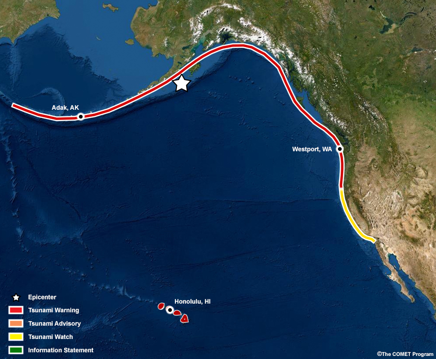
The TWCs have been receiving water displacement observations as the wave propagates away from the earthquake source. The observations have been ingested into models to provide better information about forecast wave arrivals at various locations, and to aid a forecaster’s confidence about what areas will be impacted. The waves are traveling quickly across the basin, and the Washington and Oregon coastlines have been upgraded to a Tsunami Warning. The Tsunami Warning continues for Hawaii. The magnitude of the earthquake has been upgraded from M8.6 to M9.1.
Timeline
Click on the graphic to see larger view.

Active Alerts
NTWC
    ...TEST Public Tsunami Message Number 3 ...TEST
    NWS National Tsunami Warning Center Palmer AK
    0935 AM AKDT Thu May 13 2022

    UPDATES
    -------
     * A tsunami has been confirmed and some impacts are expected
     * Updated observations
     * Revised alert areas
     * Revised magnitude
    Deep ocean pressure sensor data indicates a tsunami was generated.


    ...THE TSUNAMI WARNING REMAINS IN EFFECT...


    ...THE TSUNAMI WATCH REMAINS IN EFFECT...


    Tsunami Warning in Effect for;

     * OREGON, The coast from The Oregon/Cal. Border to The
       Oregon/Wash. Border including the Columbia River estuary
       coast

     * WASHINGTON, Outer coast from the Oregon/Washington border
       to Slip Point, Columbia River estuary coast, and the Juan
       de Fuca Strait coast

     * BRITISH COLUMBIA, The outer west coast of Vancouver Island
       and the Juan de Fuca strait coast

     * BRITISH COLUMBIA, The north coast and Haida Gwaii and the
       central coast and northeast Vancouver Island

     * SOUTHEAST ALASKA, The inner and outer coast from The
       BC/Alaska Border to Cape Fairweather, Alaska (80 miles SE
       of Yakutat)

     * SOUTH ALASKA AND THE ALASKA PENINSULA, Pacific coasts from
       Cape Fairweather, Alaska (80 miles SE of Yakutat) to Unimak
       Pass, Alaska (80 miles NE of Unalaska)

     * ALEUTIAN ISLANDS, Unimak Pass, Alaska (80 miles NE of
       Unalaska) to Attu, Alaska including the Pribilof Islands


    Tsunami Watch in Effect for;

     * CALIFORNIA, The coast from The Cal./Mexico Border to The
       Oregon/Cal. Border including San Francisco Bay

    TEST...TEST...TEST...TEST...TEST...TEST...TEST...TEST...TEST...TEST

    PRELIMINARY EARTHQUAKE PARAMETERS - UPDATED
    -------------------------------------------

     * Magnitude      9.1
     * Origin Time    0830 AKDT May 13 2022
                      0930  PDT May 13 2022
                      1630  UTC May 13 2022
     * Coordinates    55.2 North 156.7 West
     * Depth          11 miles
     * Location       100 miles SE of Chignik, Alaska
                      485 miles SW of Anchorage, Alaska

    TEST...TEST...TEST...TEST...TEST...TEST...TEST...TEST...TEST...TEST

    FORECASTS OF TSUNAMI ACTIVITY
    -----------------------------
     * Tsunami activity is forecasted to start at the following
       locations at the specified times.

                     FORECAST                        OBSERVED
                     START                            TSUNAMI
    SITE             OF TSUNAMI                        HEIGHT
    ----             ----------                        —-------

     * Alaska
    Sand Point       0910 AKDT May 13                    4.5FT
    Kodiak           0940 AKDT May 13
    Cold Bay         0945 AKDT May 13
    Unalaska         0950 AKDT May 13
    Seward           1010 AKDT May 13
    Adak             1015 AKDT May 13
    Elfin Cove       1015 AKDT May 13
    Sitka            1020 AKDT May 13
    Yakutat          1020 AKDT May 13
    Valdez           1030 AKDT May 13
    Cordova          1040 AKDT May 13
    Shemya           1100 AKDT May 13
    Homer            1105 AKDT May 13
    Saint Paul       1110 AKDT May 13
    Craig            1120 AKDT May 13

     * British Columbia
    Langara          1130  PDT May 13
    Tofino           1300  PDT May 13

     * Washington
    La Push          1305  PDT May 13
    Neah Bay         1310  PDT May 13
    Long Beach       1315  PDT May 13
    Moclips          1320  PDT May 13
    Westport         1325  PDT May 13
    Port Angeles     1350  PDT May 13
    Port Townsend    1415  PDT May 13

     * Oregon
    Port Orford      1320  PDT May 13
    Seaside          1325  PDT May 13
    Charleston       1325  PDT May 13
    Newport          1330  PDT May 13
    Brookings        1330  PDT May 13

     * California
    Crescent City    1335  PDT May 13
    Fort Bragg       1340  PDT May 13
    Monterey         1410  PDT May 13
    San Francisco    1430  PDT May 13
    Port San Luis    1435  PDT May 13
    Santa Barbara    1450  PDT May 13
    Los Angeles Harb 1505  PDT May 13
    Newport Beach    1510  PDT May 13
    La Jolla         1515  PDT May 13
    Oceanside        1515  PDT May 13

    OBSERVATIONS OF TSUNAMI ACTIVITY
    ------------------------------------------
     * Observed max tsunami height is the highest recorded water level
       above the tide level up to the time of this message.

                                      TIME               OBSERVED MAX
     SITE                         OF MEASUREMENT         TSUNAMI HEIGHT
     ---------------------------- ----------------       --------------
     Sand Point  Alaska                                     4.5 ft

    TEST...TEST...TEST...TEST...TEST...TEST...TEST...TEST...TEST...TEST

    RECOMMENDED ACTIONS
    -------------------
    Actions to protect human life and property will
    vary within tsunami warning areas.

    If you are in a tsunami warning area;

     * Evacuate inland or to higher ground above and beyond
       designated tsunami hazard zones or move to an upper floor
       of a multi-story building depending on your situation.

     * Move out of the water, off the beach, and away from
       harbors, marinas, breakwaters, bays and inlets.

     * Be alert to and follow instructions from your local
       emergency officials because they may have more detailed or
       specific information for your location.

     * If you feel a strong earthquake or extended ground rolling
       take immediate protective actions such as moving inland
       and/or uphill preferably by foot.

     * Boat operators,
         * Where time and conditions permit, move your boat out to
           sea to a depth of at least 180 feet.

         * If at sea avoid entering shallow water, harbors,
           marinas, bays, and inlets to avoid floating and
           submerged debris and strong currents.

     * Do not go to the shore to observe the tsunami.

     * Do not return to the coast until local emergency officials
       indicate it is safe to do so.

    If you are in a tsunami watch area;

     * Prepare to take action and stay alert for further
       information.


    IMPACTS
    -------
    Impacts will vary at different locations in the warning
    areas.

    If you are in a tsunami warning area;

     * A tsunami with damaging waves and powerful currents is
       possible.

     * Repeated coastal flooding is possible as waves arrive
       onshore, move inland, and drain back into the ocean.

     * Strong and unusual waves, currents and inland flooding
       can drown or injure people and weaken or destroy structures
       on land and in water.

     * Water filled with floating or submerged debris that can
       injure or kill people and weaken or destroy buildings and
       bridges is possible.

     * Strong and unusual currents and waves in harbors,
       marinas, bays, and inlets may be especially
       destructive.

     * Some impacts may continue for many hours to days after
       arrival of the first wave.

     * The first wave may not be the largest so later waves may
       be larger.

     * Each wave may last 5 to 45 minutes as a wave encroaches
       and recedes.

     * Coasts facing all directions are threatened because the
       waves can wrap around islands and headlands and into bays.

     * Strong shaking or rolling of the ground indicates an
       earthquake has occurred and a tsunami may be imminent.

     * A rapidly receding or receded shoreline, unusual waves and
       sounds, and strong currents are signs of a tsunami.

     * The tsunami may appear as water moving rapidly out to sea,
       a gentle rising tide like flood with no breaking wave,
       as a series of breaking waves, or a frothy wall of water.


    ADDITIONAL INFORMATION AND NEXT UPDATE
    --------------------------------------
     * Refer to the internet site tsunami.gov for more information.

     * Pacific coastal residents outside California, Oregon,
       Washington, British Columbia and Alaska should refer to the
       Pacific Tsunami Warning Center messages at tsunami.gov.

     * This message will be updated within 30 minutes.


    TEST...TEST...TEST...TEST...TEST...TEST...TEST...TEST...TEST...TEST
PTWC
    TEST... TSUNAMI MESSAGE NUMBER   3 ...TEST
    NWS PACIFIC TSUNAMI WARNING CENTER HONOLULU HI
    735 AM HST FRI MAY 13 2022

    TO - EMERGENCY MANAGEMENT IN THE STATE OF HAWAII

    SUBJECT - TSUNAMI WARNING SUPPLEMENT.  UPGRADED MAGNITUDE TO 9.1

    A TSUNAMI WARNING CONTINUES IN EFFECT FOR THE STATE OF HAWAII.

    TEST...TEST...TEST...TEST...TEST...TEST...TEST...TEST...TEST...TEST

    AN EARTHQUAKE HAS OCCURRED WITH THESE PRELIMINARY PARAMETERS

       ORIGIN TIME - 0635 AM HST 13 MAY 2022
       COORDINATES - 55.2 NORTH  156.7 WEST
       LOCATION    - SOUTH OF ALASKA
       UPGRADED MAGNITUDE   - 9.1  MOMENT

    TEST...TEST...TEST...TEST...TEST...TEST...TEST...TEST...TEST...TEST

    MEASUREMENTS OR REPORTS OF TSUNAMI WAVE ACTIVITY

     GAUGE LOCATION        LAT   LON    TIME        AMPL         PER
     -------------------  ----- ------  -----  ---------------  -----
     DART 46409           55.3N 148.6W  1726Z   0.51M /  1.7FT  24MIN
     DART 46414           53.7N 152.5W  1712Z   1.42M /  4.7FT  22MIN
     DART 46403           52.7N 156.8W  1704Z   1.46M /  4.8FT  16MIN
     SAND POINT AK        55.3N 160.5W  1929Z   1.37M /  4.5FT  26MIN

     LAT  - LATITUDE (N-NORTH, S-SOUTH)
     LON  - LONGITUDE (E-EAST, W-WEST)
     TIME - TIME OF THE MEASUREMENT (Z IS UTC IS GREENWICH TIME)
     AMPL - TSUNAMI AMPLITUDE MEASURED RELATIVE TO NORMAL SEA LEVEL.
            IT IS ...NOT... CREST-TO-TROUGH WAVE HEIGHT.
            VALUES ARE GIVEN IN BOTH METERS(M) AND FEET(FT).
     PER  - PERIOD OF TIME IN MINUTES(MIN) FROM ONE WAVE TO THE NEXT.

     NOTE - DART MEASUREMENTS ARE FROM THE DEEP OCEAN AND THEY
            ARE GENERALLY MUCH SMALLER THAN WOULD BE COASTAL
             MEASUREMENTS AT SIMILAR LOCATIONS.

    TEST...TEST...TEST...TEST...TEST...TEST...TEST...TEST...TEST...TEST

    EVALUATION

     A TSUNAMI HAS BEEN GENERATED THAT COULD CAUSE DAMAGE ALONG
     COASTLINES OF ALL ISLANDS IN THE STATE OF HAWAII. URGENT ACTION
     SHOULD BE TAKEN TO PROTECT LIVES AND PROPERTY.

     A TSUNAMI IS A SERIES OF LONG OCEAN WAVES. EACH INDIVIDUAL WAVE
     CREST CAN LAST 5 TO 15 MINUTES OR MORE AND EXTENSIVELY FLOOD
     COASTAL AREAS. THE DANGER CAN CONTINUE FOR MANY HOURS AFTER THE
     INITIAL WAVE AS SUBSEQUENT WAVES ARRIVE. TSUNAMI WAVE HEIGHTS
     CANNOT BE PREDICTED AND THE FIRST WAVE MAY NOT BE THE LARGEST.
     TSUNAMI WAVES EFFICIENTLY WRAP AROUND ISLANDS. ALL SHORES ARE AT
     RISK NO MATTER WHICH DIRECTION THEY FACE. THE TROUGH OF A TSUNAMI
     WAVE MAY TEMPORARILY EXPOSE THE SEAFLOOR BUT THE AREA WILL
     QUICKLY FLOOD AGAIN. EXTREMELY STRONG AND UNUSUAL NEARSHORE
     CURRENTS CAN ACCOMPANY A TSUNAMI. DEBRIS PICKED UP AND CARRIED
     BY A TSUNAMI AMPLIFIES ITS DESTRUCTIVE POWER. SIMULTANEOUS HIGH
     TIDES OR HIGH SURF CAN SIGNIFICANTLY INCREASE THE TSUNAMI HAZARD.

     THE ESTIMATED ARRIVAL TIME IN HAWAII OF THE FIRST TSUNAMI WAVE IS

                         1114 AM HST FRI 13 MAY 2022

    FURTHER MESSAGES WILL BE ISSUED HOURLY OR SOONER AS CONDITIONS
    WARRANT UNTIL THE THREAT TO HAWAII HAS PASSED.

    TEST...TEST...TEST...TEST...TEST...TEST...TEST...TEST...TEST...TEST
Question 3.1
The public official from Adak, Alaska calls back to report wave activity and strong currents along the bay coastline. What can you tell them about expected impacts and how long the event will continue? (Choose the best answer.)
Please continue to the next question
Next Question →Question 3.2
The Westport EM in Grays Harbor County, Washington calls your office (WFO-Seattle) to ask if any new information has come in regarding the characteristics of the tsunami, and how confident you are in the areas that will be impacted. How will you respond? (Choose the best answer.)
The correct answers are highlighted in green.
It is important to provide location-specific threats and impact information as provided in the TWC products, and emphasize the long-term duration of impacts post-wave arrival so that decision-makers can execute their particular community response plans with sufficient resources. Otherwise, decision-makers may underestimate the severity of the event, potentially resulting in under-evacuation and greafter loss of life. In addition to tsunami characteristics, a forecaster’s confidence in tsunami details should be conveyed to the extent that comes directly from the TWC products, not based on personal subjectivity. Confidence can be relayed through tsunami confirmation and providing the best information from the TWC products.
Despite initial wave observations, you should not assume nor relay that any location close to the earthquake source has already experienced the worst of the event, as it could miscommunicate to local decision-makers that the event is over. For farther locations, wave forecast information will be provided and refined as more observations come in.
Continue to Next Time Step| TIME 1 05 min. after EQ |
TIME 2 35 min. after EQ |
TIME 3 1 hr 05 min. after EQ |
TIME 4 ~ 3 hrs. after EQ |
TIME 5 ~ 48 hrs. after EQ |
NTWC/PTWC Message to WFOs:
The Hawaii, Washington and Oregon coasts continue to be under a Tsunami Warning, and wave arrival is imminent for the northernmost locations of the Washington shoreline. The California coast is now in a Tsunami Warning. The westernmost areas of the Alaska Aleutian Islands coastline has been downgraded to a Tsunami Advisory, as observations show that water fluctuations have begun to subside from the initial high levels.
Timeline
Click on the graphic to see larger view.
Active Alerts
NTWC
    ...TEST Public Tsunami Message Number 6 ...TEST
    NWS National Tsunami Warning Center Palmer AK
    1135 AM AKDT Thu May 13 2022

    UPDATES
    -------
     * A tsunami has been confirmed and some impacts are expected
     * Updated observations


    ...THE TSUNAMI WARNING REMAINS IN EFFECT...


    ...A TSUNAMI ADVISORY IS NOW IN EFFECT...


    Tsunami Warning in Effect for;

     * CALIFORNIA, The coast from The Cal./Mexico Border to The
       Oregon/Cal. Border including San Francisco Bay

     * OREGON, The coast from The Oregon/Cal. Border to The
       Oregon/Wash. Border including the Columbia River estuary
       coast

     * WASHINGTON, Outer coast from the Oregon/Washington border
       to Slip Point, Columbia River estuary coast, and the Juan
       de Fuca Strait coast

     * BRITISH COLUMBIA, The north coast and Haida Gwaii, the
       central coast and northeast Vancouver Island, the outer
       west coast of Vancouver Island, the Juan de Fuca Strait
       coast

     * SOUTHEAST ALASKA, The inner and outer coast from The
       BC/Alaska Border to Cape Fairweather, Alaska (80 miles SE
       of Yakutat)

     * SOUTH ALASKA AND THE ALASKA PENINSULA, Pacific coasts from
       Cape Fairweather, Alaska (80 miles SE of Yakutat) to Unimak
       Pass, Alaska (80 miles NE of Unalaska)

     * ALEUTIAN ISLANDS, Unimak Pass, Alaska (80 miles NE of
       Unalaska) to Samalga Pass, Alaska (30 miles SW of Nikolski)


    Tsunami Advisory in Effect for;

     * ALEUTIAN ISLANDS, Samalga Pass, Alaska (30 miles SW of
       Nikolski) to Attu, Alaska including the Pribilof Islands

    TEST...TEST...TEST...TEST...TEST...TEST...TEST...TEST...TEST...TEST

    PRELIMINARY EARTHQUAKE PARAMETERS
    ---------------------------------

     * Magnitude      9.1
     * Origin Time    0830 AKDT May 13 2022
                      0930  PDT May 13 2022
                      1630  UTC May 13 2022
     * Coordinates    55.2 North 156.7 West
     * Depth          11 miles
     * Location       100 miles SE of Chignik, Alaska
                      485 miles SW of Anchorage, Alaska

    TEST...TEST...TEST...TEST...TEST...TEST...TEST...TEST...TEST...TEST

    FORECASTS OF TSUNAMI ACTIVITY
    -----------------------------
     * A tsunami has been generated.  The first waves are forecasted to
       arrive at the following locations and specified times.

     * Forecast tsunami duration is the approximate length of time which
       the tsunami may produce dangerous currents and waves.

     * Forecast max tsunami height is the highest expected water level
       above the tide.

     * Forecasts are not provided for sites which have been impacted
       more than an hour prior to the time of this message.

                     FORECAST         FORECAST  FORECAST
                     START            TSUNAMI   MAX TSUNAMI
    SITE             OF TSUNAMI       DURATION  HEIGHT
    ----             ----------       --------  -------------

     * Alaska
    Sand Point       0910 AKDT May 13  48 hrs    7.5-13.9 ft
    Kodiak           0940 AKDT May 13  48 hrs    4.8- 8.9 ft
    Cold Bay         0945 AKDT May 13  24 hrs    2.3- 4.2 ft
    Unalaska         0950 AKDT May 13  24 hrs    2.2- 4.1 ft
    Seward           1010 AKDT May 13  30 hrs    2.6- 4.9 ft
    Adak             1015 AKDT May 13  15 hrs    0.9- 1.8 ft
    Elfin Cove       1015 AKDT May 13  15 hrs    1.1- 2.0 ft
    Sitka            1020 AKDT May 13  24 hrs    2.2- 4.0 ft
    Yakutat          1020 AKDT May 13  30 hrs    2.5- 4.7 ft
    Valdez           1030 AKDT May 13   9 hrs    0.8- 1.5 ft
    Cordova          1040 AKDT May 13   9 hrs    0.9- 1.7 ft
    Shemya           1100 AKDT May 13           less than 1ft
    Homer            1105 AKDT May 13  24 hrs    1.9- 3.6 ft
    Saint Paul       1110 AKDT May 13           less than 1ft
    Craig            1120 AKDT May 13

     * British Columbia
    Langara          1130  PDT May 13  15 hrs    1.0- 1.8 ft
    Tofino           1300  PDT May 13  20 hrs    1.8- 3.4 ft

     * Washington
    La Push          1305  PDT May 13
    Neah Bay         1310  PDT May 13  20 hrs    1.4- 2.7 ft
    Long Beach       1315  PDT May 13  36 hrs    2.9- 5.3 ft
    Moclips          1320  PDT May 13  40 hrs    3.4- 6.3 ft
    Westport         1325  PDT May 13  40 hrs    3.2- 6.0 ft
    Port Angeles     1350  PDT May 13  20 hrs    1.7- 3.2 ft
    Port Townsend    1415  PDT May 13  20 hrs    1.5- 2.9 ft

     * Oregon
    Port Orford      1320  PDT May 13  48 hrs    4.5- 8.4 ft
    Seaside          1325  PDT May 13
    Charleston       1325  PDT May 13  40 hrs    3.8- 7.0 ft
    Newport          1330  PDT May 13
    Brookings        1330  PDT May 13  40 hrs    3.7- 6.9 ft

     * California
    Crescent City    1335  PDT May 13  48 hrs    5.6-10.5 ft
    Fort Bragg       1340  PDT May 13  40 hrs    3.4- 6.4 ft
    Monterey         1410  PDT May 13  36 hrs    3.0- 5.6 ft
    San Francisco    1430  PDT May 13  30 hrs    2.6- 4.9 ft
    Port San Luis    1435  PDT May 13  48 hrs    9.2-17.1 ft
    Santa Barbara    1450  PDT May 13  30 hrs    2.5- 4.7 ft
    Los Angeles Harb 1505  PDT May 13  15 hrs    1.0- 1.9 ft
    Newport Beach    1510  PDT May 13  20 hrs    1.4- 2.6 ft
    La Jolla         1515  PDT May 13  24 hrs    2.2- 4.1 ft
    Oceanside        1515  PDT May 13  30 hrs    2.3- 4.3 ft


    OBSERVATIONS OF TSUNAMI ACTIVITY - UPDATED
    ------------------------------------------
     * Observed max tsunami height is the highest recorded water level
       above the tide level up to the time of this message.

                                      TIME               OBSERVED MAX
     SITE                         OF MEASUREMENT         TSUNAMI HEIGHT
     ---------------------------- ----------------       --------------
     Sand Point  Alaska                                     11.6ft
     Chignik Bay  Alaska                                    21.8ft
     Kodiak  Alaska                                          4.5ft
     Unalaska  Alaska                                        1.4ft
     Seward  Alaska                                          3.2ft
     Adak  Alaska                                            0.9ft
     Elfin Cove  Alaska                                      1.3ft
     Sitka  Alaska                                           3.7ft
     Yakutat  Alaska                                         1.7ft
     Cordova  Alaska                                         0.9ft
     Shemya  Alaska                                          0.3ft
     Craig  Alaska                                           2.8ft
     La Push  Washington                                     3.1ft

    TEST...TEST...TEST...TEST...TEST...TEST...TEST...TEST...TEST...TEST

    RECOMMENDED ACTIONS - UPDATED
    -----------------------------
    Actions to protect human life and property will
    vary within tsunami warning areas and within tsunami
    advisory areas.

    If you are in a tsunami warning area;

     * Evacuate inland or to higher ground above and beyond
       designated tsunami hazard zones or move to an upper floor
       of a multi-story building depending on your situation.

    If you are in a tsunami warning or advisory area;

     * Move out of the water, off the beach, and away from
       harbors, marinas, breakwaters, bays and inlets.

     * Be alert to and follow instructions from your local
       emergency officials because they may have more detailed or
       specific information for your location.

     * If you feel a strong earthquake or extended ground rolling
       take immediate protective actions such as moving inland
       and/or uphill preferably by foot.

     * Boat operators,
         * Where time and conditions permit, move your boat out to
           sea to a depth of at least 180 feet.

         * If at sea avoid entering shallow water, harbors,
           marinas, bays, and inlets to avoid floating and
           submerged debris and strong currents.

     * Do not go to the shore to observe the tsunami.

     * Do not return to the coast until local emergency officials
       indicate it is safe to do so.


    IMPACTS
    -------
    Impacts will vary at different locations in the warning and
    in the advisory areas.

    If you are in a tsunami warning area;

     * A tsunami with damaging waves and powerful currents is
       possible.

     * Repeated coastal flooding is possible as waves arrive
       onshore, move inland, and drain back into the ocean.

     * Strong and unusual waves, currents and inland flooding
       can drown or injure people and weaken or destroy structures
       on land and in water.

     * Water filled with floating or submerged debris that can
       injure or kill people and weaken or destroy buildings and
       bridges is possible.

     * Strong and unusual currents and waves in harbors,
       marinas, bays, and inlets may be especially
       destructive.

    If you are in a tsunami advisory area;

     * A tsunami with strong waves and currents is possible.

     * Waves and currents can drown or injure people who are
       in the water.

     * Currents at beaches and in harbors, marinas,
       bays, and inlets may be especially dangerous.

    If you are in a tsunami warning or advisory area;

     * Some impacts may continue for many hours to days after
       arrival of the first wave.

     * The first wave may not be the largest so later waves may
       be larger.

     * Each wave may last 5 to 45 minutes as a wave encroaches
       and recedes.

     * Coasts facing all directions are threatened because the
       waves can wrap around islands and headlands and into bays.

     * Strong shaking or rolling of the ground indicates an
       earthquake has occurred and a tsunami may be imminent.

     * A rapidly receding or receded shoreline, unusual waves and
       sounds, and strong currents are signs of a tsunami.

     * The tsunami may appear as water moving rapidly out to sea,
       a gentle rising tide like flood with no breaking wave,
       as a series of breaking waves, or a frothy wall of water.


    ADDITIONAL INFORMATION AND NEXT UPDATE
    --------------------------------------
     * Refer to the internet site tsunami.gov for more information.

     * Pacific coastal residents outside California, Oregon,
       Washington, British Columbia and Alaska should refer to the
       Pacific Tsunami Warning Center messages at tsunami.gov.

     * This message will be updated within 30 minutes.

    TEST...TEST...TEST...TEST...TEST...TEST...TEST...TEST...TEST...TEST
PTWC
    TEST... TSUNAMI MESSAGE NUMBER   5 ...TEST
    NWS PACIFIC TSUNAMI WARNING CENTER HONOLULU HI
    935 AM HST FRI MAY 13 2022

    TO - EMERGENCY MANAGEMENT IN THE STATE OF HAWAII

    SUBJECT - TSUNAMI WARNING SUPPLEMENT

    A TSUNAMI WARNING CONTINUES IN EFFECT FOR THE STATE OF HAWAII.

    TEST...TEST...TEST...TEST...TEST...TEST...TEST...TEST...TEST...TEST


    AN EARTHQUAKE HAS OCCURRED WITH THESE PRELIMINARY PARAMETERS

       ORIGIN TIME - 0635 AM HST 13 MAY 2022
       COORDINATES - 55.2 NORTH  156.7 WEST
       LOCATION    - SOUTH OF ALASKA
       MAGNITUDE   - 9.1  MOMENT

    TEST...TEST...TEST...TEST...TEST...TEST...TEST...TEST...TEST...TEST


    MEASUREMENTS OR REPORTS OF TSUNAMI WAVE ACTIVITY

     GAUGE LOCATION        LAT   LON    TIME        AMPL         PER
     -------------------  ----- ------  -----  ---------------  -----
     ALITAK US            56.9N 154.2W  1933Z  17.68M / 58.0FT  26MIN
     SITKA AK             57.1N 135.3W  1932Z   2.06M /  6.8FT  22MIN
     SITKA AK             57.1N 135.3W  1930Z   2.06M /  6.8FT  18MIN
     ATKA AK              52.2N 174.2W  1934Z   0.51M /  1.7FT  28MIN
     ROSE HARBOUR CA      52.2N 131.1W  1934Z   2.57M /  8.4FT  24MIN
     CRAIG AK             55.5N 133.1W  1925Z   2.06M /  6.8FT  14MIN
     SAND POINT AK        55.3N 160.5W  1929Z  17.87M / 58.6FT  26MIN
     SAND POINT AK        55.3N 160.5W  1926Z  17.87M / 58.6FT  28MIN
     DART 21415           50.2N 171.9E  1922Z   0.07M /  0.2FT  28MIN
     HENSLUNG COVE CA     54.2N 133.0W  1908Z   2.07M /  6.8FT  22MIN
     KING COVE AK         55.1N 162.3W  1909Z   5.23M / 17.1FT  16MIN
     AMCHITKA AK          51.4N 179.3E  1907Z   0.72M /  2.4FT  28MIN
     PORT ALEXANDER AK    56.2N 134.6W  1909Z   2.04M /  6.7FT  22MIN
     ELFIN COVE AK        58.2N 136.3W  1907Z   1.85M /  6.1FT  28MIN
     DART 46416           49.9N 134.4W  1902Z   0.30M /  1.0FT  16MIN
     ADAK AK              51.9N 176.6W  1902Z   0.52M /  1.7FT  18MIN
     CORDOVA AK           60.6N 145.8W  1900Z   1.64M /  5.4FT  20MIN
     YAKUTAT AK           59.5N 139.7W  1854Z   1.65M /  5.4FT  24MIN
     DART 21414           49.0N 178.2E  1859Z   0.07M /  0.2FT  26MIN
     SEWARD AK            60.1N 149.4W  1854Z   1.66M /  5.4FT  18MIN
     DUTCH HBR UNALASKA   53.9N 166.5W  1852Z   0.86M /  2.8FT  26MIN
     AKUTAN AK            54.1N 165.8W  1840Z   0.86M /  2.8FT  26MIN
     DART 46413           48.0N 174.2W  1836Z   0.10M /  0.3FT  26MIN
     CHIGNIK AK           56.3N 158.4W  1831Z   9.97M / 32.7FT  20MIN
     NIKOLSKI AK          52.9N 168.9W  1831Z   0.68M /  2.2FT  22MIN
     DART 46415           53.0N 139.9W  1824Z   0.37M /  1.2FT  22MIN
     OLD HARBOR AK        57.2N 153.3W  1813Z  11.26M / 36.9FT  16MIN
     DART 46408           49.7N 169.9W  1808Z   0.13M /  0.4FT  24MIN
     DART 46410           57.6N 143.8W  1759Z   0.27M /  0.9FT  14MIN
     DART 46402           51.0N 164.1W  1745Z   0.35M /  1.1FT  20MIN
     DART 46409           55.3N 148.6W  1726Z   0.51M /  1.7FT  24MIN
     DART 46414           53.7N 152.5W  1712Z   1.42M /  4.7FT  22MIN
     DART 46403           52.7N 156.8W  1704Z   1.46M /  4.8FT  16MIN

     LAT  - LATITUDE (N-NORTH, S-SOUTH)
     LON  - LONGITUDE (E-EAST, W-WEST)
     TIME - TIME OF THE MEASUREMENT (Z IS UTC IS GREENWICH TIME)
     AMPL - TSUNAMI AMPLITUDE MEASURED RELATIVE TO NORMAL SEA LEVEL.
            IT IS ...NOT... CREST-TO-TROUGH WAVE HEIGHT.
            VALUES ARE GIVEN IN BOTH METERS(M) AND FEET(FT).
     PER  - PERIOD OF TIME IN MINUTES(MIN) FROM ONE WAVE TO THE NEXT.

     NOTE - DART MEASUREMENTS ARE FROM THE DEEP OCEAN AND THEY
            ARE GENERALLY MUCH SMALLER THAN WOULD BE COASTAL
             MEASUREMENTS AT SIMILAR LOCATIONS.

    TEST...TEST...TEST...TEST...TEST...TEST...TEST...TEST...TEST...TEST

    EVALUATION

     A TSUNAMI HAS BEEN GENERATED THAT COULD CAUSE DAMAGE ALONG
     COASTLINES OF ALL ISLANDS IN THE STATE OF HAWAII. URGENT ACTION
     SHOULD BE TAKEN TO PROTECT LIVES AND PROPERTY.

     A TSUNAMI IS A SERIES OF LONG OCEAN WAVES. EACH INDIVIDUAL WAVE
     CREST CAN LAST 5 TO 15 MINUTES OR MORE AND EXTENSIVELY FLOOD
     COASTAL AREAS. THE DANGER CAN CONTINUE FOR MANY HOURS AFTER THE
     INITIAL WAVE AS SUBSEQUENT WAVES ARRIVE. TSUNAMI WAVE HEIGHTS
     CANNOT BE PREDICTED AND THE FIRST WAVE MAY NOT BE THE LARGEST.
     TSUNAMI WAVES EFFICIENTLY WRAP AROUND ISLANDS. ALL SHORES ARE AT
     RISK NO MATTER WHICH DIRECTION THEY FACE. THE TROUGH OF A TSUNAMI
     WAVE MAY TEMPORARILY EXPOSE THE SEAFLOOR BUT THE AREA WILL
     QUICKLY FLOOD AGAIN. EXTREMELY STRONG AND UNUSUAL NEARSHORE
     CURRENTS CAN ACCOMPANY A TSUNAMI. DEBRIS PICKED UP AND CARRIED
     BY A TSUNAMI AMPLIFIES ITS DESTRUCTIVE POWER. SIMULTANEOUS HIGH
     TIDES OR HIGH SURF CAN SIGNIFICANTLY INCREASE THE TSUNAMI HAZARD.

     THE ESTIMATED ARRIVAL TIME IN HAWAII OF THE FIRST TSUNAMI WAVE IS

                         1114 AM HST FRI 13 MAY 2022

    FURTHER MESSAGES WILL BE ISSUED HOURLY OR SOONER AS CONDITIONS
    WARRANT UNTIL THE THREAT TO HAWAII HAS PASSED.

    TEST...TEST...TEST...TEST...TEST...TEST...TEST...TEST...TEST...TEST
Question 4.1
The public official from Adak, Alaska calls back to tell you that they noticed previously warned regions in Alaska have been downgraded to a Tsunami Advisory. She asks if the advisory means that tsunami waves are no longer a threat to the Alaska coastal areas. How will you respond? (Choose the best answer.)
Please continue to the next question
Next Question →Question 4.2
You are preparing a briefing to the Long Beach EM in Pacific County along the Washington Coast. She is asking if there are any changes to what you expect as the inundation hazard becomes imminent, how long the waves will last, and which wave will be the largest. How will you respond? (Choose the best answer.)
Please continue to the next question
Next Question →Question 4.3
You are on the phone with the EM from Honolulu, Hawaii. She is asking if there are any changes to what you expect as the inundation hazard becomes imminent. How will you respond? Choose the best answer.
The correct answers are highlighted in green.
When communicating forecast wave heights to decision-makers, it is important to convey a range of wave heights that a location should be prepared for, as long as they are part of the official TWC product. It is difficult to predict the exact wave heights that are expected to occur at long lead times.
Additionally, continue adhering to and communicating the information and implications of the alert in the TWC products. You should not assume or communicate that the tsunami impacts are subsiding as a result of an alert downgrade. Tsunamis are not a single large breaking wave; tsunami events are long-term events in which impacts can be felt well beyond the wave arrival. Surfing and other activities should be discouraged, and beaches should be closed. Also, it is the responsibility of local EMs or other municipal partners to determine when evacuation orders can be lifted and residents are allowed to return.
Despite having tsunami wave observations, you should not correlate experiences from Alaska and the U.S. West Coast with what will be observed along Hawaii's shorelines. Wave height forecasts for Hawaii are not included in public products. It is important to note that tsunami energy is not consistent across the basin. All locations impacted will not observe the same effects.
Continue to Next Time Step| TIME 1 05 min. after EQ |
TIME 2 35 min. after EQ |
TIME 3 1 hr 05 min. after EQ |
TIME 4 ~ 3 hrs. after EQ |
TIME 5 ~ 48 hrs. after EQ |
NTWC/PTWC Message to WFOs:
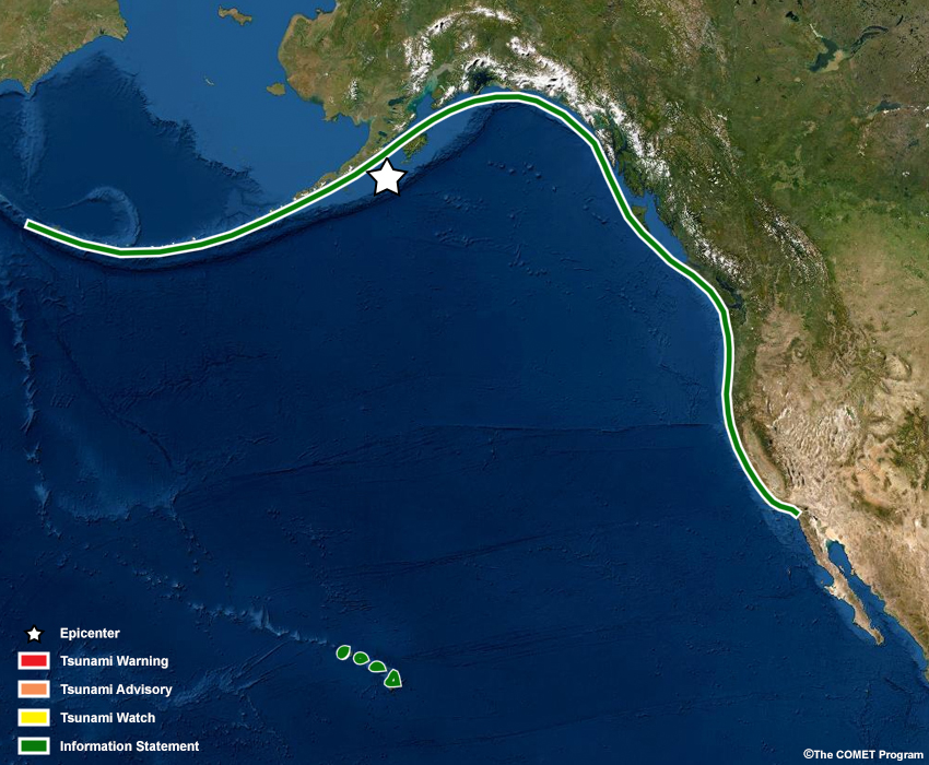
Almost two days have passed since the initial earthquake occurred. Local WFOs in many areas may still be dealing with the impacts of the tsunami, issuing information statements or other products. There will be a point after the tsunami "arrival" when measurable waves above normal tide have ceased for a specified number of hours, and that is when TWC will cancel any remaining Tsunami Warnings or Advisories. At this time, all Tsunami Warnings and Advisories are canceled for Alaska, Canada, and the U.S. West Coast.
Timeline
Click on the graphic to see larger view.

Active Alerts
NTWC
    ...TEST Public Tsunami Message Number 49 ...TEST
    NWS National Tsunami Warning Center Palmer AK
    0725 AM AKDT Thu May 15 2022

    ...THE TSUNAMI ADVISORY IS CANCELLED...

     * The Tsunami Advisory is canceled for the coastal areas of
       California and Oregon

     * The Tsunami Advisory is canceled for the coastal areas of
       South Alaska and the Alaska Peninsula

    TEST...TEST...TEST...TEST...TEST...TEST...TEST...TEST...TEST...TEST

    OBSERVATIONS OF TSUNAMI ACTIVITY - UPDATED
    ------------------------------------------
     * Observed max tsunami height is the highest recorded water level
       above the tide level up to the time of this message.

                                      TIME               OBSERVED MAX
     SITE                         OF MEASUREMENT         TSUNAMI HEIGHT
     ---------------------------- ----------------       --------------
     Sand Point  Alaska                                     11.6ft
     Chignik Bay  Alaska                                    21.8ft
     Kodiak  Alaska                                          4.5ft
     Unalaska  Alaska                                        1.4ft
     Seward  Alaska                                          3.2ft
     Adak  Alaska                                            0.9ft
     Elfin Cove  Alaska                                      1.3ft
     Sitka  Alaska                                           3.7ft
     Yakutat  Alaska                                         1.7ft
     Cordova  Alaska                                         0.9ft
     Shemya  Alaska                                          0.3ft
     Craig  Alaska                                           2.8ft
     La Push  Washington                                     3.1ft

    TEST...TEST...TEST...TEST...TEST...TEST...TEST...TEST...TEST...TEST

    RECOMMENDED ACTIONS - UPDATED
    -----------------------------
     * Do not re-occupy hazard zones until local emergency officials
       indicate it is safe to do so.


    IMPACTS - UPDATED
    -----------------
     * Tsunami activity has subsided along the coasts of the U.S.
       west coast states, British Columbia, and Alaska.

     * Ongoing activity may persist in some areas causing strong
       currents dangerous to swimmers and boats.

     * The determination to re-occupy hazard zones must be made
       by local officials.


    ADDITIONAL INFORMATION AND NEXT UPDATE
    --------------------------------------
     * Refer to the internet site tsunami.gov for more information.

     * Pacific coastal regions outside California, Oregon,
       Washington, British Columbia, and Alaska should refer to the
       Pacific Tsunami Warning Center messages at tsunami.gov.

     * This will be the final U.S. National Tsunami Warning Center
       message issued for this event.


    TEST...TEST...TEST...TEST...TEST...TEST...TEST...TEST...TEST...TEST
PTWC
TEST... TSUNAMI MESSAGE NUMBER 51 ...TEST
NWS PACIFIC TSUNAMI WARNING CENTER HONOLULU HI
525 AM HST SUN MAY 15 2022
TO - EMERGENCY MANAGEMENT IN THE STATE OF HAWAII
SUBJECT - TSUNAMI WARNING CANCELLATION
THE TSUNAMI WARNING IS CANCELLED FOR THE STATE OF HAWAII EFFECTIVE
AT 0525 AM HST.
TEST...TEST...TEST...TEST...TEST...TEST...TEST...TEST...TEST...TEST
AN EARTHQUAKE HAS OCCURRED WITH THESE PRELIMINARY PARAMETERS
ORIGIN TIME - 0635 AM HST 13 MAY 2022
COORDINATES - 55.2 NORTH 156.7 WEST
LOCATION - SOUTH OF ALASKA
MAGNITUDE - 9.1 MOMENT
TEST...TEST...TEST...TEST...TEST...TEST...TEST...TEST...TEST...TEST
MEASUREMENTS OR REPORTS OF TSUNAMI WAVE ACTIVITY
GAUGE LOCATION LAT LON TIME AMPL PER
------------------- ----- ------ ----- --------------- -----
ROTHERA ANTARCTICA 67.6S 68.1W 1358Z 1.91M / 6.3FT 26MIN
CALETA METEORO CL 53.0S 74.1W 1322Z 1.63M / 5.4FT 28MIN
ESPERANCE AU 33.9S 121.9E 1247Z 0.20M / 0.7FT 24MIN
BURNIE TASMANIA AU 41.1S 145.9E 1218Z 0.15M / 0.5FT 18MIN
PUERTO MELINKA CL 43.9S 73.7W 1201Z 2.05M / 6.7FT 22MIN
ANCUD CL 41.9S 73.8W 1136Z 1.84M / 6.0FT 28MIN
QUEULE CL 39.4S 73.2W 1119Z 2.17M / 7.1FT 16MIN
CORRAL CL 39.9S 73.4W 1117Z 2.03M / 6.7FT 28MIN
HILLARYS HARBOR AU 31.8S 115.7E 1113Z 0.05M / 0.2FT 16MIN
BAHIA MANSA CL 40.6S 73.7W 1116Z 1.79M / 5.9FT 26MIN
PORTLAND AU 38.3S 141.6E 1111Z 0.15M / 0.5FT 24MIN
NEHUENTUE CL 38.7S 73.4W 1114Z 2.12M / 7.0FT 22MIN
QUIRIQUINA CL 36.6S 73.1W 1052Z 1.83M / 6.0FT 24MIN
CORONEL CL 37.0S 73.2W 1051Z 1.97M / 6.5FT 18MIN
TALCAHUANO CL 36.7S 73.1W 1053Z 1.94M / 6.4FT 22MIN
CONSTITUCION CL 35.4S 72.5W 1044Z 1.72M / 5.6FT 26MIN
LEBU CL 37.6S 73.7W 1037Z 2.16M / 7.1FT 16MIN
BUCALEMU CL 34.6S 72.0W 1036Z 1.79M / 5.9FT 18MIN
SAN ANTONIO CL 33.6S 71.6W 1027Z 2.10M / 6.9FT 16MIN
QUINTERO CL 32.8S 71.5W 1022Z 1.94M / 6.4FT 20MIN
VALPARAISO CL 33.0S 71.6W 1027Z 1.98M / 6.5FT 24MIN
PICHIDANGUI CL 32.1S 71.5W 1018Z 1.79M / 5.9FT 22MIN
DART 34420 35.8S 75.3W 1020Z 0.20M / 0.7FT 22MIN
COQUIMBO CL 30.0S 71.3W 1009Z 1.66M / 5.5FT 16MIN
PUNTA DE CHOROS CL 29.2S 71.5W 0959Z 1.82M / 6.0FT 28MIN
DART 32404 32.1S 73.4W 1000Z 0.24M / 0.8FT 14MIN
HUASCO CL 28.5S 71.2W 0955Z 1.81M / 5.9FT 28MIN
JUAN FERNANDEZ CL 33.6S 78.8W 0952Z 2.10M / 6.9FT 28MIN
CALDERA CL 27.1S 70.8W 0952Z 1.59M / 5.2FT 18MIN
CHANARAL CL 26.4S 70.6W 0948Z 1.42M / 4.6FT 24MIN
SOUTHPORT JETTY AU 43.4S 147.0E 0946Z 0.27M / 0.9FT 22MIN
TALTAL CL 25.4S 70.5W 0945Z 1.50M / 4.9FT 14MIN
PAPOSO CL 25.0S 70.5W 0937Z 1.59M / 5.2FT 28MIN
ANTOFAGASTA CL 23.7S 70.4W 0931Z 1.42M / 4.7FT 20MIN
DART 32402 26.7S 74.0W 0931Z 0.16M / 0.5FT 14MIN
MEJILLONES CL 23.1S 70.5W 0931Z 1.26M / 4.1FT 20MIN
SPRING BAY AU 42.5S 147.9E 0923Z 0.28M / 0.9FT 14MIN
TOCOPILLA CL 22.1S 70.2W 0923Z 1.56M / 5.1FT 24MIN
PATACHE CL 20.8S 70.2W 0921Z 1.13M / 3.7FT 16MIN
DART 32403 23.2S 72.0W 0921Z 0.12M / 0.4FT 20MIN
JACKSON BAY NZ 44.0S 168.6E 0915Z 0.33M / 1.1FT 24MIN
IQUIQUE CL 20.2S 70.1W 0911Z 1.19M / 3.9FT 16MIN
PUYSEGER NZ 46.1S 166.6E 0910Z 0.26M / 0.8FT 18MIN
PUYSEGER NZ 46.1S 166.6E 0911Z 0.26M / 0.8FT 28MIN
ARICA CL 18.5S 70.3W 0915Z 1.04M / 3.4FT 28MIN
PISAGUA CL 19.6S 70.2W 0910Z 0.99M / 3.2FT 22MIN
DART 32401 20.5S 73.4W 0853Z 0.13M / 0.4FT 28MIN
MATARANI PE 17.0S 72.1W 0856Z 1.09M / 3.6FT 20MIN
SAN FELIX CL 26.3S 80.1W 0848Z 1.58M / 5.2FT 24MIN
DUNEDIN NZ 45.8S 170.6E 0836Z 0.47M / 1.5FT 24MIN
TWOFOLD BAY AU 37.1S 149.9E 0833Z 0.26M / 0.8FT 26MIN
CALLAO LA-PUNTA PE 12.1S 77.2W 0811Z 1.20M / 3.9FT 24MIN
PORT KEMBLA AU 34.5S 150.9E 0807Z 0.26M / 0.8FT 28MIN
CAPE FERGUSON AU 19.3S 147.1E 0807Z 0.23M / 0.7FT 14MIN
MANAKAU NZ 37.0S 174.5E 0805Z 0.23M / 0.7FT 22MIN
GOLD COAST SAND BYP 27.9S 153.4E 0723Z 0.27M / 0.9FT 16MIN
OWENGA CHATHAM NZ 44.0S 176.4W 0712Z 0.59M / 1.9FT 26MIN
OWENGA NZ 44.0S 176.4W 0710Z 0.59M / 1.9FT 14MIN
KAIKOURA NZ 42.4S 173.7E 0701Z 0.54M / 1.8FT 24MIN
PORT NAPIER NZ 39.5S 176.9E 0702Z 0.56M / 1.8FT 22MIN
NAPIER NZ 39.5S 176.9E 0656Z 0.56M / 1.8FT 16MIN
TALARA PE 4.6S 81.3W 0655Z 1.20M / 3.9FT 20MIN
LA LIBERTAD EC 2.2S 80.9W 0640Z 0.80M / 2.6FT 18MIN
WELLINGTON NZ 41.3S 174.8E 0633Z 0.53M / 1.7FT 20MIN
WELLINGTON NZ 41.3S 174.8E 0636Z 0.53M / 1.7FT 26MIN
SHEK PIK CN 22.2N 113.9E 0627Z 0.12M / 0.4FT 18MIN
EASTER CL 27.2S 109.4W 0629Z 1.69M / 5.5FT 22MIN
TUMACO CO 1.8N 78.7W 0628Z 0.64M / 2.1FT 24MIN
CASTLEPOINT NZ 40.9S 176.2E 0616Z 0.54M / 1.8FT 24MIN
CASTLE POINT NZ 40.9S 176.2E 0617Z 0.54M / 1.8FT 18MIN
GREAT BARRIER IS NZ 36.2S 175.5E 0614Z 0.52M / 1.7FT 22MIN
GREAT BARRIER IS NZ 36.2S 175.5E 0616Z 0.52M / 1.7FT 14MIN
PORT TAURANGA NZ 37.6S 176.2E 0618Z 0.56M / 1.8FT 18MIN
PORT TAURANGA NZ 37.6S 176.2E 0611Z 0.56M / 1.8FT 18MIN
DART 32068 0.9S 81.7W 0612Z 0.12M / 0.4FT 20MIN
NORTH CAPE NZ 34.4S 173.0E 0615Z 0.52M / 1.7FT 20MIN
NORTH CAPE NZ 34.4S 173.0E 0613Z 0.52M / 1.7FT 24MIN
DART501002 42.4S 176.9E 0610Z 0.06M / 0.2FT 14MIN
GISBORNE EASTLAND N 38.7S 178.0E 0613Z 0.65M / 2.1FT 26MIN
GISBORNE NZ 38.7S 178.0E 0615Z 0.65M / 2.1FT 24MIN
DART 32069 0.3S 81.2W 0604Z 0.09M / 0.3FT 16MIN
PUERTO POTOSI NI 13.0N 87.5W 0557Z 0.63M / 2.1FT 20MIN
DART501005 26.7S 164.0E 0556Z 0.04M / 0.1FT 22MIN
DART 32489 3.0N 79.1W 0552Z 0.07M / 0.2FT 20MIN
KINGSTON NORFOLK IS 29.1S 168.0E 0555Z 0.31M / 1.0FT 16MIN
QUARRY BAY CN 22.3N 114.2E 0547Z 0.10M / 0.3FT 18MIN
DART501003 40.6S 179.1E 0543Z 0.06M / 0.2FT 16MIN
SANTACRUZ GALAPAGOS 0.7S 90.3W 0541Z 1.24M / 4.1FT 18MIN
NUMBO NEW CALEDONIA 22.2S 166.4E 0535Z 0.35M / 1.2FT 22MIN
EAST CAPE NZ 37.6S 178.2E 0531Z 0.64M / 2.1FT 22MIN
LOTTIN PT NZ 37.6S 178.2E 0539Z 0.64M / 2.1FT 26MIN
MANILA PH 14.6N 121.0E 0531Z 0.07M / 0.2FT 28MIN
MALPELO CO 4.0N 81.6W 0525Z 0.53M / 1.7FT 28MIN
DART 32413 7.4S 93.5W 0526Z 0.21M / 0.7FT 24MIN
BALTRA GALAPAGS EC 0.4S 90.3W 0520Z 1.12M / 3.7FT 16MIN
DART401000 38.2S 179.8W 0520Z 0.05M / 0.2FT 20MIN
DART501004 36.1S 178.6E 0522Z 0.07M / 0.2FT 24MIN
LIHOU REEF AU 17.1S 152.1E 0514Z 0.28M / 0.9FT 26MIN
DART401001 36.0S 177.7W 0457Z 0.05M / 0.2FT 24MIN
THIO NEW CALEDONIA 21.6S 166.2E 0457Z 0.61M / 2.0FT 24MIN
OUINNE NEW CALEDONI 22.0S 166.7E 0458Z 0.64M / 2.1FT 20MIN
DART501006 24.3S 169.5E 0452Z 0.05M / 0.1FT 22MIN
PUERTO SAN JUAN NI 11.3N 85.9W 0449Z 0.59M / 1.9FT 22MIN
LAHAD DATU MY 5.1N 119.1E 0449Z 0.11M / 0.4FT 22MIN
MARE NEW CALEDONIA 21.5S 167.9E 0445Z 0.59M / 1.9FT 26MIN
FISHING ROCK RAOUL 29.3S 177.9W 0443Z 0.54M / 1.8FT 14MIN
FISHING ROCK RAOUL 29.3S 177.9W 0446Z 0.54M / 1.8FT 26MIN
QUEPOS CR 9.4N 84.2W 0444Z 0.67M / 2.2FT 28MIN
HIENGHENE NEW CALED 20.7S 164.9E 0439Z 0.51M / 1.7FT 18MIN
RAOUL IS BOAT COVE 29.3S 177.9W 0434Z 0.54M / 1.8FT 22MIN
BOAT COVE RAOUL IS 29.3S 177.9W 0434Z 0.54M / 1.8FT 16MIN
LIFOU NEW CALEDONIA 20.9S 167.3E 0436Z 0.43M / 1.4FT 20MIN
OUVEA NEW CALEDONIA 20.5S 166.6E 0431Z 0.47M / 1.6FT 28MIN
COCOS ISLAND CR 5.6N 87.0W 0436Z 0.68M / 2.2FT 22MIN
PUERTO SANDINO NI 12.2N 86.8W 0431Z 0.54M / 1.8FT 18MIN
DART 55012 15.7S 158.5E 0424Z 0.04M / 0.1FT 18MIN
ASERRADEROS NI 12.6N 87.3W 0426Z 0.52M / 1.7FT 16MIN
BITUNG ID 1.4N 125.2E 0425Z 0.32M / 1.1FT 20MIN
DART401002 29.7S 175.0W 0420Z 0.06M / 0.2FT 16MIN
CORINTO NI 12.5N 87.2W 0423Z 0.52M / 1.7FT 18MIN
DART501007 19.3S 166.8E 0414Z 0.05M / 0.2FT 28MIN
LENAKEL VU 19.5S 169.3E 0421Z 0.46M / 1.5FT 18MIN
RIKITEA PF 23.1S 135.0W 0417Z 0.78M / 2.5FT 18MIN
RIKITEA PF 23.1S 135.0W 0421Z 0.78M / 2.5FT 24MIN
LAUTOKA FJ 17.6S 177.4E 0414Z 0.48M / 1.6FT 22MIN
DART 32411 5.0N 90.8W 0415Z 0.08M / 0.3FT 28MIN
VANUATU 17.8S 168.3E 0410Z 0.41M / 1.3FT 18MIN
LA LIBERTAD SV 13.5N 89.3W 0410Z 0.61M / 2.0FT 22MIN
SUVA VITI LEVU FJ 18.1S 178.4E 0402Z 0.58M / 1.9FT 22MIN
HONIARA SB 9.4S 160.0E 0401Z 0.43M / 1.4FT 24MIN
VATIA VITI LEVU FJ 17.4S 177.8E 0404Z 0.57M / 1.9FT 26MIN
ACAJUTLA SV 13.6N 89.8W 0359Z 0.54M / 1.8FT 22MIN
DAVAO PH 7.2N 125.7E 0350Z 0.49M / 1.6FT 16MIN
NUKUALOFA TO 21.1S 175.2W 0351Z 0.59M / 1.9FT 18MIN
LITZLITZ VU 16.1S 167.4E 0351Z 0.82M / 2.7FT 14MIN
TUBUAI PF 23.3S 149.5W 0347Z 0.75M / 2.5FT 22MIN
TAREKUKURE WHARF SB 6.7S 156.4E 0347Z 0.86M / 2.8FT 24MIN
PUERTO MADERO MX 14.7N 92.4W 0348Z 0.68M / 2.2FT 24MIN
LUGANVILLE VU 15.5S 167.2E 0341Z 0.79M / 2.6FT 18MIN
DART 51426 23.1S 168.3W 0337Z 0.08M / 0.3FT 16MIN
DART401003 23.4S 173.4W 0337Z 0.05M / 0.2FT 24MIN
CHIAPAS MX 14.7N 92.4W 0335Z 0.68M / 2.2FT 26MIN
LATA WHARF SB 10.7S 165.8E 0332Z 0.62M / 2.0FT 28MIN
RAROTONGA CK 21.2S 159.8W 0326Z 0.65M / 2.1FT 16MIN
DART401004 20.1S 171.9W 0311Z 0.06M / 0.2FT 24MIN
ALOFI NU 19.1S 169.9W 0305Z 0.55M / 1.8FT 22MIN
SALINA CRUZ MX 16.2N 95.2W 0302Z 0.61M / 2.0FT 28MIN
VAIRAO FP FR 17.8S 149.3W 0305Z 0.82M / 2.7FT 20MIN
MAKEMO FRENCH POLY 16.6S 143.6W 0302Z 0.91M / 3.0FT 14MIN
LOMBRUM MANUS IS PG 2.0S 147.4E 0256Z 0.46M / 1.5FT 24MIN
LEGASPI PH 13.1N 123.8E 0251Z 0.53M / 1.7FT 22MIN
PAPEETE TAHITI 17.5S 149.6W 0251Z 0.83M / 2.7FT 16MIN
DART401005 16.9S 171.2W 0248Z 0.06M / 0.2FT 14MIN
CURRIMAO PH 18.0N 120.5E 0247Z 0.13M / 0.4FT 28MIN
FUTUNA IS FR 14.3S 178.2W 0251Z 0.58M / 1.9FT 22MIN
HUAHINE PF 16.7S 151.0W 0245Z 0.84M / 2.7FT 28MIN
DART 43413 10.8N 100.1W 0234Z 0.18M / 0.6FT 28MIN
MALAKAL KOROR PW 7.3N 134.5E 0240Z 0.41M / 1.3FT 28MIN
RANGIROA PF 14.9S 147.7W 0235Z 0.79M / 2.6FT 28MIN
PUERTO ANGEL MX 15.7N 96.5W 0232Z 0.62M / 2.0FT 22MIN
HUATULCO MX 15.8N 96.1W 0234Z 0.60M / 2.0FT 26MIN
HUATALCO MX 15.8N 96.1W 0233Z 0.60M / 2.0FT 14MIN
WALLIS IS FR 13.2S 176.1W 0235Z 0.60M / 2.0FT 20MIN
LONGDONG TW 25.1N 121.9E 0228Z 0.24M / 0.8FT 22MIN
PAGO PAGO AS 14.3S 170.7W 0227Z 0.69M / 2.3FT 18MIN
PAGO PAGO AS 14.3S 170.7W 0228Z 0.69M / 2.3FT 18MIN
APIA UPOLU WS 13.8S 171.8W 0223Z 0.72M / 2.4FT 24MIN
HOUBIHU TW 21.9N 120.7E 0228Z 0.34M / 1.1FT 18MIN
DART 52406 5.3S 165.0E 0226Z 0.08M / 0.3FT 14MIN
NAGASAKI JP 32.7N 129.9E 0218Z 0.44M / 1.5FT 14MIN
HIVA OA MARQUESAS 9.8S 139.0W 0211Z 1.07M / 3.5FT 26MIN
LANYU TW 22.1N 121.5E 0216Z 0.32M / 1.1FT 26MIN
ISHIGAKIJIMA JP 24.3N 124.2E 0204Z 0.38M / 1.3FT 18MIN
CHENGONG TW 23.1N 121.4E 0201Z 0.38M / 1.3FT 24MIN
HUALIEN TW 24.0N 121.6E 0201Z 0.31M / 1.0FT 26MIN
DART 52403 4.0N 145.5E 0203Z 0.04M / 0.1FT 16MIN
ACAPULCO MX 16.8N 99.9W 0157Z 0.56M / 1.8FT 18MIN
ACAPULCO MX 16.8N 99.9W 0159Z 0.56M / 1.8FT 26MIN
NUKU HIVA MARQUESAS 8.9S 140.1W 0200Z 1.70M / 5.6FT 16MIN
FONGAFALE TV 8.5S 179.2E 0157Z 0.45M / 1.5FT 24MIN
KAPINGAMARANGI FM 1.1N 154.8E 0155Z 0.44M / 1.4FT 18MIN
DART 52405 13.0N 132.2E 0158Z 0.03M / 0.1FT 22MIN
DART 51425 9.5S 176.2W 0153Z 0.06M / 0.2FT 18MIN
ZIHUATANEJO MX 17.6N 101.6W 0152Z 0.64M / 2.1FT 22MIN
LAZARO CARDENAS MX 17.9N 102.2W 0150Z 0.71M / 2.3FT 28MIN
LAZARO CARDENAS MX 17.9N 102.2W 0154Z 0.71M / 2.3FT 26MIN
YAP FM 9.5N 138.1E 0148Z 0.45M / 1.5FT 22MIN
PENRHYN CK 9.0S 158.1W 0140Z 0.66M / 2.2FT 20MIN
NAHA OKINAWA JP 26.2N 127.7E 0140Z 0.34M / 1.1FT 16MIN
NAURU 0.5S 166.9E 0134Z 0.47M / 1.5FT 22MIN
CHUUK FM 7.5N 151.9E 0142Z 0.47M / 1.6FT 18MIN
MANZANILLO MX 19.1N 104.3W 0127Z 0.83M / 2.7FT 20MIN
LA PAZ MX 24.3N 110.3W 0120Z 0.48M / 1.6FT 26MIN
DART 52404 20.7N 132.2E 0115Z 0.04M / 0.1FT 22MIN
DART 43412 16.0N 107.0W 0112Z 0.19M / 0.6FT 14MIN
PUERTO VALLARTA MX 20.7N 105.2W 0105Z 0.97M / 3.2FT 20MIN
MAZATLAN MX 23.2N 106.4W 0104Z 0.70M / 2.3FT 24MIN
MAZATLAN MX 23.2N 106.4W 0104Z 0.70M / 2.3FT 28MIN
APRA HARBOR GUAM US 13.4N 144.7E 0059Z 0.47M / 1.5FT 28MIN
BETIO TARAWA KI 1.4N 172.9E 0058Z 0.52M / 1.7FT 14MIN
PAGO BAY GUAM US 13.4N 144.8E 0058Z 0.54M / 1.8FT 16MIN
KANTON KI 2.8S 171.7W 0053Z 0.52M / 1.7FT 18MIN
DEKEHTIK POHNPEI FM 7.0N 158.2E 0054Z 0.55M / 1.8FT 24MIN
ABURATSU JP 31.6N 131.4E 0047Z 0.43M / 1.4FT 24MIN
SAIPAN US 15.2N 145.7E 0047Z 0.52M / 1.7FT 22MIN
TOSASHIMIZU SHIKOKU 32.8N 133.0E 0026Z 0.44M / 1.4FT 22MIN
MAJURO MH 7.1N 171.4E 0025Z 0.61M / 2.0FT 28MIN
DART 52402 11.9N 153.9E 0026Z 0.05M / 0.2FT 20MIN
KWAJALEIN MH 8.7N 167.7E 0016Z 0.61M / 2.0FT 14MIN
DART 21420 28.9N 135.0E 0009Z 0.04M / 0.1FT 18MIN
CHRISTMAS KI 2.0N 157.5W 0009Z 0.82M / 2.7FT 18MIN
KUSHIMOTO JP 33.5N 135.8E 0004Z 0.44M / 1.5FT 26MIN
ISLA CLARION MX 18.5N 114.7W 0000Z 2.98M / 9.8FT 26MIN
CHICHIJIMA JP 27.1N 142.2E 2347Z 0.48M / 1.6FT 20MIN
PALMYRA ISLAND US 5.9N 162.1W 2340Z 0.68M / 2.2FT 16MIN
OMAEZAKI HONSHU JP 34.6N 138.2E 2333Z 0.62M / 2.0FT 20MIN
TACOMA WA 47.3N 122.4W 2330Z 2.55M / 8.4FT 16MIN
CAMPBELL RIVER CA 50.0N 125.2W 2336Z 2.22M / 7.3FT 24MIN
DART 52401 19.3N 155.7E 2326Z 0.06M / 0.2FT 22MIN
MERA JP 34.9N 139.8E 2305Z 0.46M / 1.5FT 26MIN
MINAMITORISHIMA JP 24.3N 154.0E 2301Z 0.42M / 1.4FT 24MIN
WAKE US 19.3N 166.6E 2251Z 0.49M / 1.6FT 26MIN
WAKE US 19.3N 166.6E 2253Z 0.49M / 1.6FT 20MIN
SAN DIEGO CA 32.7N 117.2W 2243Z 1.38M / 4.5FT 22MIN
DARRELL BAY CA 49.7N 123.2W 2244Z 2.18M / 7.1FT 24MIN
NANAIMO HARBOUR CA 49.2N 123.9W 2244Z 2.18M / 7.1FT 14MIN
HARTLEY BAY CA 53.4N 129.3W 2243Z 2.42M / 7.9FT 22MIN
ELLIOT BAY SEATTLE 47.6N 122.3W 2247Z 2.51M / 8.2FT 18MIN
OFUNATO HONSHU JP 39.0N 141.8E 2242Z 0.68M / 2.2FT 26MIN
LA JOLLA CA 32.9N 117.3W 2243Z 1.33M / 4.4FT 24MIN
DART 21413 30.5N 152.1E 2229Z 0.06M / 0.2FT 22MIN
LOS ANGELES CA 33.7N 118.3W 2227Z 1.37M / 4.5FT 22MIN
SANTA MONICA CA 34.0N 118.5W 2232Z 1.37M / 4.5FT 26MIN
HANASAKI HOKKAIDO J 43.3N 145.6E 2217Z 0.53M / 1.7FT 16MIN
JOHNSTON US 16.7N 169.5W 2217Z 0.77M / 2.5FT 14MIN
KUSHIRO JP 43.0N 144.4E 2219Z 0.56M / 1.9FT 18MIN
SANDY COVE CA 49.3N 123.2W 2217Z 2.18M / 7.1FT 26MIN
POINT ATKINSON CA 49.3N 123.3W 2218Z 2.18M / 7.1FT 24MIN
CALAMITY POINT CA 49.3N 123.1W 2219Z 2.18M / 7.1FT 14MIN
AMBLESIDE CA 49.3N 123.2W 2219Z 2.18M / 7.1FT 24MIN
SANTA BARBARA CA 34.4N 119.7W 2211Z 1.34M / 4.4FT 28MIN
VANCOUVER HARBOR BC 49.3N 123.1W 2212Z 2.18M / 7.1FT 22MIN
KITSILANO CA 49.3N 123.1W 2214Z 2.18M / 7.1FT 14MIN
WOODWARD'S LANDING 49.1N 123.1W 2209Z 2.00M / 6.6FT 22MIN
STEVESTON CA 49.1N 123.2W 2211Z 2.18M / 7.1FT 16MIN
SAND HEADS CA 49.1N 123.3W 2206Z 2.18M / 7.1FT 20MIN
CHERRY POINT WA 48.9N 122.8W 2200Z 2.51M / 8.2FT 20MIN
DART 21418 38.7N 148.8E 2205Z 0.05M / 0.2FT 20MIN
KURILSK RU 45.2N 147.9E 2200Z 0.23M / 0.8FT 24MIN
PORT SAN LUIS CA 35.2N 120.8W 2155Z 2.42M / 7.9FT 24MIN
FT POINT SAN FRAN 37.8N 122.5W 2154Z 3.00M / 9.9FT 16MIN
MILOLII HI 19.2N 155.9W 2153Z 0.84M / 2.7FT 22MIN
HONUAPO HI 19.1N 155.6W 2152Z 0.90M / 3.0FT 20MIN
OIL PLATFORM HARVES 34.5N 120.7W 2150Z 1.85M / 6.1FT 22MIN
HONOKOHAU HI 19.7N 156.0W 2145Z 0.69M / 2.3FT 22MIN
PORT TOWNSEND WA 48.1N 122.8W 2149Z 2.51M / 8.2FT 26MIN
DART 51407 19.6N 156.5W 2148Z 0.07M / 0.2FT 26MIN
KAWAIHAE HAWAII 20.0N 155.8W 2149Z 0.93M / 3.1FT 16MIN
PATRICIA BAY CA 48.7N 123.5W 2146Z 2.38M / 7.8FT 22MIN
KAUMALAPAU HI 20.8N 157.0W 2142Z 0.91M / 3.0FT 26MIN
HILO HAWAII 19.7N 155.1W 2142Z 1.86M / 6.1FT 18MIN
HILO HI 19.7N 155.1W 2146Z 1.86M / 6.1FT 14MIN
KAHULUI MAUI 20.9N 156.5W 2146Z 1.62M / 5.3FT 26MIN
PETROPAVLOVSK RU 53.0N 158.6E 2145Z 0.68M / 2.2FT 24MIN
SEAL COVE CA 54.3N 130.3W 2139Z 2.37M / 7.8FT 16MIN
PRINCE RUPERT CA 54.3N 130.3W 2138Z 2.37M / 7.8FT 28MIN
PORPOISE CHANNEL EA 54.2N 130.3W 2143Z 2.26M / 7.4FT 16MIN
PEMBINA TERMINAL CA 54.2N 130.3W 2145Z 2.26M / 7.4FT 16MIN
MAHU KONA HI 20.2N 155.9W 2139Z 0.85M / 2.8FT 28MIN
FRIDAY HARBOR WA 48.5N 123.0W 2136Z 2.51M / 8.2FT 16MIN
HONOLULU OAHU 21.3N 157.9W 2141Z 1.68M / 5.5FT 26MIN
LAUPAHOEHOE HI 20.0N 155.2W 2135Z 2.11M / 6.9FT 24MIN
MAKAI PIER WAIMANAL 21.3N 157.7W 2139Z 1.68M / 5.5FT 28MIN
MAKAPU'U HI 21.3N 157.7W 2132Z 1.68M / 5.5FT 16MIN
BARBERS PT HI 21.3N 158.1W 2135Z 1.11M / 3.6FT 24MIN
MOKUOLOE OAHU 21.4N 157.8W 2135Z 1.69M / 5.5FT 16MIN
HALEIWA HI 21.6N 158.1W 2128Z 1.73M / 5.7FT 26MIN
WAIANAE HI 21.4N 158.2W 2129Z 1.06M / 3.5FT 24MIN
MONTEREY HARBOR CA 36.6N 121.9W 2132Z 2.78M / 9.1FT 24MIN
POINT REYES CA 38.0N 123.0W 2130Z 2.96M / 9.7FT 14MIN
VICTORIA HARBOUR CA 48.4N 123.4W 2134Z 2.51M / 8.2FT 16MIN
KALAUPAPA HI 21.2N 157.0W 2131Z 1.99M / 6.5FT 20MIN
PORT ANGELES WA 48.1N 123.4W 2130Z 2.51M / 8.2FT 20MIN
DART 21401 42.6N 152.6E 2124Z 0.05M / 0.2FT 18MIN
NAWILIWILI KAUAI 22.0N 159.4W 2124Z 1.51M / 4.9FT 28MIN
NAWILIWILI HI 22.0N 159.4W 2128Z 1.51M / 4.9FT 22MIN
HANALEI HI 22.2N 159.5W 2117Z 1.72M / 5.6FT 28MIN
NW HAWAII 22.7N 158.0W 2113Z 0.14M / 0.5FT 24MIN
TERN FR. FRIGATE US 23.9N 166.3W 2112Z 1.44M / 4.7FT 14MIN
ARENA COVE CA 38.9N 123.7W 2107Z 2.87M / 9.4FT 28MIN
PORT HARDY CA 50.7N 127.5W 2112Z 2.79M / 9.1FT 24MIN
NORTH SPIT HUMBOLDT 40.8N 124.2W 2107Z 2.47M / 8.1FT 28MIN
WILLAPA BAY TOKE PT 46.7N 124.0W 2105Z 2.22M / 7.3FT 28MIN
CRESCENT CITY CA 41.7N 124.2W 2103Z 2.45M / 8.1FT 16MIN
DART 21419 44.4N 155.7E 2106Z 0.05M / 0.2FT 18MIN
SOUTH BEACH OR 44.6N 124.0W 2105Z 2.42M / 7.9FT 28MIN
MIDWAY 28.2N 177.4W 2058Z 0.88M / 2.9FT 26MIN
MIDWAY 28.2N 177.4W 2059Z 0.88M / 2.9FT 28MIN
WESTPORT WA 46.9N 124.1W 2059Z 2.39M / 7.8FT 26MIN
GARIBALDI OR 45.6N 123.9W 2059Z 2.39M / 7.8FT 22MIN
CAPE DISAPPOINTMENT 46.3N 124.0W 2056Z 2.22M / 7.3FT 28MIN
CHARLESTON OR 43.3N 124.3W 2058Z 2.57M / 8.4FT 24MIN
VODOPADNAYA RU 51.7N 158.0E 2050Z 0.60M / 2.0FT 20MIN
KETCHIKAN AK 55.3N 131.6W 2048Z 2.30M / 7.5FT 26MIN
PORT RENFREW CA 48.6N 124.4W 2046Z 2.18M / 7.1FT 20MIN
PORT ORFORD OR 42.7N 124.5W 2053Z 2.62M / 8.6FT 16MIN
TOFINO CA 49.2N 125.9W 2052Z 2.40M / 7.9FT 20MIN
BAMFIELD CA 48.8N 125.1W 2050Z 2.18M / 7.1FT 20MIN
NEAH BAY 48.4N 124.6W 2044Z 2.18M / 7.1FT 18MIN
DART 21402 46.5N 158.4E 2045Z 0.05M / 0.2FT 18MIN
DART 46411 39.4N 127.1W 2036Z 0.38M / 1.2FT 24MIN
LA PUSH WA 47.9N 124.6W 2036Z 2.38M / 7.8FT 18MIN
BONILLA ISLAND CA 53.5N 130.6W 2037Z 2.26M / 7.4FT 28MIN
BELLA BELLA CA 52.2N 128.1W 2032Z 2.36M / 7.7FT 18MIN
DART 46451 44.8N 125.7W 2029Z 0.30M / 1.0FT 20MIN
DART 46452 44.9N 125.9W 2028Z 0.28M / 0.9FT 22MIN
NIKOL'SKOE RU 55.2N 166.0E 2015Z 0.54M / 1.8FT 26MIN
DART 21416 48.1N 163.5E 2010Z 0.05M / 0.2FT 22MIN
DART 46407 42.7N 128.8W 2007Z 0.34M / 1.1FT 24MIN
WINTER HARBOUR CA 50.5N 128.0W 1959Z 2.79M / 9.1FT 28MIN
OFF VANCOUVER BC 48.7N 126.8W 2004Z 0.41M / 1.3FT 18MIN
DART 46404 45.9N 128.7W 1958Z 0.33M / 1.1FT 14MIN
OFF VANCOUVER BC 47.9N 127.6W 1953Z 0.31M / 1.0FT 18MIN
OFF VANCOUVER BC 47.8N 127.8W 1953Z 0.29M / 0.9FT 24MIN
SELDOVIA AK 59.4N 151.7W 1957Z 2.18M / 7.1FT 26MIN
ST PAUL ISLAND AK 57.1N 170.3W 1958Z 0.42M / 1.4FT 22MIN
OFF OREGON COAST 45.8N 129.7W 1952Z 0.36M / 1.2FT 22MIN
OFF VANCOUVER BC 47.9N 129.1W 1946Z 0.31M / 1.0FT 26MIN
SHEMYA AK 52.7N 174.1E 1941Z 0.40M / 1.3FT 16MIN
DART 46419 48.8N 129.6W 1937Z 0.29M / 0.9FT 22MIN
ALITAK US 56.9N 154.2W 1933Z 17.68M / 58.0FT 26MIN
SITKA AK 57.1N 135.3W 1932Z 2.06M / 6.8FT 22MIN
SITKA AK 57.1N 135.3W 1930Z 2.06M / 6.8FT 18MIN
ATKA AK 52.2N 174.2W 1934Z 0.51M / 1.7FT 28MIN
ROSE HARBOUR CA 52.2N 131.1W 1934Z 2.57M / 8.4FT 24MIN
CRAIG AK 55.5N 133.1W 1925Z 2.06M / 6.8FT 14MIN
SAND POINT AK 55.3N 160.5W 1929Z 17.87M / 58.6FT 26MIN
SAND POINT AK 55.3N 160.5W 1926Z 17.87M / 58.6FT 28MIN
DART 21415 50.2N 171.9E 1922Z 0.07M / 0.2FT 28MIN
HENSLUNG COVE CA 54.2N 133.0W 1908Z 2.07M / 6.8FT 22MIN
KING COVE AK 55.1N 162.3W 1909Z 5.23M / 17.1FT 16MIN
AMCHITKA AK 51.4N 179.3E 1907Z 0.72M / 2.4FT 28MIN
PORT ALEXANDER AK 56.2N 134.6W 1909Z 2.04M / 6.7FT 22MIN
ELFIN COVE AK 58.2N 136.3W 1907Z 1.85M / 6.1FT 28MIN
DART 46416 49.9N 134.4W 1902Z 0.30M / 1.0FT 16MIN
ADAK AK 51.9N 176.6W 1902Z 0.52M / 1.7FT 18MIN
CORDOVA AK 60.6N 145.8W 1900Z 1.64M / 5.4FT 20MIN
YAKUTAT AK 59.5N 139.7W 1854Z 1.65M / 5.4FT 24MIN
DART 21414 49.0N 178.2E 1859Z 0.07M / 0.2FT 26MIN
SEWARD AK 60.1N 149.4W 1854Z 1.66M / 5.4FT 18MIN
DUTCH HBR UNALASKA 53.9N 166.5W 1852Z 0.86M / 2.8FT 26MIN
AKUTAN AK 54.1N 165.8W 1840Z 0.86M / 2.8FT 26MIN
DART 46413 48.0N 174.2W 1836Z 0.10M / 0.3FT 26MIN
CHIGNIK AK 56.3N 158.4W 1831Z 9.97M / 32.7FT 20MIN
NIKOLSKI AK 52.9N 168.9W 1831Z 0.68M / 2.2FT 22MIN
DART 46415 53.0N 139.9W 1824Z 0.37M / 1.2FT 22MIN
OLD HARBOR AK 57.2N 153.3W 1813Z 11.26M / 36.9FT 16MIN
DART 46408 49.7N 169.9W 1808Z 0.13M / 0.4FT 24MIN
DART 46410 57.6N 143.8W 1759Z 0.27M / 0.9FT 14MIN
DART 46402 51.0N 164.1W 1745Z 0.35M / 1.1FT 20MIN
DART 46409 55.3N 148.6W 1726Z 0.51M / 1.7FT 24MIN
DART 46414 53.7N 152.5W 1712Z 1.42M / 4.7FT 22MIN
DART 46403 52.7N 156.8W 1704Z 1.46M / 4.8FT 16MIN
LAT - LATITUDE (N-NORTH, S-SOUTH)
LON - LONGITUDE (E-EAST, W-WEST)
TIME - TIME OF THE MEASUREMENT (Z IS UTC IS GREENWICH TIME)
AMPL - TSUNAMI AMPLITUDE MEASURED RELATIVE TO NORMAL SEA LEVEL.
IT IS ...NOT... CREST-TO-TROUGH WAVE HEIGHT.
VALUES ARE GIVEN IN BOTH METERS(M) AND FEET(FT).
PER - PERIOD OF TIME IN MINUTES(MIN) FROM ONE WAVE TO THE NEXT.
NOTE - DART MEASUREMENTS ARE FROM THE DEEP OCEAN AND THEY
ARE GENERALLY MUCH SMALLER THAN WOULD BE COASTAL
MEASUREMENTS AT SIMILAR LOCATIONS.
TEST...TEST...TEST...TEST...TEST...TEST...TEST...TEST...TEST...TEST
EVALUATION
BASED ON ALL AVAILABLE DATA THE TSUNAMI THAT IMPACTED THE STATE
OF HAWAII HAS NOW PASSED. THEREFORE... THE TSUNAMI WARNING FOR
HAWAII IS NOW CANCELLED. SMALL SEA LEVEL CHANGES AND STRONG OR
UNUSUAL CURRENTS MAY PERSIST FOR SEVERAL ADDITIONAL HOURS IN SOME
COASTAL AREAS AND APPROPRIATE CAUTION SHOULD BE EXERCISED BY
BOATERS AND SWIMMERS.
THIS TSUNAMI WARNING CANCELLATION DOES NOT MEAN IT IS NOW SAFE TO
RESUME NORMAL ACTIVITIES OR REENTER EVACUATED SHORELINE AREAS.
YOUR COUNTY CIVIL DEFENSE AGENCY AND POLICE DEPARTMENT WILL MAKE
THIS DETERMINATION. STAY TUNED TO YOUR LOCAL BROADCAST STATION FOR
THE CIVIL DEFENSE -ALL CLEAR- ANNOUNCEMENT FOR YOUR AREA.
REPEAT -
DO NOT REENTER EVACUATED SHORELINE AREAS UNTIL ANNOUNCED BY YOUR
COUNTY CIVIL DEFENSE AGENCY. STAY TUNED TO YOUR LOCAL BROADCAST
STATION FOR THE -ALL CLEAR- ANNOUNCEMENT FOR YOUR AREA. PLEASE
YIELD TO ROADBLOCKS AND UNIFORMED OFFICERS WHO ARE CONTROLLING
REENTRY INTO EVACUATED SHORELINE AREAS.
THIS WILL BE THE FINAL MESSAGE ISSUED FOR THIS EVENT UNLESS
ADDITIONAL DATA ARE RECEIVED.
TEST...TEST...TEST...TEST...TEST...TEST...TEST...TEST...TEST...TEST
Question 5
The Tsunami Warning and Tsunami Advisory previously issued for the Alaska coastlines have been canceled. The local EMs would like to know if the cancellation means residents are safe to return to their homes. How will you respond? (Choose the best answer.)
The correct answer is a.
It is common for people to mistakenly interpret a tsunami cancellation message as “the event is over” and that is not true. It is important for residents in these areas to understand that strong currents and waves are still possible, even if the significant fluctuations due to the tsunami have ceased. In most locations that experience tsunamis, the “all clear and return to evacuated areas” is a decision made by the local EMs. However, EMs will often ask WFOs if the area has reached the “all clear” yet. Ultimately, the decision to issue an "all clear" message is up to local officials after they have evaluated the safety and security of the impacted area(s). At this time, all Tsunami Warnings and Advisories have ended, however unpredictable, localized strong currents and waves could remain present for hours. WFOs will publicly communicate the cancellation messages with instructions to stay tuned to local officials. Although aftershocks might not be included in the official product, TWCs may provide information about this potential and WFOs can provide this reminder as part of decision support.
You’ve completed the exercise, congratulations! Click the button "Return to Lesson" below to return to the main lesson.