Produced by The COMET® Program
Introduction
Tsunamis have claimed lives in every decade since 1900. Though many tsunamis are the result of earthquakes, landslides or volcanic activity may also cause a tsunami. The Fatal Tsunamis map displays the sources of fatal tsunamis between 1900 and 2011, demonstrating how surprisingly often these deadly events have occurred.
Italy 1908
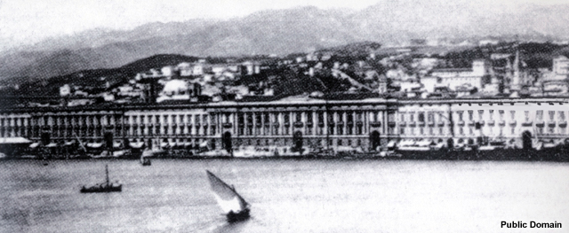
In 1908, one of Italy's strongest recorded earthquakes generated a massive underwater landslide in the Strait of Messina (Billi, et.al, 2008).
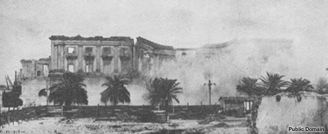
In most places the sea withdrew from the coast first. About eight minutes after the earthquake, three huge waves up to 10 feet (3 meters) high reached shore.
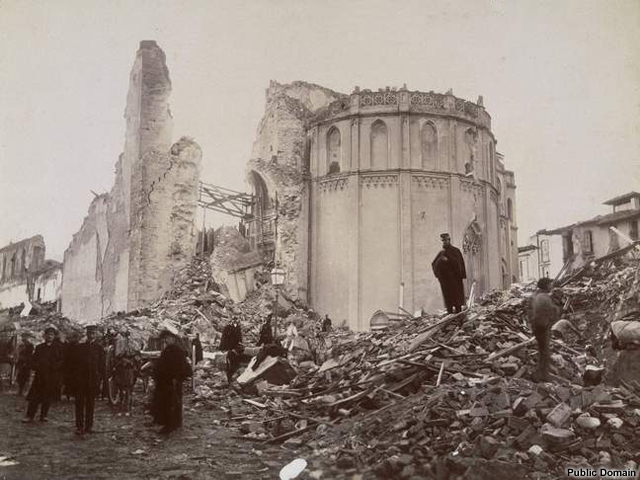
On the mainland, the strongest waves moved an iron bridge over 98 feet (30 meters) (Dickie. 2002) and completely destroyed Reggio Calabria.
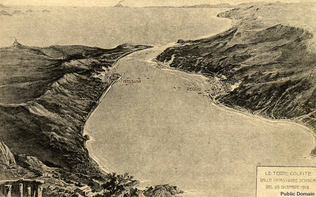
In Sicily, on the other side of the strait, the tsunami moved ashore without a warning retreat of water, carrying boats inland and destroying the Port of Messina. On both sides of the Strait, many buildings were swept away and many lives were lost (NGDC #2).
220 lives lost
Over $25,000,000 in damages
Japan 1933

A catastrophic tsunami rolled over Japan's Sanriku coast on March 2, 1933 following a moment magnitude 8.4 earthquake centered off the coast of Honshu.
It washed away 8,000 watercraft (NGDC #3) and nearly 3,000 homes (USGS) with waves up to 94 feet (28.7 meters) high.
Following the disaster, protective measures were implemented, including the creation of instructions for tsunami safety, town resettlements to higher locations, construction of a sea wall, a tsunami control forest, the designation of tsunami evacuation roads, and tsunami warnings issued over outdoor speakers (DCRC, 1999).
Over 3000 lives lost
Over $25,000,000 in damages
Pakistan 1945
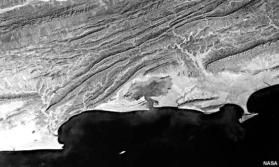
Satellite image of the Makran Coast and the Makran Coast Range
Scientists are still studying whether an earthquake or an undersea landslide triggered the disastrous 1945 Makran Coast tsunami in the Arabian Sea (Heidarzadeh, 2008).
Within 2-3 hours after a magnitude 8.3 earthquake hit (Bilham, nd), a large tsunami swept the entire Arabian Sea coast.
The tsunami was so powerful, that it was measured as far away as Karwar, India 1,000 miles (1,609 kilometers) from the earthquake’s epicenter. (NGDC #4).
300 lives lost
Over $5,000,000 in damages
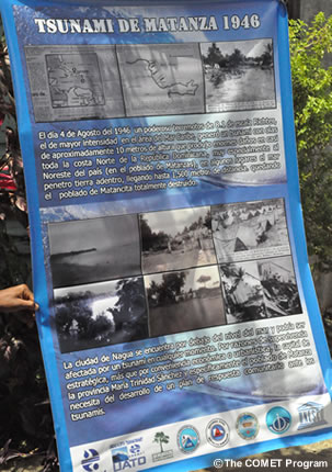
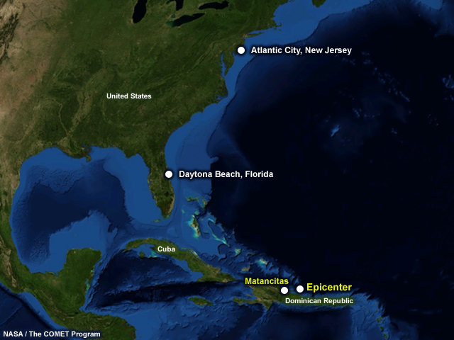
Dominican Republic 1946
On August 4, 1946, a magnitude 8.1 earthquake, centered at the Mona Passage east of the Dominican Republic, generated a tsunami that would devastate the country's northeast coast.
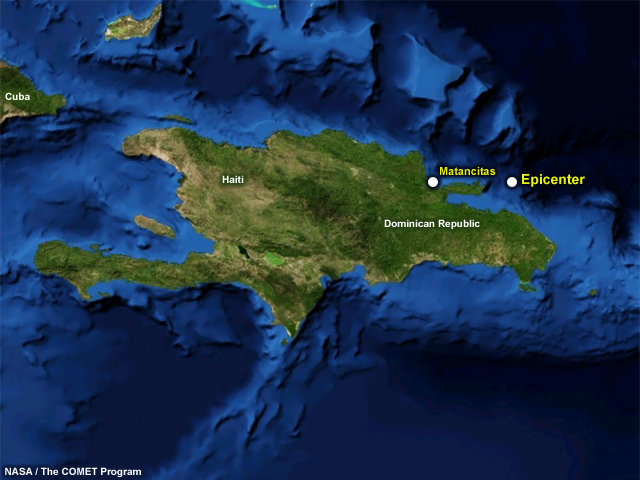
The 8 foot (2.5 meter) wave entered at Matancitas near Nagua and moved inland several kilometers (E. Calais), flattening houses and taking lives.
Tide gauges detected the tsunami at Daytona Beach, Florida and Atlantic City, New Jersey a few hours after the quake (NOAA).
1790 lives lost
Over $5,000,000 in damages
Alaska 1946
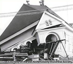
Scotch Cap
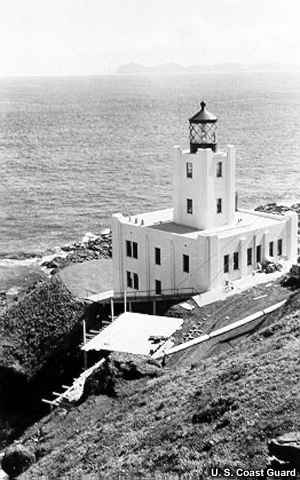
The newly built Scotch Cap Lighthouse in 1940
In 1940, the U.S. Coast Guard built a new lighthouse at Scotch Cap, nearly 100 feet (30 meters) above the ocean on cold, barren Unimak Island. The lighthouse, made with reinforced concrete, replaced an old wooden lighthouse.
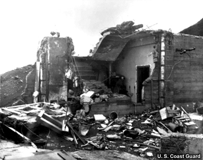
The Scotch Cap Lighthouse after a tsunami completely destroyed it in 1946
On April 1 1946, a 7.4 magnitude earthquake struck the Aleutian Trench It launched a tsunami that obliterated the Scotch Cap lighthouse just 48 minutes later.
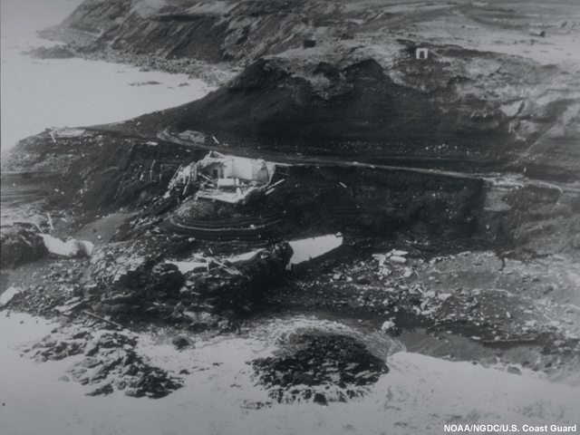
The Scotch Cap lighthouse is completely destroyed following the 1946 tsunami.
The destruction from this tsunami led the United States to develop the first tsunami travel time charts for the Pacific and create the Pacific Tsunami Warning Service.
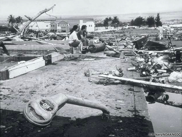
Hilo, Hawaii
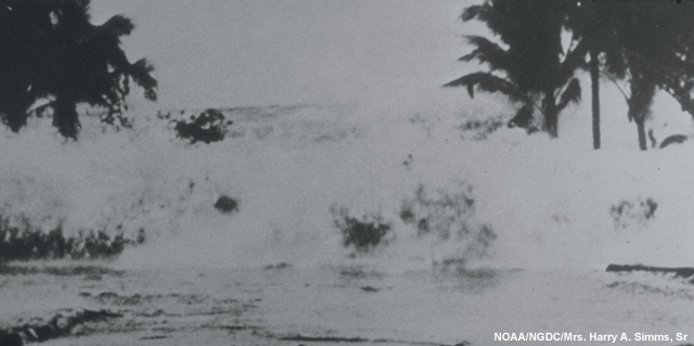
Less than 5 hours after the earthquake, a tsunami wave had traveled in the other direction to Hilo, Hawaii. The residents there were completely unaware the tsunami was coming that April Fools' Day morning.
When water in the Hilo bay drained, curious people went to the beach to see the exposed fish and turtles. Many people were caught in the waves that quickly followed the water's retreat.
The massive 26 foot high (8 meter) tsunami destroyed much of downtown Hilo.
165 total lives lost (all locations)
$26,000,000 total damages
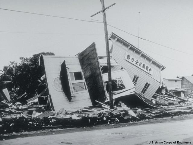
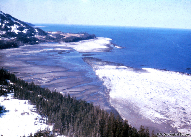
Chile 1960
The largest earthquake ever recorded occurred off the coast of Chile late on May 22, 1960.
For hours afterward, tsunami waves fanned out across the Pacific, pounding the coasts of Chile, Japan, and Hawaii.
In Chile, the land sank 5-7 feet (1-2 meters) in some areas, causing shores to permanently retreat inland.
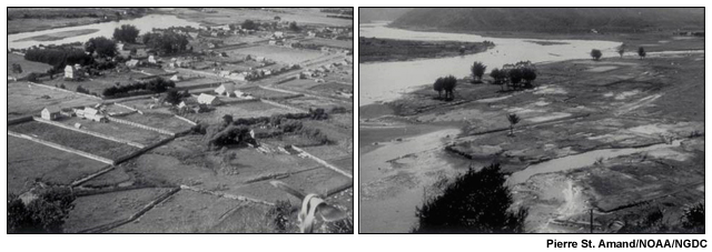
These images of the town of Queule before and after the tsunami show the scale of destruction; only a few trees dot the landscape. The 15-foot (4.5 meter) tsunami flowed inland, destroying fishing boats, homes, and towns in its path.
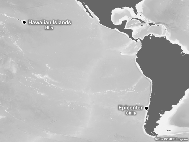
The tsunami traveled to Hilo, Hawaii, arriving 15 hours after the quake.
A zone of total destruction lay where businesses and residences had once stood in and around downtown Hilo.
1223 total lives lost (all locations)
$75,000,000 total damages
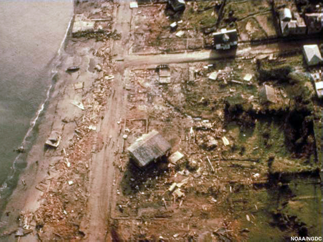
Alaska 1964
Prince William Sound
At 5:36 pm local time, on March 27, 1964, one of the largest earthquakes in North American history struck Prince William Sound, Alaska.
From the focus 14 miles (23 kilometers) beneath the earth's crust, a magnitude 9.2 earthquake violently shook the ground for nearly three minutes.
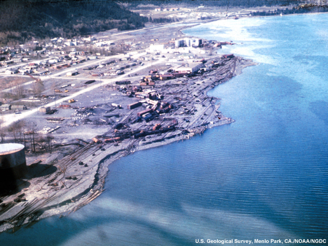
Valdez, AK

Already near low tide, the water in the Port of Valdez drained from the beaches. Suddenly much of the delta was exposed. Without water to support the upper sediment layers, gravity and the earthquake's shaking caused a collapse, an effect scientists call "spontaneous liquefaction."
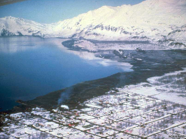
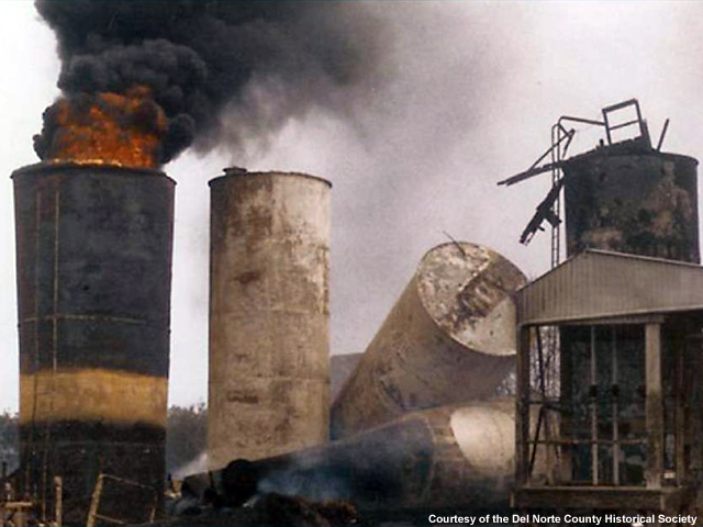
Just twenty seconds after the earthquake began, the large unstable section of water-saturated ground slid into the bay taking part of the town, 500 feet (152 meters) of the dock and the supporting delta with it. The sliding sediment pushed up a tsunami nearly 40 feet (12 meters) high when it reached the shore of Port Valdez.
The earthquake and the tsunami ruptured nearby oil tanks, which exploded into flames and burned for two weeks. Smaller waves from the earthquake-driven tsunami came hours after the local landslide-driven tsunami, but by then, the damage had been done (USC, n.d.)
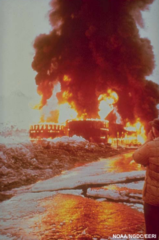
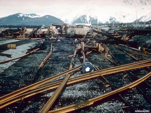
Seward, AK
In Seward, Alaska, two-thirds of a mile of a narrow section of waterfront slumped beneath Resurrection Bay.
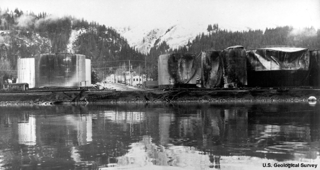
The slide generated a local tsunami that picked up fuel from ruptured oil tanks and spread it across the water. It soon caught fire.
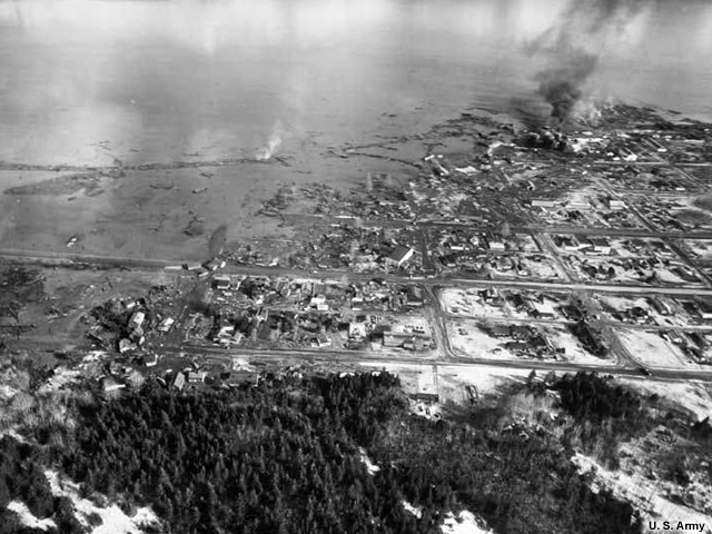
Twenty minutes later, the flaming oil was caught up in a 40-foot (12-meter) tsunami, setting fire to the nearby petroleum facilities.
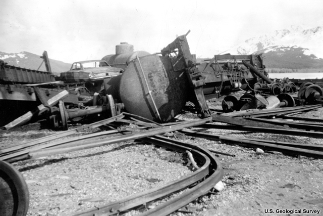
On the waterfront, the waves tossed a locomotive from its tracks and severely damaged the Alaska Railway terminus (NGDC).
Crescent City
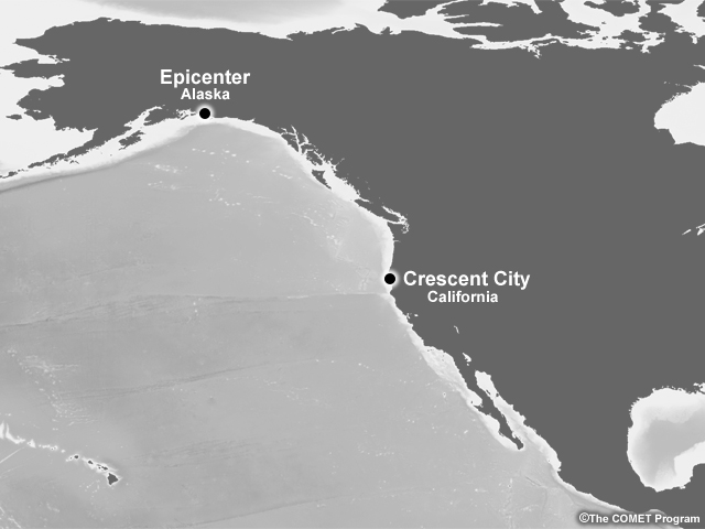
2,661 miles (4,282 kilometers) away in California, the first warning bulletin arrived at 11:08 pm. A second bulletin at 11:50pm warned a tsunami should arrive at Crescent City around 12:00 midnight. Authorities had only 10 minutes to alert residents (Anderson, 1970).
Port facilities and 29 city blocks were damaged or destroyed. The Crescent City tsunami waves were the most disastrous to strike the west coast in U.S. history.
124 total lives lost (all locations)
$124,000,000 total damages
Philippines 1976

Eighteen minutes after an 8.1 moment magnitude earthquake rocked the Celebes Sea between the Philippines and Borneo on August 17, 1976, the residents of Pagadian City, Philippines, were caught unaware by a 15-foot (4.6 meter) tsunami that washed inland.
The earthquake in the Moro Gulf produced a tsunami measured in at least 16 different locations (NGDC #5).
4456 lives lost
$130,000,000 in damages
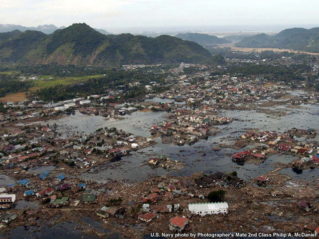
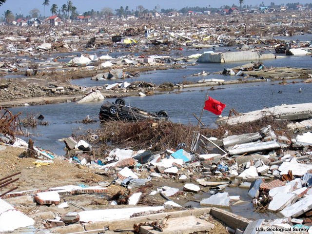
Indonesia 2004
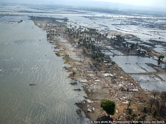
On December 26, 2004, a magnitude 9.0 earthquake struck the seabed off the coast of West Sumatra, Indonesia. It was the fourth largest recorded since 1900. The massive quake sent waves rippling across the globe.
Tsunamis were recorded from the Antarctic to Canada.
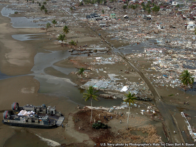
The unrelenting torrent of waves scoured the coastal areas of Indonesia, India, Sri Lanka, and Thailand.
The Simeulue Island in Indonesia's Aceh province experienced maximum wave heights of nearly 32 feet (10 meters) just 10 minutes after the earthquake's shaking stopped, yet few people were killed. The people of Simeule Island told oral histories of a tsunami event that occurred in 1907. The story tells the people to run to higher ground if the earth shakes for about 1 minute. All of the Simeule that survived knew the story well.
Far more casualties were suffered on the Aceh mainland, where the stories were unknown to the people (McAdoo, 2006)
Causing over 10 billion dollars in damages and 227,898 deaths, the event is by far the most devastating tsunami on record. (NGDS #6)
227,898 lives lost
Over $10,000,000,000 in damages
Samoa 2009
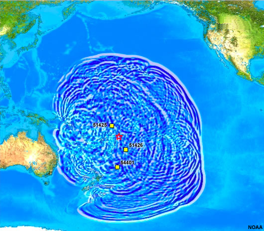
Where the subducting Pacific Plate and the Australian Plate meet at the Tonga Trench, a moment magnitude 8.0 earthquake ruptured the ocean floor on September 29, 2009.
The resulting tsunami arrived at Pago Pago, American Samoa, just 11 minutes after the quake.
Radios immediately warned residents to flee to higher ground.
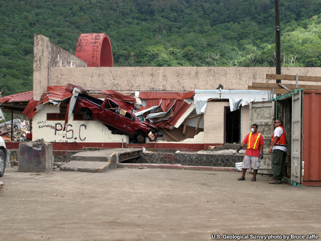
The waves were so strong that they twisted concrete beams and mangled cars.
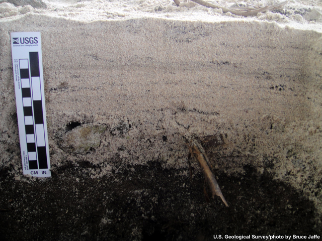
Sand blankets the darker soil that existed before the 2009 tsunami at Alao.
Survivors from Tonga, Samoa, and American Samoa saw entire villages disappear beneath the water. (NGDC #7)
Those who fled stayed safely on a mountain until the all clear was given hours later.
192 lives lost
Over $5,000,000 in damages
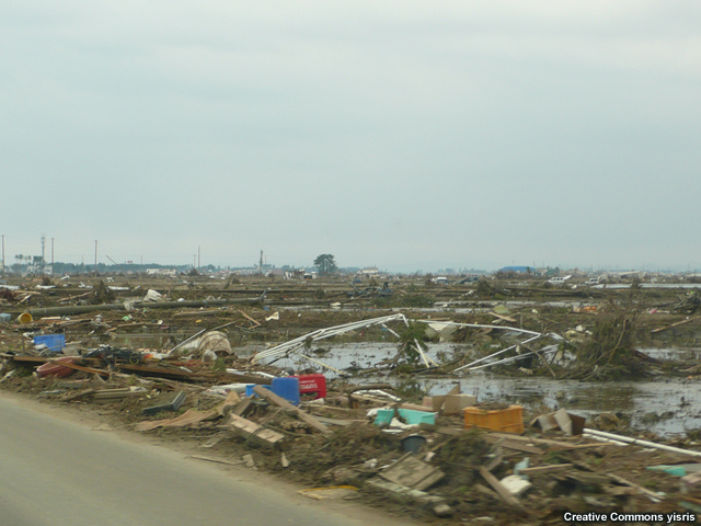
Japan 2011
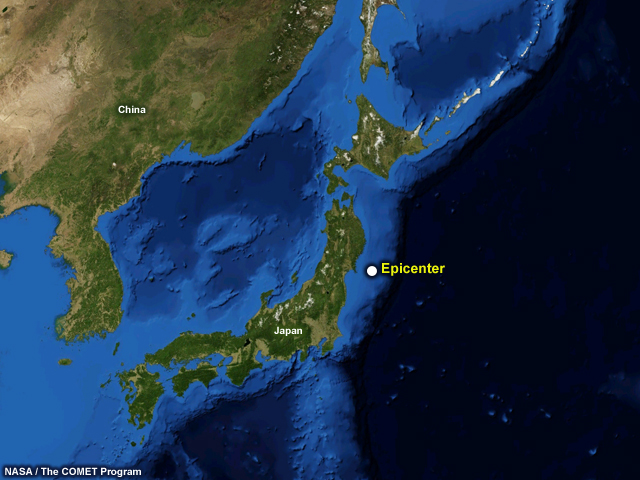
On March 11, 2011 off the northeastern coast of Honshu Island, Japan, the largest earthquake and tsunami in the history of the country struck.
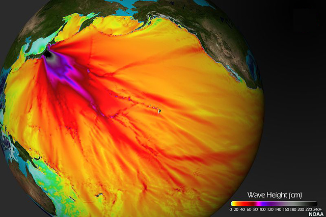
The earthquake, magnitude 9.0, moved Honshu 7.9 feet (2.4 meters) east. It was the fourth most powerful earthquake on record.
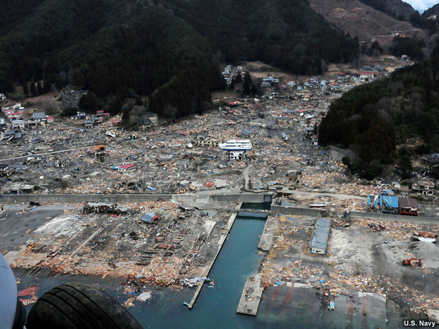
Though the waves measured a few dozen feet high in most places they came ashore, they climbed as far as 124 feet (or almost 38 meters) high in some places and traveled as far as 6 miles (10 kilometers) inland.
Thousands died, some because of the extreme height of the waves compared to warnings.
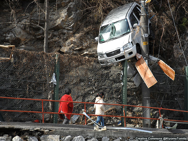
The greatest predicted height was 33 feet (10 meters), while waves climbed double or triple that high in some places. Many people caught in the tsunami had climbed to heights they thought were safe.

Though many cities had tsunami walls, the tsunamis simply spilled over them.
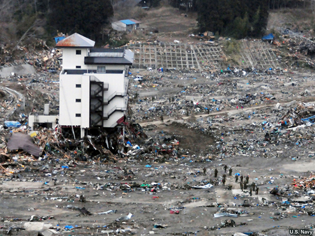
In some places, three-story-high waves swept away entire towns.
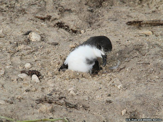
The tsunami had dire effects elsewhere, too. In the middle of the Pacific, a 5-foot (1.5-meter) wave engulfed Midway Atoll's reef inlets and Spit Island. More than 110,000 nesting seabirds died as a result at the Midway Atoll National Wildlife Refuge, but not this one. Though trapped in sand by tsunami waves, it was freed by a U.S. Fish and Wildlife Service employee after this picture was taken.
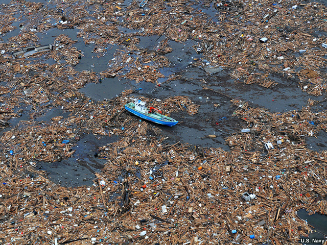
In the end, officials estimated the tsunami claimed about 20,000 lives, and damaged or destroyed over 125,000 buildings. The World Bank and the government of Japan estimate the losses in the hundreds of billions of dollars.
~20,000 total lives lost (all locations)
$122,000,000,000-$390,000,000,000 total
damages
References
Anderson, W.A. Tsunami Warning in Crescent City, California and Hilo, Hawaii. The Ohio State University, 1970
Billham, cited 2010. [Available online from http://cires.colorado.edu/~bilham/Makran1945/MakranTsunami.html]
Billi, et al (AGU), cited 2010: On the cause of the 1908 Messina tsunami, southern Italy. [Available online from http://www.agu.org/pubs/crossref/2008/2008GL033251.shtml ]
Calais, E., J. Perrot and B. Mercier de Lépinay. 1995: From Cuba to Hispaniola
Strike-slip tectonics and seismicity along the northern Caribbean plate boundary.
DCRC, cited 2010: Tsunami disasters and countermeasures in Japan , 20th century. [Available online from http://www.tsunami.civil.tohoku.ac.jp/hokusai2/topics/counter.html ]
Dickie, J., J. Foot, F. Snowden. 2002: Disastro! Disasters in Italy since 1860: Culture, Politics, Society Palgrave 239 pp.
Dudley, W. and M. Lee. 1998. Tsunami! University of Hawaii press: Honolulu
Heidarzadeh, M., M. Pirooz,, N. Zaker, A. Yalciner, M. Mokhtari, A. Esmaeily. 2008: Historical tsunami in the Makran subduction zone off the southern coasts of Iran and Pakistan and results of numerical modeling. Ocean Engineering, 35, 774-786. [Available online from https://www.sciencedirect.com/science/article/abs/pii/S0029801808000371?via%3Dihub ]
McAdoo, B., L. Dengler, G. Prasetya, V. Titov. 2006: Smong: How an oral history saved thousands on Indonesia's Simeulue Island during the December 2004 and March 2005 tsunamis. Earthquake Spectra , 22, S661-S669 [Available online from: http://scitation.aip.org/getabs/servlet/GetabsServlet?prog=normal&id=EASPEF0000220000S300S661000001&idtype=cvips&gifs=yes&ref=no ]
NGDC (#1), cited 2010: Earthquake damage to transportation systems. [Available online from http://www.ngdc.noaa.gov/nndc/servlet/ShowDatasets?EQ_0=87&bt_0=&st_0=&EQ_1=&bt_1=&st_1=&query=&dataset=101634&search_look=2&group_id=null&display_look=4,44&submit_all=Select+Data ]
NGDC (#2), cited 2010: Tsunami event . [Available online from http://www.ngdc.noaa.gov/nndc/struts/results?EQ_0=1373&t=101650&s=9&d=99,91,95,93&nd=display]
NGDC (#3), cited 2010: Tsunami event. [Available online from http://www.ngdc.noaa.gov/nndc/struts/results?EQ_0=1661&t=101650&s=9&d=99,91,95,93&nd=display]
NGDC (#4), cited 2010: Tsunami event. [Available online from http://www.ngdc.noaa.gov/nndc/struts/results?EQ_0=1761&t=101650&s=9&d=99,91,95,93&nd=display]
NGDC (#5), cited 2010: Tsunami event. [Available online from http://www.ngdc.noaa.gov/nndc/struts/results?EQ_0=2086&t=101650&s=9&d=99,91,95,93&nd=display]
NGDC (#6), cited 2010: Tsunami event. [Available online from http://www.ngdc.noaa.gov/nndc/struts/results?EQ_0=2439&t=101650&s=9&d=99,91,95,93&nd=display]
NGDC (#7), cited 2010: Tsunami event [Available online from http://www.ngdc.noaa.gov/nndc/struts/results?EQ_0=4440&t=101650&s=9&d=99,91,95,93&nd=display
USC Tsunami Research Group, cited 2010: The 1964 tsunami strikes Valdez. [Available online from http://www.usc.edu/dept/tsunamis/alaska/1964/webpages/1964valdez.html ]
USGS, cited 2010: Historic earthquakes: Sanriku Japan. [Available online from http://earthquake.usgs.gov/earthquakes/world/events/1933_03_02.php ]
Marine Geophysical Researches, 17, 63-95
NOAA, cited 2010: Tsunami tidal waves and other extreme waves. [Available online from http://www.erh.noaa.gov/phi/reports/tsunami.htm ]
Click here to return to the 6+ Hours Page.