Produced by The COMET® Program
Case Profile and Introduction
This case occurred over Puerto Rico on 6-7 May 2001. It illustrates synoptic scale forcing of an upper level trough, orographic forcing, and severe weather with the development of squall lines and bow echos. Related weather hazards included heavy rain, high winds and flooding. The aviation impacts of each are explored at the end of the case.
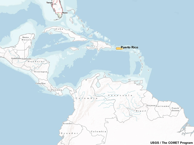
Fig. 1. Puerto Rico is an island in the northeastern Caribbean.
Local Topography and Climatology
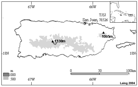
Fig. 2. Topography of Puerto Rico showing elevations above 500 m (light gray) and above 1000 m (darker gray).
This case takes place at the beginning of the wet season, which normally occurs between May and November. The topography of Puerto Rico greatly influences the amount and distribution of precipitation over the island. The normal annual amount of precipitation varies from 30 inches (76 cm) along the southern coastal plain to almost 100 inches (250 cm) over the La Cordillera Central mountain range near the center of the island. The northeastern Sierra de Luquilllo mountain range normally receives the greatest amount of precipitation annually (172 inches or 440 cm), which is seen as a bull's eye in the eastern part of the island.
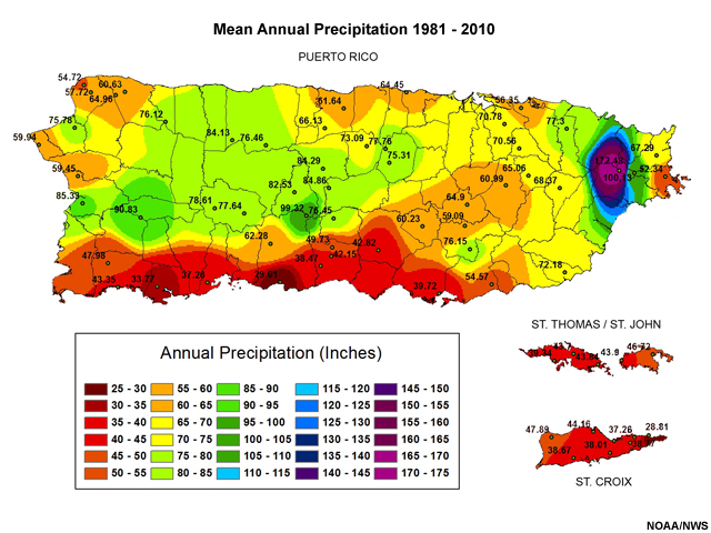
Fig. 3. Mean annual precipitation in inches over Puerto Rico and nearby islands for the period of 1981-2010.
Conceptual Models
Orographic Forcing
Orographic forcing describes the effect terrain has when air flows up the slope of a mountain. Lift of air parcels in an unstable atmosphere will be enhanced as they are forced upslope. This enhanced lift can result in clouds of greater vertical development and areas of heavier precipitation.
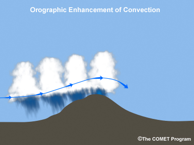
Fig. 4. Flow over terrain can enhance convective lift.
Squall Lines
Squall lines are a type of mesoscale convective system. A squall line appears as a line of convective cells that is significantly longer than it is wide.
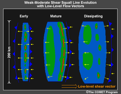
Fig. 5. Life cycle of a squall line.
In a weak to moderately sheared environment such as in the tropics, a squall line begins as a line of convective cells. As it matures, the leading edge strengthens into a more solid line of strong cells with an area of stratiform precipitation extending behind it. A narrow region of very light precipitation, referred to as a weak echo channel or transition zone, often occurs between the leading line of convection and the trailing stratiform precipitation region. During the dissipating stage, the leading convection weakens, but the trailing stratiform precipitation can persist for several hours.
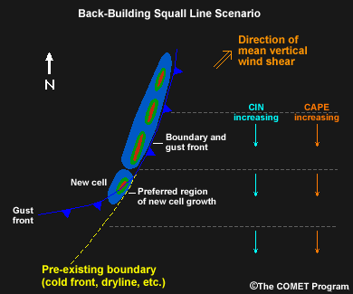
Fig. 6. Conceptual model of a back-building squall line.
Bow Echoes
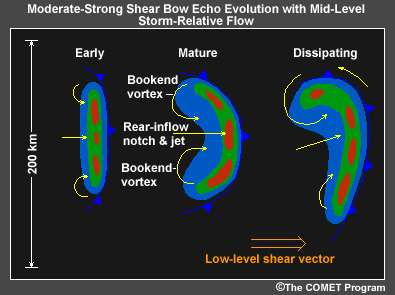
Fig. 7. Life cycle of a bow echo.
A bow echo is another type of mesoscale convective system that can evolve from a squall line. This conceptual model shows a weak echo area behind the core of the bow, referred to as a "rear-inflow notch" (RIN). This notch often signifies the location of a strong rear-inflow jet that can descend to the surface bringing extremely strong winds. These strong winds give the bowed shape to the reflectivity signature.
Case Challenge
- Correlate radar signatures to orographic forcing and development of squall lines and bow echos.
- Identify areas subjected to prolonged or redeveloping convective rainfall.
- Describe potential impacts of mesoscale convective complexes and heavy precipitation on aviation operations.
Synoptic Scale Features
The upper level wind field is presented in the image of 200 hPa streamlines from 0000 UTC on 6 May 2001.
Question 1 of 2
Describe the synoptic-scale pattern affecting Puerto Rico.
(Choose the best
answer.)
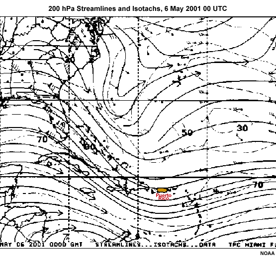
Fig. 8. 200 hPa streamline analysis at 0000 UTC on 6 May 2001.
The correct answer is d).
The longwave trough over the Atlantic extends into the Caribbean. Embedded in this pattern is a shortwave trough just to the west of Puerto Rico.
Question 2 of 2
How is the upper level trough reflected in the satellite and radar data around 14 UTC
on 6 May 2001?
(Choose the best answer.)
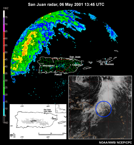
Fig. 9. Radar reflectivity at 1345 UTC on 6 May 2001 from San Juan NWS Doppler Radar. Right inset shows the corresponding visible image with the radar range outlined in blue. Left inset shows Puerto Rico with elevation above 500 m shaded.
The correct answer is b).
The trough identified to the west of Puerto Rico in the streamline analysis is reflected as a broad area of multilayered clouds in the satellite imagery and as an area of precipitation approaching Puerto Rico. Convective activity and a broad area of clouds and precipitation can be expected to affect the region in the next few hours.
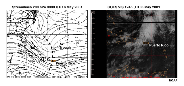
Fig. 10. 200 hPa streamline analysis showing an upper level trough at 0000 UTC 6 May and the visible satellite images at 1245 UTC 6 May 2001.
Mesoscale Features
Fig. 11. Animation of radar reflectivity from San Juan, Puerto Rico radar from 07:58 UTC on 6 May to 01:59 UTC on 7 May 2001.
Examine the radar data loop and answer the following questions:
Question 1 of 5
Why does convection develop in the central part of the island early in the loop?
(Choose the best answer.)
The correct answer is c).
In early stages on the radar image, convection develops over the higher elevations as air is lifted up the mountain slopes and clouds form.
Question 2 of 5
Later in the loop, how does the topography influence the character of the
precipitation?
(Choose the best answer.)
The correct answer is a).
As the squall line moves into the higher terrain, regions of convection over the mountains show more widespread areas of higher reflectivity. Convection associated with the squall line is enhanced by topographic forcing.
Question 3 of 5
As the large precipitation band moves closer to Puerto Rico, the heavy precipitation
line breaks into smaller multi-cellular structures. How would you classify the
mesoscale convective systems that are present at 1700 UTC?
(Choose the best
answer.)
The correct answer is b).
By 1700 UTC, the line has two bow echoes along the west coast, critical features to monitor because they can produce swaths of damaging, straight-line surface winds.
Question 4 of 5
How do the orientation, movement, and topographic characteristics affect the amount
of precipitation falling in the southwestern portion of the island?
(Select all
that apply.)
The correct answers are a), b) and c).
From 1800 to 2200 UTC, the heaviest precipitation is oriented almost west to east with new cells forming to the west and moving along a similar track as older cells. Animation of the radar images also shows bands of precipitation to the north of the island oriented from SE to NW and moving towards the northeast.
Question 5 of 5
What is forcing the development ahead of the main area of convection at 2300 UTC?
(Choose the best answer.)
The correct answer is b).
Radar indicates a new line of cells is forming along the outflow boundaries moving ahead of the main convection.
Assessing Impacts
The impact on aviation due to conditions experienced on this day includes decreases in the Airport Acceptance Rate (AAR), which determines the number of aircraft that can land at a specific airport in a given time frame. The maximum AAR depends on the runway availability and whether aircraft are making visual or instrument approaches. The most common reasons for a reduction in acceptance rate include adverse weather such as unfavorable winds, low ceilings and low visibility.
Question 1 of 2
An approaching bow echo in the tropics brings what type of aviation hazards?
(Select all that apply.)
The correct answers are a), b), c) and e).
Bow echos are associated with very strong straight-line winds. Depending on the orientation of the winds to the runways, these winds can pose wind shear as well as crosswind hazards. Both of these hazards can affect AAR, and in the case of crosswinds, runways could be shut down. The presence of low level wind shear can stop takeoffs and landings until the hazard has past. Turbulence associated with these winds and convection can also decrease the AAR and cause flight delays. Low visibility associated with heavy rain also causes decreased AAR as pilots might have to change from visual to instrument approaches. The end result of a bow echo moving over an airport is greater hazards to approaching aircraft, resulting in a greater spacing of landing aircraft and flight delays.
Question 2 of 2
Heavy rain continued to fall over the southwestern part of the island as new cells
within the squall line formed and moved along a similar track as older cells. With
this prolonged heavy rain event, how could aviation operations have been impacted?
(Select all that apply.)
The correct answers are a), b) and c).
Rain can significantly impact aviation operations by affecting breaking action of landing aircraft. When runways are wet, aircraft need to use either a longer runway or slower speed to ensure a safe landing, and aircraft must be spaced farther apart for landing to allow for this, which lowers the airport's AAR. Aircraft must land via an Instrument Flight Rules (IFR) approach when ceilings or visibilities are below Visual Flight Rules (VFR) conditions. An IFR approach spaces the aircraft farther apart as they land via an Instrument Landing System (ILS). Not all runways at an airport are ILS-equipped, which further reduces the AAR. When visibilities fall below a mile, the AAR may decrease to critical values, and the airport may even close. Low ceilings and visibility can also impact ground operations, such as taxiing and even ramp operations.
Summary
This case provided examples of a variety of aviation hazards imposed by mesoscale convective systems, upper level troughs and orographic forcing. The system approaching Puerto Rico early on May 6th developed with the synoptic forcing of the upper level trough located upstream. Mesoscale convective systems formed within this system bringing heavy rain and strong winds to the area. Radar data showed the presence of a squall line, bow echos and the influence of topography on the precipitation patterns.

Fig. 12. Summary of major weather features seen on radar reflectivity during the storm event.
Heaviest rain was observed over the southwestern part of the island where convective cells continued to form to the west and moved along a similar track as older cells.
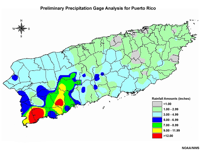
Fig. 13. Preliminary 24-hr precipitation analysis for the storm.
This event had a huge impact on the public with major flooding in western, southwestern and the western interior of Puerto Rico. Two people died and there was over $150 million in damage. Forecasting and warning efforts were hampered by the fact that the Storm Total Precipitation Estimates from Doppler Radar data underestimated the rainfall by up to 66% in some areas.
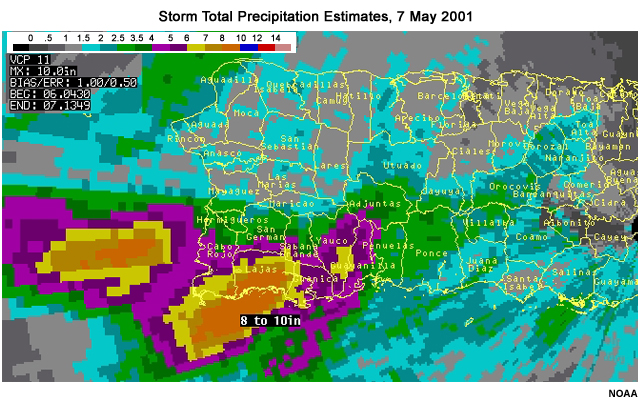
Fig. 14. Storm Total Precipitation Estimates from Doppler Radar for 7 May 2001.
References
- Laing, A. G., 2004: Cases of Heavy Precipitation and Flash Floods in the Caribbean during El Niño Winters. J. Hydromet, 5, 577-594.
- NWS San Juan, Preliminary Report on the Floods over Puerto Rico May 6-7 2001
http://www.srh.noaa.gov/sju/?n=2001_flood03 - Santos et al., Vulnerability to disasters in Puerto Rico: Incorporating the social, physical
and built environment to radar scanning strategies.
https://ams.confex.com/ams/87ANNUAL/techprogram/paper_119787.htm - Review of case in COMET’s Tropical Textbook:
http://www.meted.ucar.edu/tropical/textbook_2nd_edition/navmenu.php?tab=10&page=3.5.2
and
http://www.meted.ucar.edu/tropical/textbook_2nd_edition/print_9.htm - Aviation impacts due to weather
http://sciencepolicy.colorado.edu/socasp/weather1/qualley.html
and
http://www.meted.ucar.edu/nas/print3.htm - Common Tropical Synoptic-scale Systems
http://www.meted.ucar.edu/tropical/textbook_2nd_edition/navmenu.php?tab=10&page=3.4.1 - System Motion and Back Building
https://www.meted.ucar.edu/mesoprim/severe2/navmenu.php?tab=1&page=3-5-4&type=flash