Feature Identification Exercises
Print Version
Case Example 1: Manitoba
Manitoba Imagery

Page 1: Introduction
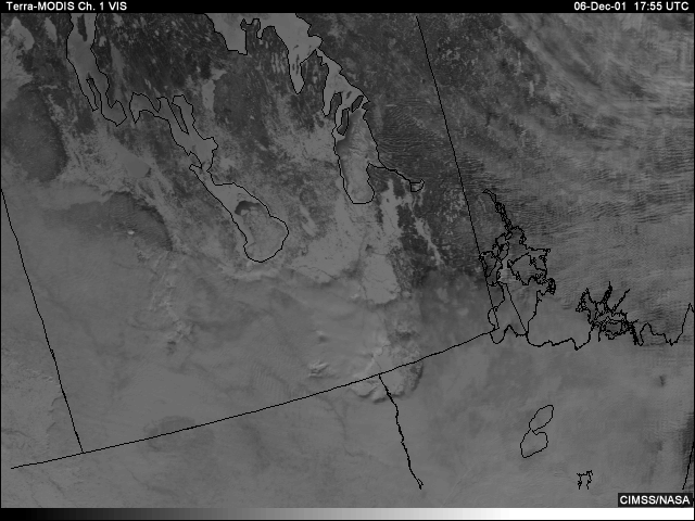
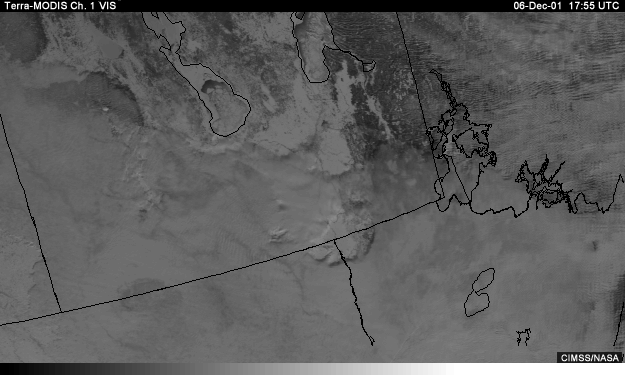
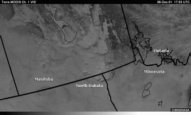
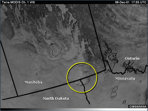
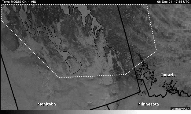
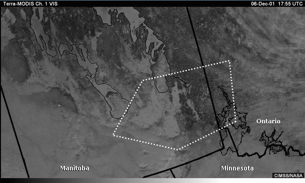
This visible image is from MODIS on the Terra satellite. It shows a typical wintertime scene of snow and ice interspersed with clouds over portions of North Dakota, northern Minnesota, southern Manitoba, and southwestern Ontario, Canada.
To the trained eye, shadows, reflective cloud edges and texture seem to indicate the presence of some form of cloudiness along the Manitoba-U.S. border. The relatively smooth appearance of the scene hints at a cloud deck whose coverage may be quite extensive. But then again, surface features remain obvious at many locations. The absence of clearly defined cloud boundaries really complicates the process of identifying cloud and surface features.
Page 2: Channel Selection: Separating Clouds and Surface Features
Which channel or combination of channels best distinguishes between clouds and surface features and snow across southern Manitoba?
visible
1.6 micrometers
3.9 micrometers
11 micrometers
Answer:
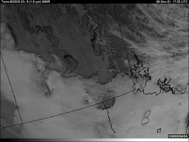
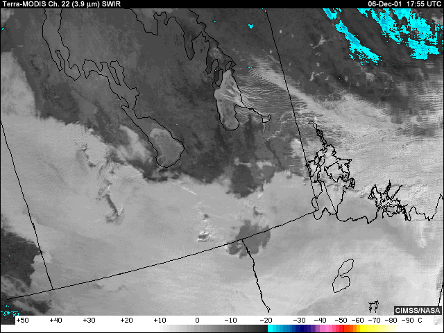
For this scene, low clouds and most cirrus appear brighter and are easily separated from the darker, less reflective underlying snow and ice cover in the 1.6-micrometer channel. Very thin cirrus, such as that seen across western Ontario, may become more difficult to discriminate. The 3.9/11-micrometer combination is plausible, but not correct. Ice clouds, snow, and ice cover are all poorly reflective and may take on a relatively dark (cold) appearance at 3.9 micrometers. Low clouds and some open bodies of water may also be difficult to distinguish from one another, since both may appear warm at 3.9 micrometers. The 11-micrometer channel is incorrect since low clouds and surface features are difficult to distinguish at 11 micrometers for what is a relatively cold scene. The visible/1.6-micrometer combination is plausible, but not correct. The visible channel does poorly in separating clouds, snow, and ice, as all are highly reflective in the visible.
Page 3: Channel Selection: Separating Ice Cover and Open Water
Which channel or combination of channels would be optimal for separating ice cover from open water on known rivers and lakes?
Answer:
The combination of visible and 1.6-micrometer shortwave IR imagery would be the most helpful in this case. In the absence of any clouds, dust, haze, or sun glint, the visible channel is best at picking up the contrast between ice and open water. Some warmer open water and rivers are seen in Manitoba and western Ontario, and the longwave infrared is very good at highlighting the cold high cirrus over Ontario. If dust, haze, or sun glint are present, however, the 11-micrometer channel will help to confirm temperature differences associated with ice and open water.
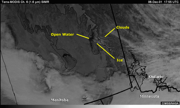
The presence of any clouds over the water and ice surfaces can be confirmed with the help of 1.6-micrometer imagery.
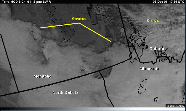
Page 4: Identification Task: Cloud over Snow
Using the available channels, look along the Manitoba-U.S. border and identify an area of cloud over snow.
Hint:
Use visible and 1.6-micrometer channel to help you distinguish clouds from snow.
Answer:
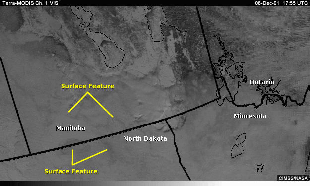
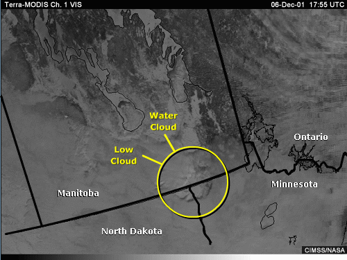
The visible channel image is telling us we have clouds, snow cover, or a combination of both. It even looks like surface features are partially visible hinting at perhaps a thin cloud deck.
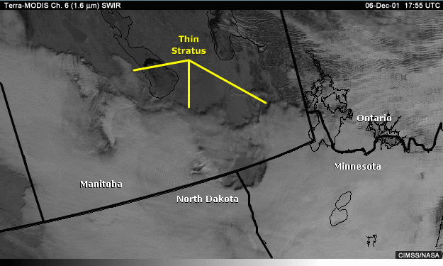
Using the 1.6-micrometer channel, we are able to confirm that the smoother looking areas are indeed a low cloud deck of what must be thin stratus. Thin low-level stratus is common at higher latitudes during wintertime, posing one of the greatest risks to aviation and a challenging detection problem.
Page 5: Identification Task: Low or High Clouds
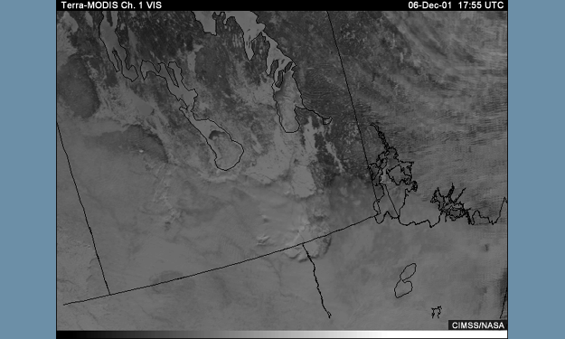
How would you describe the clouds in the area circled on the visible image? Identify cloud height (high/middle/low) and cloud type (water/ice).
Answer:
Clouds cover large portions of the lower half of the image and appear to be relatively thin, low-level stratus composed mainly of water droplets.
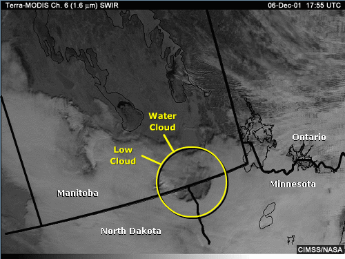
The presence of cloud cover is best confirmed using the 1.6-micrometer image when available. Clouds appear relatively bright, surfaces relatively dark.
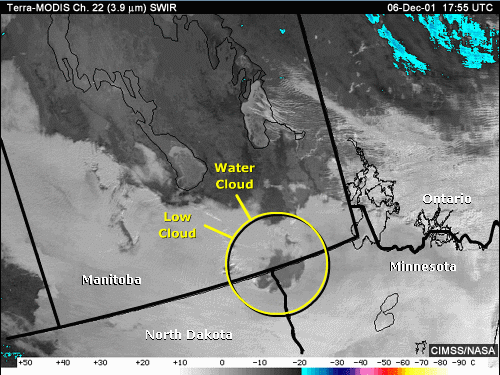
The 3.9-micrometer image helps in the determination of cloud phase. Brighter (warmer), more reflective cloud tops as seen here are indicative of water drops, whereas cloud ice would appear darker (colder) and poorly reflective.
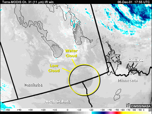
Looking at cloud-top brightness temperatures in the 11-micrometer image can help determine cloud height. For this cloud deck, brightness temperatures are within a few degrees Celsius compared to nearby ground, which is more evidence that these are indeed low-level clouds.
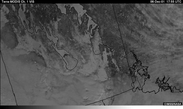
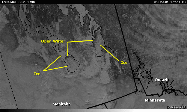
Page 6: Identification Task: Find Unmarked Lakes
Hints:
Best located using visible, 1.6-, 3.9-, and/or 11-micrometer channels.
If the surface appears bright in the visible, this implies frozen surface or cloud. The properties of the shortwave infrared channels should then help you discriminate between cloud, snow, and ice.
If the surface appears relatively dark, use then either 3.9 or 11 micrometers to help confirm the presence of open water, seen as a hot spot relative to surrounding areas and effective for colder wintertime scenes.
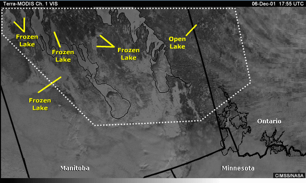
Answer:
Ice-covered lakes appear relatively bright in the visible image implying we have either snow or ice
cover.
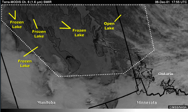
The 1.6-micrometer image helps to highlight some outlines to these features, hinting at perhaps ice-covered lakes. Ice tends to appear somewhat darker in this channel.
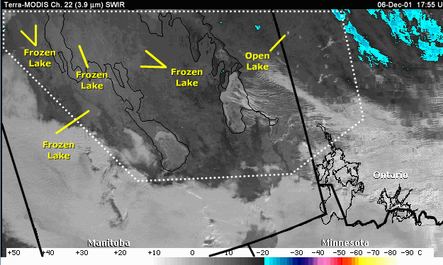
The 3.9-micrometer image is somewhat better at discriminating between ice and snow cover. Here, the features in question appear brighter than nearby snow cover, and we know from the visible that the lake-like features are covered by either snow or ice. The presence of ice cover is confirmed by looking at nearby lakes that are only partially frozen. Notice that the brighter/warmer portions of these lakes are associated with open water. The frozen portions of these lakes appear very similar to the surfaces of the two ice-covered lakes in question.
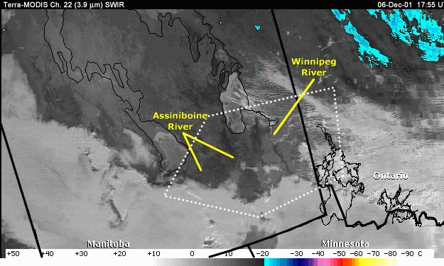
Page 7: Identification Task: Find Unmarked Lakes
Can you find any unfrozen rivers in the indicated area that may not be indicated by the map overlay?
Hints:
In the visible imagery look for river-like features; help determine whether surface may be frozen (relatively bright/reflective) or open water (relatively dark/poorly reflective).Use the 1.6-micrometer channel to help confirm presence of river-like features and open water (poorly reflective/dark in this channel).
Use the 3.9- and 11-micrometer channels to help locate potential hot spots that may indicate the presence of
open water in colder atmospheric conditions.
Answer:
Because we are dealing with a relatively cold scene, looking for open water is
best accomplished with either the 3.9- or 11-micrometer infrared channels.
The 3.9-micrometer channel
will provide the best contrast between warm and cold because of its sensitivity to sub-pixel hot spots. In the
3.9 image, we see a relatively bright/warm, river-like feature in southeastern Manitoba. But because low water
clouds also appear bright/warm in this channel, we need additional confirmation. Looking at either the visible
or 1.6-micrometer channel confirms that these features appear relatively dark and are therefore likely not to
be ice covered. Recall that open water is poorly reflective in both the visible and 1.6-micrometer channels.
Page 8: Manitoba Summary
· The 1.6-micrometer channel is best for distinguishing
most cloud types, except for very thin cirrus.
Clouds appear brighter and are easily separated from the
darker, less reflective underlying snow and ice cover.
· Identifying low-level stratus, typical at higher latitudes
in wintertime, is best accomplished using the
1.6-micrometer channel
· The visible and 1.6-micrometer channels are an effective
combination in separating ice from open water.
Open water is poorly reflective/dark compared with and
other surfaces types in these two channels.
· For cold scenes, the 3.9- and 11-micrometer channels can
help detect therelatively warmer surface water associated
with open rivers where the visible channel may be difficulty
distinguishing between water and bare ground
or nearby forests
· Cloud type can be assessed with a combination of shortwave
and longwaveinfrared imagery. 3.9-micrometer imagery is
useful for determining cloudphase, and cloud height can be
inferred from 11-micrometer cloud-top
brightness temperatures.
· Identifying unmarked frozen lakes is best accomplished
with a combinationof visible, 1.6-, and 3.9-micrometer
imagery
· Visible imagery helps confirm cloud or frozen surface and
possible lake outlines
· 1.6-micrometer imagery helps distinguish between
snow, ice, clouds, and possible lake outlines
· 3.9-micrometer imagery helps distinguish between
ice and snow cover