Supporting Topics
Reference Maps
- Maps
- Met References
Barrier Jets
- Conceptual Model
- Thermodynamic Impacts
- Historical Studies
Reference Maps
Maps
- Map of U.S. (CONUS)
-

- Map of Central Rockies of U.S. with Topography
-

- Map of Northeastern Colorado with Topography
-

- Map of Boulder/Longmont Area with Topography
-

Met References
- Regional Cool Season Rules of Thumb
-
Here’s an objective list of simple forecaster aids, or rules of thumb, based on decades of snow forecasting in the region:
- Rain vs. snow: The threshold 1000-500 hPa thickness value is about 550 dam. During the spring and early fall this value is a bit lower.
- Northerly surges and cold fronts: Cold air tends to rush southward along the Front Range faster than the models predict. This has to do with smoothing of terrain within the models and inadequte low-level resolution.
- Upslope flow and heavy snow: Heavy snow events that are not primarily forced by convection require relatively deep low-level easterly or upslope flow, ie. depth extending upwards past 700 hPa.
- Northeasterly vs.southeasterly flow: Northeast surface winds tend to favor the north slope of the Palmer Divide in terms of snowfall, while southeasterly winds (though less frequent) favor the south slopes of the Cheyenne Ridge.
- Deep upslope flow: While 700 hPa flow is easterly during deep upslope events, below that level the winds typically are northerly and can be strong. This is a relatively favorable snowfall situation for the Front Range.
- Thickness Thresholds for Rain and Snow Boundary
-
Thresholds have been collected for key layer thicknesses and precipitation types. Assessing these can help determine the location of precipitation type boundaries. The following table presents the rules of thumb for determining the rain/snow boundary at sea level in a non-marine environment in North America. For the given layers, areas to the cold side of the corresponding thickness are likely to be producing snow.
At a higher elevation these threshold thicknesses need to be adjusted upward than those shown in the table. This adjustment needs to be greater as the surface elevation increases. In a marine environment, generally the threshold thicknesses are slightly lower due to the marine influence on low-level temperatures.
Thicknesses generally corresponding to the location of a rain/snow boundary in a non-marine environment in North America Layer (hPa) Thickness (m) 1000-500 5400 1000-700 2840 ( ± 20) 1000-850 1290 850-700 1540 850-500 4100 700-500 2560
- Conveyor Belt/TROWAL
-
For more detailed information on conveyor belts and the TROWAL, please see the COMET module:
Mesoscale Banded Precipitation and launch the section titled: Synoptic Setting: Conveyor Belts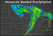
- Isentropic Analysis
-
For more detailed information on Isentropic Analysis, please see the COMET module:
Isentropic Analysis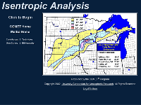
- Flow Interaction with Topography
-
For more detailed information on how flow interacts with topography, please see the COMET module:
Flow Interaction with Topography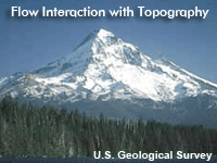
Barrier Jets
Conceptual Model
- Overview
-
The barrier jet is a low-level, barrier-parallel core of locally strong winds composed primarily of ageostrophic flow. The core of strong winds is typically located above the surface but in the lowest 1 km of the atmosphere.
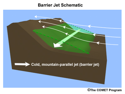
- Development
-
Barrier jets form as a result of the blocking of upslope flow by the terrain.* The primary cause is a geostrophic adjustment as a stable air mass becomes dammed up against a terrain barrier. A barrier jet can develop if:
- the blocking process is strong;
- the barrier is extended in a direction perpendicular to the unblocked flow upstream;
- the Froude number for the surface flow is relatively low (less than ~1)
If the stable air mass persists for several hours, air within it begins to move towards lower pressure. In easterly flow situations in the northern hemisphere, this acceleration becomes significant if the stable air mass is being replenished by low-level cold air, which is provided by cold advection, upslope flow, diabatic processes (melting or evaporation), or a combination of these three sources. In a westerly flow situation (in the Northern Hemisphere), the geostrophic adjustment causes southerly flow, which is typically warm air.
In the Northern Hemisphere, barrier jets that form as a result of easterly flow impinging upon a barrier are composed of northerly winds (e.g., the east slope of the Rocky Mountains). Those that form as a result of westerly flow impinging on a barrier are composed of southerly winds (e.g., upstream of the Sierra Nevada).
Of critical importance is the nature of the mid-level flow, i.e., its stability and moisture content. This air may be forced up and over the barrier jet, resulting in condensation and precipitation into the barrier jet. If this air mass is conditionally unstable, convection may be induced by the barrier jet due to forced upward motion.
* See the COMET Mesoprimer module, Flow Interaction with Topography, for information on the basics of blocking.
- Impacts
-
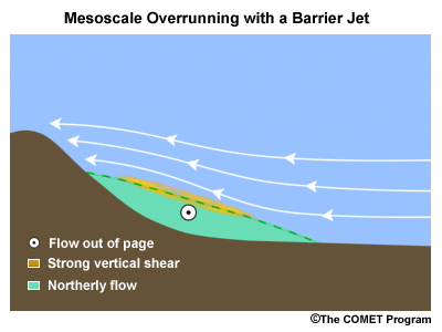
From a forecasting standpoint, barrier jets fundamentally change the dynamics of a flow situation and can drastically alter the thermodynamics of a precipitation scenario.
- Dynamics: Barrier jets can induce mesoscale overrunning of upstream low-level flow. This is inherently a producer of upward motion and can induce clouds and precipitation.
- Thermodynamics: Barrier jets can contain low-level cold advection, warm advection, or moisture advection within the jet itself. Thermal advection can determine precipitation type or generate convectively unstable lapse rates.
For barrier jets associated with significant overrunning and precipitation rates, melting of frozen hydrometeors can often induce enough cooling to cause the melting level to descend to the ground and the subsequent precipitation type to be snow or ice pellets.
Thermodynamic Impacts
- Overview
-
The relationship of the barrier jet to thermodynamic processes is essentially a two-way relationship, i.e., the jet affects the thermodynamics and the thermodynamics affect the jet. There are four main categories of processes that are relevant here:
- Cooling by melting
- Cooling by advection
- Lapse rate influences and convective instability
- Precipitation type influences
- Cooling by Melting
-
The barrier jet can induce a mesoscale overrunning process whereby an incoming air mass well upstream of the barrier is forced up and over the jet. The resulting production of clouds and precipitation creates precipitation or intensifies the existing precipitation rate.
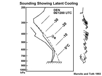
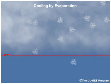
If the precipitation created is liquid, then the melting process is occurring somewhere in the cloud. Melting is a heat sink, thus there will be local cooling where that melting is occurring. This lowers the existing 0ºC level in the atmosphere; in some situations the barrier-jet-induced overrunning causes this level to reach the ground.
If the 0ºC level reaches the ground, then snowfall or frozen precipitation occurs. In many areas of complex terrain, the precipitation enhancement by the barrier jet causes frozen or freezing precipitation to occur instead of rain because of the existence of the barrier jet. This is relatively frequent along east slopes in the northern hemisphere, such as the Rocky Mountain Front Range and the Appalachian Mountains. There are also cases where the primary cause of the precipitation is the barrier jet itself, and this can initially be rain and subsequently turn to snow as the jet maintains its strength or intensifies.
In many documented cases, this scenario leads to an isothermal 0ºC layer through some depth of the lower atmosphere.
An additional cooling process is evaporation/sublimation (prior to precipitation). This can be important at the beginning of the event.
Current operational numerical models do not handle the thermodynamic processes of melting and evaporation/sublimation well in a relative sense, due primarily to limitations in vertical resolution, though the current performance is undoubtedly showing an improving trend.
- Cooling by Advection
-
The barrier jet induces movement of a low-level air mass in a direction parallel to the barrier, typically ageostrophically. Such movement can advect either warm or cold air into the region affected by the barrier jet.
On west slopes in the Northern Hemisphere, such as on the Sierra Nevada and Wasatch Ranges, warm air is drawn northward by the jet. This inflow, whether relatively dry or moist depending on the preexisting conditions, may destabilize the low levels upstream of the barrier and lead to convection.
On east slopes in the Northern Hemisphere, such as on the Rocky Mountains and the Appalachians, the inflow is often relatively cold. This often has significant precipitation type implications during the autumn or springtime with the precipitation against the east side of the barrier (and upstream of that region) changing up from rain to snow.
East of the Appalachian Mountains, cold advection is often enhanced by a barrier jet, leading to a situation where the surface-based cold layer is deeper than the operational models are predicting and extends further south than those predictions. In this situation, if the approach of a storm from the west or southwest leads to overrunning-type ascent above the cold layer, precipitation can be produced. If low-level cold temperatures persist (enhanced by the advection process) a sleet or ice storm may occur when large-scale operational guidance points toward rain.
- Lapse Rate Influences
-
Convective instability can be enhanced when the barrier jet draws warm, moist air northward, for instance on the west side of a barrier in the Northern Hemisphere. This can be a precipitation producer in the Wasatch Range of Utah, for example, where warm air is drawn northward upstream of the barrier while relatively low-theta-e air aloft simultaneously moves eastward.
By the same token, when the barrier jet draws cold air southward on the east side of a barrier in the Northern Hemisphere, low-level stabilization occurs. If precipitation is involved, and the low levels are initially well above 0ºC, an isothermal 0ºC layer may be produced, and it could reach the ground if the precipitation rate/melting effect is significant.
- Precipitation Type Influences
-
The barrier jet can:
- Induce mesoscale areas of frozen/freezing precipitation where large-scale guidance is pointing towards liquid.
- Induce three-dimensional gradients in precipitation, i.e., there may be local upslope or downslope areas within the barrier jet region that act to decrease or increase, respectively, the precipitation rate. Areas where the precipitation rate is increased are more likely to experience subsequent freezing or frozen precipitation during a situation where the initial surface temperatures are at or near 0ºC. The areas where the precipitation rate is locally smaller tend to remain locally warmer, thus liquid precipitation is more persistent.
Historical Studies
- Overview
-
Climatologies of barrier jets are rare to unavailable, so the next best thing is documented cases. This section is intended to show that the phenomena occurs in many areas of varying complex terrain, and is thus a forecast challenge.
- Baffin Island, Nunavut
-
Look at this climatological wind rose for November from the Clyde surface observing site (CYCY) located on the southeast corner of Baffin Island:
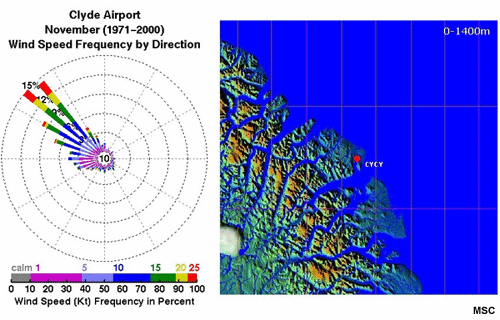
Note the two dominating characteristics of the wind direction an speed:
- The observed northwesterly wind direction is much more common overall than the other directions.
- Observed strong winds at this site are nearly always northwesterly.
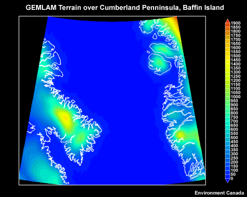
Here is a more general look at the plot of model elevation for the area:
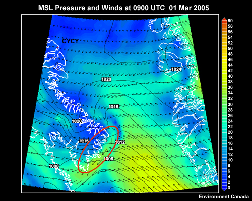
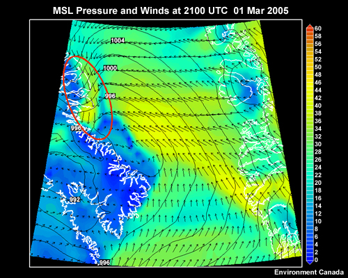
One example for a case occurring in March 2005 illustrates the barrier influence off of the southeastern corner of Baffin Island (these are GEM-LAM lowest-level wind fields and MSLP):
- Appalachian Mountains, Eastern U.S.A.
-
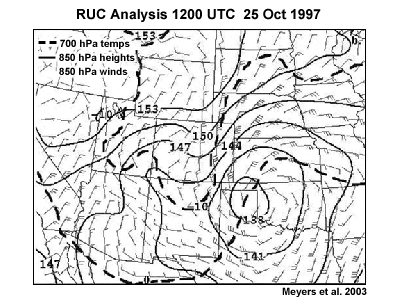
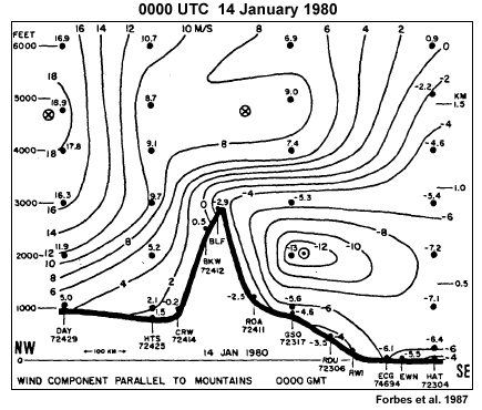
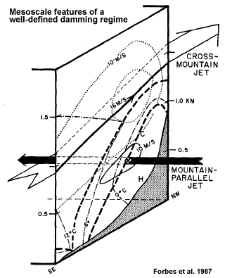
Forbes et.al. (1987) documented a strong cold-air damming case along the east slopes of the Appalachian Mountains that included a low-level northeasterly jet parallel to the mountains (see fig. 1).
The presence of the jet led to low-level temperatures cold enough for an extensive ice storm, while large-scale guidance had indicated rain would be dominant. Upward motion within the relatively warm southeasterly flow above the jet provided the initial hydrometeor supply for the precipitation (see fig 2).
That air mass was essentially being lifted by the underlying barrier jet. A similar dynamic and thermodynamic scenario set up during the March 1990 and March 2003 events in the Rocky Mountains, but in those events, snow was the dominant precipitation type instead of freezing rain.
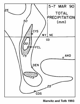
- Rocky Mountain Front Range, Colorado
-
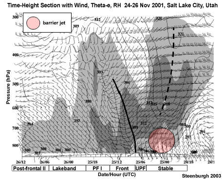
Marwitz and Toth (1993) analyzed a Colorado Front Range storm during 3-7 March 1990. The event was warm enough to initially produce rain in the urban corridor, but changeover to snow soon occurred and was permanent in the urban corridor. A significant, persistent rain/snow line set up in the vicinity of the north-south-oriented highway I-25. The closely associated northerly barrier jet that developed manifested itself as a mesoscale frontal zone and was the major factor in the precipitation type and distribution. The location of the barrier jet was just west of the rain/snow line, and it manifested itself as the north-northwesterly flow in the lowest portion of the sounding. Heaviest snowfall occurred in the foothills just west of the urban corridor.
- Other Regions
-
Other regions in the Rockies are also characterized by cold season northerly barrier jet scenarios, including the Alberta Rockies, the Bighorn Mountains of northeastern Wyoming, and the Wind River Range of west-central Wyoming.
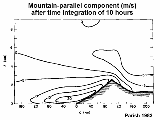
Barrier jets that involve an acceleration of southerly winds have been observed in the Wasatch Range of Utah and the Sierra Nevada of California. For the latter, the Parish (1982 JAM) study demonstrated a 2-D simulation of the barrier jet near Lake Tahoe, the results of which compared well with observations in a case study. Impinging synoptic westerly flow (left to right in the Figure) was blocked and southerly flow developed (into the page):
In Alaska, the Brooks Range has barrier jets, and in the Antarctica the Antarctic Peninsula and the Trans_Antarctic Mountains are also favorable locations. The same can be said for the Alps of Italy.