Winds, Cold Currents, and Coastal Upwelling
Introduction
One of the key ingredients in coastal fog formation is an appreciable temperature difference between the ocean and the lowest portions of the atmosphere. The advection of the warm air mass westward (described in the Preconditions section) contributes to this difference. Fog formation is favored in areas where there are greater temperature contrasts between the sea surface and the air above it. Cold ocean currents and upwelling are two mechanisms that enhance such temperature contrasts.
Cold Ocean Currents
Cold ocean currents are a main source of cold surface waters in coastal zones. Such currents are found in association with the west coast fog regions we have identified along the coasts of Africa and the Americas. The California Current carries cold water from the north Pacific to the coastal regions of Washington, Oregon, and Northern California.
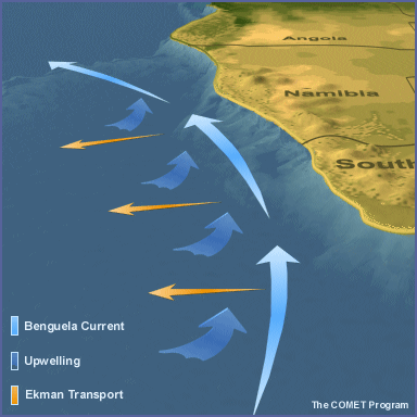
This flow of cold water occurs in association with low-level northwesterly winds on the east side of the subtropical high. The northward-flowing Peru Current is its counterpart in the south Pacific, cooling coastal waters of Chile and Peru. The Benguela Current has the same effects, flowing northward along the coasts of South Africa, Namibia, and Angola.
Upwelling
Upwelling is another process that causes cold subsurface waters to rise to a sea surface. It is caused by various mechanisms, depending on location, bathymetry, and interaction with prevailing air streams (one of these mechanisms is related to the Ekman transport).
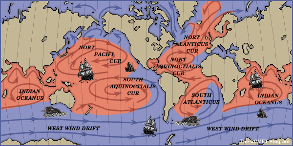
Generally, offshore flow enhances upwelling, as well as certain along-shore wind components (northerlies in the northern hemisphere west coasts and southerlies in the southern hemisphere west coasts). This map shows the main regions of coastal and oceanic upwelling around the world.

Note in this map that large bands of upwelling are found along the western coasts of North America, South America, and Africa. These are areas where upwelling is enhanced by Ekman transport.
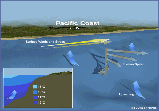
Ekman Transport
Ekman transport is a process that enhances upwelling. Wind stress on the ocean surface, when combined with the Coriolis effect, causes shallow water (tens of meters deep) to move 90° to the right (in the northern hemisphere, left in the southern hemisphere). This offshore movement of shallow water draws cold subsurface waters upward to replace the displaced surface water.
This process is illustrated by the animation below. Note how water at the surface moves 45° to the right while deeper water moves right at progressively greater angles with increasing depth. This is referred to as the Ekman spiral. The combined effect is a net transport of 90°.
Seasonal SST Variations
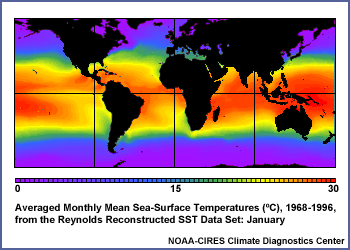
The amount of upwelling varies by season because it depends on the speed, duration, fetch, and direction of the winds that drive it. The following animation shows mean monthly sea surface temperatures averaged over the period 1968-1996. Note in this animation the areas of relatively cool coastal waters at different times of the year along the west coasts of North America, South America, North Africa, and South Africa.
Current SST data are available from many locations on the World Wide Web. One such site, with particularly nice graphics, is the Sea Surface Temperature resource page at the University of Wisconsin's Space Science and Engineering Center.

The Benguela Current
Off the west coast of Africa, the cold Benguela Current reduces the sea temperature by about 4°C below the latitude mean. Within the current, surface water drifts away from the coast and its place is taken by water from a depth of about 200 m. This upwelling water further decreases the surface temperature to about 5°C below the climatological average in summer and 3°C below the average in winter. Upwelling also appears along the African south coast in summer with northeasterly winds.
Seasonal Variations
Although the general seasons of most pronounced upwelling last several months, upwelling is not constant during these entire periods. Synoptically-induced increases in the alongshore component (if equatorward for west coasts) of the wind cause short-term "upwelling events" to occur over periods of days or weeks. During such events, sea surface temperatures can decrease rapidly in the affected region.
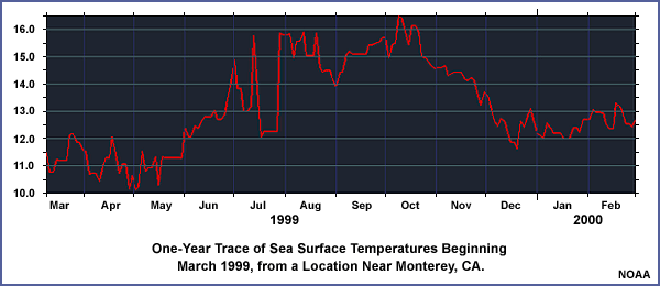
This graph shows variations in average sea surface temperatures over a 12-month period near the Monterey Peninsula on the California coast. SSTs generally rise in the warm season and lower in the cool season, but there are numerous short-term fluctuations in temperature. For example, note the sudden cooling of nearly 4°C that occurred during July 1999.
Local Variations
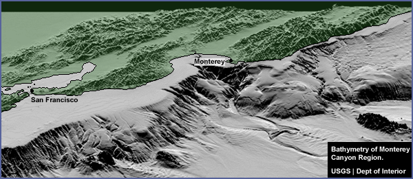
Local variations in sea surface temperatures are also influenced by variations in the coastal bathymetry. Upwelling is stronger above areas with oceanic ridges (such as the Mendocino ridge west of Cape Mendocino, CA) or steeply sloping bathymetry (such as the Monterey submarine canyon near Monterey, CA), while weaker upwelling occurs over gently sloping bathymetry.