Heat Low
The heat low refers to a persistent low pressure center in the MSLP contours generally centered over the extreme southwestern U.S., including southwestern Arizona and southern California. Frequently the heat low extends northward into central California along the elevated terrain there (see figure).
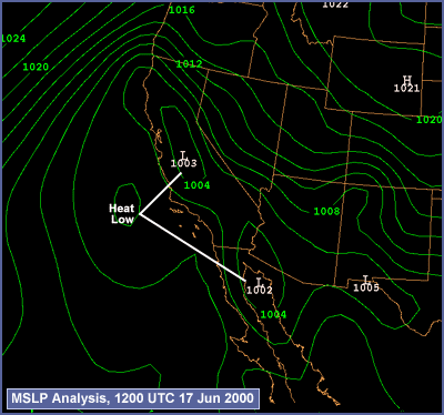
The heat low is partially a result of the practice of reducing station-observed barometric pressure down to sea level in order to get a consistent large-scale analysis of pressure. In this sense the heat low is a figment of the analysis procedure, since it must presume some lapse rate below the ground based on the observed surface temperature. During the hot summer months, the presumed temperature profile below the ground is unrealistically hot, leading to reduced surface pressure. This effect is most pronounced in regions of elevated terrain.
Due to the presence of the heat low and persistent low-level high pressure off the coast of California related to the subtropical high, typically there is a significant pressure gradient oriented west to east over the California coastal region during the summer, and persistent northerly winds. The hot spell fogs discussed in this module require a disruption of this wind pattern and significant offshore winds, due to the intrusion of high pressure into the northwestern U.S. and Great Basin. When the offshore winds subside and the heat low begins to reassert its presence, the stage is set for a coastal fog outbreak.