Produced by The COMET® Program
Introduction
For more information on The PBL in Regions of Complex Terrain, see this module:
https://www.meted.ucar.edu/training_module.php?id=258
This module builds upon the topic presented in The PBL in Regions of Complex Terrain Webcasts ( https://www.meted.ucar.edu/training_module.php?id=258 ). The goal of this module is to explain the effects of weather in complex terrain on fire behavior and strategies for fighting wildfire. To isolate the mesoscale meteorological effects, we assume that the synoptically driven flow in our scenario is negligible and the weather conditions are only affected by diurnal heating and nocturnal cooling.
By the end of this module you should be able to:
- Describe the effects of thermally forced winds in complex terrain on fire behavior
- Identify how suppression operations are related to fire and smoke conditions
For more information on fire behavior see the Fire Behavior module:
https://www.meted.ucar.edu/training_module.php?id=468
Morning
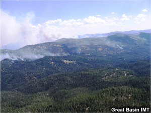
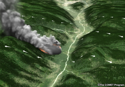
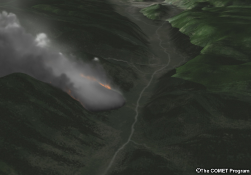
In this example of a mountain valley location, a fire is burning near the base of the east facing slope. The Incident Commander (IC) and Fire Behavior Analyst (FBAN) are located in the valley as shown. A fire fighter near the fire is relaying information on fire behavior and weather conditions. The Incident Commander looks to you to describe the expected weather conditions. The Fire Behavior Analyst will explain the fire behavior expected with the forecast weather conditions.
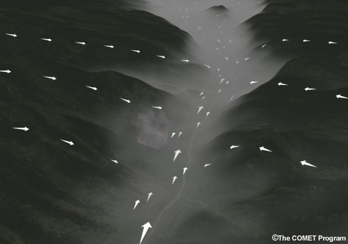
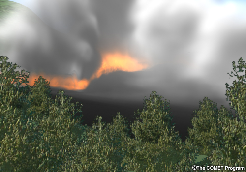
Early morning fire and wind conditions in a mountain valley..
The Incident Commander describes current conditions and effects on operations, and has a couple of questions for you:
Incident Commander:
"Smoke has settled into the valley overnight and is causing some problems with aviation
operations. Also, we are concerned about the smoke affecting people on the fire line. How
long will these smoky conditions exist after the sun rises? The wind flow will affect how we
place our resources. What are the winds expected to do after sunrise?"
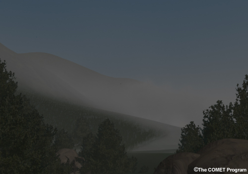
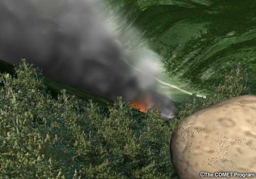
Smoke settles into the valley overnight.
Before answering his questions, let's find out what is being observed at the fire:
Fire fighter:
Right now we are in very thick smoke, the fire is not very active, and with the cooler
temperatures and higher humidity, we've been able to make good progress overnight. The winds
are flowing down the slope and down the valley at a steady pace and seem to be limiting the
spread of the fire up the slope. Since it's almost sunrise, we are waiting to hear the plan
from the Incident Commander once the sun rises.
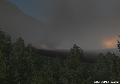
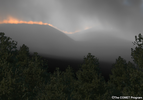
Fire fighters observe thick smoke and less active fire behavior in the early morning hours.
Question
Keeping in mind the questions that the Incident Commander asked about the persistence of the smoky conditions and changes in windflow after sunrise, the Incident Meteorologist (IMET) on the fire asks you to evaluate the situation:
IMET:
Describe what you would expect to happen based on your knowledge of typical mountain/valley
flow characteristics and diurnal changes in temperature and relative humidity.
Smoky conditions in the early morning hours.
The correct answers are a, b, and d.
Feedback:
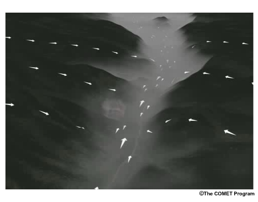
Prior to sunrise, there is strong down valley flow and flow on the slopes is
strongly downslope. As the sun comes up, the flow on the east facing slope
begins to switch from downslope to upslope. The down valley flow decreases
in strength and ends by mid-morning. The winds on the west facing slope
remain in shadow, so changes in the flow on that slope are slower to occur.
As the sun hits the valley floor in the morning, smoke trapped in the valley
begins to lift and quickly mixes out. As the sun rises, the temperature
starts to increase and the humidity, which is highest just before sunrise,
starts to decrease.
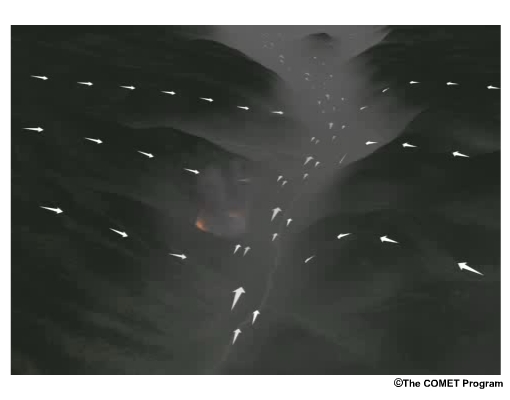
As the sun rises, smoke begins lifting out of the valley.
The Fire Behavior Analyst (FBAN) explains how the expected weather conditions could affect fire spread and growth.
FBAN:
The result of the increased temperature and decreased humidity is increased
fire activity. The smoke will lift as the inversion breaks and the fire will
be better ventilated, allowing it to grow. The spread of the fire is
affected by both the natural tendency for it to move up slope and the
direction of the wind. Therefore, the initial downslope winds will act
against the slope effect and the fire will creep along the slope. Once the
sun comes up and the winds switch to direction, the fire spread will
increase upslope as the upslope winds strengthen.

Slope winds flow developing after sunrise.
Based on expected changes in weather conditions and the FBAN's analysis of the expected fire behavior, the Incident Commander has decided to move fire fighting resources:
Incident Commander:
In anticipation of sunrise, we are going to concentrate the crews along the
rear and flanks of the fire so that they are out of the way when the winds
shift and the fire starts increasing its upslope progression.
Fire fighter location as winds and fire move upslope.
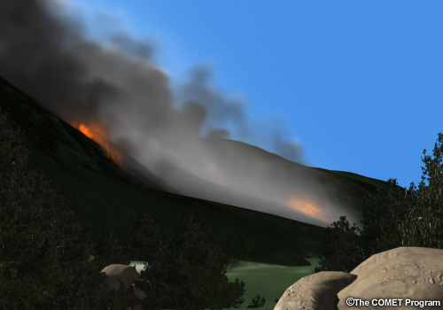
Afternoon
By mid-morning, the fire has begun burning up the east facing slope. The fire fighters have moved to the flanks of the fire. The Incident Commander asks to you to describe how conditions will change into the mid-afternoon. The FBAN is available to explain the fire behavior expected with the forecast weather conditions.
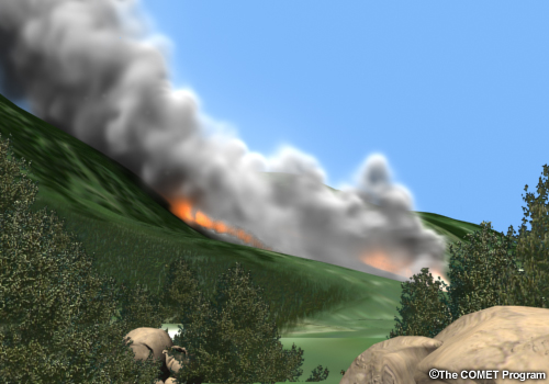
Fire moving up the east facing slope in late morning hours.
Fire fighters work along the flanks of the fire.
View of the fire from the valley.
The Incident Commander updates you on the fire conditions and current operations, and has follow-up questions for you:
Incident Commander:
The fire is moving swiftly up the slope and smoke has cleared out and is ventilating well.
We have people working the flanks of the fire. How do you expect the weather conditions to
change moving into the afternoon, especially on the east facing slope? Do you expect a
significant increase in wind speeds?
View of fire in late morning from Incident Command Center.
The fire fighter reporting from the fire location, also has an update:
Fire fighter:
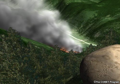
The fire has grown significantly and is moving at a good rate of spread. We are working on
the flanks, but there is a forested area slightly up the valley, which could cause problems
if the fire reaches that area.
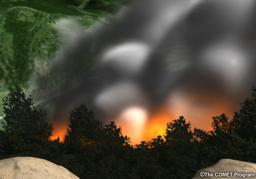
Fire fighters observe increase in fire activity after the sun rises.
Question
Keeping in mind the questions that the Incident Commander asked about changing conditions on the east facing slope and specifically about increasing wind speed, the Incident Meteorologist (IMET) on the fire asks you to evaluate the situation:
IMET:
Describe what you would expect to happen based on your knowledge of typical mountain/valley
flow characteristics and diurnal changes in temperature and relative humidity.
View of fire in late morning from Incident Command Center.
The correct answers are a and c.
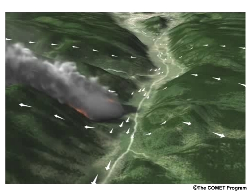
Feedback:
The wind will continue to move upslope and strengthen, and an upvalley
component will begin to develop. The resulting flow will have a cross slope
component. The temperature will increase to near the warmest of the day and
the relative humidity will drop to near its minimum value.
Upvalley flow begins to develop in the afternoon.
The Fire Behavior Analyst (FBAN) explains how the expected weather conditions could affect fire spread and growth.
FBAN: –
Upslope winds act with the natural tendency of the fire to move up a slope
and increase the spread of the fire. The spread rate is related to the wind
speed, so as the upslope flow strengthens, the fire moves more quickly.
Also, as the inversion lifts, the fire will grow vertically. We are
concerned about the fire moving into the trees up the valley. The fire could
then move into the tree crowns and result in extreme crown fire behavior.
The higher temperatures and lower relative humidity will also aid in the
fire spread by preheating and drying fuels. The mid to late afternoon is
normally when the most active fire behavior occurs.
Fire behavior becomes more active in the afternoon.
Based on expected changes in weather conditions and the FBAN's analysis of the expected fire behavior, the Incident Commander has decided how to best place fire fighting resources:
Incident Commander:
We'd really like to work on the upvalley flank of the fire to keep it from
moving into the trees. However, if the winds will start to push the fire up
the valley, we will have to move those resources and concentrate our efforts
on the down valley flank. We can't put our fire fighters in danger.
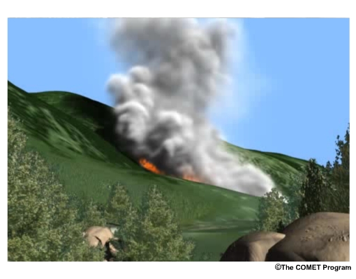
View of the fire in late afternoon.
Overnight
By late-afternoon, the fire continues to burn up the east facing slope and has also taken on an upvalley component of spread. The fire fighters have moved to the downvalley flank of the fire. The Incident Commander asks to you to describe how conditions will change overnight. The FBAN is onsite to explain the fire behavior expected with the forecast weather conditions.
Fire moving up the east facing slope in late afternoon hours.
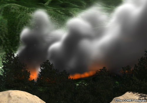
Smoke is rather thick with increased fire activity.
View of the fire from the northridge lookout.
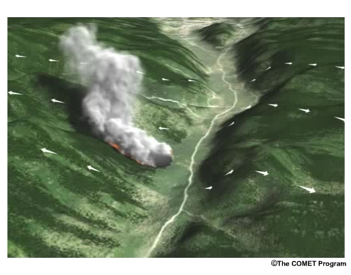
Effects of upvalley flow cause the fire spread to have a cross-slope component.
The Incident Commander updates you on the fire conditions and current operations, and has follow-up questions for you:
Incident Commander:
The fire fighters have seen some very active fire behavior, but we are hoping that once the
sun goes down, we will see some relief in the hot temperatures and low humidity. However,
the direction and strength of the wind will determine where we place our resources. How do
you expect the winds to change overnight, and what about the inversion? Will it form again
tonight?
Fire viewed from the Incident Command Center in the late afternoon.
The fire fighter has seen a great increase in fire spread:
Fire fighter:
These afternoon conditions are causing the fire to take off. We are working as hard as we
can, but the fire is moving up the slope quickly and starting to move up the valley as well.
This is the most difficult part of the day in terms of working the fire and being aware of
potentially dangerous conditions.
View from the perspective of a fire fighter at the scene.
Question
Keeping in mind the questions that the Incident Commander asked about changes in winds and the development of an inversion, the Incident Meteorologist (IMET) on the fire asks you to evaluate the situation:
IMET:
Describe what you would expect to happen based on your knowledge of typical mountain/valley
flow characteristics and nocturnal changes in temperature and relative humidity and typical
formation of a radiation inversion.
Fire viewed from the valley.
The correct answers are a, b and d.
Feedback:
In the late afternoon, the highest temperatures, strongest upslope and
upvalley winds and lowest humidities will be present. As the sun goes down,
the slope winds will turn downslope, and the upvalley wind will decrease and
cease. As the downslope winds increase in strength, a downvalley component
of the wind begins to form. As the valley cools overnight, the temperature
near the fire will drop and the relative humidity will increase. As the
temperature drops in the valley, a radiation inversion will develop,
initially near the valley floor.
Downslope and later downvalley winds develop overnight.
The Fire Behavior Analyst (FBAN) explains how the expected weather conditions could affect fire spread and growth.
FBAN:
The mid to late afternoon often sees the most active fire behavior. With the
high temperatures and low relative humidities, fuels are preheated and
dried. Also, the upslope and upvalley flow cause relatively fast spread up
and along the slope. As the sun goes down and the upslope and upvalley winds
decrease, the upslope spread of the fire will begin to slow. The cooler
temperatures and higher relative humidity will reduce the fire activity as
fuels react to the cooler, more moist conditions. As the downslope winds
develop, the upslope fire spread will continue to decrease and the
downvalley component of the winds can cause a change in the direction of
spread. However, both downslope and downvalley winds act against the natural
tendency for fire to move uphill, and the fire spread in general should be
distinctly slower than seen in the afternoon hours. The inversion (the
region where the temperature increases with height) that forms in the valley
will have the effect of decreasing fire behavior beneath it. In this area,
great progress can be made in fighting the fire. Meanwhile, the portion
along the slope near the top of the inversion is known as the thermal belt,
where the relative humidity will continue to be lower and more active fire
behavior can be observed.
Based on expected changes in weather conditions and the FBAN's analysis of the expected fire behavior, the Incident Commander has decided how to best place fire fighting resources:
Incident Commander:
Nighttime hours are when we often make the most progress on fighting the
fire. I plan to concentrate on the upvalley flank of the fire and try to
create some good fire breaks in anticipation of what will happen tomorrow
when the wind shifts again. Near the top of the inversion, I'll alert the
fire fighters that fire behavior may be more active in that region. We also
need to be careful under the inversion, as smoky conditions can affect the
fire fighters.
Late afternoon conditions.
Summary
As a forecaster, you may well be aware of the changes in wind speed and direction in a mountain valley due to diurnal heating and nocturnal cooling. These conditions have distinct effects on fire behavior. The key points to take away from this module are:
- The direction that the fire spreads is greatly influenced by the wind direction
- Fires naturally spread uphill, so interaction between the slope winds and the direct effects of terrain can work together to enhance fire spread, or can work against each other to suppress fire spread
- Development of a radiation inversion affects both fire activity and the ventilation of smoke from the fire
- The natural diurnal changes in relative humidity and temperature also affect fire behavior by warming and drying fuels during the day and cooling and increasing fuel moisture at night
- In the absence of synoptic forcing, under cloudless conditions, the strongest enhancement of fire spread up the slopes and valley typically occurs in the late afternoon.

Effects of terrain and mesoscale winds on fire behavior.
Contributors
COMET Sponsors
The COMET® Program is sponsored by NOAA National Weather Service (NWS), with additional funding by:
- Air Force Weather (AFW)
- Australian Bureau of Meteorology (BoM)
- Meteorological Service of Canada (MSC)
- National Environmental Education Foundation (NEEF)
- National Polar-orbiting Operational Environmental Satellite System (NPOESS)
- NOAA National Environmental Satellite, Data and Information Service (NESDIS)
- Naval Meteorology and Oceanography Command (NMOC)
Project Contributors
Science Contributors
- Myron Hotinger — Bureau of Land Mangement
- Dr. Elizabeth Mulvihill Page — UCAR/COMET
- Dr. Doug Wesley — UCAR/COMET
- Dr. Dave Whiteman — University of Utah
Project Lead
- Dr. Elizabeth Mulvihill Page — UCAR/COMET
Computer Graphics/Interface Design
- Steve Deyo — UCAR/COMET
- Brannan McGill — UCAR/COMET
Multimedia Authoring
- Dan Riter — UCAR/COMET
Audio Editing/Production
- Seth Lamos — UCAR/COME
Audio Narration
- Dr. Alan Bol — UCAR/COMET
- Dr. Greg Byrd — UCAR/COMET
- Jennifer Frazer — UCAR/COMET
- Hildy Kane — UCAR/COMET
COMET HTML Integration Team 2020
- Tim Alberta — Project Manager
- Dolores Kiessling — Project Lead
- Steve Deyo — Graphic Artist
- Gary Pacheco — Lead Web Developer
- Justin Richling — Associate Scientist
- David Russi — Translations
- Gretchen Throop Williams — Web Developer
- Tyler Winstead — Web Developer
COMET Staff
Director
- Dr. Timothy Spangler
Deputy Director
- Dr. Joe Lamos
Administration
- Lorrie Alberta
- Michelle Harrison
- Hildy Kane
Graphics/Media Production
- Steve Deyo
- Seth Lamos
- Brannan McGill
Hardware/Software Support and Programming
- Tim Alberta (IT Manager)
- James Hamm
- Ken Kim
- Mark Mulholland
- Dan Riter
- Carl Whitehurst
- Malte Winkler
Instructional Design
- Patrick Parrish (Production Manager)
- Dr. Alan Bol
- Lon Goldstein
- Bryan Guarente
- Dr. Vickie Johnson
- Bruce Muller
- Dwight Owens (Alphapure Design Studio)
- Marianne Weingroff
Meteorologists
- Dr. Greg Byrd (Project Cluster Manager)
- Wendy Schreiber-Abshire (Project Cluster Manager)
- Dr. William Bua
- Patrick Dills
- Dr. Stephen Jascourt
- Matthew Kelsch
- Dolores Kiessling
- Dr. Arlene Laing
- Dr. Elizabeth Mulvihill Page
- Warren Rodie
- Amy Stevermer
- Dr. Doug Wesley
Science Writer
- Jennifer Frazer
Spanish Translations
- David Russi
NOAA/National Weather Service - Forecast Decision Training Branch
- Anthony Mostek (Branch Chief)
- Dr. Richard Koehler (Hydrology Training Lead)
- Brian Motta (IFPS Training)
- Dr. Robert Rozumalski (SOO Science and Training Resource [SOO/STRC] Coordinator
- Ross Van Til (Meteorologist)
- Shannon White (AWIPS Training)
Meteorological Service of Canada Visiting Meteorologists
- Phil Chadwick
- James Cummine