Introduction
Welcome to Introduction to Fire Behavior
This site provides an overview of factors that affect the ignition and spread of wildfire. Information is presented with 3-dimensional graphics and animations as well as audio descriptions and commentary provided by a fire behavior expert. You don't need an extensive background in fire science or weather forecasting to use this site. If you come across a word that you don't recognize, you can access a fire weather glossary.
The content is taken from the COMET CD-ROM-based training module Fire Weather that was originally developed for and distributed to operational weather forecasters.
Introduction to the Fire Environment
Topography
Summary

Topography exerts a major influence on weather and fire conditions, especially in areas of complex terrain. It is a major factor in determining the type and amount of fuels, and it influences fire ignition, intensity, direction, and rate of spread.
Aspect, the direction a slope is facing, directly affects fire danger and fire behavior by varying the amount of solar radiation that each slope receives.
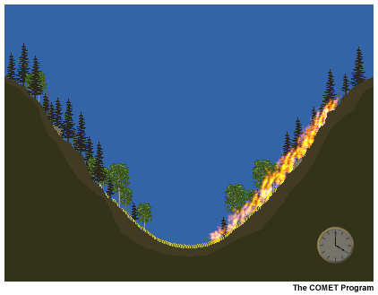
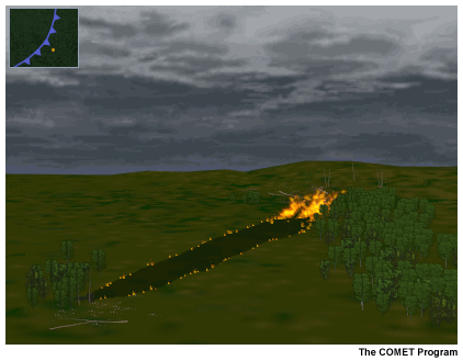
Slope, the percent of incline (steepness), is an important factor in determining how fires ignite and spread. Flame lengths are longer on steeper slopes. This lets them effectively preheat the fuels upslope and contributes to more rapid fire spread.
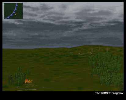
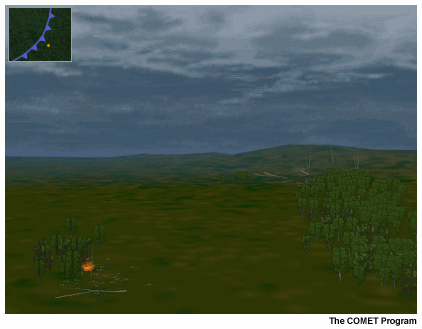
The position of a fire on a slope effects its size and spread. A fire that starts at the bottom of the slope is likely to become larger than one which starts mid-slope or near the ridge line. This is because the slope effects the preheating of fuels and enhances uphill fire spread. More importantly, a fire that starts at the base has a longer uphill run with more fuel in its path.
Slope wind variations:
Upslope winds develop on east-facing aspects first because they receive direct sunlight earlier. The winds peak earlier (usually around noon) and then diminish as solar heating becomes stronger on the south and west aspects. Downslope winds also develop here first, after a period of transition, when the slope becomes shaded.
North-facing aspects have the lightest upslope winds.
South-facing aspects have the strongest upslope winds because they receive the greatest amount of solar radiation. Winds peak in the early to mid-afternoon. Downslope winds begin after the slope loses direct solar heating, usually after sunset.
Upslope winds start and peak later in the day on west-facing aspects than on east and south aspects. Peak wind speeds usually occur in the late afternoon. Average wind speeds are higher than on east aspects, although normally lower than on south aspects. Downslope winds typically continue for some time after sunrise because of slope shading.
At night, downslope winds form and cooling temperatures cause the RH to increase. The cooler air pools in the bottom of the valley and results in an inversion. A thermal belt forms around the top of the inversion which is often near the middle of the slope. This area has higher average temperatures and lower average RH than any other part of the valley or slope during the night.
Thermal Belts
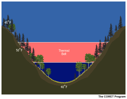
At night, downslope winds form and cooling temperatures cause the RH to increase. The cooler air pools in the bottom of the valley and results in an inversion. A thermal belt forms around the top of the inversion, which is often near the middle of the slope. This area has higher average temperatures and lower average RH than any other part of the valley or slope during the night.
Thermal Belt Question
Assume that fire encompasses one of the slopes from bottom to top. What will happen to the fire activity at night when a thermal belt forms? Click the correct answer.
The correct answer is c).
The part of the slope within the thermal belt can experience active burning throughout the night because it will have the warmest average temperature and the relative humidity often will not get high enough to cause the fire to die down.
Steepness of the Slope
Fire behavior is affected by other topographic factors. For example, the steepness of the slope plays an important role in determining how fires spread.
Flame Lengths on Steeper Slopes
Flame lengths are longer on steeper slopes because the steepness has the same effect as a stronger wind. The longer flames preheat the fuels farther up the slope and contribute to more rapid fire spread.
Position of a Fire on a Slope
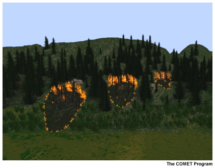
The position of a fire on a slope affects its size and spread. A fire that starts at the bottom of the slope is likely to become larger than one that starts mid-slope or near the ridge line. That's because the fire has a longer upslope run with more available fuel in its path.
Firebrands

Although fires that start mid-slope tend to spread uphill, firebrands (pieces of burning debris such as rolling logs or pine cones) can spread fire downslope.
Slope and Valley Winds
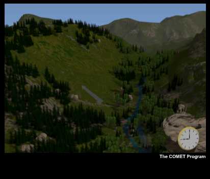
In a mountain valley, the slopes along the valley heat in the morning, and upslope flow develops. Later in the day, the winds develop an up-valley component, so that the flow is across the slope and up the valley.
The animation shows how the direction of fire spread changes as the direction of the local wind changes. This typically happens during the afternoon when the up-valley wind dominates the upslope wind.
Fuels
Fuel Complex
A fuel complex is the composite of the vegetation (both alive and dead) and other organic material on a site that can burn.
When assessing a fuel complex, a fire manager considers the following questions:
How much fuel is present?
How much fuel is available to burn?
3 Levels of Fuels
The first step in evaluating a fuel complex is to assess the fuel loading, that is, the amount of organic material (both dead and alive) in the local environment.
Fuels are found at 3 levels:
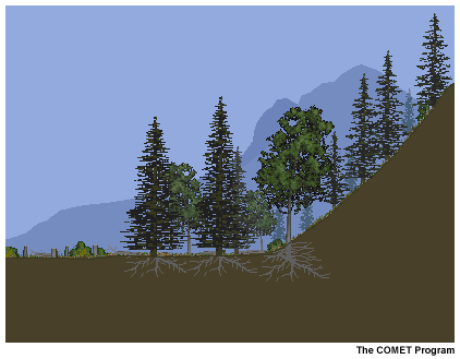
Aerial fuels are all live and dead vegetation located in the forest canopy or above the surface fuels, including tree branches and crowns, snags, moss, and high brush.
Surface fuels are any fuels that are contiguous with the ground, such as grass, brush, timber litter (branches, twigs, or bark fallen from trees), and logging slash (residue from logging).
Ground fuels include all combustible materials lying beneath the ground surface, including rotten buried logs, roots, peat, decomposing leaves, and duff (decaying material).
Changes to Fuel Loading
Although an area's fuel loading remains relatively constant, weather conditions can alter it. For example, more grass is produced in wet years than during periods of drought.
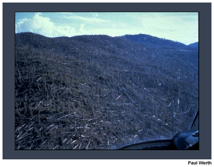
The picture shows the effect of a microburst that changed the amount of dead, surface fuel south of Yellowstone National Park in 1988. The microburst blew down thousands of acres of trees which had been weakened by insects. After the timber dried out, it became volatile surface fuel.
Introduction - Available Fuel
Not all organic material in an environment is considered available fuel, that is, material (either dead or live) that is available to burn. Some may be too moist to ignite or carry fire.
Available Fuel
Fire managers determine the amount of available fuel by considering 3 questions:
- What types of fuels are in the complex?
- How are the fuels arranged: horizontally and vertically?
- What is the state of the fuels: dead or alive, moist or dry?
Fuel Types
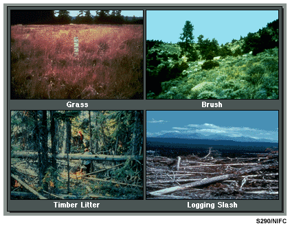
Surface fuels are of greatest concern because they are primary contributors to the intensity and spread of fires. As mentioned earlier, the 4 types of surface fuels are:
- Grasses
- Brush
- Timber Litter (mixed litter, leaves, needles, large branches)
- Logging Slash (residue from logging, such as limbs)
Fuel Moisture Content
Most fuel complexes have a combination of dead and live fuels, and some fuels can have both dead and live components.
Fuel moisture content is the amount of water in a fuel, expressed as the percentage of its oven dry weight (the weight of the fiber with all moisture driven off). The fuel moisture capacity varies for dead and live fuels. Dead fuels can have fuel moistures of up to 30% (beyond which the cells cannot hold additional water), whereas the fuel moisture content of live fuels can reach 300%.
Live and Dead Fuels
Fires ignite and burn poorly, if at all, when fuel moisture content is too high. With low fuel moisture, fires start easily and spread rapidly.
Live fuels can burn when their moisture content is very low or when they are sufficiently preheated by nearby burning fuels, although certain highly volatile fuels can burn even with high moisture content.
Fuel Moisture Changes
Fuel moisture changes differently in live and dead fuels.
- In live fuels, fuel moisture changes on a seasonal basis in response to normal stages of plant development. However, abnormal conditions, such as drought, insect infestation, disease, and freezing temperatures, can modify the moisture content of live fuels.
- In dead fuels, fuel moisture typically changes on a daily basis in response to changes in RH, temperature, wind, and precipitation. The rate of change also depends on the shape and size (surface area/volume ratio) of the fuel.
Weather
Introduction
This scenario allows you to explore the effects of weather parameters on fire ignition and spread.
Summer
Assume that it's summer and that the fuels in this environment (grass, logs, and timber litter) have dried out due to a period of high temperatures and low humidity. The probability of fire ignition is high, and any fires that start are likely to spread rapidly through the dry fuels.
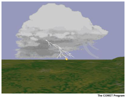
Dry or Wet Thunderstorm
An approaching cold front has spread clouds over the area, and the airmass has become more unstable, resulting in the development of thunderstorms.
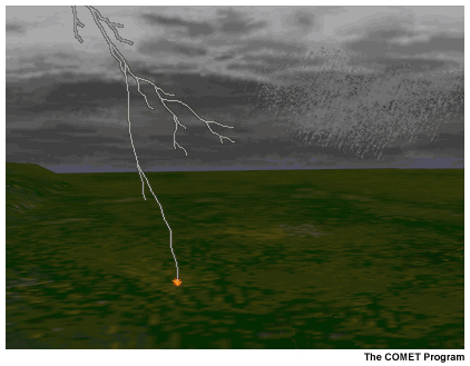
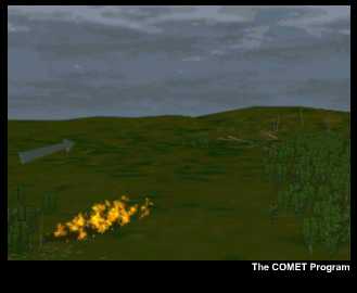
Lightning strikes a tree. A fire starts in the timber litter at the base and spreads out to the grass. The extent to which it continues to burn and spread depends on whether the thunderstorm is dry or wet.
Dry Thunderstorm Question
Since there is no rain to put out the fire, the strong winds ahead of the cold front cause the fire to spread.
Click the shape that the fire will most likely assume.
The correct answer is a).
The strong winds will cause the fire to spread in an elongated ellipse.
Wind Speed and Direction
The shape, direction, and rate of spread of a fire are determined primarily by wind speed and wind direction, although fuel type, fuel moisture, and terrain characteristics are also important.
Wind speed affects the shape of a fire in that a stronger wind will create a longer elliptical-shaped fire. When the wind is light, the fire takes on a more rounded shape.
Wind direction usually determines the direction of fire spread, although fire can move in any direction if other factors, such as the steepness of a slope, dominate.
Crown Fires
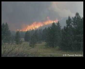
The fire spreads through the grass to the timber litter and up into the trees. This causes a crown fire, one which burns and spreads in the tops of the trees.
Crown fires can be very intense and have rapid rates of spread, moving several miles per hour. Suppression efforts are not effective. When faced with crown fires, fire crews have to move to safer areas.
Firebrands
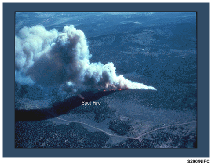
In addition to rapidly spreading the fire, strong winds can carry embers or sparks (firebrands) ahead of the main fire which can help to start new fires. This is known as spotting.
The potential for firebrands to start new fires depends on the amount of solar heating, which affects temperature and fine fuel moisture. This potential is referred to as the probability of ignition.
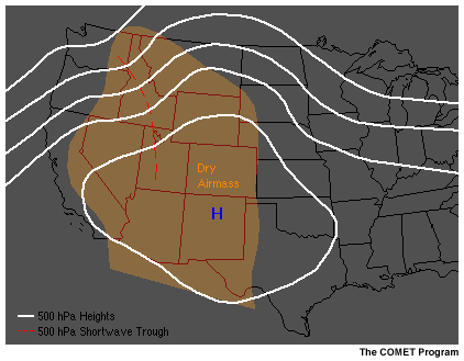
Critical Fire Weather Patterns
Breakdown of the Upper Ridge
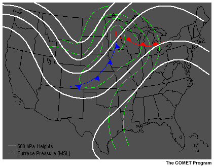
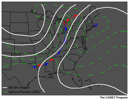
Recognizing Evolving Patterns

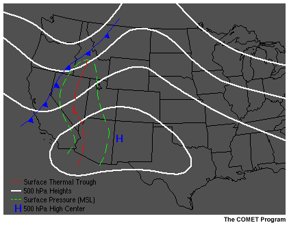
The breakdown of an upper ridge can occur quite rapidly. The first indication is often an apparent deepening of an upstream trough as a shortwave feature begins to move into the west side of the ridge. Winds often become more southerly near the surface and increase in speed as low-level instability increases mixing. If the mid- to upper-level pattern is progressive, the shortwave feature will flatten the ridge and the upstream trough will move eastward or northeastward.
Associated Weather Conditions/Effects on Fuels and Fire Conditions
Persistent surface high pressure areas and associated upper-level ridges produce hot temperatures and low humidities which can dry fuels to critical levels. The shortwave trough initiating the breakdown will increase the instability of the atmosphere, and convection associated with the breakdown can produce thunderstorms with little or no rain. Lightning can ignite fires in the dry fuels, and rapid fire spread is likely due to gusty surface winds. Strong winds mixing to the surface can also be associated with this instability.
Northwest/Intermountain West
In the Northwest and Intermountain West, the breakdown usually provides only minor temperature and humidity relief. There is often enough mid-level moisture to trigger thunderstorms, but little if any rain may reach the surface. Downburst winds from these dry thunderstorms can produce rapid fire spread, and dry lightning can ignite new fires.
Midwest/Great Lake States
In the Midwest and Great Lake States, the breakdown is usually associated with a strong, fast moving surface system. Violent thunderstorms, strong winds, and rain are normally focused in a wide band along the surface front. Winds can cause increased spread of ongoing fires, especially 2-3 hours before the frontal passage. Cooler air and high humidities usually help reduce the fire danger behind the front.
East and South
In the East and South, the breakdown of the ridge is normally associated with active frontal systems. Violent thunderstorms, strong winds, and rain are normally focused in a wide band along or ahead of the surface front. Winds can increase the spread of ongoing fires, especially 2-3 hours ahead of the frontal passage. Fire danger is usually reduced for a few days after frontal passage because the rain increases the moisture content of the fuels.
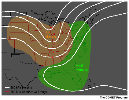
Southwest
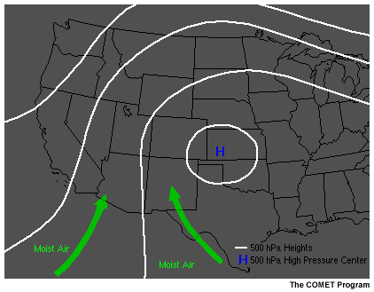
With the onset of the southwest monsoon, fire danger decreases in the Southwest, but regions near the northern and western edge of the monsoon moisture can experience increased fire danger. That's because the lower levels of the atmosphere remain dry while the mid-level moisture allows for the development of thunderstorms and the possibility of dry lightning. A breakdown or decrease in intensity of the ridge acts to enhance thunderstorm development.
Alaska
In Alaska, the breakdown of the ridge is usually quite rapid. Gusty winds associated with it can cause rapid spread of fires. In many cases, these effects are quickly mitigated by significant wetting rains, which rapidly decrease fire danger.
Foehn Wind
Recognizing Evolving Patterns
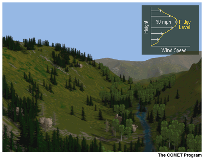
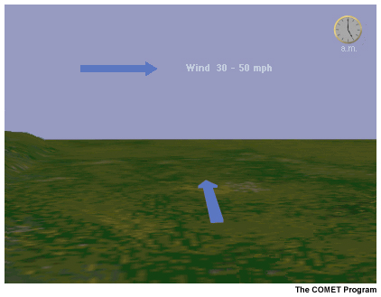
Santa Ana, Chinook, and East Winds are local names for foehn winds. These are strong downslope winds (30-50+ mph or 14-23+ m/s) that develop in the lee of major mountain ranges. They form when there are strong pressure gradients from one side of the mountain range to the other.
If sufficient moisture is available, strong winds above mountaintop level can often be detected visually by the presence of altocumulus standing lenticular (ACSL) clouds or smooth appearing cap clouds over the highest peaks. If these cloud types are present early in the day, be alert to the possibility of strong winds later in the day as the lower troposphere becomes more unstable and the low-level jet winds mix to the surface.
Associated Weather Conditions/Effects on Fuels and Fire Conditions
Foehn winds produce unseasonally warm and dry conditions. This is due to adiabatic compression of the air as it flows down the mountain range. The combination of warm, dry air and strong wind rapidly dries fuels and causes rapid fire spread if there are existing fires or if ignition occurs.
East Winds

East Winds affect the coastal areas of northern California, Oregon, and Washington. They are produced by a combination of moderate to strong subsidence and strong north to northeast winds aloft. The pattern is characterized by a strong, often positively-tilted ridge just offshore that begins to nose inland in northern British Columbia. The high pressure must be close enough to the coast to produce the subsidence effects in the mid-troposphere, resulting in clear skies.
East Winds often surface first at night and can persist for up to a week or more with varying strength. Typical speeds are 25-35 mph (11-16 m/s), but the rugged, dissected terrain can enhance speeds to more than 50 mph (23 m/s). Although fuels in these coastal areas are very heavy and usually moist, they respond rapidly to the strong drying effects of the downslope winds. Nearly all of the large fires in these areas have occurred under East Wind regimes.
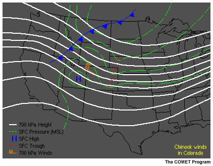
Chinook Winds
Chinook winds occur along the Front Range of the Rocky Mountains from Alberta southward to New Mexico. They also occur along the east slopes of the Cascade Range in Washington and Oregon and the Sierra Nevada Mountains in California and Nevada. They occur to a lesser degree along the east slopes of the Coastal Range in the northern Sacramento Valley of California, in the lee of the Appalachians, and along the north slope of the Alaska Range.
In the western U.S., chinook winds can be pre- or post-frontal and often occur from late August through November, although winter time occurrence is not uncommon in portions of Montana and Colorado. Keys to recognition include the formation of a leeside trough with high pressure building to the west, and low-level (just above mountaintop) jet formation with flow normal to the mountains and a stable layer above. Wind speeds of 40-60 mph (18-27 m/s) are common, and winds in excess of 100 mph (45 m/s) have been measured in Colorado. Fires during these wind episodes are usually human caused in lighter fuels (grass or grass--timber) and can have spectacularly rapid downwind growth.
In Alaska, strong, southerly winds over the Alaska Range and fronts passing to the northside accompany chinook events.
Santa Anas

Santa Anas are strong east to northeast winds that occur in southern California from the Tehachapi Mountains south to the Mexican border. They develop under relatively stable regimes with high pressure over Nevada and Utah and low pressure off the southern California coast. They can be as strong as 70-80 mph (30-35 m/s), but are more typically 30-50 mph (14-23 m/s). The strongest winds are channeled by terrain, blowing through mountain passes and canyons. Santa Anas can blow night and day for periods of 3 to 5 days. They often increase during the night and decrease or even lift above the marine boundary layer during the day to allow weak onshore flow near the coast.
Mid-Level Trigger
Recognizing Evolving Patterns
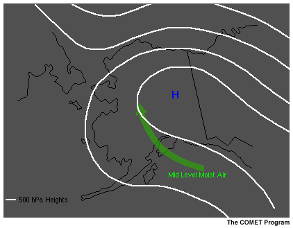
Mid-level triggers are of concern primarily during the summer fire season in the western U.S. They are characterized by a shortwave trough with some mid-level moisture. The moisture is often first apparent on water vapor satellite images. Early morning soundings with "inverted V" temperature-dewpoint profiles and moderate mid-level winds are another possible clue. The short wave is normally embedded in south-southwest to west-southwest flow regimes and may appear rather innocuous on upper-air height charts.
Associated Weather Conditions/Effects on Fuels and Fire Conditions
Short waves often trigger high-based thunderstorms that produce dry lightning and strong outflow winds. The lightning may start new fires and the strong winds can cause rapid fire spread.
Midwest and East
Typically, there is ample low-level moisture over the Midwest and East to produce wet thunderstorms in response to a mid-level trigger. However, it is always important to determine the moisture content of the atmosphere. If there is insufficient moisture for precipitation, dry thunderstorms may develop.
Rockies and Intermountain West
Shortwave troughs move over regions with very little low-level moisture, resulting in dry thunderstorms and lightning that may ignite fires. Outflow winds from the thunderstorms can rapidly spread new or existing fires. However, if sufficient low-level moisture is present, thunderstorms can be heavy precipitation producers. Thus, it is important to evaluate the moisture content of the atmosphere when these events are expected.
Large-Scale Subsidence
Recognizing Evolving Patterns

Subsidence occurs in areas of high pressure. It is important to fire weather because of adiabatic warming and drying in the subsiding air mass.
Associated Weather Conditions/Effects on Fuels and Fire Conditions
The effects of subsidence on the fire environment are quite dramatic when large areas of high pressure persist for long periods of time (10-20 days). The drying effects of the subsiding air mass can desiccate both live and dead fuels.
Regional Variations

In areas of mountainous terrain, subsidence inversions can lower to the level of higher ridges and peaks. This often occurs at night and can cause fires burning at higher elevations to suddenly "come to life." When the capping inversion descends below the level of the fire, convection is enhanced and fires may grow rapidly due to the lower dewpoints above the inversion. The most dramatic examples of the effects of subsidence are seen in the Intermountain West.
Dry Cold Front with String Winds
Recognizing Evolving Patterns
Dry cold fronts with gusty winds and little or no precipitation are most common in the western U.S. This pattern is often associated with the breakdown of the upper ridge.
Associated Weather Conditions/Effects on Fuels and Fire Conditions
Dry frontal systems are almost always accompanied by strong, gusty winds. Some dry fronts with weak upper-level support may be accompanied by little if any cloudiness. These systems are usually characterized by a rapid drop in the dewpoint and shifting, gusty winds. Active fires may spread more rapidly with the winds, and the direction of spread may change as the front passes.
Dry systems with moderate-to-strong upper-level support and some mid-level moisture may trigger high base thunderstorms that produce lightning but no rain. These systems have the potential to be very dangerous as lightning from the high/dry thunderstorms can start fires, and strong downburst winds quickly fan these fires into major conflagrations.
Eastern Half of the U.S.
In the eastern half of the country, dry fronts are possible during spring and fall. Many large fires occur during these times, especially under drought conditions. Extremely dry fuels in areas with deep duff (decaying material) or peat soils, such as in the north-central and southeastern states, moisten only with significant rain over long periods. Fires in these types of fuels can burn even under high humidities and often resurface weeks after the wet period that caused the fire to die down.
Western U.S.
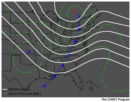
As frontal systems move onto the West Coast during the summer fire season, they encounter rugged mountain barriers that often stall the fronts and wring out most of their moisture. When a Pacific front pushes onshore, the thermal trough in the interior valleys of California and the Columbia Basin (central Washington and Oregon) is displaced into the Great Basin (Nevada, Utah, and western Idaho). This creates tremendous low-level instability, and strong pre-frontal south to southwest winds develop. Thunderstorms form as the residual moisture associated with the frontal boundary moves into hot, unstable interior areas. These storms are usually dry and often produce lightning which ignites fires. Strong post-frontal winds, which can spread fires rapidly, are usually short-lived.
In the fall and winter, the southern end of cold fronts may affect the southwestern U.S. These fronts may produce gusty shifting winds with few clouds and little, if any, precipitation.
Central Rocky Mountain Region
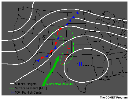
As fronts with limited moisture move into this region, they often stall for 1-3 days. Strong, warm, dry winds ahead of the fronts desiccate fuels. If the southerly flow over the area develops a subtropical connection, a dry lightning pattern may develop and ignite new fires.
Post-frontal winds are often persistent in the central Rocky Mountain region, enhanced by downslope effects in Colorado and northern New Mexico, and can cause rapid growth of lightning fires.
You should monitor water vapor images and determine the extent of the subtropical moisture, since significant moisture can result in heavy precipitation-producing thunderstorms that can mitigate fire activity.
Low-Level Jet
Recognizing Evolving Patterns
Low-level wind maxima, most often referred to as "low-level jets," can occur at any time of the year and in any area of the country. There are several types of low-level jets, including the well-documented nocturnal jet that occurs over the Great Plains during the convective season. Low-level jets are of primary concern to fire weather because they can cause rapid fire spread if they drop to the surface.
You should examine all soundings and low-level products to detect the presence or possible formation of low-level jets. They may be apparent on early morning soundings, characterized by light winds at the surface, with winds slowly increasing up to 2000-3000 feet AGL (600-900 m), and winds decreasing above the low-level jet. This sounding pattern has been referred to as a "reverse wind profile." Use caution when evaluating morning soundings because apparent low-level jet profiles may be induced by the formation of a surface-based inversion, and may totally mix out later in the day rather than dropping to the surface.
Low-level jets are associated with other weather phenomenon such as fronts, low- to mid-level short waves, and the breakdown of an upper ridge.
Associated Weather Conditions/Effects on Fuels and Fire Conditions
Fires can grow rapidly when a low-level jet surfaces. More importantly, the direction of the jet is often different from the surface winds, and a wind shift will occur when the jet surfaces. This can cause the direction of fire spread to change radically, putting firefighters in danger and affecting supression tactics and strategy.
Complex Mountain Terrain
When a low-level jet develops in complex terrain, higher topographic features may protrude into the layer of stronger winds. These stronger winds can produce rapid fire spread on upper slopes and ridges, even at night. With diurnal heating, these stronger winds can mix to lower elevations during the day.
Coastal Southeastern U.S.

The reverse wind profile is a very good predictor of gusty afternoon winds in some areas of the coastal southeastern U.S. The strong winds associated with the low-level jet can mix down to the surface as heating takes place. Fire weather districts in North and South Carolina have successfully used their knowledge of this process to forecast gusty afternoon winds.
Sea Breeze Front
Recognizing Evolving Patterns
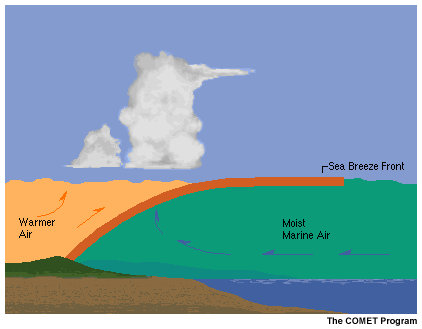
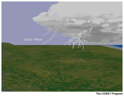
Sea breeze fronts develop when differential heating of the land and sea surfaces produces pressure gradients that force marine air inland. An area of low pressure develops over the heated land during the day and higher pressure remains over the water. The pressure difference results in the flow of air from the sea to the land. A sea breeze front develops along the leading edge of the marine air and thunderstorms often form along the boundary as it penetrates inland. The location and movement of convection associated with the sea breeze front are readily apparent on visible satellite imagery.
Land masses protruding from the main shoreline (such as the Florida peninsula) are often affected by converging sea breeze fronts.
Associated Weather Conditions/Effects on Fuels and Fire Conditions
The weather associated with sea breeze fronts and onshore flow varies greatly, depending on the temperature of the offshore water and the topography in the adjacent coastal areas. In areas where the water temperature is warm, moist and unstable air produces thundershowers along the sea breeze front. In areas where the water is cold, the air is cool, moist, and stable, resulting in fog and drizzle.
Sea breeze fronts are of concern to fire managers because they can produce strong, shifting winds prior to the increase in moisture. These winds can cause fires to rapidly intensify and change direction, which can cause safety problems for firefighters.
Coastal Southeastern U.S.
Sea breeze fronts are most common along the central and southern Atlantic coast, from Virginia south to Florida. They also occur along the coast of the Gulf of Mexico, from southern Florida north and west to eastern Texas.
The diurnal nature of the onshore flow allows a distinct boundary to establish and intensify as it migrates inland. Vertical motion along the boundary is enhanced by daytime heating. Thunderstorms may form along the boundary and although they are normally "wet," lightning and winds can cause fire problems, especially following periods of dry weather.
Further south in Florida, sea breeze fronts can occur from the Atlantic and the Gulf of Mexico simultaneously. The fronts converge in central Florida, triggering thunderstorms.
Western U.S. Coastal Areas
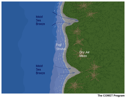
Gusty winds, which increase fire danger, often occur ahead of the marine layer intrusion. Higher humidities with the onshore flow quickly modify fine fuels, such as grasses, and decrease fire danger. The sea breeze can persist for hours before bringing higher humidities, fog, low clouds, and drizzle more than a few miles inland.
This regional variation is covered in more detail in the section on patterns that decrease fire danger.
Glossary
GlossaryContributors
Sponsors
National Weather Service (NWS)National Oceanic and Atmospheric Administration (NOAA)
Principal Science Advisors
Sharon Alden — NWSDave Goens — NWS
Paul Werth — NWS
Paul Gleason — U. S. Department of Agriculture (USDA), U. S. Forest
Service (USFS)/Arapaho and Roosevelt National Forests
Project Lead
Carl Whitehurst — UCAR/COMETInstructional Designer
Marianne Weingroff – UCAR/COMETProject Meteorologist
Elizabeth Mulvihill Page – NWSMultimedia Authoring/Additional
Instructional DesignEileen Kuo – UCAR/COMET
Carl Whitehurst — UCAR/COMET
Audio Editing/Production
Seth Lamos — UCAR/COMETComputer Graphics/Animation
Steve Deyo — UCAR/COMETHeidi Godsil — UCAR/COMET
Software Testing/Quality Assurance
Michael Smith — UCAR/COMETCopyright Administration
Lorrie Fyffe — UCAR/COMETSource Material Provided by
NOAA/NWSNational Interagency Fire Center (NIFC)
U.S. Forest Service
Voiceover Narration
Paul Gleason — USDA/FSTia Marlier — Garkie Communications, Inc.
COMET HTML Integration Team 2021
Tim Alberta — Project ManagerDolores Kiessling — Project Lead
Steve Deyo — Graphic Artist
Ariana Kiessling — Web Developer
Gary Pacheco — Lead Web Developer
David Russi — Translations
Tyler Winstead — Web Developer
COMET Staff
Director
Dr. Timothy SpanglerDeputy Director
Dr. Joe LamosMeteorologist Resources Group Head
Dr. Greg ByrdBusiness Manager/Supervisor of Administration
Elizabeth LessardAdministration
Penina FragerLorrie Fyffe
Bonnie Slagel
Graphics/Media Production
Steve Bollinger (Contract Employee)Steve Deyo
Heidi Godsil
Seth Lamos
Dan Riter (Contract Employee)
Hardware/Software Support and Programming
Steve Drake (Supervisor)Tim Alberta
David Ellis (Student)
James Hamm
Karl Hanzel
Ken Kim
Eileen Kuo (Student)
Max Parris (Student)
Carl Whitehurst
Instructional Design
Patrick Parrish (Supervisor)Dr. Alan Bol
Dr. Vickie Johnson
Bruce Muller
Dr. Sherwood Wang
Meteorologists
Dr. William BuaPatrick Dills
Kevin Fuell
Jonathan Heyl (Student)
Dr. Stephen Jascourt
Matthew Kelsch
Dolores Kiessling
Wendy Schreiber-Abshire
Dr. Doug Wesley
Software Testing/Quality Assurance
Michael Smith (Coordinator)National Weather Service COMET Branch
Anthony Mostek (National Satellite Training Coordinator)Brian Motta
Elizabeth Mulvihill Page
Dr. Robert Rozumalski (SOO Science and Training Resource Coordinator [SOO/STRC])