Stormwater
Weather and the Urban Watershed
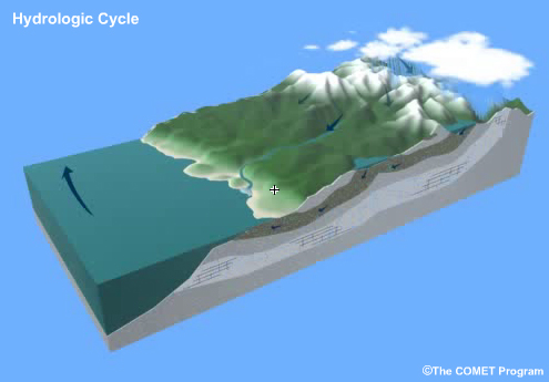
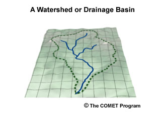
When the rain falls and the snow melts, all of the resulting runoff moves through the local watershed, our environmental home. What happens to that water as it makes its way to our rivers and streams? That all depends on the characteristics of the local watershed.
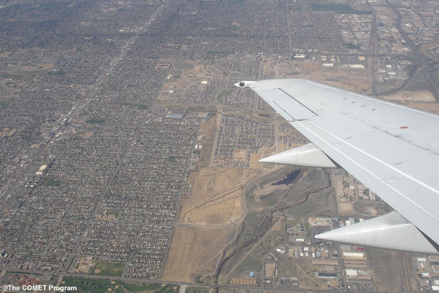
In an urban setting, the watershed has most likely seen considerable changes from its natural state. The flow of water in an urban drainage is very different from a less developed one. Major rivers or streams may be confined to narrow, straight banks. Smaller creeks and streams might be diverted into concrete-lined ditches or culverts. Wetlands might be drained and replaced with parking lots, buildings, or roads and highways. Woodlands and fields are few and far between, mostly paved over as well.
All of these changes to the environment play a major role in how water moves through the urban watershed and on its quality as it moves into the rivers, lakes, wetlands and coastal areas downstream.
Stormwater: Infiltration and Impervious Surfaces
Question
If you took all the built-up surface areas of the lower 48 United States and created one big continuous urban area, how much land surface would you need to pave over?
An area the size of:
The correct answer is c.
Please watch the video below.
A NOAA study in two thousand and four reveals that all of the built-up areas of the lower forty eight states combined covers an area close to the size of Ohio: somewhere around forty four thousand square miles.
Considered on that scale, you can imagine the impacts that such enormous changes would have on the natural drainage system. What would happen in this super-sized city after a warm sunny day following a blizzard that leaves a foot of snow? Where would all that water go?
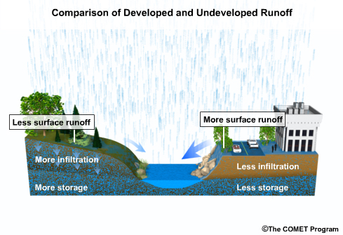
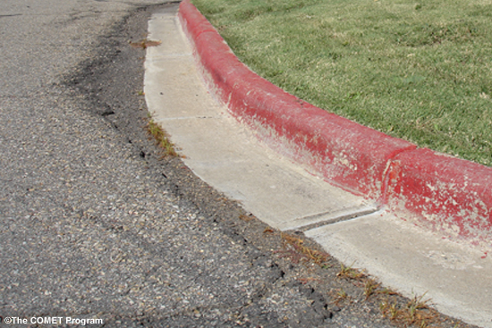
Rain that falls on impervious – that is, impenetrable – surfaces, such as roofs, parking lots and streets, cannot infiltrate, or sink into, the soil and drain slowly into local waterways. Instead, it flows relatively quickly over the ground until it reaches a channel. The larger the area of an impervious surface, the more water collects in gutters, sidewalks, streets, and storm drains. This urban run-off is known as stormwater.
Impervious surfaces aren't just concrete and asphalt streets and parking lots, but also buildings, sidewalks, and even lawns. Compacted soil, such as that found under many lawns built on top of construction debris, only allows for limited infiltration.
With paved areas producing five to sixteen times as much runoff than an undeveloped meadow or woodland, water that would otherwise seep into the ground and help recharge the water table below, is instead piped downstream. The net effect of this lost water is not the same in all settings and its impact is only partly understood.
One study conducted by American Rivers, the National Resource Defense Council, and
SmartGrowth America, looked at metropolitan areas that experienced the most development in
the past twenty years. They used various data sources to estimate the amount of water lost
to runoff each year due to impervious surfaces. Though their figures are only estimates,
they do provide a picture of how the built environment impacts water infiltration. Between
nineteen eighty two and nineteen ninety seven, Atlanta's impervious surfaces annually
flushed somewhere between fifty eight to one hundred thirty three billion gallons of water
downstream rather than allowing it to infiltrate the local water table.
That's enough
water to supply as many as three point six million people.
Of course a super-city the size of Ohio doesn't exist. But even broken up, all the paved and built-over areas that make up our local cities and towns create stormwater which has an impact on the local watershed. The impact on the water quality of the surface water and the local aquifer varies depending on the percentage of land coverage made up of impervious surfaces in a watershed. Research indicates that ten percent impervious coverage can have a significant impact on most watersheds. More sensitive semi-arid sub-basins, such as Phoenix, will show irreversible impacts at three to five percent coverage.
Stormwater and Pollution
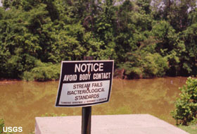
On of the major issues municipalities need to deal with when it comes to stormwater is pollution. Stormwater picks up pollutants on the ground along its path. This polluted run off can have devastating impacts on downstream rivers, lakes, wetlands and coastal waters.
The Clean Water Act of nineteen seventy two set the stage for the EPA to regulate sources of pollution discharged into our waterways. In its early days, the Clean Water Act was very focused on "point sources" of pollution, such as industrial plants and sewage treatment facilities. And it has been very effective in cleaning up those sources of water-born pollutants. Since the nineteen eighties, the Act has been amended to also address pollution that isn't easy to pin point to a single source. This type of polluted run off is often referred to as non-point source pollution.
Polluted run off comes from diffuse sources such as pesticide and fertilizer from lawns and gardens; oil, coolants, rubber and brake pad dust from cars; and salt and magnesium chloride from snow removal.
Not all polluted run off is necessarily considered man-made. The accumulation of tree pollen, leaves, lawn clippings; bacteria from pet waste in parks; sediment from construction sites; and other natural organic matter can also have a negative impact on downstream waterways by increasing nitrogen, phosphorous, bacteria and turbidity levels.
Nitrogen and phosphorous are chemical nutrients, the primary ingredients of fertilizer. When their levels increase—a process called eutrophication—it usually leads to increased plant, algae and bacteria growth which in turns leads to a decrease in available oxygen for native plant and animal species. In extreme cases, this process can throw an ecosystem like an estuary out of balance. Polluted runoff and eutrophication in this sensitive ecosystem can close beaches and harm or kill fish and shellfish.
An additional impact from stormwater in some parts of the country is its temperature. As rain falls on hot, impervious surfaces, the runoff can become much warmer than the runoff on a comparable natural surface. Though water temperature isn't really considered "pollution", it can have similar impact on the biology of the watershed. Warm stormwater can induce growth of unwanted warm-water plant and animal species and lead to excess bacterial growth. It's a major issue in the Pacific Northwest and other areas with valuable cold water fisheries.
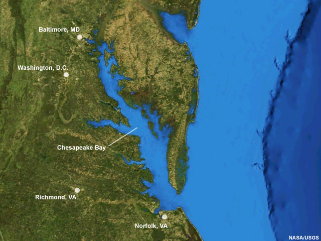
Every summer the Chesapeake Bay, the largest estuary in the United States, shows the impacts of warm, nutrient-rich run off. It's the cause of large dead zones, areas of low levels of dissolved oxygen, with negative impacts on the valuable commercial and recreational fisheries. Similar events happen annually in other coastal estuaries, such as the Gulf of Mexico off of the Mississippi delta.
Stormwater and Flooding
Another major concern with stormwater is the increase in volume and speed as it collects in the myriad storm drains and gutters heading downstream. The sudden increase in run-off can lead to urban flooding and, once the stormwater reaches creeks and rivers, to streambed erosion.
Question
Hydrographs show the volume of run off at a given point in a stream over time. Characteristics of the stream upstream of the point, such as its surface roughness, amount of meandering, number of feeder channels (known as stream density), and imperviousness, all impact this measurement. Take a look at these three simplified hydrographs and see if you can match them to their watershed type.
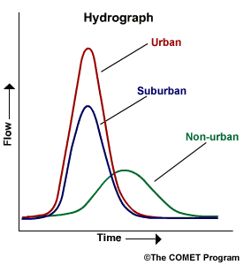
As the watershed becomes more developed, there will be a quicker peak to the volume of water during a precipitation event due to the reduction in amount of rough surface for water to flow over (this speeds the movement of water), a decrease in meandering (as streambeds are straightened and redirected into manmade channels), an increase in stream density (every road acts as another stream channel and thus increases volume of water flowing downstream), and the amount of impervious surfaces increase (increasing volume of run off).
Please continue watching the video above.
Comparing a hydrograph (a graph of runoff volume vs. time) in an urban watershed versus a watershed in its natural state, you can see that the potential for flooding is higher in an urban setting. The lack of infiltration due to impervious surfaces causes the stormwater to rapidly build in volume to a peak flow and then rapidly diminish. In areas with infiltration and more natural stream channels, the peak is less and it's spread out over time.
The stormwater system in an urban area may be designed to handle the rapid build up of water volume during a heavy precipitation event, but that water is all heading downstream. And the natural streambed below will be affected by the increased volume and rate of the stormwater.
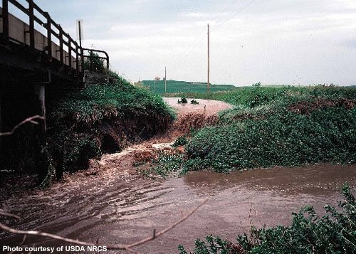
Erosion and alterations to the stream banks and streambeds can lead to flooding and damage to nearby properties, while an increase in turbidity – or cloudiness -- and sedimentation can harm aquatic life.
If a municipality's storm drain system is connected to a sewage treatment plant, as it is in many older cities, a major precipitation event can quickly lead to stormwater loads that will overburden the system and cause sewer overflows. Such events can lead to sewer backups, known as "combined sewer overflows" in homes and in waterways within the urban area but also have impact downstream by contaminating fisheries and closing downstream beaches.
Culprits in the Urban Landscape
Let's take a closer look at some of the features of the urban landscape with the greatest impacts on stormwater flow.
Rain that falls on city rooftops usually flows through gutters and downspouts to driveways and storm drains. For many homeowners, directing downspouts to a driveway lowers the risk of foundation or basement flooding.
Question
How much water can be collected off of a roof measuring 2000 square feet, a typically sized roof for a house, during a one-inch rainfall event?
The correct answer is d. That's a lot of water.
Please continue watching the video above.
A house with a typical rooftop area of two thousand square feet will produce around one thousand gallons of water from a one-inch rainstorm. A whole city of such houses produces rivers of water that can swamp stormwater systems.
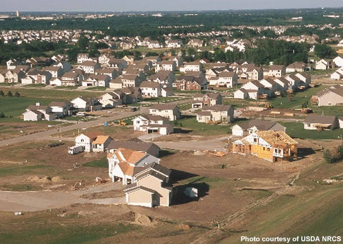
How homes are placed on lots also affects runoff. Many zoning codes require "setbacks," or minimum distances from the street or sidewalk to a house. Setbacks expand the amount of land needed to place development, increasing paved area and impervious surfaces. A Massachusetts Institute of Technology researcher found that 50 percent of the land is paved in typical residential subdivisions with 20-foot driveway setbacks.
Though lawns are typically but incorrectly viewed as permeable landscapes, they are not. Scientists have found construction work frequently compacts the soil and limits its absorptive power. According to the Center for Watershed Protection, the bulk density of some lawns is similar to concrete.
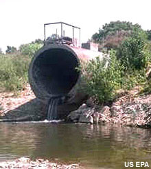
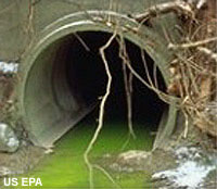
Roads and parking lots, on the other hand, are a well-known source of runoff. Street gutters quickly fill with water during storms and usually direct it into storm drains. From there, the water is directed into a local creek, a sewage treatment plant, or a retention pond. With the exception of retention ponds, very little of that water is retained for local infiltration. Instead, it heads downstream.
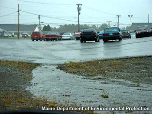
Parking lots handle water like roads, and in addition, are often bigger than they need to be. Cities may have formulas that calculate the required number of spots, and they may greatly overestimate what is needed. Olympia, Washington, conducted a survey of parking space occupancy rates and found that over one-third of the spaces were not used; during times of peak parking demand, occupancy rates were less than 75%.
A similar 2007 study by Purdue University of Tippecanoe County, Pennsylvania, found three public parking spots for each county resident. By their calculations, the parking lots generated a twenty-five-fold increase in storm water runoff and over one thousand pounds of heavy metal runoff from parked cars.
Parking lot landscaping can also compound the problem. City code often requires that landscaping be elevated at a minimum of 6 inches above the parking lot grade to provide a curbed tire stop. But such curbs prevent runoff from accessing and infiltrating the permeable grass and mulch in the landscaped parts of lots.
Reducing the Impact
Continued growth and development of our urban environment is inevitable. But there are ways to mitigate the impact of wet weather events on urban runoff, both in terms of reducing the amount of runoff and in lowering pollution levels. Mitigation efforts need to take place at the municipal level as well as in everyone's backyard.
Many cities are adopting low impact designs for municipal projects, amending zoning laws and ordinances, and putting educational efforts in place to raise awareness. Cities with combined sewer systems (stormwater and sewage), such as Chicago, Milwaukee, Pittsburgh and Portland, have built or are building large retention systems to hold excess run-off during large precipitation events for later treatment.
And in Chicago, a massive long-term project is underway to replace the nearly 2000 miles of
impermeable back alley pavement with porous concrete. This effort will reduce runoff and
relieve the load on the city's strained sewer system.

Mitigation can start at a large or a small scale. Every drop adds up.
Take Aways and References
Story Ideas
The following are suggestions to develop viewer segments related to this unit's content.
Runoff-related environmental and water quality issues
“Mommy, why can’t I go swimming?” A kid’s eye view of what it’s like to be forbidden from swimming or fishing in certain streams because of urban runoff. Increasingly, kids don’t have access to this simple form of urban recreation.
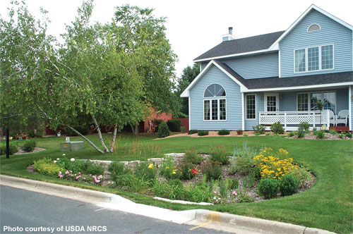
Rain Gardens
One of the most approachable low impact development techniques is rain gardens. These gardens take advantage of depressions of low spots in yards. These low spots help infiltrate stormwater, filter water and trap soil particles that otherwise would enter the public conveyance system.
A public interest story centered on rain gardens can include:
- A guest appearance by a local Extension Agent or Landscape architect with preferred plants.
- Check to see if your city or town has a program that encourages rain gardens. Kansas City, Missouri has adopted the goal of 10,000 rain gardens. The programs aims to improve water quality, reduce flooding, and reduce storm sewer overflows. See https://rainkc.com/ for details.
Weather-related home improvements
Home improvement shows have been tremendously popular in recent years. Consider incorporating some of these home-improvement ideas into a segment on weather-related home improvement. You can include:
- permeable paver driveways
- rooftop gardens
- maintaining natural buffer zones
- landscaping with low-maintenance, drought-tolerant native plants
- planting trees or rain gardens
- down spout rerouting to rain gardens.
You could discuss how these methods help homeowners on a daily basis while helping the community on an ongoing basis and during rare times of disaster. Emphasize the benefits to viewers first -- these home-improvement ideas can help keep viewers’ lawns and trees greener and lower summer energy and water bills – and then the benefits to the community – they help prevent dangerous flash flooding, reduce stream pollution in streams neighborhood kids play in, and promote a healthier water table.
You could also interview some local homeowners who’ve implemented these techniques to show what they look like, how a real person did it, and what they think of the results. You may be able to find people to interview by calling a local garden club, garden center, or home-improvement store. You may try contacting a locally-owned gardening or home-improvement center see if you can show some examples of materials or plants on-air. Local businesses are usually eager for the free advertising, while you may have to go through corporate channels for larger chain stores.
Stormwater Ponds
Stormwater ponds have been, and will continue to be, a prominent feature of the built environment. Homeowner attitudes on ponds vary, from development amenity to nuisance. However, homeowners need to be aware of the environmental role they play since ponds can fail when they fill with sediment from runoff. Failed ponds aren’t just an environmental problem. They can also cause property damage, endanger public safety, and require expensive repairs – bills that taxpayers will foot.
Stories centered on stormwater ponds can include:
- The environmental and flood prevention role of ponds, especially if a rainy season is approaching.
- Individual homeowners’ roles in maintaining the neighborhood pond. Viewers may not be aware that as ponds fill with sediment, they lose storage, which raises the potential for overflow and flooding. Individual homeowners should be aware that mud flowing from construction sites or disturbed soils is a main culprit. The segment could show what a properly installed silt fence looks like, and tips on working with contractors to correct any problems.
"Do Not Feed" programs
Geese and bird droppings are a large water quality problem in many parts of the country. One segment could focus on simple actions homeowners can take to avoid attracting large numbers of bird to nearby ponds. You might also interview a local veterinarian who could explain why feeding waterfowl is bad for birds’ health, and a local water quality or public health expert to explain why large waterfowl populations (and their droppings) are dangerous for water quality and public health.
Storm Grates
Viewers might be familiar with "Do Not Dump" signs posted on stormwater inlets. These signs are intended to warn citizens against dumping oil or other pollutants into the storm system. However, leaves and trash can also pose big problems by clogging the inlets. This can cause localized flooding during storms by preventing water from entering the conveyance system.
Stories centered on storm grates can include:
- A "guest feature" with the storm inlet as your guest. Many viewers are not aware that water entering the storm drain is deposited – untreated – into local waterways. In some older cities, stormwater is diverted to a treatment plant, but for most cities, the pipes flow directly to receiving waterways. The "Think Blue" campaign in San Diego features a rubber duck and its journey to the ocean through underground pipes. The radio and print spots are intended to educate the audience on keeping trash out of storm grates. The "Think Blue" outreach resource page is www.sandiego.gov/thinkblue/outreach/index.shtml.
- At the onset of fall, your station could run a segment on leaves and leaf collection. As noted above, leaves can clog storm drains; a leaf-clogged drain has been implicated in fatal flooding that occurred in Seattle, Washington in 2006.
- Decaying leaves, many of which are sent into waterways from storm sewers, can pose environmental problems. As leaves decay, they release nutrients. These nutrients may then be available for nuisance species, such as algae. If your community sponsors curbside leaf vacuuming, you may want to ask viewers to rake leaves to the curb as close as possible to the leaf collection date. Likewise, ask viewers to report leaf-clogged inlets to the Public Works department, especially if heavy rains will coincide with peak leaf drop.
Viewer Tips
Earth Gauge™ Tips
http://www.earthgauge.net
Ten Ways to Protect Water Quality
- Just one tree can reduce rainwater runoff by 4000 gallons each year! Add trees to your property to absorb and filter rainwater, reduce flooding and erosion, and protect water quality
- Instead of hosing off your sidewalks and driveway, which can carry oil, antifreeze, and other pollutants into the storm drain, use a broom and dust pan to clean up. Not only will you help prevent water pollution, but you’ll also save water.
- If you live near a river, stream, or lake, protect water quality by letting part of your landscape “go wild.” Leaving a buffer of naturally-growing shrubs and grasses at the edge of your property will help to absorb and filter rainwater before it reaches the water; it will also help prevent soil erosion on your property.
- If you remove snow from your driveway or sidewalks, try to shovel it onto your lawn or another grassy area, instead of pushing it into the street. This will allow snowmelt to soak into the ground, where it can be filtered by the soil, rather than running off into the storm drain.
- Thinking about adding or replacing a walkway at your home? Consider using materials that are less likely to absorb heat, such as gravel, grass, or mulch. Not only will these materials stay cool, but they’ll also allow rain water to soak into the ground instead of running off into the street.
- Instead of letting rainwater run into the storm drain, capture it by making use of your landscape. If you have a sloped surface, grow water-absorbent plants at the bottom of the slope, or build a rain garden to catch the water so that it can recharge the water table.
- Never dump oil, antifreeze, paint, yard waste, or other materials in or near a storm drain where they can be carried directly to streams, rivers, and lakes untreated. Instead, take your household hazardous wastes to a local collection facility. Call 1-800-CLEANUP or visit www.cleanup.org to find a collection site near you.
- Lower the load on combined sewer systems during heavy rains by conserving water at home. Wait until after the storm for household activities that use large amounts of water, such as running the dishwasher or the washing machine.
- Hold your ground - reseed bare spots in your lawn, and add mulch around plant beds and other bare areas to prevent soil loss. If you’re planning a construction project, be sure to cover any dirt piles or bare areas with a tarp to keep materials in place.
- About five percent of Americans who change their own oil do not dispose of it properly. Collect used motor oil in a clean container with a lid (such as a tin can) and take it to your local service station or household hazardous waste collection facility for proper disposal.