KEY FEATURES OF THE WEST AFRICAN MONSOON
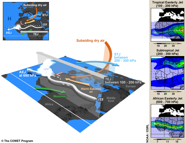
- Monsoon:
-
The cool and humid southeast wind flow (green arrow) from the St Helena anticyclone veers southwest after crossing the equator. The monsoon flow is the main source of moisture for the development of convection over West and part of Central Africa during the rainy season. Note that a monsoon depth of 1000 to 2000m is required for the initiation of deep convection. The monsoon converges with the Saharan dry air around the intertropical front.
- Warm Saharan Air:
-
This is the dry, hot wind (the yellow arrow) from the north that crosses the Sahara and converges with the monsoon over West and part of Central Africa. The dry air forms a dome 4 to 5 km high over the Sahara desert, creating the Saharan heat low. The intensity and location of the heat low affects water vapor transport and convection in West Africa. For example, as the low becomes more intense, the pressure gradient increases between the heat low and the cool Atlantic. This leads to enhanced moisture convergence inland (northward) and more favorable conditions for moist convection.
- Intertropical Front (ITF):
-
The ITF, also known as the Intertropical Discontinuity, is the separation zone between the dry Saharan air and the monsoon flow over West Africa. It is generally associated with Saharan heat lows. Convective systems do not develop along the convergence line due to the weak thickness of the monsoon layer in the zone and subsidence in the mid-troposphere. Deep convection is found 3 to 5 degrees south of the ITF
- Heat Low:
-
A heat low is an area of high surface temperatures and low surface pressures. (Note that the threshold for pressure values varies throughout the day due to the intense diurnal heat cycle.) Heat lows exist throughout the year and occur where insolation is high and evaporation is low. During the summer, the West African heat low is generally positioned over the Sahara and is often referred to as the Saharan heat low. During this period, the heat low is one of the major dynamic elements of the West African monsoon system.
- African Easterly Jet (AEJ):
-
The AEJ is a mid-tropospheric easterly wind maximum located between 700 and 600 hPa over Sahelian Africa during the northern hemispheric summer. The AEJ has mean maximum speeds of 10-13 m/s. The jet is the easterly geostrophic flow response to the strong temperature gradient between warm Saharan air layer and cool monsoon air to the south. African easterly waves, which produce severe thunderstorms, have their maximum amplitude close to the level of the AEJ but south of the AEJ.
- African Easterly Waves (AEWs):
-
These are the dominant synoptic weather systems of the summertime West African Monsoon. AEWs are associated with convective heating in the Intertropical Convergence Zone (ITCZ) and instabilities in the AEJ. Africa easterly waves commonly have two vorticity maxima, one at the low-levels in the vicinity of the ITF and one at the AEJ level in the rainy zone south of the jet. Easterly waves are often identified by meridional oscillations in the AEJ.
- Subtropical Jet (STJ):
-
This jet, sometimes called the subtropical westerly jet, is a strong westerly wind over the Sahara desert between 200 and 300 hPa. When the STJ is strong, it helps reinforce deep convection in the northern branch of the diverging anticyclonic flow at the top of MCSs over West and part of Central Africa during the rainy season. On the equatorial side of the jet, there’s an area of dry stratospheric subsiding air, which maintains strong stability over the Sahara desert in the mid-troposphere.
- Subsidence or Dry Air Intrusion
-
This is a dry, cold air mass, known as a dry air intrusion in West Africa, which originates from the polar jet. It is transported eastward up to around 0 degrees longitude where it starts to subside and feed into the mid-troposphere over West Africa. A dry air intrusion is identified as a cold air trough that sometimes forms over the northern part of the continent and the Sahara desert. The dry, cold air flow accelerates monsoon inflow into West Africa and plays a key role in the development of strong convective systems in the region.
- Tropical Easterly Jet (TEJ):
-
The TEJ is a strong easterly wind flow between 200 and 100 hPa that extends from the Tibetan mountains to Africa and generally exits over the Gulf of Guinea. During the rainy season, it helps reinforce deep convection in the southern branch of the diverging anticyclonic flow on top of MCSs over West and part of Central Africa. When the jet is weak, it can inhibit deep convection.